


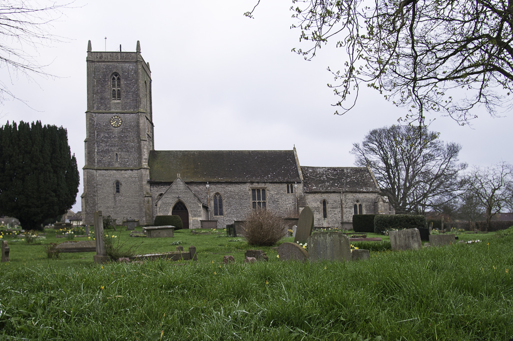

Pucklechurch, United Kingdom
Pucklechurch is a town of 2,364 people in England, United Kingdom.
Why visit Pucklechurch
Townapedia lists 3 museums and landmarks, 7 parks and trails, 14 places to eat, 1 place to stay and 1 attraction in and around town.
Highlights include Engine House, Dyrham Park and Page Park.
Weather in Pucklechurch
Forecast from MET Norway (CC BY 4.0). Full forecast
About Pucklechurch
Pucklechurch is a village and civil parish in the South Gloucestershire district of Gloucestershire England. The parish also incorporates the hamlet of Shortwood to the west of Pucklechurch village, and Parkfield to the north-west, with a total population of 3,209 at the 2021 census data. The village dates back over a thousand years and was once the site of a royal hunting lodge, as it adjoined a large forest.
From the Wikipedia article Pucklechurch (this version), under CC BY-SA 4.0.
Things to do1

Museums and landmarks3


Parks, trails and playgrounds7

Dyrham Park
Park · 2.7 mi
Park in Gloucestershire, England, United Kingdom

Page Park
Park · 2.8 mi
Park in Staple Hill, South Gloucestershire, United Kingdom



Restaurants and cafes14
Costa
Cafe · Coffee Shop · 1.8 mi
Emerson Way, Bristol
Mo-Fr 07:00-19:00; Sa,Su 08:00-17:00

The Bridge Inn
Bar and pub · 1.6 mi
Bridge Road, Bristol
Mo-Sa 11:00-23:00; Su 12:00-10:30

2 more on the map.
History
The parish has archaeological and historic assets including a Bronze Age barrow cemetery on Shortwood Hill and the remains of a World War II barrage balloon depot. The earliest human activity in this area dates to the prehistoric period and archaeological evidence suggests it was inhabited during Roman times. It was of national importance in the Anglo-Saxon world, being situated on the edge of the Kingswood Forest. By the mid 900s it was a substantial Saxon settlement and royal administrative centre with a minster church.
The Anglo-Saxon Chronicle states that King Edmund I was murdered at Pucklechurch, in 946: "A.D. 946. This year King Edmund died, on St. Augustine's mass day. That was widely known, how he ended his days: that Leof or Liofa stabbed him at Pucklechurch."
The name of the settlement comes from the Saxon which means 'Pucela's church'.
An area listed behind the Star Inn is thought to be the site of the king's lodge or palace, but as yet no archaeological evidence has been uncovered that supports this assertion. In 950 King Eadred gave land (at Pucelancyrcan) to the Abbey of Glastonbury.
The Domesday Book of 1086 records this land as belonging to St Mary's church, which was in Glastonbury Abbey's grounds. It notes:
Read more of the history
[The church of] St Mary of Glastonbury holds Pucklechurch. There are twenty hides. In demesne are six ploughs and twenty three villans and eight bordars with eighteen ploughs. There are ten slaves and six men render 100 ingots of iron less ten and in Gloucester one burgess pays 5d and two coliberts pay 34d and there are 3 Frenchmen and two mills rendering 100d. There are sixty acres (24 ha) of meadow and woodland half a league long and a half broad. It was worth £20, now £30 [to its overlord per year].
The manor of Pucklechurch was held by the Bishop of Bath and Wells from 1275, who received it from Glastonbury Abbey, as a document in the Calendar of Bishops of Bath and Wells, dated April 1275 records:
Accord between Robert Bishop of Bath and Wells and John Abbot of Glastonbury, namely that whereas Robert late Abbot of Glastonbury and the convent quitclaimed to Walter late Bishop of Bath & Wells the manor and advowson [right to appoint the priest] of Pokeleschyrch [sic] ...
The church of St Thomas a Becket largely dates to the 1200s and 1300s from the time when it was under the Bishop's patronage. Its listing emphasises how visible the original stonework fabric is and says "it is substantially a medieval building"; its Victorian amendments were "carried out by R. C. Carpenter, and later by J. D. Sedding ... of good quality, reflecting the involvement of these experienced ecclesiastical architects". Of particular note there are the remains of two effigial monuments in the lady chapel that date to the 1370s and attributed to William de Cheltenham (d. between 1371 and 1374) and his wife Eleanor.
To save his see from the administrative burden of collecting all the rents within the manor, the bishop farmed the manor to Sir Gilbert Denys (d. 1422), who already held the nearby manor of Siston. This gave Denys the right to keep all the rents he could collect in exchange for an annual one-off payment of £40. Payments made by Denys are recorded in the communar's accounts of the See of Bath and Wells.
It appears that Denys held the manor until his death in 1422, although records are not available to confirm this. At the dissolution of the monasteries the manor was granted to William Herbert, 1st Earl of Pembroke from whom it was acquired by Sir Maurice Denys (d. 1561), treasurer of Calais and builder of Siston Court. From him the manor passed to his cousin Hugh Denys, and a cadet (younger) branch of the Denys family became lords of the manor of Pucklechurch until the death of William Dennis in 1701, last of the male line. The Heralds' Visitation of Gloucestershire in 1623 records John Denys (d. 1559) as "of Pucklechurch", High Sheriff of Gloucestershire in 1551. He was the youngest son of Sir Walter Denys (d. 1505) of Alveston, buried in Olveston Church, and the youngest brother of Sir William Denys (d. 1535) of the adjacent manor of Dyrham. In St Thomas a Becket Church is a memorial to Henry Dennis (d. 1638), Squire of Pucklechurch, son of John Dennys, fisherman and poet who wrote the earliest English poetical treatise on fishing, "The Secrets of Angling", published in 1613.
Coal has been extracted from the area since at least early medieval times.
Bristol Archives holds documents detailing the leases and sale of the coal mining rights by Mary and Elizabeth Dennis, the co-heiresses of William Dennis (d. 1701). A deed dated 2 February 1719 reads:
Articles of Agreement – 1) Mary Dennis of Westminster, Middx. singlewoman 2) John Whitewood of Mangotsfield, Glos., coalminer and Daniell Alsopp of Pucklechurch, Glos. yeo. – granting licence to dig for coals upon farm in or near Shortwood in Pucklechurch rented from her by Daniell Alsopp and to carry away and sell the same. Term 120 years. Whitewood and Alsopp to pay her 3s. for every 20s. worth of coal. Covenants re.making good of damage, appointment of clerk to keep accounts, etc.In 1851 Handel Cossham established the Kingswood Coal Company, which included a mine in Pucklechurch. By 1900, the Bristol coalfields were producing nearly 500,000 tonnes. Parkfield Colliery operated in Pucklechurch from 1851 to 1936. Brandy Bottom Colliery, part of Parkfield Colliery is a scheduled monument that contains the remains of a complete 19th century steam powered colliery.
Shortwood Brick and Tile Company began producing bricks in the late 1800s and closed in 1969, having been acquired by the Cattybrook Brick Company in 1903. It made use of the good quality red clay found above the coal seams. This clay was fired to make millions of bricks for local buildings – at peak production, the works produced more than half a million bricks per week.
From the History section of Pucklechurch on Wikipedia, under CC BY-SA 4.0.
More about Pucklechurch
Geography
Pucklechurch village is situated on a prominent landscape ridge that sits above Bristol and below the backdrop of the Cotswold escarpment. It is located 7.4 miles (11.9 km) east-northeast of Bristol city centre and 8.9 miles (14.3 km) northwest of the city of Bath. The parish as a whole sits within the Pucklechurch Ridge and Boyd Valley landscape character assessment area, as defined by South Gloucestershire Council. Settled areas sit within a diverse undulating rural landscape of mainly mixed farmland. A major defining influence to the north of the parish is the M4 motorway.
From the Wikipedia article Pucklechurch, under CC BY-SA 4.0.
Notable people from Pucklechurch
- Walter Wigmorefootballer (1873-1931)
Born in Pucklechurch, according to Wikidata (CC0). Each name links to its Wikipedia article.
Where to stay1
Churches and places of worship10
Shopping5
Schools, colleges and libraries5
Healthcare1
Map of Pucklechurch
47 places. The map loads OpenStreetMap tiles when you open it.
Getting there and nearby towns
Bristol Airport (BRS) is the nearest airport with scheduled flights listed in OpenStreetMap, 14 miles away.
- Mangotsfield 3 mi west, about 5 min by car
- Warmley 3 mi southwest, about 4 min by car
- Kingswood 4 mi southwest, about 6 min by car
- Yate 4 mi north, about 6 min by car
- Stoke Gifford 5 mi northwest, about 8 min by car
- Marshfield 5 mi east, about 8 min by car
- Keynsham 6 mi southwest, about 9 min by car
- Bristol 7 mi west, about 12 min by car
- Bath 8 mi south, about 13 min by car
- Almondsbury 8 mi northwest, about 12 min by car
Drive times are estimates from straight-line distance, not routes.
Towns near Pucklechurch


Keep exploring
Local news
Headlines from INDB.
Reviews, tips and questions
Loading what members have shared...
Sources and licences
- GeoNames (CC BY 4.0): population, coordinates, regions and time zone
- Mapillary (see each image): photos
- OpenStreetMap contributors (ODbL 1.0): places, airports, map data
- Wikidata (CC0 1.0): elevation, founding date, time zone, website, landmarks and historic places
- Wikimedia Commons (see each image): photos
- Wikipedia (CC BY-SA 4.0): overview and history text
Photo credits
- Dyrham Park lower park, Rwendland, CC BY-SA 3.0
- Dyrham Park, house and church, from lawn, Rwendland, CC BY-SA 3.0
- Kingswoodchurch, Rod Ward, Public domain
- Original Whitfield Tabernacle (Derelict) 1741. - panoramio, Bob&Anne Powell, CC BY-SA 3.0
- ChurchatPucklechurch, http://www.wyrdlight.com Author: Antony McCallum, CC BY-SA 3.0
- SistonChurch, Lobsterthermidor at en.wikipedia, CC0
- Church Farm Colliery, Former Pumping Engine House. - panoramio, Bob&Anne Powell, CC BY-SA 3.0
- Clock Tower, Page Park. - panoramio, Robert Powell, CC BY-SA 3.0
- Street-level photo, southglos, CC BY-SA 4.0
- Street-level photo, milliams, CC BY-SA 4.0
- Street-level photo, southglos, CC BY-SA 4.0
- Street-level photo, southglos, CC BY-SA 4.0
- Street-level photo, southglos, CC BY-SA 4.0
- Street-level photo, southglos, CC BY-SA 4.0
- Street-level photo, southglos, CC BY-SA 4.0
- Street-level photo, southglos, CC BY-SA 4.0
- Street-level photo, southglos, CC BY-SA 4.0
- Street-level photo, southglos, CC BY-SA 4.0
- Street-level photo, southglos, CC BY-SA 4.0
- Street-level photo, swinetown, CC BY-SA 4.0
- Street-level photo, southglos, CC BY-SA 4.0
- Street-level photo, swinetown, CC BY-SA 4.0
Page built November 10, 2026. Spotted a mistake? Tell us or suggest a place.