

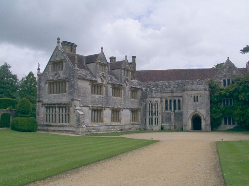


Puddletown, United Kingdom
Puddletown is a town of 1,158 people in England, United Kingdom.
Why visit Puddletown
Townapedia lists 3 museums and landmarks, 1 place to eat and 4 attractions in and around town.
Highlights include Athelhampton House and Thomas Hardy's Cottage.
Weather in Puddletown
Forecast from MET Norway (CC BY 4.0). Full forecast
About Puddletown
Puddletown is a village in the civil parish of Athelhampton and Puddletown, in Dorset, England. It is situated by the River Piddle, from which it derives its name, about 4.5 miles (7 km) northeast of the county town Dorchester. Its earlier name Piddletown fell out of favour, probably because of connotations of the word "piddle". The name Puddletown was officially sanctioned in the late 1950s.
From the Wikipedia article Puddletown (this version), under CC BY-SA 4.0.
Things to do4

Museums and landmarks3


Thomas Hardy's Cottage
Museum · 2.0 mi
Cob and thatch building in Stinsford, Dorset, England, UK

Restaurants and cafes1
Churches and places of worship4
Church of Saint John the Evangelist
Church · 2.2 mi
Church building in Tincleton, West Dorset, England, UK

Church of Saint John, Tolpuddle
Church · 2.3 mi
Grade I listed building in Tolpuddle, Dorset, England, UK
History
Evidence of prehistoric human occupation in the parish exists in the form of 30 round barrows, about half of which are sited over chalk and half over Reading Beds. Many of the barrows have been damaged by more recent activities. The remains of strip lynchets of 'Celtic' fields have been found near a few of the barrows. One of the three 'Rainbarrows' on Duddle Heath has been excavated; bucket urns containing cremations from the site were taken to the Dorset Museum.
The Roman road between Durnovaria (now Dorchester) and Badbury Rings passed through the area of the civil parish; it cut a WSW-ENE route through Puddletown Heath, between the village and the River Frome. In the 21st century a section of the road, which is 26 metres (85 ft) wide, was discovered in Puddletown Forest.
Part of the arm of a 9th- or 10th-century stone cross was discovered when a house in the village—Styles House, near the River Piddle—was demolished. The cross might have been connected with a meeting place. The fragment was incorporated into the parish church's new chancel when it was rebuilt in 1911.
Read more of the history
At the time of the Domesday Book in 1086, Puddletown was a large and important manor that contained several villages, with 1,600 sheep recorded. In the 13th century, during the reign of Henry III, the manor of 'Pidele Bardolfeston town' was owned by John of Monmouth, and leased to Sir Alfred Lincoln: on Monmouth's death, it was inherited by Lady Albretha Boterell and Lady Joan Nevill.
Except for Puddletown village, the several small settlements within Puddletown parish have all either diminished or disappeared. The other settlements were Cheselbourne Ford (beside the Devil's Brook in the northeast of the parish), Bardolfeston (about half a mile northeast of Puddletown village, just north of the River Piddle), Hyde (now Druce Farm), Waterston, South Louvard (now Higher Waterston), Little Piddle (now Little Puddle Farm in neighbouring Piddlehinton parish) and Ilsington (in the south of the parish, by the River Frome). Cheselbourne Ford and Bardolfeston are abandoned. Cheselbourne Ford had a population of six in 1086, four in 1327, and by the mid-seventeenth century was just one ruinous house. In 1970 its remains covered about 5.7 hectares (14 acres) and consisted of ten closes bounded by low banks, though the site is not shown on modern Ordnance Survey maps. Records indicate that Bardolfeston was declining by the 13th century and, though still occupied in the 16th, it was completely deserted by the 17th century. Its site covers about 6.1 hectares (15 acres) and is well-preserved, revealing a 12 metres (40 ft)-wide hollow way aligned southwest–northeast, with the sites of at least eleven houses alongside, though the southern end of the site was destroyed when watermeadows were later created along the river. The site at Waterston consists of earthworks covering about 2 hectares (4.9 acres) on a terrace on the south side of the River Piddle. Its medieval population was relatively stable, and ten households were recorded in 1662. The site was probably abandoned gradually.
In the early 17th century Puddletown was one of the first places in Dorset where the use of watermeadows developed; the practice occurred at least as early as 1620, and in 1629 the manorial court decided to allow some tenants to continue making the necessary watercourses that would enable "the watering and Improvinge of theire groundes". Watermeadows are generally no longer used in southern England, though their physical remnants have persisted in many places; in Puddletown civil parish, several areas of watermeadow were shown by the Ordnance Survey as late as 1978, though none was shown in 2010.
Records from 1801 show that at that time agriculture was the main component of Puddletown's economy, though cottage industry and artisan crafts were also an important element: 596 people in the parish were primarily employed in agriculture, with 221 employed in handicrafts, manufacture and trade. Cottage industry, often undertaken by women and children, was used to supplement agricultural income, though there were fewer opportunities for this after the Industrial Revolution.
In 1830, Puddletown was one of the places in Dorset where agricultural labourers took part in the Captain Swing riots of southern England, protesting against very low wages and long working hours. Threshing machines were damaged and ricks burned. Wages were raised from about six or seven shillings per week to ten as a result.
To the east of the church is Ilsington House, also known as the Old Manor, which was built in the late 17th to early 18th century. It was originally owned by the 3rd Earl of Huntingdon and in 1724 by Robert Walpole. Between 1780 and 1830 it was leased to General Thomas Garth, principal equerry to King George III. The General adopted King George III's illegitimate grandson by Princess Sophia, and brought him up at the manor. In 1861 the house was acquired by John Brymer and remained in the possession of the Brymer family for the next century. The family built new cottages and a reading room in the village, and a new manor next to the church, which they restored.
From the History section of Puddletown on Wikipedia, under CC BY-SA 4.0.
More about Puddletown
Geography
Puddletown civil parish extends between the flood plain and watermeadows of the River Frome in the south to the chalk watershed of Puddletown Down in the north. It covers 2,908 hectares (7,185 acres) and is bisected by the River Piddle, which crosses it from west to east. Measured directly, Puddletown village is about 4.5 miles (7.2 km) northeast of Dorchester, 16 miles (26 km) west of Poole and 11 miles (18 km) southwest of Blandford Forum.
The bedrock geology of the parish comprises rocks formed in the Santonian and Campanian ages of the Cretaceous period and the Eocene age of the Palaeogene period. In places these are overlain by younger Quaternary drift material: river terrace and head deposits, clay-with-flints, and alluvium—the last found only in the valley floors of the larger watercourses. On Puddletown Heath (now mostly covered by Puddletown Forest) are more than 370 solution hollows or sinkholes; these constitute the largest concentration of hollows on the heathlands in the area.
From the Wikipedia article Puddletown, under CC BY-SA 4.0.
Notable people from Puddletown
- Edward BoswellEnglish antiquarian (1760-1842)
- Tryphena SparksCousin of Thomas Hardy (1851–1890)
Born in Puddletown, according to Wikidata (CC0). Each name links to its Wikipedia article.
Shopping1
Schools, colleges and libraries3
Map of Puddletown
16 places. The map loads OpenStreetMap tiles when you open it.
Getting there and nearby towns
Royal Naval Air Station Yeovilton (YEO) is the nearest airport with scheduled flights listed in OpenStreetMap, 22 miles away.
- Dorchester 4 mi southwest, about 7 min by car
- Weymouth 11 mi southwest, about 17 min by car
- Blandford Forum 11 mi northeast, about 18 min by car
- Charlton Marshall 11 mi northeast, about 17 min by car
- Shillingstone 11 mi northeast, about 18 min by car
- Sturminster Marshall 12 mi east, about 20 min by car
- Poole 16 mi east, about 26 min by car
- Broadstone 16 mi east, about 25 min by car
- Wimborne Minster 16 mi east, about 26 min by car
- Yeovil 18 mi northwest, about 29 min by car
Drive times are estimates from straight-line distance, not routes.
Towns near Puddletown


Keep exploring
Local news
Headlines from INDB.
Reviews, tips and questions
Loading what members have shared...
Sources and licences
- GeoNames (CC BY 4.0): population, coordinates, regions and time zone
- Mapillary (see each image): photos
- OpenStreetMap contributors (ODbL 1.0): places, airports, map data
- Wikidata (CC0 1.0): elevation, founding date, time zone, website, landmarks and historic places
- Wikimedia Commons (see each image): photos
- Wikipedia (CC BY-SA 4.0): overview and history text
Photo credits
- Puddletown 2015 (a), PaleCloudedWhite, CC BY-SA 4.0
- AthelhamptonHouse, MilborneOne at English Wikipedia, CC BY-SA 3.0
- Flooded Road (49326602156), oatsy40, CC BY 2.0
- Bedroom in Thomas Hardy's cottage, Richard Avery, CC BY-SA 4.0
- Street-level photo, essexboy, CC BY-SA 4.0
- Street-level photo, essexboy, CC BY-SA 4.0
- Street-level photo, essexboy, CC BY-SA 4.0
Page built November 10, 2026. Spotted a mistake? Tell us or suggest a place.