
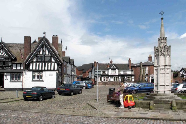


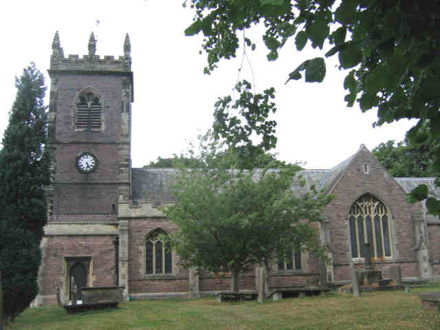
Sandbach, United Kingdom
Sandbach is a town of 17,976 people in England, United Kingdom.
Why visit Sandbach
Townapedia lists 10 museums and landmarks, 16 parks and trails, 70 places to eat and 3 places to stay in and around town.
Highlights include Sandbach Crosses and Sandbach Golf Club.
Weather in Sandbach
Forecast from MET Norway (CC BY 4.0). Full forecast
About Sandbach
Sandbach (pronounced ) is a market town and civil parish in the Cheshire East borough of Cheshire, England. The civil parish contains four settlements: Sandbach, Elworth, Ettiley Heath and Wheelock. At the 2021 census, the Sandbach built up area as defined by the Office for National Statistics had a population of 11,290 and the parish had a population of 21,916.
From the Wikipedia article Sandbach (this version), under CC BY-SA 4.0.
Travel tips from other travellers: Sandbach on Wikivoyage (CC BY-SA 4.0).
Photos of Sandbach


Museums and landmarks10



Parks, trails and playgrounds16




4 more on the map.
Restaurants and cafes70

Old Hall
Bar and pub · Pub
High Street [Newcastle Road]
Mo-Fr 10:30-23:00; Sa 10:00-23:00; Su 10:30-22:30

Barchetta Restaurant
Restaurant · Italian, Mediterranean · 1.2 mi
464 Crewe Road
Mo,Tu,Th 16:00-21:00; Su 12:00-20:00; We 12:00-21:00; Fr,Sa 12:00-22:00
Phanthong Thai
Restaurant · Thai
2-4 Crewe Road
Tu-Sa 17:30-23:00, We-Sa 12:00-15:00, Su 12:00-21:00; Mo off
Kiki’s Table
Restaurant · Pie
4 Congleton Road, Sandbach
We-Fr 16:00-23:00, Sa 12:00-01:00, Su 12:00-21:30; Mo,Tu off

The Black Cat Coffee House
Cafe · Coffee Shop
11 Welles Street, Sandbach
Mo-Fr 09:00-16:00; Sa-Su 10:00-16:00

Costa
Cafe · Coffee Shop
11-13 Hightown
Mo-Fr 06:30-18:30; Sa 07:00-18:30; Su 08:00-17:00
K2H Creative Indian Kitchen
Restaurant · Indian
3-4 George's Walk, Sandbach
Tu-Th 11:00-21:30; Fr,Sa 11:00-22:00; Su 12:30-20:30; Mo off
Kan's Oriental Restaurant
Restaurant · Chinese
1 Green Street, Sandbach
Tu-Th 17:00-21:30; Fr,Sa 17:00-22:00; Su 17:00-21:00; Mo off
58 more on the map.
Where to stay3


History
Known as Sanbec in 1086, Sondbache (also Sondebache) in 1260, and Sandbitch in the 17th–18th centuries, Sandbach derives its name from the Anglo-Saxon sand bæce, which can mean "sand stream" or "sand valley". The modern German word Bach, with a similar origin as bæce, means "brook"; thus, the meaning of Sandbach can be understood correctly in German. In Germany, there are two places and several small waterways of that name (see German disambiguation page "Sandbach").
Traces of settlement are found in Sandbach from Saxon times, when the town was called Sanbec. Little is known about the town during this period, except that it was subjected to frequent Welsh and Danish raids. The town's inhabitants were converted to Christianity in the 7th century by four priests: Cedda, Adda, Betti and Diuma. The town has an entry in the Domesday Book from 1086, at which time it was sufficiently large to need a priest and a church. The entry states:
Sanbec: Bigot de Loges. 1 hide and 1½ virgates pay tax. Land for 2 ploughs. 1 Frenchman has ½ plough, 3 slaves. 2 villagers have ½ plough. Church. Woodland. Value TRE 4s; now 8s.
Read more of the history
By the 13th century, during the reign of King John, much of the land around the township of Sandbach was owned by Richard de Sandbach who was the High Sheriff of Cheshire in 1230. Richard de Sandbach specifically owned a manor; he claimed an interest in the living of Sandbach. This claim against Earl Randle de Blundeville was unsuccessful. His son, John, however, was slightly more successful as he won an 'interest' temporarily against the Abbot of Dieulacres, only for it to be lost when it went to the King's Bench.
The manor in Sandbach passed through numerous families, including the Leghs and Radclyffes. It was eventually bought by Sir Randulph (or Randle) Crewe, who became the Lord of the Manor.
Sandbach has been a market town since 1579, when it was granted a market charter by Elizabeth I following a petition from Sir John Radclyffe of Ordsall, the largest landowner in Sandbach and the owner of Sandbach Old Hall. He then encouraged the farmers of the area to hold a market in the town on Thursdays. The charter also allowed for right to establish a Court-leet and a Court of Pied-powder. The original charter is still preserved, and can be found in Chester. The charter also granted the town the right to hold two annual fairs, which lasted for two days, and were held around Easter and early September. The Thursday market is still held outdoors on Scotch Common, and in and around the town hall.
During the 17th century, the town used to be famous for its ale:
The ale brewed at this town was formerly in great repute in London, where, about the middle of the last century, it sold for twelve-pence a bottle, but it seems to be entirely supplanted by the Dorchester beer, and the Yorkshire and Welch ales, insomuch that we do not know of any Sandbach ale being now sold in the metropolis.
And about 1621 William Webb writes that "Our ale here at Sandbach being no less famous than that [at Derby] of a true nappe".
During the Wars of the Three Kingdoms, a Scottish army swept down into England before being forced to retreat at the Battle of Worcester. On 3 September 1651, the Sandbach summer fair was being held, and a Scottish army of around 1,000 exhausted cavalry men passed through the town under the command of David Leslie on their way back to Scotland. The town proved to be a difficult retreat route, however, as the people of Sandbach and the market stallholders attacked the Scottish army. A newspaper of the time said:
The dispute was very hot for two or three houres, and there were some townsmen hurt and two or three slaine, the Townesman slew about nine or ten and tooke 100 prisoners.
This was the only notable event of the Civil War to have happened in Sandbach. As the fair and the fight took place on the common of the town, after this event the common gained the name Scotch Common.
In 1836 Sandbach silk mills employed 554 people, including 98 boys and girls under 12 years old.
Sandbach railway station opened in 1842 on the Manchester and Birmingham Railway. It lies 1.5 miles (2.4 km) west of the centre of Sandbach. When built, the station was in the neighbouring township of Elton, close to the borders with the townships of Sandbach and Bradwall. The small hamlet of Elworth adjoining the station grew significantly after the arrival of the railway. The Elworth area, including the station, was absorbed into urban district of Sandbach in 1936.
The Sandbach Corn Mill was a three-story brick building built in the late 19th century, on what is now Mill Hill Lane.
In 1933 the ERF lorry company was founded. In 1936 parts of the area of Bradwall, all of Elton and Wheelock were added, significantly increasing the size of the parish. The hamlets transferred from Bradwall were Boothlane Head, Brickhouses, Ettiley Heath, Forge Fields, Hindheath, Elworth and Marsh Green. By 1951 the population had reached 9,253.
During the Second World War, in Warship Week in December 1941 Sandbach adopted HMS Vimiera as its affiliated ship. The Vimiera was lost on 9 January 1942 when it was sunk by a mine in the Thames Estuary off East Spile Buoy with the loss of 96 hands.
From the History section of Sandbach on Wikipedia, under CC BY-SA 4.0.
More about Sandbach
Geography
The land area of Sandbach has a total coverage of 10.7 square kilometres (4.1 sq mi). The distance from London to Sandbach is 171 miles (275 km). Crewe is 6 miles (10 km) to the south-west and Stoke-on-Trent in the neighbouring Staffordshire is 15 miles (24 km).
Economy
Sandbach has been a market town since 1579 when it was granted a Royal Charter by Elizabeth I. Today the Thursday market is still held outdoors on Scotch Common, and in and around Sandbach Town Hall.
Sandbach is probably best known as the original home of both Foden and ERF lorries, both companies founded by members of the Foden family. Neither company now exists in Sandbach, having been taken over and production moved elsewhere. As of 2007 there is no trace of Fodens within Sandbach, with the former mansion home of the Foden family at Westfields being demolished to make way for a new council building. However, Foden's Brass Band, originally created for employees, is still based in Sandbach.
There is also a farmers' market which takes place on the second Saturday of each calendar month.
Sandbach lies close to the conurbations of Greater Manchester, Merseyside and The Potteries.
Arts and culture
Sandbach has an annual transport festival which usually takes place during April. It originally started in 1992 as ‘Transport Through the Ages Parade', and was such a success that it became an annual event; since its inception it has been run alongside the National Town Criers' competition. The Festival is run by an organising committee made up of local councils and volunteers.
Foden's Brass Band is still based in the town, despite the truck manufacturer from which it derives its name no longer having a presence. In 2008 Foden's became British Open Brass Band Champions. The Lions Youth Brass Band and Roberts Bakery Band are also based in the town.
Sandbach Choral Society, formerly Sandbach Voices, is a local choir that was founded in 1947 and is a registered charity. The choir's mission is to bring choral music into the community, and it regularly stages concerts, often in Sandbach Town Hall or at St Mary's Church.
Sandbach Concert Series features classical, jazz and brass music.
At the end of November every year the Christmas lights are turned on by the chairman of the town council.
Education
The following primary schools are in Sandbach Town and Civil Parish.
Sandbach School was founded as a parish charity school for boys in 1677. The school became a grammar school for boys after 1955. In 1979 the school became an independent comprehensive boys school, with charitable status, funded by Cheshire Local Education Authority but controlled by a board of governors. In September 2011, Sandbach School became a free school, one of the first free schools to be established in England. The school also contains a sixth form which is open to both boys and girls.
Within Sandbach there is also a girls comprehensive school, Sandbach High. It was originally the town's mixed secondary modern when Sandbach School served as the boys' grammar school, but has been a single-sex comprehensive since 1979. It now has a college attached to it, which accepts boys as well as girls and offers a more vocational side of education along with A levels.
1873 (Sandbach) Squadron is the local squadron of the Air Training Corps. Founded in 1952, it is part of Greater Manchester Wing, having formerly been a part of both Cheshire and Staffordshire Wings. Cadets here parade twice a week; Wednesdays and Fridays from 19:15 to 21:30. The squadron usually parades about 30–40 cadets per parade night.
24 Sandbach Detachment, Cheshire Army Cadet Force is based in the Army Cadet Centre behind the police station.
From the Wikipedia article Sandbach, under CC BY-SA 4.0.
Notable people from Sandbach
- I. A. RichardsEnglish literary critic and rhetorician (1893–1979)
- Frank RobertsEnglish footballer (1893-1961)
- Mia BrookesBritish snowboarder
- Bert SprostonEnglish footballer (1914-2000)
- A.W.B. BourneEnglish footballer
- William JamesEnglish academic and bishop
- Roland LewisFootballer (1923-1999)
- Charles KellyEnglish footballer (1894-1969)
- Shaun HollinsheadEnglish footballer (born 1961)
- Thomas HilditchEnglish cricketer (1885-1957)
- Will BordillScottish rugby union player
- R. Welldon FinnEnglish historian (1901–1971)
Born in Sandbach, according to Wikidata (CC0). Each name links to its Wikipedia article.
Churches and places of worship24
Shopping7
Gas and EV charging2
Schools, colleges and libraries9
Healthcare3
Map of Sandbach
144 places. The map loads OpenStreetMap tiles when you open it.
Getting there and nearby towns
Manchester Airport (MAN) is the nearest airport with scheduled flights listed in OpenStreetMap, 14 miles away.
- Winsford 7 mi northwest, about 12 min by car
- Newcastle under Lyme 11 mi southeast, about 18 min by car
- Stoke-on-Trent 12 mi southeast, about 20 min by car
- Wilmslow 14 mi northeast, about 22 min by car
- Timperley 18 mi north, about 28 min by car
- Whitchurch 18 mi southwest, about 29 min by car
- Warrington 19 mi northwest, about 31 min by car
- Stone 19 mi southeast, about 30 min by car
- Stockport 20 mi northeast, about 32 min by car
- Manchester 24 mi north, about 38 min by car
Drive times are estimates from straight-line distance, not routes.
Towns near Sandbach


Keep exploring
Local news
Headlines from INDB.
Reviews, tips and questions
Loading what members have shared...
Sources and licences
- GeoNames (CC BY 4.0): population, coordinates, regions and time zone
- Mapillary (see each image): photos
- OpenStreetMap contributors (ODbL 1.0): places, airports, map data
- Wikidata (CC0 1.0): elevation, founding date, time zone, website, landmarks and historic places
- Wikimedia Commons (see each image): photos
- Wikipedia (CC BY-SA 4.0): overview and history text
Photo credits
- Sandbach, www fotodiscs4u co uk, CC BY-SA 2.0
- N701DRP Rover Maestro 1.3 HL, Sandbach, kitmasterbloke, CC BY 2.0
- N701DRP Rover Maestro 1.3 HL, Sandbach. - 53678021453, kitmasterbloke, CC BY 2.0
- Sandbach Methodist Church and Sunday School, Iantresman, CC BY-SA 4.0
- Christ Church Alsager, Sep 2023, Dominic Nelson, CC BY-SA 4.0
- St Leonard's Church, Warmingham, Stephen Craven, CC BY-SA 2.0
- Holmes Chapel 1, Peter I. Vardy, Public domain
- Sandbach Mary 1, Peter I. Vardy, Public domain
- Haslington - St Matthew's Church - May 2025, Dominic Nelson, CC BY-SA 4.0
- Old Hall Hotel, Sandbach, Humphrey Bolton, CC BY-SA 2.0
- School House of Sandbach School (2), ARBAY, CC BY-SA 3.0
- VJ1476 1929 Foden Steam Ballast box wagon, kitmasterbloke, CC BY 2.0
- 3rd Scale Foden Steam Wagon, kitmasterbloke, CC BY 2.0
- BAPC377 Replica VS Spitfire LF.VIIIc, kitmasterbloke, CC BY 2.0
- AF4442 1921 Aveling & Porter Road Roller, 8548 "Britannia", kitmasterbloke, CC BY 2.0
- BAPC377 Replica VS Spitfire LF.VIIIc - 53676931597, kitmasterbloke, CC BY 2.0
- BAPC377 Replica VS Spitfire LF.VIIIc - 53678160944, kitmasterbloke, CC BY 2.0
- PSY722 Land Rover Series 1, kitmasterbloke, CC BY 2.0
- 250YUS 1953 Citroen Avant, kitmasterbloke, CC BY 2.0
- SSU954 1961 MG A 1600, kitmasterbloke, CC BY 2.0
- ACC101A 1955 Standard 10 SAloon, kitmasterbloke, CC BY 2.0
- Coronation tree plaque in Sandbach Park 6 May 1935, Iantresman, CC BY-SA 3.0
- Canal milepost east of Wheelock Wharf, Dave.Dunford, CC BY-SA 4.0
- Street-level photo, mapillarygelec, CC BY-SA 4.0
- Street-level photo, mapillarygelec, CC BY-SA 4.0
- Street-level photo, mapillarygelec, CC BY-SA 4.0
- Street-level photo, mapillarygelec, CC BY-SA 4.0


Page built November 10, 2026. Spotted a mistake? Tell us or suggest a place.