
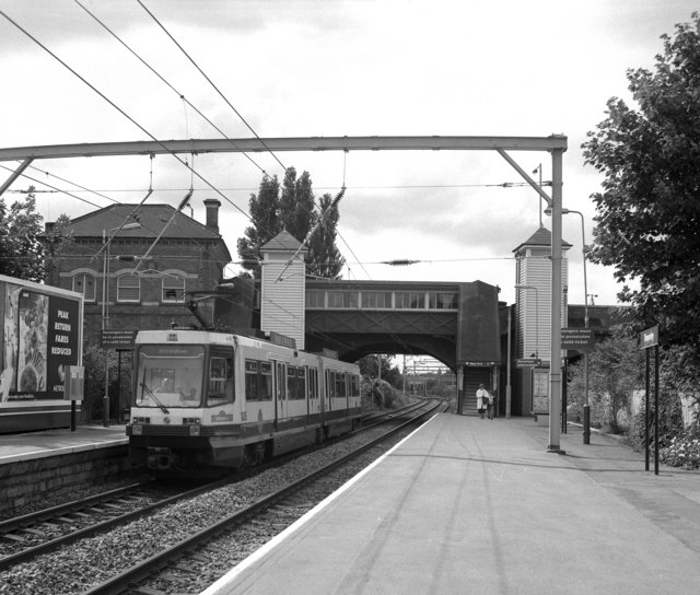


Timperley, United Kingdom
Timperley is a town of 11,323 people in England, United Kingdom.
Why visit Timperley
Townapedia lists 10 museums and landmarks, 47 parks and trails, 153 places to eat, 6 places to stay and 5 attractions in and around town.
Highlights include Altrincham Garrick, Everyman Altrincham, Dunham Massey Hall and Watch Hill Castle.
Weather in Timperley
Forecast from MET Norway (CC BY 4.0). Full forecast
About Timperley
Timperley is a suburban area in the borough of Trafford, in Greater Manchester, England. Within the boundaries of the historic county of Cheshire, it lies approximately 6 miles (10 km) south-west of central Manchester. The population at the 2021 census was 11,323.
From the Wikipedia article Timperley (this version), under CC BY-SA 4.0.
Things to do5

Altrincham Garrick
Cinema and theater · 0.8 mi
Theatre in Altrincham, Greater Manchester, England
Museums and landmarks10

Dunham Massey Hall
Museum · 3.0 mi
Grade I listed building in Trafford, Greater Manchester, England, UK

Watch Hill Castle
Monument and historic site · 2.8 mi
Medieval castle in Bowdon, Greater Manchester, England, UK


Timperley Old Hall Moated Site
Monument and historic site · 0.7 mi
Moated walled garden comprising original site of mediaeval Timperley Old Hall.

Gravestone of Richard Pankhurst (husband of Suffragette leader Emily Pankhurst)
Monument and historic site · 1.3 mi
Parks, trails and playgrounds47


Sale Water Park
Park · 2.6 mi
Public park in Sale Moor, Greater Manchester



Black Moss Covert Nature Reserve
Park · 2.1 mi
Nature reserve in Greater Manchester, England

Pitch and Putt
Golf course · 1.1 mi
Kenmore Road
Su-Sa,PH 10:30-18:30 "(last tee Spring/Summer time) Autumn/Winter...

35 more on the map.
Restaurants and cafes153

Asda Café
Cafe · Coffee Shop · 1.3 mi
90 George Richards Way, Altrincham
Mo-Sa 08:30-18:00; Su 10:00-16:00

Gonbay
Restaurant · Cantonese · 1.2 mi
8 Brooklands Station Approach, Sale
Mo 10:30-22:00; We-Fr 10:30-22:00; Sa 10:30-23:00; Su 10:30-22:00
Caffè Nero
Cafe · Coffee Shop · 1.1 mi
Shaw's Road, Altrincham
Mo-Fr 07:30-18:00; Sa 07:30-18:30; Su 08:00-17:30

Gardeners Arms
Bar and pub · 0.4 mi
41 Deansgate Lane, Altrincham
Mo-Th 11:30-23:00; Fr 11:30-00:00; Sa 10:00-00:00; Su 10:00-23:00
Kickback Coffee
Cafe · Coffee Shop · 0.6 mi
4 Viaduct Road, Altrincham
Mo-Fr 08:00-15:00; Sa-Su 09:00-16:00

Stubborn Mule Brewery and Tap
Brewery and winery · 0.4 mi
1 Skelton Road, Altrincham
Fr 16:00-21:00; Sa 14:00-21:00
141 more on the map.
History
The name Timperley derives from Timber Leah, the Anglo-Saxon (Old English) for a "clearing in the forest"; this can be used to roughly date the settlement of Timperley to between the 7th and 8th centuries. It was a predominantly agricultural settlement before the Industrial Revolution, focusing mainly on arable crops.
The Bridgewater Canal branch from Stretford to Runcorn was built through Timperley and opened in 1776. This improvement in transport encouraged the development of market gardening in the area to serve the growing city of Manchester. The city also provided a source of night soil, which was unloaded from the canal by Deansgate Lane to provide manure for farms and market gardens.
During the mid-19th century, four railways were built in Timperley:
The Manchester, South Junction and Altrincham Railway (MSJAR) opened in 1849, with a station in Timperley on Wash Lane (now Park Road).
The Warrington and Stockport Railway (W&SR) opened in 1854 from Timperley Junction, just south of the station on the MSJAR. It became part of the London and North Western Railway (LNWR) in 1859.
Timperley curve was built in 1879 by the Manchester, Sheffield and Lincolnshire Railway (MS&LR) linking Skelton Junction with Timperley Junction.
Read more of the history
The Stockport, Timperley and Altrincham Junction Railway was built through Timperley to link with the now LNWR W&S at Broadheath Junction opening in February 1866 and, from Skelton Junction, to link with the MSJAR at Deansgate Junction opening in December 1865. This became part of the Cheshire Lines Committee (CLC). Baguley station also served the area on this line.
The CLC line (often referred to as the West Timperley line) from Skelton Junction to Glazebrook was opened in 1873. West Timperley station on this line was actually in Broadheath. The arrival of the railways brought the middle classes from the centre of Manchester and this is reflected by the increase of numbers in domestic services in Timperley at the same time. The impact of the railway can be seen in Timperley's population between 1851 and 1871, which more than doubled from 1,008 to 2,112.
In 1931, the MSJAR line was electrified; it was one of the first railway lines in Great Britain to use supply by overhead cables. A large electrical substation was built in connection with this, just south of Timperley station.
The line was converted to light rail in 1992, forming part of Manchester Metrolink.
From the History section of Timperley on Wikipedia, under CC BY-SA 4.0.
More about Timperley
Geography
Timperley lies to the north-east of Altrincham; it is bounded by Fairywell Brook to the east, Hale Moss and Well Green to the south, Timperley Brook to the west, and Baguley Brook to the north.
It has borders with the areas of Altrincham to the south, Sale to the north and the City of Manchester suburb of Wythenshawe to the east.
Village - the main focal point, at the junction of Stockport Road/Thorley Lane/Park Road
West Timperley - north-west from the Metrolink station towards Manchester Road
Timperley Heyes - to the north, covering Grange Estate, Heyes Lane and Riddings
Higher Timperley - area to the south-west, bounded by Thorley Lane/Wood Lane
Timperley was struck by an F0/T1 tornado on 23 November 1981, as part of the record-breaking nationwide tornado outbreak on that day.
Economy
At the 2021 UK census, Timperley had a low rate of unemployment (1.8%), compared with Trafford (2.6%) and England (3.4%). People living in Timperley were also typically close to their workplace, with 42.5% mainly working from home and 34.5% being fewer than 6.2 miles (10 km) from where they work.
According to the 2001 UK census, the industry of employment of residents in Timperley was 17.8% property and business services, 16.2% retail and wholesale, 11.9% manufacturing, 11.2% health and social work, 8.6% education, 8.0% transport and communications, 6.4% finance, 6.0% construction, 4.3% public administration and defence, 3.6% hotels and restaurants, 0.9% energy and water supply, 0.6% agriculture, and 4.2% other.
Arts and culture
The South Trafford Archaeological Group (STAG) was formed in 1979, which provides facilities for volunteer archaeologists from south Manchester and north-east Cheshire. The group is based near Timperley Old Hall and the clubhouse of the Altrincham Municipal Golf Course. STAG have been involved with sites such as Carrs Mill in Stalybridge, Moss Brow farm in Warburton, Moore's hat factory in Denton, the medieval hall in Urmston and the medieval moated site of Timperley Old Hall.
Since 1984, Timperley has held a country fair every September on the open ground of Lark Hill, by Thorley Lane. It has a variety of art, craft and charity stalls, all organised by a small committee of local residents.
The Altrincham and District Astronomical Society meets ten times a year.
Education
Brentwood School and Pictor School are special schools in Timperley, while Forest School is a private school.
Trafford College has a campus in West Timperley, offering further education to students from across the borough.
From the Wikipedia article Timperley, under CC BY-SA 4.0.
Notable people from Timperley
 George EdmundsonEnglish association football player (born 1997)Photo: Timmy96, CC0
- Agnes PochinEnglish campaigner for women's rights
- Patrick BriggsEnglish cricketer and rugby union footballer (born 1940)
- Peter GoochEnglish cricketer (born 1949)
- Donald ShawBritish rower
- John ThompsonCanadian poet from England, born 1938
- Kenneth FisherBritish educationalist (1882-1945), headmaster at Oundle School from 1922 to 1945
- Howard Whitefootballer
Born in Timperley, according to Wikidata (CC0). Each name links to its Wikipedia article.
Where to stay6
Churches and places of worship33
Shopping29
Gas and EV charging9
Schools, colleges and libraries39
Healthcare14
Map of Timperley
250 places. The map loads OpenStreetMap tiles when you open it.
Getting there and nearby towns
Manchester Airport (MAN) is the nearest airport with scheduled flights listed in OpenStreetMap, 4 miles away.
- Salford 6 mi north, about 10 min by car
- Manchester 7 mi northeast, about 11 min by car
- Wilmslow 7 mi southeast, about 10 min by car
- Stockport 7 mi east, about 12 min by car
- Warrington 10 mi west, about 16 min by car
- Whitefield 10 mi north, about 17 min by car
- Oldham 13 mi northeast, about 21 min by car
- Bolton 13 mi north, about 21 min by car
- Westhoughton 13 mi northwest, about 21 min by car
- Wigan 16 mi northwest, about 26 min by car
Drive times are estimates from straight-line distance, not routes.
Towns near Timperley


Keep exploring
Local news
Headlines from INDB.
Reviews, tips and questions
Loading what members have shared...
Sources and licences
- GeoNames (CC BY 4.0): population, coordinates, regions and time zone
- Mapillary (see each image): photos
- OpenStreetMap contributors (ODbL 1.0): places, airports, map data
- Wikidata (CC0 1.0): elevation, founding date, time zone, website, landmarks and historic places
- Wikimedia Commons (see each image): photos
- Wikipedia (CC BY-SA 4.0): overview and history text
Photo credits
- Timperley metrolink station 1993, Dr Neil Clifton, CC BY-SA 2.0
- Dunham Massey 2015 105, Photograph by Mike Peel ( www.mikepeel.net )., CC BY-SA 4.0
- Watch Hill Castle, 2009, Richard Nevell, CC BY-SA 4.0
- Birch Moss covert, Parrot of Doom, CC BY-SA 3.0
- SaleWaterPark640, Malleus Fatuorum at en.wikipedia, Public domain
- St Margaret’s Church Dunham Rd Altrincham, ArcLight, CC BY-SA 3.0
- St Mary's Church, Bowdon, David Long, CC BY-SA 2.0
- St Elizabeth's Church, Ashley 02, Dave.Dunford, CC BY-SA 4.0
- Stgeorgeschurch, Dave Smethurst, CC BY-SA 2.0
- St martins ashton upon mersey, Parrot of Doom, CC BY-SA 3.0
- Moss Lane, Jimbo online at English Wikipedia, Public domain
- Icedomeinterior, LearnedRobb, CC BY-SA 3.0
- Frank Sidebottom statue Timperley Manchester, Duncan.Hull, CC BY-SA 3.0
- Walkden Gardens, The Dovecote - panoramio, deepeye, CC BY-SA 3.0
- Street-level photo, southglos, CC BY-SA 4.0
- Street-level photo, southglos, CC BY-SA 4.0
- Street-level photo, southglos, CC BY-SA 4.0
- Street-level photo, southglos, CC BY-SA 4.0
- Street-level photo, julianlb, CC BY-SA 4.0
- Street-level photo, julianlb, CC BY-SA 4.0


Page built November 10, 2026. Spotted a mistake? Tell us or suggest a place.