




Stoke-on-Trent, United Kingdom
Stoke-on-Trent is a city of 258,366 people in England, United Kingdom, founded in 1925.
Why visit Stoke-on-Trent
Townapedia lists 75 museums and landmarks, 71 parks and trails, 144 places to eat, 24 places to stay and 29 attractions in and around town.
Highlights include New Victoria Theatre, Queen's Theatre, Ford Green Hall and Brampton Museum.
Weather in Stoke-on-Trent
Forecast from MET Norway (CC BY 4.0). Full forecast
About Stoke-on-Trent
Stoke-on-Trent, often known as Stoke, is a city and unitary authority area in Staffordshire, England. It had an estimated population of 259,965 in 2022, making it the largest settlement in Staffordshire and one of the largest cities of the Midlands. Stoke is surrounded by the towns of Alsager, Biddulph, Cheadle, Kidsgrove, Newcastle-under-Lyme and Stone, which form a conurbation around the city.
From the Wikipedia article Stoke-on-Trent (this version), under CC BY-SA 4.0.
Travel tips from other travellers: Stoke-on-Trent on Wikivoyage (CC BY-SA 4.0).
Photos of Stoke-on-Trent


Things to do29


Queen's Theatre
Cinema and theater · 3.0 mi
Music venue and theatre in Burslem, Stoke-on-Trent, England; built as town hall and theatre
Wedgwood Street, Stoke-on-Trent

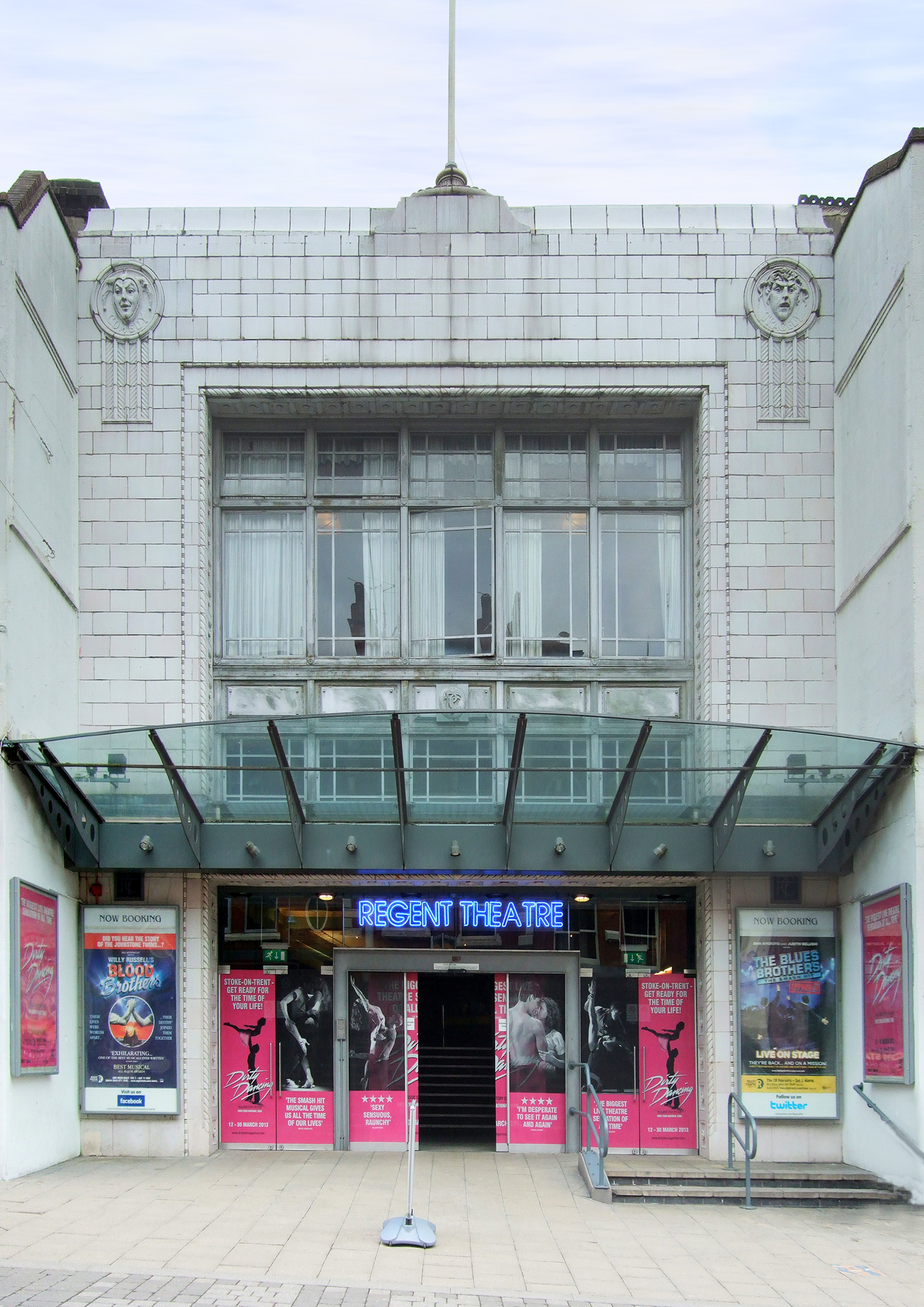
Regent Theatre
Cinema and theater · 1.4 mi
Theatre and former cinema in Stoke-on-Trent, England
Piccadilly, Stoke-on-Trent
New Vic Theatre
Cinema and theater · 1.5 mi
Theatre in Newcastle-under-Lyme, England

Repertory Theatre, Stoke-on-Trent
Cinema and theater · 0.8 mi
Theatre in Leek Road, Stoke-on-Trent, England


Empire Theatre
Cinema and theater · 2.4 mi
Former theatre in Stoke-on-Trent, England, later used as a bingo hall
Gaumont Stoke-on-Trent
Cinema and theater
Former cinema in Stoke-on-Trent, England
Theatre Royal, Hanley
Cinema and theater · 1.5 mi
Former theatre in Hanley, Stoke-on-Trent, England, now a pub
Victoria Hall
Cinema and theater · 1.4 mi
Bagnall Street, Stoke-on-Trent
17 more on the map.
Museums and landmarks75

Ford Green Hall
Museum · 3.6 mi
Farmhouse and museum in Stoke-on-Trent, Staffordshire, England, UK
Ford Green Road, Stoke-on-Trent
Mo-Th, Su 13:00-16:00


Gladstone Pottery Museum
Museum · 2.6 mi
Industrial museum in Staffordshire, England
Uttoxeter Road, Stoke-on-Trent

Potteries Museum and Art Gallery
Museum · 1.3 mi
Bethesda Street, Stoke-on-Trent
We-Sa 10:00-17:00; Su 11:00-16:00



Etruria Industrial Museum
Museum · 1.0 mi
Museum in Staffordshire, England, United Kingdom
Etruria Vale Road, Stoke-on-Trent
Burslem United Reformed Church (Formerly Woodall Memorial Congregational Church)
Monument and historic site · 2.9 mi
Memorial in Stoke-on-Trent, Staffordshire, England, UK
63 more on the map.
Parks, trails and playgrounds71


Burslem Park
Park · 3.1 mi
Park in Stoke-on-Trent, Staffordshire, England, UK

Bathpool Park
Park · 5.6 mi
Park in Kidsgrove, Staffordshire, England, UK

Victoria Park
Park · 4.0 mi
Park in Stoke-on-Trent, Staffordshire, England, UK

Apedale Community Country Park
Park · 4.1 mi
Country park in Staffordshire, England
59 more on the map.
Restaurants and cafes144

Greyhound Inn
Bar and pub · 0.5 mi
6 Manor Court Street, Stoke-on-Trent
Mo-We 12:00-23:00; Th-Sa 12:00-24:00, Su 12:00-23:00

Amore
Restaurant · Italian · 1.9 mi
5 Pepper Street, Newcastle-under-Lyme
Th-Fr 18:00-24:00; Sa 12:00-24:00
Anasma Greek Bakery
Restaurant · Greek, Pastry · 1.8 mi
7 Queens Parade, Newcastle-under-Lyme
Tu-Sa 10:00-20:00
Art of Siam
Restaurant · Thai · 1.9 mi
30-32 High Street, Newcastle-under-Lyme
Mo off; Tu 17:00-22:30; We-Th 12:00-14:30, 17:00-22:30; Fr-Sa...
Asha Tandoori
Restaurant · Indian · 2.0 mi
22A Higherland, Newcastle-under-Lyme
Mo-Th,Su 17:00-23:30; Fr-Sa 17:00-24:00
Basmati Restaurant
Restaurant · Indian · 1.6 mi
13 Brunswick Street, Newcastle-under-Lyme
Mo-Th,Su 18:00-23:00; Fr-Sa 18:00-23:30
Bauhinia
Restaurant · Chinese · 1.2 mi
2 Lyme Drive, Stoke-on-Trent
Tu-Th 17:30-22:30; Fr-Sa 12:00-15:00, 17:30-23:00; Su 12:00-22:30
Breeze Bowls
Restaurant · Smoothie, Coffee Shop, Acai, Matcha, Brazilian · 1.8 mi
52 Ironmarket, Newcastle-under-Lyme
Mo-Fr 09:00-17:00; Sa 09:00-16:30; Su 09:00-16:00

Caffe Java
Cafe · Coffee Shop, Tea, Sandwich · 1.8 mi
24 Ironmarket, Newcastle-under-Lyme
Mo-Sa 09:00-16:30; Su 10:30-15:30
Cappello Lounge
Cafe · Coffee Shop, Tea · 1.8 mi
57-58 Ironmarket, Newcastle-under-Lyme
Mo-Th,Su 09:00-22:00; Fr-Sa 09:00-23:00
Hole In The Wall Oatcakes
Restaurant · Breakfast · 1.0 mi
Unit D2 Dewsbury Road, Stoke-on-Trent
Mo,We-Fr 07:00-12:45
132 more on the map.
History
An early proposal for a federation took place in 1888 when an amendment was raised to the Local Government Bill which would have made the six towns into districts within a county of Staffordshire Potteries. On 1 April 1910 the "Six Towns" were brought together. The county borough of Hanley, the municipal boroughs of Burslem, Longton, and Stoke, together with the urban districts of Tunstall and Fenton now formed a single county borough of Stoke-on-Trent.
In 1919, the borough proposed to expand further and annex the neighbouring borough of Newcastle-under-Lyme and the Wolstanton United Urban District, both to the west of Stoke. This never took place, due to strong objections from Newcastle Corporation. A further attempt was made in 1930, with the promotion of the Stoke-on-Trent Extension Bill. Ultimately, Wolstanton was instead added to Newcastle-under-Lyme in 1932. Although attempts to merge Newcastle, Wolstanton and Kidsgrove (north of Tunstall) were never successful, the borough expanded in 1922, taking in Smallthorne Urban District and parts of other parishes from Stoke upon Trent Rural District.
Read more of the history
The borough was granted city status in 1925, with a lord mayor from 1928. When the county borough of Stoke-on-Trent initially applied for city status in 1925, citing its importance as the centre of the pottery industry, it was refused by the Home Office as it had fewer than 300,000 inhabitants. The decision was overturned, when a direct approach was made to King George V, who agreed that the borough ought to be a city. The public announcement of the elevation to city status was made by the king during a visit to Stoke in June 1925.
The county borough was abolished in 1974. Stoke became a non-metropolitan district of Staffordshire; its status as a unitary authority was restored in April 1997. It remains part of the ceremonial county of Staffordshire. For Eurostat purposes it is a ITL 3 region (code TLG31).
Under current local government reorganisation plans, the current unitary authority of Stoke-on-Trent, along with all district councils in Staffordshire, as well as the county council, will be abolished in 2028, with the area forming part of a new North Staffordshire unitary authority, along with the two-tier districts of Newcastle-under-Lyme and Staffordshire Moorlands. It is planned that charter trustees will be used to continue Stoke-on-Trent's city status, and mayoralty.
Since the 17th century, the area has been almost exclusively known for its industrial-scale pottery manufacturing. Companies such as Royal Doulton, Dudson, Spode (founded by Josiah Spode), Wedgwood (founded by Josiah Wedgwood), Minton (founded by Thomas Minton) and Baker & Co. (founded by William Baker) were established and based there. The local abundance of coal and clay suitable for earthenware production led to the early (initially limited) development of the local pottery industry. The construction of the Trent and Mersey Canal (completed in 1777) enabled the import of china clay from Cornwall together with other materials and facilitated the production of creamware and bone china.
Other production centres in Britain, Europe and worldwide had a considerable lead in the production of high-quality wares. Methodical and highly detailed research and experimentation, carried out over many years, nurtured the development of artistic talent throughout the local community and raised the profile of Staffordshire Potteries. This was spearheaded by one man, Josiah Wedgwood, who cut the first sod for the canal in 1766 and erected his Etruria Works that year.
Wedgwood built upon the successes of earlier local potters such as his mentor Thomas Whieldon and along with scientists and engineers, raised the pottery business to a new level. Josiah Spode introduced bone china at Trent in 1796 and Thomas Minton opened his manufactory. With the industry came a large number of notable 20th-century ceramic artists including Clarice Cliff, Susie Cooper, Charlotte Rhead, Frederick Hurten Rhead and Jabez Vodrey.
North Staffordshire was a centre for coal mining. The first reports of coal mining in the area come from the 13th century. The Potteries Coalfield (part of the North Staffordshire Coalfield) covers 100 square miles (300 km2).
Striking coal miners in the Hanley and Longton area ignited the nationwide 1842 general strike and its associated Pottery Riots.
When coal mining was nationalised in 1947, about 20,000 men worked in the industry in Stoke-on-Trent. Notable collieries included Hanley Deep Pit, Trentham Superpit (formerly Hem Heath, Stafford and Florence Collieries), Fenton Glebe, Silverdale, Victoria, Mossfield, Parkhall, Norton, Chatterley Whitfield and Wolstanton. The industry developed greatly and new investments in mining projects were planned within the City boundaries as recently as the 1990s. However, 1994 saw the last pit to close as the Trentham Superpit was shut.
The Stoke mining industry set several national and international records. Wolstanton Colliery, when modernised, had the deepest mining shafts in Europe at 3,197 ft. In 1933, Chatterley Whitfield Colliery became the first Colliery in the country to mine one million tons of coal. In the 1980s, Florence Colliery in Longton repeatedly set regional and national production records; in 1992, the combined Trentham Superpit (Hem Heath and Florence) was the first mine in Europe to produce 2.5 million saleable tonnes of coal.
From the History section of Stoke-on-Trent on Wikipedia, under CC BY-SA 4.0.
More about Stoke-on-Trent
Geography
Stoke-on-Trent has an area of 36 square miles (93 km2). It is located between Manchester to the north and Wolverhampton and Birmingham to the south on the M6 corridor in the West Midlands region. It lies on the upper valley of the River Trent at the south-west foothills of the Pennines, near the uplands of the Peak District to the north-east and the lowlands of the Midlands and Cheshire Plain to the south and west. The city ranges from 92 to 250 metres (301 to 820 ft) above sea level.
As well as Newcastle-under-Lyme, which adjoins it to the west, other nearby towns include Crewe, Nantwich, Alsager, Congleton, Biddulph, Kidsgrove, Stafford, Uttoxeter, Eccleshall, Cheadle, Stone and Leek.
Stoke-on-Trent is often known as "the city of five towns", the name given to it by local novelist Arnold Bennett, and is the only polycentric city in the UK. In his novels, Bennett used mostly recognisable aliases for five of the six towns, although he called Stoke "Knype". Bennett said that he believed "Five Towns" was more euphonious than "Six Towns", so he omitted Fenton, now sometimes referred to as "the forgotten town." As it is a city made up of multiple towns, the city forms a conurbation. In this case, the conurbation is bigger than Stoke itself, because the urban area of Stoke is contiguous with that of administratively separate Newcastle.
Economy
Stoke-on-Trent was a world centre for fine ceramics; a skilled design trade has existed in the area since at least the 12th century. In the late 1980s and 1990s, Stoke-on-Trent was hit hard by the general decline in the British manufacturing sector. Numerous factories, steelworks, collieries and potteries were closed, including the renowned Shelton Bar steelworks. This resulted in a sharp rise in unemployment in the 'high-skilled but low-paid' workforce.
The pottery firm Wedgwood and its subsidiary Royal Doulton are based nearby Barlaston, although much production now takes place in the firm's Indonesian factory. Portmeirion is based in Stoke town, and now owns the Spode and Royal Worcester ceramics brands. Ceramics firm Emma Bridgewater is based in Hanley. Burleigh Pottery is in Middleport. Wade Ceramics is in Etruria.
Moorcroft and Royal Stafford are based in Burslem. Aynsley China is in Longton and is one of the last remaining manufacturers of bone china in the city. Fine china manufacturer Dudson have premises in Hanley and Burslem. Churchill China have their main factory in Tunstall. Hotelware manufacturer Steelite is based in Middleport at the former Dunn Bennett site.
Arts and culture
The architecture of North Staffordshire has a history expressive of locally acquired or manufactured building materials, including: quarried stone, coal and clay for brick and tile-making, ash, sand gravel and cement for concrete; and also cast iron steel and timber. Examples include:
The 18th-century canal-side Wedgwood estate of Etruria Works, one of the hubs of the Industrial Revolution
The expansion and renewal of industrial, civic and amenity buildings, including the Potteries Museum and Art Gallery.
Stoke-on-Trent's architecture is tied closely to the industrial heritage of the city. Bottle ovens (used for early pottery manufacture), canal-side and railway-related mill, factory or warehouse buildings evolved – within the tightly knit street pattern of each of the six townships – from transport links and adjacency to local generationally skilled labour. Post-WWII pottery factories developed a style typified by open-plan manufacturing areas, surrounded by wide expanses of window-walling from floor to ceiling, allowing good daylighting for intricate tasks such as lithography, fettling and decoration.
Education
There are four further and higher education institutions in the local area, the two further education colleges being City of Stoke-on-Trent Sixth Form College and Stoke-on-Trent College. Formerly of Fenton, now located in a newly built structure on Leek Road, the Sixth Form College provides A Level teaching for around 1,800 students. Stoke-on-Trent College is much larger and less specialised, offering apprenticeships and adult education; it has a main campus (Cauldon Campus) in Shelton and a secondary campus in Burslem.
The city is home to University of Staffordshire, formerly North Staffordshire Polytechnic, with its main site in Shelton, near Stoke-on-Trent railway station. It gained its university status in 1992 as one of the post-1992 universities. Keele University School of Medicine uses facilities at the Royal Stoke University Hospital in Hartshill. Keele University was founded as the University College of North Staffordshire in 1949 with major involvement by Stoke-on-Trent City Council. It is located in the nearby village of Keele.
From the Wikipedia article Stoke-on-Trent, under CC BY-SA 4.0.
Notable people from Stoke-on-Trent
 Robbie WilliamsBritish singer (born 1974)Photo: Kevin Payravi, CC BY-SA 4.0
 SlashBritish musician (born 1965)Photo: Kreepin Deth, CC BY-SA 4.0
 Hugh DancyEnglish actor (born 1975)Photo: JaceMerlyn, CC BY 4.0
 Oliver LodgeEnglish physicist (1851-1940)Photo: Lafayette Ltd., CC BY 4.0
 Dinah CraikBritish novelist and poet (1826–1887)Photo: Hubert von Herkomer, Public domain
 Adrian RawlinsEnglish actorPhoto: YanRB, CC BY-SA 4.0
 Dennis WilshawEnglish footballer (1926–2004)Photo: Eskil Malmberg, Public domain
 Billy HowleBritish actorPhoto: Danielle G. Campbell, CC BY-SA 4.0
- Aaron RamsdaleEnglish association football player (born 1998)
- Phil TaylorEnglish darts player (born 1960)
- William AstburyBritish biochemist (1898-1961)
- Havergal BrianBritish composer (1876–1972)
Born in Stoke-on-Trent, according to Wikidata (CC0). Each name links to its Wikipedia article.
Where to stay24
Best Western Stoke-on-Trent City Centre Hotel
Motel and hotel · 1.5 mi
66 Trinity Street, Stoke-on-Trent
Churches and places of worship55
Shopping70
Gas and EV charging36
Schools, colleges and libraries37
Hanley St Luke's Church of England Academy
School · Anglican · 1.6 mi
Wellington Road, Stoke-on-Trent
Our Lady and St Benedict Catholic Academy
School · Roman Catholic · 2.6 mi
Abbey Lane, Stoke-on-Trent
St George and St Martin's Catholic Academy
School · Roman Catholic · 2.2 mi
Boulton Street, Stoke-on-Trent
Healthcare36
Map of Stoke-on-Trent
250 places. The map loads OpenStreetMap tiles when you open it.
Getting there and nearby towns
Manchester Airport (MAN) is the nearest airport with scheduled flights listed in OpenStreetMap, 24 miles away.
- Basford, Stoke-on-Trent 1 mi northwest, about 2 min by car
- Newcastle under Lyme 2 mi west, about 3 min by car
- Wolverhampton 29 mi south, about 47 min by car
- Walsall 30 mi south, about 49 min by car
- Warrington 31 mi northwest, about 51 min by car
- Sutton Coldfield 34 mi southeast, about 55 min by car
- West Bromwich 34 mi south, about 55 min by car
- Birmingham 38 mi south, about 1 h by car
- Wigan 42 mi northwest, about 1 h by car
- Wakefield 55 mi northeast, about 1 h 30 min by car
Drive times are estimates from straight-line distance, not routes.
Towns near Stoke-on-Trent


Keep exploring
Local news
Headlines from INDB.
Reviews, tips and questions
Loading what members have shared...
Sources and licences
- GeoNames (CC BY 4.0): population, coordinates, regions and time zone
- Mapillary (see each image): photos
- OpenStreetMap contributors (ODbL 1.0): places, airports, map data
- Wikidata (CC0 1.0): elevation, founding date, time zone, website, landmarks and historic places
- Wikimedia Commons (see each image): photos
- Wikipedia (CC BY-SA 4.0): overview and history text
Photo credits
- Stoke-on-Trent montage, nagualdesign, CC BY-SA 3.0
- The Queens Theatre, Burslem, Rept0n1x, CC BY-SA 2.0
- Regent Theatre, Stoke-on-Trent, Futurilla, CC BY 2.0
- Stoke-on-Trent Repertory Theatre, Rept0n1x, CC BY-SA 2.0
- Ford Green Hall framed by tree, Nina Richards, CC BY-SA 4.0
- Bottle Kiln, MartynDavies, CC BY-SA 3.0
- Pavilion in Burslem Park, AtticTapestry, CC BY-SA 4.0
- Rugby pitch at Bathpool - panoramio, Andrew Woodvine (awo…, CC BY 3.0
- Boating lake in Victoria Park, Tunstall, AtticTapestry, CC BY-SA 4.0
- Christ Church, Fenton, from south-east, AtticTapestry, CC BY-SA 4.0
- St Paul's Church, Burslem 2, AtticTapestry, CC BY-SA 4.0
- All Saints, Madeley 1, AtticTapestry, CC BY-SA 4.0
- Bethesda, Stoke-on-Trent 2, Exterior Frontage, Stepped, CC BY-SA 3.0
- Aerial view of Bet 365 Stadium, Gkbediako, CC BY-SA 4.0
- Potteries museum & art gallery, Leereyno at English Wikipedia, CC BY-SA 3.0
- Royal Stoke University Hospital from above, Gkbediako, CC BY-SA 4.0
- At Trentham Estate 2022 080, Photograph by Mike Peel ( www.mikepeel.net )., CC BY-SA 4.0
- North Stafford Hotel, Stoke-on-Trent, Rept0n1x, CC BY-SA 3.0
- St Margaret's Church Spire 2004, User:Barlow, CC BY 2.5
- Trentham Gardens in 2018, Martyn Wright, CC BY 2.0
- New Vic Theater newcastle under lyme, Geni, CC BY-SA 4.0
- BritishCeramicsBiennial2021,SpodeRoseGarden-JennyHarper-14, Jenny Harper, CC BY-SA 4.0
- The Brampton Museum and Art Gallery - panoramio, Andrew Woodvine (awo…, CC BY 3.0
- Middleport Pottery - panoramio, Andrew Woodvine (awo…, CC BY 3.0
- Street-level photo, swinetown, CC BY-SA 4.0
- Street-level photo, adam2, CC BY-SA 4.0
- Street-level photo, adam2, CC BY-SA 4.0
- Street-level photo, mfk, CC BY-SA 4.0


Page built November 10, 2026. Spotted a mistake? Tell us or suggest a place.