


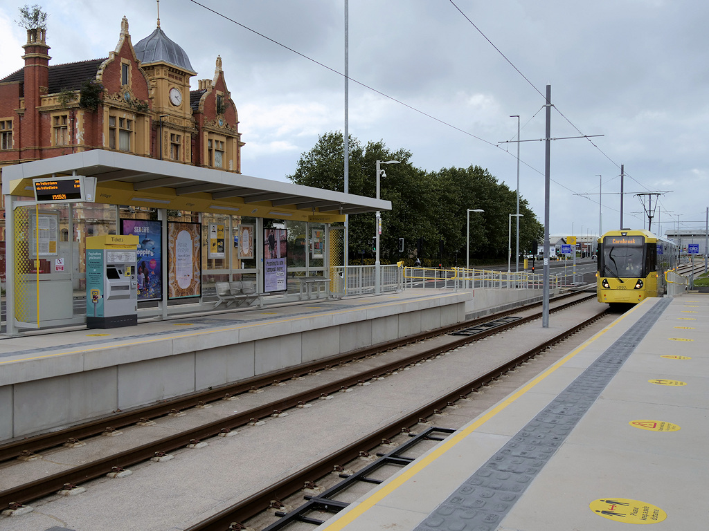


Trafford Park, United Kingdom
Trafford Park is a town of 3,060 people in England, United Kingdom.
Why visit Trafford Park
Townapedia lists 44 museums and landmarks, 31 parks and trails, 252 places to eat, 17 places to stay and 26 attractions in and around town.
Highlights include Albert Bridge, Blackfriars Bridge, Ordsall Hall and Imperial War Museum North.
Weather in Trafford Park
Forecast from MET Norway (CC BY 4.0). Full forecast
About Trafford Park
Trafford Park is an area of the metropolitan borough of Trafford, Greater Manchester, England, opposite Salford Quays on the southern side of the Manchester Ship Canal, 3.4 miles (5.5 km) southwest of Manchester city centre and 1.3 miles (2.1 km) north of Stretford. Until the late 19th century it was the ancestral home of the Trafford family, who sold it to the financier Ernest Terah Hooley in 1896. Occupying an area of 4.7 square miles (12 km2), it was the first planned industrial estate in the world, and remained the largest in Europe over a century later.
From the Wikipedia article Trafford Park (this version), under CC BY-SA 4.0.
Things to do26

Albert Bridge
Bridge · 2.6 mi
Bridge in Greater Manchester, United Kingdom

Blackfriars Bridge
Bridge · 2.8 mi
19th-century bridge in Greater Manchester, United Kingdom


Contact Theatre
Cinema and theater · 3.3 mi
Theatre in Manchester, England

Dancehouse Theatre
Cinema and theater · 3.0 mi
Dance theatre in Manchester, England, formerly a cinema

Gaiety Theatre, Manchester
Cinema and theater · 2.8 mi
Former theatre in Manchester, England (1884-1959)

Granada Studios Tour
Monument and historic site · 2.3 mi
Former theme park in Manchester, UK


HOME
Cinema and theater · 2.7 mi
Art centre for international contemporary art, theatre and film in Manchester, England

Hulme Arch Bridge
Bridge · 2.7 mi
Bridge in Hulme, Manchester, England

Hulme Hippodrome
Cinema and theater · 2.6 mi
Theatre in Hulme, Manchester, England

Corporation Street Bridge
Bridge · 3.0 mi
Covered footbridge which crosses Corporation Street in Manchester city center, England
14 more on the map.
Museums and landmarks44

Ordsall Hall
Monument and historic site · 1.4 mi
Grade I listed English country house museum in Ordsall, Greater Manchester, United Kingdom
322 Ordsall Lane, Salford
Mo-Th 10:00-16:00; Su 13:00-16:00

Imperial War Museum North
Museum · 0.5 mi
Military museum in Manchester, England
Trafford Wharf Road, Manchester
Mo-Su 10:00-17:00; Dec 24-26 off

The Lowry
Museum · 0.7 mi
Arts centre and museum in Salford, England, United Kingdom
Pier 8 The Quays, Salford

Alan Turing Memorial
Monument and historic site · 3.2 mi
Memorial in Manchester, England

British Muslim Heritage Centre
Museum · 2.4 mi
Grade II* listed building in Manchester, UK


Chetham's Library
Museum · 3.1 mi
Library and museum in Manchester, United Kingdom

Cornerhouse
Museum · 2.9 mi
Former arts centre (gallery, cinemas) in Manchester, England

Deansgate railway station
Monument and historic site · 2.5 mi
Railway station in Manchester, England, UK

Centre for Chinese Contemporary Art
Museum · 3.3 mi
Contemporary art gallery based in Manchester, UK, which aims to advance the education of the public in contemporary Chinese arts and culture
Cube Gallery
Museum · 3.0 mi
Former architecture museum in Manchester, England
32 more on the map.
Parks, trails and playgrounds31


Longford Park
Park · 1.7 mi
Park in Stretford, Greater Manchester, England, United Kingdom


Peel Park
Park · 2.1 mi
Urban park in Salford, Greater Manchester, England, UK

Sale Water Park
Park · 2.6 mi
Public park in Sale Moor, Greater Manchester



Buile Hill Park
Park · 1.6 mi
Park in Seedley, Salford, Greater Manchester, England, UK

19 more on the map.
Restaurants and cafes252
Banana Tree
Restaurant · Indonesian, Vietnamese, Malaysian, Thai · 0.7 mi
The Quays, Salford
Mo-Th,Su 12:00-22:00; Fr-Sa 12:00-23:00
Brewski's Big Tray BBQ
Restaurant · Grill · 0.8 mi
The Quays, Salford
Mo-Th,Su 12:00-22:00; Fr-Sa 12:00-24:00
PizzaExpress
Restaurant · Pizza · 0.7 mi
The Quays, Salford
Mo-We 11:30-21:00; Th-Su 11:30-21:30; Fr-Sa 11:30-23:00

Blue Nile Café
Restaurant · Ethiopian · 1.2 mi
289 Talbot Road, Stretford
Tu-Fr 11:00-14:00; Tu 16:00-18:00; We-Fr 16:00-21:00; Sa-Su 11:00-21:00
Karahi Wok
Restaurant · Indian · 1.4 mi
207 Langworthy Road, Salford
Tu-Th 17:00-22:00, Fr-Sa 12:00-22:00, Su 12:00-22:30
240 more on the map.
History
Until the industrial development of the park began in the late 19th century, much of the area now known as Trafford Park was a "beautifully timbered deer park". Its 1,183 acres (479 ha) had flat meadows and grassland, and an inner park containing a tree-lined avenue leading from an entrance lodge at Barton-upon-Irwell. It was the ancestral estate of the de Trafford family, one of the most ancient in England, and at that time, one of the largest landowners in Stretford. The family acquired the lands around Trafford in about 1200, when Richard de Trafford was given the lordship of Stretford by Hamon de Massey, 4th Baron of Dunham. Some time between 1672 and 1720, the de Traffords moved from the home they had occupied since 1017, in what is now known as Old Trafford, to what was then called Whittleswick Hall, which they renamed Trafford Hall. Trafford Park contained the hall, its grounds, and three farms: Park Farm, Moss Farm, and Waters Meeting Farm.
In 1761 a section of the Bridgewater Canal was built along the southeast and southwest sides of Trafford Park. The canal and the River Irwell, which marked the estate's northeast and northwest boundaries, gave the park its present-day "island-like" quality.
Read more of the history
A meeting held in 1882 at the Didsbury home of the engineer Daniel Adamson began the estate's transformation, with the creation of the Manchester Ship Canal committee. Sir Humphrey de Trafford implacably opposed the canal, objecting that it would bring polluted water close to his residence, interfere with his drainage, and render Trafford Hall uninhabitable. The Ship Canal Bill nevertheless became law on 6 August 1885, and construction began in 1888. A 9-foot-tall (2.7 m) wall was built between the park and the canal to block it off from view and two wharves were built for the exclusive use of the de Traffords.
The opening of the ship canal in 1894 made Trafford Park a prime site for industrial development. During the following century, the park was built over with factories and housing for workers. The deer were initially allowed to continue roaming free, but as the park's industrialisation gathered pace they were considered inappropriate and were killed, the last of them in 1900. Trafford Hall survived until its demolition following the Second World War.
On 7 May 1896 Sir Humphrey Francis de Trafford put the 1,183-acre (479 ha) estate up for auction, but it failed to reach its reported reserve price of £300,000 (£34.5 million as at 2025). There was public debate before and after the abortive sale as to whether Manchester Corporation should buy Trafford Park, but the corporation could not agree to terms quickly enough. On 23 June Ernest Terah Hooley bought Trafford Park for £360,000 (£41.4 million as at 2023).
On 17 August Hooley formed Trafford Park Estates Ltd, transferring his ownership of the park to the new company – of which he was the chairman and a significant shareholder – at a substantial profit. The initial plans for the estate included a racetrack, housing and a cycle works, along with the development of the ship canal frontage for various types of trade. By that time the ship canal had been open for two years, but the predicted traffic had yet to materialise. Hooley met with Marshall Stevens, the general manager of the Ship Canal Company, and both men recognised the benefit that the industrial development of Trafford Park could offer to the ship canal, and the ship canal to the estate. In January 1897 Stevens became the managing director of Trafford Park Estates. He remained with the company, latterly as its joint chairman and managing director, until 1930.
The company did not initially construct buildings for letting, and instead leased land for development. By the end of June 1897 less than one per cent of the park had been leased, and so the park's existing assets were put to use until more tenants could be found. Trafford Hall was opened as a hotel in 1899, to serve prospective industrialists considering a move to the park, along with their key employees. It had 40 bedrooms, available to "gentlemen only". The hall's stables and some other outbuildings were used for stock auctions and the sale of horses, from 1900 to 1902, and the ornamental lake was leased to William Crooke and Sons for use as a boating lake, initially on a five-year lease. A polo ground was set up in the park in 1902, and 80 acres (32 ha) of land near the hall were leased to the Manchester Golf Club, which laid out a three-mile (4.8 km) long course. The club moved from Trafford Park to a new site at Hopwood Park in 1912.
In 1908 the Estates Company reversed its earlier policy of only leasing the land, and began to construct what were known as "Hives", 25-foot-wide (7.6 m) subdivisions of a long building that could be internally reconfigured for each tenant's needs. Nineteen were built initially, available to rent at £80 per annum (£8,000 as of 2025). Brooke Bond was one of the companies to use the Hives, before moving to its purpose-built factory on the park in 1922. The Estates Company also built large reinforced concrete warehouses, known as "Safes". These were fitted with sprinkler systems and were considered fireproof, which reduced insurance costs to 25 per cent of those of comparable warehouses elsewhere in the area. Each Safe had a capacity of 778,000 cubic feet (22,000 m3), enough to hold 50,000 bales of cotton.
Among the first industries to arrive was the Manchester Patent Fuel Company, in 1898. The Trafford Brick Company arrived soon after, followed by J.W. Southern & Co. (timber merchants), James Gresham (engineers), and W. T. Glovers & Co. (electric cable manufacturers). Glovers also built a power station in the park, on the banks of the Bridgewater Canal. Most of these early developments were built on the eastern side of the park, while the rest of it remained largely undeveloped.
From the History section of Trafford Park on Wikipedia, under CC BY-SA 4.0.
More about Trafford Park
Geography
The topography of Trafford Park is either flat or gently undulating, about 144 feet (44 m) above sea level at its highest point. The local bedrock is Triassic Bunter Sandstone, overlaid by sand and gravel deposited during the last ice age, around 10,000 years ago. There are some areas of peat bog in the west of the park, in the area formerly known as Trafford Moss. In 1793 William Roscoe began work on draining the bog, and by 1798 that work was advanced enough for him to turn his attention to the task of reclaiming the much larger Chat Moss in nearby Salford, also owned by the Trafford family.
The park occupies an area of 4.7 square miles (12 km2), and is almost entirely surrounded by water. The Bridgewater Canal forms its southeastern and southwestern boundaries, and the Manchester Ship Canal forms its northeastern and northwestern boundaries. Trafford Park is the most northerly area of Trafford.
From the Wikipedia article Trafford Park, under CC BY-SA 4.0.
Notable people from Trafford Park
- Charles de TraffordEnglish cricketer (1864-1951)
- Keith HartBritish anthropologist
Born in Trafford Park, according to Wikidata (CC0). Each name links to its Wikipedia article.
Where to stay17
Churches and places of worship42
Eccles Parish, St Mary the Virgin;St Mary The Virgin
Church · Anglican · 1.4 mi
Shopping28
Gas and EV charging17
Schools, colleges and libraries33
Healthcare20
Rosamund Street Medical Centre
Clinic and pharmacy · 0.4 mi
Rosamund Street, Weatherfield
Map of Trafford Park
250 places. The map loads OpenStreetMap tiles when you open it.
Getting there and nearby towns
Manchester Airport (MAN) is the nearest airport with scheduled flights listed in OpenStreetMap, 8 miles away.
- Stretford 1 mi south, about 2 min by car
- Eccles 1 mi northwest, about 2 min by car
- Salford 2 mi northeast, about 3 min by car
- Urmston 2 mi southwest, about 4 min by car
- Swinton 3 mi northwest, about 4 min by car
- Manchester 3 mi east, about 5 min by car
- Sale 3 mi south, about 5 min by car
- Prestwich 5 mi north, about 7 min by car
- Walkden 5 mi northwest, about 8 min by car
- Irlam 5 mi west, about 8 min by car
Drive times are estimates from straight-line distance, not routes.
Towns near Trafford Park


Keep exploring
Local news
Headlines from INDB.
Reviews, tips and questions
Loading what members have shared...
Sources and licences
- GeoNames (CC BY 4.0): population, coordinates, regions and time zone
- Mapillary (see each image): photos
- OpenStreetMap contributors (ODbL 1.0): places, airports, map data
- Wikidata (CC0 1.0): elevation, founding date, time zone, website, landmarks and historic places
- Wikimedia Commons (see each image): photos
- Wikipedia (CC BY-SA 4.0): overview and history text
Photo credits
- Trafford Park, Mikey from Wythenshawe, Manchester, UK, CC BY 2.0
- Trafford Park Hotel - panoramio, Darren Lewis, CC BY-SA 3.0
- Trafford Park, Village Tram Stop, David Dixon, CC BY-SA 2.0
- Trafford Park Hotel, Stretford, David Dixon, CC BY-SA 2.0
- 2766470 e4f6994d, Stephen Richards, CC BY-SA 2.0
- Former Fairburn House and Blackfriars Bridge, Manchester, Stephen Richards, CC BY-SA 2.0
- Broughton bridge, Richerman, CC BY-SA 3.0
- Contact Theatre 2009, Pit-yacker, CC BY-SA 3.0
- Dancehouse, Pit-yacker at English Wikipedia ( Original text: en:User:Pit-yacker ), CC BY-SA 2.5
- Gaiety Theatre, Arthur Derbyshire (1839-1908), Public domain
- Granada Studios, Pit-yacker at English Wikipedia ( Original text: en:User:Pit-yacker ), CC BY-SA 2.5
- Hanging Bridge 1892, Unknown author Unknown author, Public domain
- HOME LVE PR-2015, Leonv010, CC BY-SA 4.0
- Close view of Hulme Arch, Mikey from Wythenshawe, Manchester, UK, CC BY 2.0
- Hulme Hippodrome, Warwick Street. From the corner., No essential nature, CC BY-SA 3.0
- Ordsall Hall 2014 01, Photograph by Mike Peel ( www.mikepeel.net )., CC BY-SA 4.0
- Imperial War Museum 2008cropped, Imperial_War_Museum_2008.jpg : pit-yacker from UK derivative work: IxK85 ( talk ), CC BY-SA 2.0
- LowryArtsCentre, Bernard Randall, CC BY-SA 3.0
- Alan Turing Memorial Closer, Unknown author, CC BY-SA 3.0
- British Muslim Heritage Centre 1, KJP1, CC BY-SA 4.0
- Castlefield Gallery, Manchester, Marnanel, CC BY-SA 4.0
- Chetham's Library 2015 1, Photograph by Mike Peel ( www.mikepeel.net )., CC BY-SA 4.0
- Cornerhouse 2009, Pit-yacker, CC BY-SA 3.0
- Peel Park (1), Marnanel, CC BY-SA 3.0
- SaleWaterPark640, Malleus Fatuorum at en.wikipedia, Public domain
- Victoria Park, Swinton (8179908674), Craig Sunter from Manchester, UK, CC BY 2.0
- Sackville Park Turing Canal Street, User Lmno on en.wikipedia, CC BY-SA 3.0
- Salford rc Cathedral, The_Cathedral_Church_of_St_John_the_Evangelist,_Chapel_Street,_Salford.jpg : Ian Roberts derivative work: Rabanus Flavus, CC BY-SA 2.0
- Christ Church, Hulme 2, KJP1, CC BY-SA 3.0
- Benkid77 St George's Church, Manchester 250709, Rept0n1x, CC BY-SA 3.0
- Church of St Mary, Hulme, Julie Anne Workman, CC BY-SA 3.0
- Image-The Holy Name of Jesus, Manchester-2, Image-The_Holy_Name_of_Jesus,_Manchester.jpg : The original uploader was Ronaldccwong at English Wikipedia . derivative work: Rabanus Flavus, Public domain
- Trinity Church, Salford, Ian Roberts, CC BY-SA 2.0
- Cross Street Chapel Manchester (1835), The original uploader was Espresso Addict at English Wikipedia ., Public domain
- St marys parish church eccles greater manchester, Parrot of Doom, CC BY-SA 3.0
- Lancashire county cricket club entrance, Parrot of Doom, CC BY-SA 3.0
- TraffordCentresat, Photograph: NASA, Public domain
- Hotel Football, Old Trafford, a Tribute Portfolio Hotel, Vanbasten 23, CC BY-SA 3.0
- Ordsall Park, Vanbasten 23, CC BY-SA 3.0
- Primrose Hill Primary, Salford, Marnanel, CC BY 4.0
- Barton Clough Primary School, Trafford, Marnanel, CC BY-SA 4.0
- St Joseph's RC Primary, Salford, Marnanel, CC BY 4.0
- Holiday Inn Manchester-Mediacityuk, an Ihg Hotel, Vanbasten 23, CC BY-SA 3.0
- AC Hotel, Salford Quays, Marnanel, CC BY 4.0
- 2023 07 31 arne mueseler 00060-Verbessert-RR (53106651455), Arne Müseler from Salzburg, AT, CC BY-SA 2.0
- Deansgate railway station in 2008, George Groutas from Idalion, Cyprus, CC BY 2.0
- Entrance to Longford Park Stadium, David Dixon, CC BY-SA 2.0
- Street-level photo, spatialphil, CC BY-SA 4.0
- Street-level photo, spatialphil, CC BY-SA 4.0
- Street-level photo, matth81, CC BY-SA 4.0
- Street-level photo, matth81, CC BY-SA 4.0
- Street-level photo, matth81, CC BY-SA 4.0
- Street-level photo, matth81, CC BY-SA 4.0
- Street-level photo, matth81, CC BY-SA 4.0
- Street-level photo, matth81, CC BY-SA 4.0
- Street-level photo, ricorico, CC BY-SA 4.0
- Street-level photo, mappo2, CC BY-SA 4.0
- Street-level photo, southglos, CC BY-SA 4.0
- Street-level photo, technicalfault, CC BY-SA 4.0
- Street-level photo, mappo2, CC BY-SA 4.0
- Street-level photo, matth81, CC BY-SA 4.0
- Street-level photo, mappo2, CC BY-SA 4.0
- Street-level photo, mappo2, CC BY-SA 4.0


Page built November 10, 2026. Spotted a mistake? Tell us or suggest a place.