
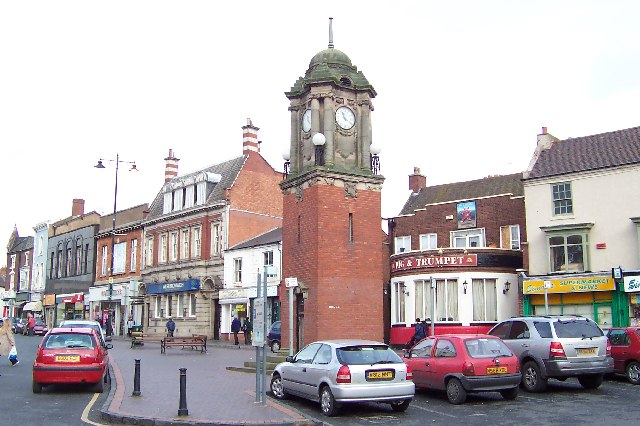


Wednesbury, United Kingdom
Wednesbury is a town of 20,313 people in England, United Kingdom.
Why visit Wednesbury
Townapedia lists 39 museums and landmarks, 35 parks and trails, 127 places to eat, 1 place to stay and 3 attractions in and around town.
Highlights include Bilston Town Hall, The Public, Bromwich Hall and Bilston Craft Gallery.
Weather in Wednesbury
Forecast from MET Norway (CC BY 4.0). Full forecast
About Wednesbury
Wednesbury ( locally [ˈwɛnzbriː]) is a market town in the Sandwell district, in the county of the West Midlands, England; it was historically in Staffordshire. It is located near the source of the River Tame and is part of the Black Country. Wednesbury is situated five miles (eight kilometres) southeast of Wolverhampton, three miles (five kilometres) southwest of Walsall and seven miles (eleven kilometres) northwest of Birmingham. At the 2021 Census, the town's built-up area had a population of 20,313.
From the Wikipedia article Wednesbury (this version), under CC BY-SA 4.0.
Things to do3

Bilston Town Hall
Cinema and theater · 2.4 mi
Theatre, events venue and former council house and cinema in Bilston, England

The Public
Cinema and theater · 2.6 mi
Former arts centre in West Bromwich, West Midlands, England

Museums and landmarks39

Bromwich Hall
Monument and historic site · 1.3 mi
Hall Green Road, West Bromwich

Bilston Craft Gallery
Museum · 2.3 mi
Museum and library in Bilston, Wolverhampton
Bishop Asbury Cottage
Museum · 2.9 mi
Cottage in Sandwell, West Midlands, England, UK

Black Country Living Museum
Museum · 3.0 mi
Open-air museum of manufacturing history in Dudley, West Midlands, England, United Kingdom

Oak House
Museum · 2.6 mi
Historic house museum in Greets Green, West Bromwich, England, UK

Sandwell Priory
Monument and historic site · 3.3 mi
Medieval Benedictine monastery, near West Bromwich, England

The New Art Gallery Walsall
Museum · 2.8 mi
Modern and contemporary art gallery in Walsall, England, United Kingdom

Walsall Leather Museum
Museum · 3.1 mi
Municipal museum in Walsall, England, United Kingdom


Locksmith's House
Museum · 2.7 mi
Museum in Willenhall, Staffordshire, England, United Kingdom

Walsall Castle
Monument and historic site · 2.5 mi
Manor house in Walsall, West Midlands, England
27 more on the map.
Parks, trails and playgrounds35
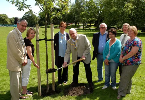
Brunswick Park
Park · 0.7 mi
Public park in Wednesbury, West Midlands, England, UK


Forge Mill Lake
Park · 3.2 mi
Lake and nature reserve in West Midlands, England, UK

Sandwell Valley RSPB reserve
Park · 3.3 mi
RSPB nature reserve in the English West Midlands county

Sheepwash Urban Park
Park · 2.1 mi
Local Nature Reserve in the West Midlands, England

Sot's Hole Local Nature Reserve
Park · 2.3 mi
Nature reserve in West Bromwich, UK

Victoria Park
Park · 2.4 mi
Public park in Tipton, Sandwell, West Midlands, England, UK

Peascroft Wood
Park · 2.5 mi
Nature reserve in the West Midlands, England
Sandwell Valley Country Park
Park · 2.8 mi
Country park in the English midlands
23 more on the map.
Restaurants and cafes127

Asda Café
Cafe · Coffee Shop · 1.5 mi
Brickhouse Lane South, West Bromwich
Mo 08:00-24:00; Tu-Fr 00:00-24:00; Sa 00:00-22:00; Su 10:00-16:00


Casa Mia
Restaurant · Mediterranean, Italian · 1.0 mi
74 Wood Green Road, Wednesbury
Mo-Su 17:00-23:00
Ghurka 1816
Restaurant · Indian, Asian, Nepalese · 1.0 mi
77 Wood Green Road, Wednesbury
Mo-Su 17:00-23:00

115 more on the map.
History
The substantial remains of a large ditch excavated in St Mary's Road in 2008, following the contours of the hill and predating the Early Medieval period, has been interpreted as part of a hilltop enclosure and possibly the Iron Age hillfort long suspected on the site. The first authenticated spelling of the name was Wodensbyri, written in an endorsement on the back of the copy of the will of Wulfric Spot, dated 1004. Wednesbury ("Woden's borough") is one of a number of places in England to be named after the pre-Christian deity Woden, the leader of the Old English pantheon.
During the Anglo-Saxon period there are believed to have been two battles fought in Wednesbury, in 592 and 715. According to The Anglo-Saxon Chronicle there was "a great slaughter" in 592 and "Ceawlin was driven out". Ceawlin was a king of Wessex and the second Bretwalda, or overlord of all Britain. The 715 battle was between Mercia (of which Wednesbury was part) and the kingdom of Wessex. Both sides allegedly claimed to have won the battle, although it is believed that the victory inclined to Wessex.
Read more of the history
Wednesbury was fortified by Æthelflæd (Ethelfleda), daughter of Alfred the Great and known as the Lady of Mercia. She erected five fortifications to defend against the Danes at Bridgnorth, Tamworth, Stafford and Warwick, with Wednesbury in the centre. Wednesbury's fort would probably have been an extension of an older fortification and made of a stone foundation with a wooden stockade above. Earthwork ramparts and water filled ditches would probably have added to its strength. A plaque on the gardens between Ethelfleda Terrace and St Bartholomew's church states that the gardens there – created in the 1950s – used stone from the graff, or fighting platform, of the old fort. Exploration of the gardens reveals several dressed stones, which appear to be those referred to on the plaque.
In 1086, the Domesday Book describes Wednesbury (Wadnesberie) as being a thriving rural community encompassing Bloxwich and Shelfield (now part of Walsall). During the Middle Ages the town was a rural village, with each family farming a strip of land with nearby heath being used for grazing. The town was held by the king until the reign of Henry II, when it passed to the Heronville family.
Medieval Wednesbury was very small, and its inhabitants would appear to have been farmers and farm workers. In 1315, coal pits were first recorded, which led to an increase in the number of jobs. Nail making was also in progress during these times. William Paget was born in Wednesbury in 1505, the son of a nail maker. He became Secretary of State, a Knight of the Garter and an Ambassador. He was one of executors of the will of Henry VIII.
In the 17th century Wednesbury pottery – "Wedgbury ware" – was being sold as far away as Worcester, while white clay from Monway Field was used to make tobacco pipes.
By the 18th century the main occupations were coal mining and nail making. With the introduction of the first turnpike road in 1727 and the development of canals and later the railways came a big increase in population. In 1769 the first Birmingham Canal was cut to link Wednesbury's coalfields to the Birmingham industries. The canal banks were soon full of factories.
In 1743, the Wesleys and their new Methodist movement were severely tested. Early in the year, John and Charles Wesley preached in the open air on the Tump. They were warmly received and made welcome by the vicar. Soon afterwards another preacher came and was rude about the current state of the Anglican clergy. This angered the vicar, and the magistrates published a notice ordering that any further preachers were to be brought to them. When Wesley next came his supporters were still there but a crowd of others heckled him and threw stones. Later the crowd came to his lodgings and took him to the magistrates, but they declined to have anything to do with Wesley or the crowd. The crowd ill-treated Wesley and nearly killed him but he remained calm. Eventually they came to their senses and returned him to his hosts.
Soon afterward, the vicar asked his congregation to pledge not to associate with Methodists, and some who refused to pledge had their windows smashed. Others who hosted Methodist meetings had the contents of their houses destroyed. This terrible episode came to an end in December when the vicar died. After that mainstream Anglican and Methodist relations were generally cordial. Methodism grew strongly and Wesley visited often, almost until his death. Francis Asbury, Richard Whatcoat and the Earl of Dartmouth are among those who attended Methodist meetings, all to have a profound effect on the United States.
In 1887, Brunswick Park was opened to celebrate Queen Victoria's Golden Jubilee.
On the evening of 31 January 1916, Wednesbury was hit by one of the first wave of German Zeppelins aimed at Britain during the First World War. Joseph Smith and his three children were killed in their house in the King Street area. His wife survived, having left the house to investigate the cause of a loud noise at a nearby factory, caused by the first bombs falling.
The first council houses in Wednesbury were built in the early 1920s, but progress was slow compared to nearby towns including Tipton and West Bromwich. By 1930, a mere 206 families had been rehoused from slums. However, the building of council houses quickened at the start of the 1930s; the 1,000th council house was occupied before the end of 1931. By 1935, some 1,250 older houses had been demolished or earmarked for demolition. By 1944 there were more than 3,000 council properties; by 1959, more than 5,000. The largest development in Wednesbury was the Hateley Heath estate in the late 1940s and early 1950s, which straddled the border of Wednesbury and West Bromwich.
From the History section of Wednesbury on Wikipedia, under CC BY-SA 4.0.
Notable people from Wednesbury
 Joanne Shaw TaylorBritish blues guitarist and singerPhoto: Original: Sven Mandel / Derivative..., CC BY-SA 4.0
 Alan HintonEnglish footballer and manager (born 1942)Photo: Noelle Noble, CC BY 2.0
 William Paget, 1st Baron PagetEnglish statesman (1506-1563)Photo: Master of the Stätthalterin Madonna..., Public domain
 Simon BrownBritish footballer (born 1983)Photo: https://www.flickr.com/photos/jamesboyes/, CC BY 2.0
 David HowarthBritish politician (born 1958)Photo: Laurence Boyce at English Wikipedia, CC BY-SA 3.0
 Roy ProverbsEnglish footballer (1932-2017)Photo: ProverbsPJ, CC BY-SA 4.0
 Marty HoganAmerican baseball player (1869-1923)Photo: Cal Keck Studio, Youngstown, OH, Public domain
- Garry CookBritish athlete
- Billy WalkerEnglish footballer and manager (1897-1964)
- Norman DeeleyEnglish footballer (1933-2007)
- John SlimOlympic wrestler (1885–1966)
- Kathleen GarmanBritish model
Born in Wednesbury, according to Wikidata (CC0). Each name links to its Wikipedia article.
Where to stay1
Churches and places of worship45
Church of All Saints
Church · Anglican · 1.2 mi
Walsall Road, Walsall
Shopping26
Gas and EV charging6
Schools, colleges and libraries39
Healthcare11
Great Bridge Kidney Treatment Centre
Clinic and pharmacy · 1.3 mi
Link One Industrial Park
Map of Wednesbury
250 places. The map loads OpenStreetMap tiles when you open it.
Getting there and nearby towns
Birmingham Airport (BHX) is the nearest airport with scheduled flights listed in OpenStreetMap, 14 miles away.
- West Bromwich 3 mi southeast, about 4 min by car
- Walsall 3 mi northeast, about 5 min by car
- Dudley 4 mi southwest, about 7 min by car
- Wolverhampton 5 mi northwest, about 8 min by car
- Birmingham 7 mi southeast, about 11 min by car
- Wombourne 7 mi west, about 11 min by car
- Sutton Coldfield 9 mi east, about 14 min by car
- Solihull 14 mi southeast, about 22 min by car
- Telford 20 mi northwest, about 32 min by car
- Coventry 24 mi southeast, about 38 min by car
Drive times are estimates from straight-line distance, not routes.
Towns near Wednesbury


Keep exploring
Local news
Headlines from INDB.
Reviews, tips and questions
Loading what members have shared...
Sources and licences
- GeoNames (CC BY 4.0): population, coordinates, regions and time zone
- Mapillary (see each image): photos
- OpenStreetMap contributors (ODbL 1.0): places, airports, map data
- Openverse (see each image): photos
- Wikidata (CC0 1.0): elevation, founding date, time zone, website, landmarks and historic places
- Wikimedia Commons (see each image): photos
- Wikipedia (CC BY-SA 4.0): overview and history text
Photo credits
- Wednesbury - the High Street, Adrian Bailey, CC BY-SA 2.0
- Bilston Town Hall, Brianboru100, CC BY-SA 3.0
- The Public north, David Waterson ( DWaterson ), CC BY-SA 3.0
- Blackcountrystreet, Jack1956, Public domain
- Oak House rear (3215480435), Tony Hisgett from Birmingham, UK, CC BY 2.0
- Sandwell - south chapels 02, Sjwells53, CC BY-SA 3.0
- Walsall Leather Museum, Brianboru100, CC BY-SA 3.0
- Dartmouth Park, West Bromwich - War Memorial (36184932921), Elliott Brown from Birmingham, United Kingdom, CC BY-SA 2.0
- Forge Mill Lake, Frombowen, CC BY-SA 4.0
- RSPB Reserve Gates 1, Tony Hisgett, CC BY 2.0
- Sheepwash Urban Park island, Sjwells53 at English Wikipedia, CC BY-SA 3.0
- Victoria Park, Tipton 070110 044 (4294752265), Sandwell Council, CC BY-SA 2.0
- Church Of St Martin And St Paul 1 West face, RexxS, CC BY-SA 4.0
- St Bartholomew's Wednesbury, Brianboru100, CC BY-SA 3.0
- Manor House 1 (3308438221), Tony Hisgett from Birmingham, UK, CC BY 2.0
- High School (27172108451), Peter Conway, CC BY 2.0
- St Lawrence Church, KelliW592, CC BY-SA 4.0
- Gate (3269748340), Tony Hisgett from Birmingham, UK, CC BY 2.0
- Bilston Craft Gallery and Library - Mount Pleasant, Bilston (27903837899), Elliott Brown from Birmingham, United Kingdom, CC BY-SA 2.0
- New Art Gallery Walsall - interior 11 - barrier tape, Andy Mabbett, CC BY-SA 3.0
- Wednesbury Museum and Art Gallery - Holyhead Road, Wednesbury (38535690832), Elliott Brown from Birmingham, United Kingdom, CC BY-SA 2.0
- Brunswick Park 01, MayorofSandwell, CC BY 2.0
- Street-level photo, adam2, CC BY-SA 4.0
- Street-level photo, mappo2, CC BY-SA 4.0
- Street-level photo, adam2, CC BY-SA 4.0
- Street-level photo, southglos, CC BY-SA 4.0


Page built November 10, 2026. Spotted a mistake? Tell us or suggest a place.