
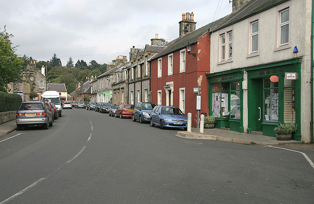


West Linton, United Kingdom
West Linton is a town of 1,530 people in Scotland, United Kingdom.
Why visit West Linton
Townapedia lists 6 museums and landmarks, 1 park or trail, 1 place to eat, 2 places to stay and 1 attraction in and around town.
Weather in West Linton
Forecast from MET Norway (CC BY 4.0). Full forecast
About West Linton
West Linton (Scottish Gaelic: Baile Linne Ruairidh) is a village and civil parish in southern Scotland, on the A702. It is situated within the historic county of Peeblesshire and the Scottish Borders council area. Many of its residents are commuters, owing to the village's proximity to Edinburgh, which is 16 miles (26 km) to the north-east. West Linton has a long history, and holds an annual traditional festival called the Whipman Play.
From the Wikipedia article West Linton (this version), under CC BY-SA 4.0.
Photos of West Linton


Things to do1

Museums and landmarks6

Parks, trails and playgrounds1

Restaurants and cafes1
History
The village is of ancient origin. It was historically named Linton Roderick, Linton Rutherick and Linton, the latter meaning "town on the lin or pool", presumably referring to its location on the Lyne Water. At some point, the village was renamed to West Linton in order to distinguish it from East Linton in East Lothian.
West Linton's development was influenced by its position along historic routes through Tweeddale and the Pentland Hills, linking the upper Clyde Valley with the River Forth basin.
During the medieval period, the surrounding area formed part of estates associated with local landowning families, and the economy was primarily agricultural. Archaeological evidence indicates that lead mining was an important activity from at least the 12th century, particularly in the surrounding upland areas such as Siller Holes, where mining continued into the later medieval period.
By the early modern period, West Linton had developed into a small rural settlement serving nearby farms and mining communities. Significant growth occurred during the 18th and 19th centuries, when improvements in road infrastructure and the introduction of turnpike routes enhanced trade and movement through the area. Weaving, quarrying and mining provided employment, while the construction of the nearby Broomlee railway station strengthened connections with Edinburgh and the wider Borders region.
Read more of the history
Although the railway line closed in 1933, West Linton continued to evolve throughout the 20th century, with the decline of local industries accompanied by a gradual transition toward residential development and increased commuting to Edinburgh.
From the History section of West Linton on Wikipedia, under CC BY-SA 4.0.
More about West Linton
Arts and culture
The village is home to the football club Linton Hotspur, based at New Moor Road after its 2008 re-establishment. In 2023, the club was admitted to the Third Division of the East of Scotland Football League, and was promoted to the Second Division in the 2024-25 season with a second-place finish.
The Whipman Play is an annual summer festival held in the village, and is one of the Borders' oldest festivals the Whipman being the local man chosen as the focus of festivities. The festival commences on the Friday before the first Saturday in June, and runs until the following Saturday. The Whipman Play Society was formed in 1803 by local young men to alleviate hardship and illness for its members and in the community at large, 42 years before the Poor Law Amendment (Scotland) Act, 1845, and possibly before the first insurance company in Scotland.
Each year a local man is elected to the office of Whipman and he chooses the Whipman's Lass to assist him. These two represent the village at other Lothian and Borders festivals throughout their year in office. The celebrations begin with the Installation of the Whipman & Lass, followed by a celebratory ceilidh. The following day, the Ride Out (of around 80 to 100 horses) introduces the Whipman to the area, and a full week of events culminates in the annual sports day, held on the village green.
From the Wikipedia article West Linton, under CC BY-SA 4.0.
Notable people from West Linton
 Thomas BrydoneNew Zealand land company manager, farm manager and freezing industry developer (1837-1904)Photo: Unknown author Unknown author, Public domain
- John Brown ClarkBorn: 30 April 1861 in West Linton, Peebleshire, Scotland; Died: 19 July 1947 in Edinburgh, Scotland
- Una CameronBritish mountain climber (1904–1987)
Born in West Linton, according to Wikidata (CC0). Each name links to its Wikipedia article.
Where to stay2
Churches and places of worship2
Schools, colleges and libraries2
Healthcare1
Map of West Linton
16 places. The map loads OpenStreetMap tiles when you open it.
Getting there and nearby towns
Edinburgh Airport (EDI) is the nearest airport with scheduled flights listed in OpenStreetMap, 14 miles away.
- Penicuik 8 mi northeast, about 12 min by car
- Livingston 12 mi northwest, about 20 min by car
- Bonnyrigg 13 mi northeast, about 21 min by car
- Broxburn 14 mi north, about 22 min by car
- Edinburgh 15 mi northeast, about 25 min by car
- Bathgate 15 mi northwest, about 25 min by car
- Mayfield 15 mi northeast, about 24 min by car
- Dalkeith 15 mi northeast, about 24 min by car
- Whitburn 15 mi northwest, about 24 min by car
- Armadale 16 mi northwest, about 26 min by car
Drive times are estimates from straight-line distance, not routes.
Towns near West Linton


Keep exploring
Local news
Headlines from INDB.
Reviews, tips and questions
Loading what members have shared...
Sources and licences
- GeoNames (CC BY 4.0): population, coordinates, regions and time zone
- Mapillary (see each image): photos
- OpenStreetMap contributors (ODbL 1.0): places, airports, map data
- Wikidata (CC0 1.0): elevation, founding date, time zone, website
- Wikimedia Commons (see each image): photos
- Wikipedia (CC BY-SA 4.0): overview and history text
Photo credits
- Liontan Ruairidh 990607, Walter Baxter, CC BY-SA 2.0
- West Linton Church, Jonathan Oldenbuck, CC BY-SA 3.0
- 07390 West Linton Church of Scotland & BG, West Linton 026, WeeHolly, CC BY-SA 4.0
- 07390 West Linton Church of Scotland & BG, West Linton 047, WeeHolly, CC BY-SA 4.0
- 07390 West Linton Church of Scotland & BG, West Linton 022, WeeHolly, CC BY-SA 4.0
- 07390 West Linton Church of Scotland & BG, West Linton 029, WeeHolly, CC BY-SA 4.0
- 07390 West Linton Church of Scotland & BG, West Linton 020, WeeHolly, CC BY-SA 4.0
- 07390 West Linton Church of Scotland & BG, West Linton 001, WeeHolly, CC BY-SA 4.0
- 07390 West Linton Church of Scotland & BG, West Linton 046, WeeHolly, CC BY-SA 4.0
- 07390 West Linton Church of Scotland & BG, West Linton 028, WeeHolly, CC BY-SA 4.0
- St Andrews Church and Old Toll House West Linton Peeblesshire, HWood, CC BY-SA 4.0
- Street-level photo, ccbb7766, CC BY-SA 4.0
- Street-level photo, drnoble, CC BY-SA 4.0


Page built November 10, 2026. Spotted a mistake? Tell us or suggest a place.