
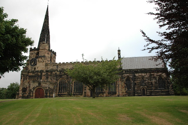


Why visit Winwick
Townapedia lists 10 museums and landmarks, 14 parks and trails, 15 places to eat, 2 places to stay and 4 attractions in and around town.
Highlights include Warrington Bridge, Gulliver's World Resort, Warrington Museum and Art Gallery and Battle of Winwick.
Weather in Winwick
Forecast from MET Norway (CC BY 4.0). Full forecast
About Winwick
Winwick is a village and civil parish in the Borough of Warrington, Cheshire, England. Located within the historic boundaries of Lancashire, it is situated about 3 miles (4.8 km) north of Warrington town centre, nearby is junction 22 of the M6 motorway and junction 9 of the M62. Winwick borders Newton-le-Willows and Burtonwood. At the 2021 census, the village had a population of 2,060, while the wider civil parish had a population of 4,899.
From the Wikipedia article Winwick, Cheshire (this version), under CC BY-SA 4.0.
Things to do4

Warrington Bridge
Bridge · 3.3 mi
Bridge in Warrington, Cheshire, England, United Kingdom

Gulliver's World Resort
Monument and historic site · 2.0 mi
Children's theme park resort in Warrington, Cheshire.

Howley Footbridge
Bridge · 3.3 mi
Footbridge in Warrington, Cheshire, England, UK

Museums and landmarks10

Warrington Museum and Art Gallery
Museum · 3.2 mi
Grade II listed building and museum in Warrington, United Kingdom


Museum of Policing in Cheshire
Museum · 3.3 mi
Museum in Warrington, England, United Kingdom
Parks, trails and playgrounds14
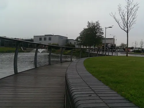

Culcheth Linear Park
Park · 3.1 mi
Park in the district of Culcheth, Warrington, England

Highfield Moss
Park · 1.6 mi
Nature reserve in Greater Manchester, England


Orford Park
Park · 2.1 mi
Park in Orford, Warrington, Cheshire, England, United Kingdom
Paddington Meadows
Park · 3.3 mi
Nature reserve in Paddington, Warrington, Cheshire, England, United Kingdom
Woolston Park
Park · 3.1 mi
Park in Woolston, Warrington, Cheshire, England, United Kingdom



2 more on the map.
Restaurants and cafes15




3 more on the map.
History
King Oswald of Northumbria is believed to have been killed in the Winwick area and the parish church, dedicated to him, was reputedly located with guidance from the "Winwick Pig", a carving of which can still be seen on the church wall. Richard Sherlock was the incumbent at Winwick for some thirty years in the seventeenth century, and Thomas Wilson, Bishop of Sodor and Man, spent his early years in the care of Sherlock at Winwick.
At the time of the Domesday Survey (1086), the village itself was also known as St Oswalds. This was little more than four hundred years after the death of Oswald. In the church, the remains of a 7th-century stone cross with an engraving of the reputed demise of Oswald can be seen.
Winwick was the site of the battle of Winwick in the second English Civil War on 19 August 1648, where Oliver Cromwell defeated a mainly Scottish Royalist army.
The captain of the RMS Titanic, Edward Smith, married Sarah Eleanor Pennington on 13 January 1887 at St Oswald's Church.
In the 1934 Winwick rail crash 11 people were killed and 19 people were injured. Another accident occurred in 1967, but there were no fatalities or serious injuries.
From the History section of Winwick, Cheshire on Wikipedia, under CC BY-SA 4.0.
Notable people from Winwick
 Geoffrey HornbyBritish admiral; (1825-1895)Photo: Russell (photographic company ), Public domain
- Phipps HornbyBritish Royal Navy officer (1785-1867)
- James John HornbyBritish Provost of Eton and rower (1826-1909)
- Thomas ClaughtonAnglican bishop (1808-1892)
- Thomas HazlehurstSoap and alkali manufacturer
Born in Winwick, according to Wikidata (CC0). Each name links to its Wikipedia article.
Where to stay2
Churches and places of worship18
Emmanuel Wargrave Church
Church · Anglican · 1.4 mi
Church Drive, Newton-le-Willows
Saint David's Catholic Church
Church · Roman Catholic · 1.5 mi
311 Wargrave Road, Newton-le-Willows
Shopping4
Gas and EV charging2
Schools, colleges and libraries8
Healthcare4
Map of Winwick
81 places. The map loads OpenStreetMap tiles when you open it.
Getting there and nearby towns
Liverpool John Lennon Airport (LPL) is the nearest airport with scheduled flights listed in OpenStreetMap, 12 miles away.
- Newton-le-Willows 1 mi north, about 2 min by car
- Croft 2 mi east, about 3 min by car
- Warrington 3 mi south, about 5 min by car
- Golborne 3 mi north, about 5 min by car
- Great Sankey 3 mi southwest, about 5 min by car
- Ashton in Makerfield 4 mi northwest, about 6 min by car
- Haydock 4 mi northwest, about 7 min by car
- Leigh 5 mi northeast, about 9 min by car
- Abram 5 mi north, about 8 min by car
- St Helens 6 mi west, about 9 min by car
Drive times are estimates from straight-line distance, not routes.
Towns near Winwick


Keep exploring
Local news
Headlines from INDB.
Reviews, tips and questions
Loading what members have shared...
Sources and licences
- GeoNames (CC BY 4.0): population, coordinates, regions and time zone
- Mapillary (see each image): photos
- OpenStreetMap contributors (ODbL 1.0): places, airports, map data
- Wikidata (CC0 1.0): elevation, founding date, time zone, website, landmarks and historic places
- Wikimedia Commons (see each image): photos
- Wikipedia (CC BY-SA 4.0): overview and history text
Photo credits
- St Oswald's Church, Winwick, andy, CC BY-SA 2.0
- The Winwick Pig on the clock tower of Winwick Church, Cheshire, Benjamin Shaw, CC BY-SA 4.0
- Temporary grave markers, Winwick Churchyard, Benjamin Shaw, CC BY-SA 4.0
- Mersey Street Bridge, Warrington, Lancs, Mersey_Street_Bridge,_Warrington_-_DSC05919.JPG : Green Lane derivative work: Hogweard ( talk ), CC BY-SA 3.0
- Front of Museum, RDJ226, CC BY 3.0
- Sankey Valley Park May 2007, Daniel Bagshaw ( Dan1980 ), CC BY 3.0
- Church of St James the Great, Haydock 1, Rodhullandemu, CC BY-SA 4.0
- St John the Baptist Church, Earlestown 1, Rodhullandemu, CC BY-SA 4.0
- Emmanuel Wargrave Church 5, Rodhullandemu, CC BY-SA 4.0
- St David's Church, Newton-le-Willows 1, Rodhullandemu, CC BY-SA 4.0
- Culcheth Linear Park Entrance, OpenStreetMap contributors https://www.openstreetmap.org/copyright, CC BY 4.0
- Galatea At Highfield Moss, ARG_Flickr, CC BY 2.0
- Street-level photo, trigpoint, CC BY-SA 4.0
- Street-level photo, ianatkin, CC BY-SA 4.0
- Street-level photo, mapillarygelec, CC BY-SA 4.0
- Street-level photo, trigpoint, CC BY-SA 4.0
- Street-level photo, mapillarygelec, CC BY-SA 4.0


Page built November 10, 2026. Spotted a mistake? Tell us or suggest a place.