


Wymeswold, United Kingdom
Wymeswold is a town of 1,296 people in England, United Kingdom.
Why visit Wymeswold
Townapedia lists 2 museums and landmarks, 3 parks and trails, 5 places to eat, 1 place to stay and 1 attraction in and around town.
Highlights include Stanford Hall and Wymeswold Meadows.
Weather in Wymeswold
Forecast from MET Norway (CC BY 4.0). Full forecast
About Wymeswold
Wymeswold () is a village and civil parish in the Charnwood district of Leicestershire, England. It is in the north of Leicestershire, and north-east of Loughborough. The village has a population of about 1,000, measured at 1,296 in the 2011 census. It is close to Prestwold and Burton on the Wolds in Leicestershire, and the Nottinghamshire villages of Rempstone and Willoughby on the Wolds.
From the Wikipedia article Wymeswold (this version), under CC BY-SA 4.0.
Things to do1

Stanford Hall
Cinema and theater · 2.5 mi
Country house in Nottinghamshire, England, UK
Museums and landmarks2

Parks, trails and playgrounds3



Restaurants and cafes5

Greyhound Inn
Bar and pub · 1.5 mi
25 Melton Road, Loughborough
Mo-Fr 12:00-15:00,17:00-23:00; Sa-Su 12:00-23:00
History
There used to be a school in the village run by Thomas Potter in the nineteenth century on Elm Street. The school was moved to a site to the south of the village when it expanded in the 1970s. The village was formerly the site of RAF Wymeswold, a memorial to which can be seen on the wall of Wymeswold pharmacy remembers when a Wellington bomber on a night training exercise crashed up on a hill nearby, just two miles from the airfield, on 25 November 1943. Six crew members died at the scene and a seventh died of his injuries three days later; the trainee rear gunner was the sole survivor. The Wymeswold airstrip still remains, although disused, is now used as a track for performance car 'experience' days, although there is some local opposition to this because of the noise. The former airfield is also the home for Airbossworld Kitepark. In 1939 a YHA youth Hostel opened in Wymeswold and subsequently shut in 1946.
The village has a history of cheese making, particularly Stilton, with six dairies making it in the 1920s. More recently, it was planned to make the newly- invented Lymeswold cheese at Wymeswold Dairy in the 1980s, but in the event production switched to Somerset.
Read more of the history
The village has a greengrocer and general store, specialised pine furniture and gift shop, two pubs (The Three Crowns and The Windmill) and a restaurant (Hammer and Pincers). The Three Crowns was CAMRA Loughborough and North Leicestershire 2010 Village Pub of the Year. The village holds two fund raising events in the summer— the Wymeswold Duck Race (mid May) and the Wymeswold Open Gardens (mid June). Wymeswold Running Club organises the 'Waddle', a 5-mile road race on closed roads, to take place on the same day as the Duck Race. The post office was closed in May 2008, as part of the Royal Mail's restructuring. An outreach service has been opened in The Three Crowns. At the southern edge of the village, the 'Washdyke' recreational area includes a community orchard.
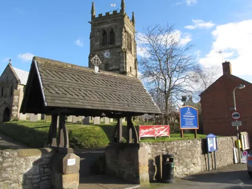
St Mary's church was restored in 1844 by A. W. N. Pugin. It contains the Leeke memorial to Judge William Leeke who was Lord of the Manor of Wymeswold in the mid-17th century. His widow presented the church with a silver flagon and paten that are now in the Charnwood museum. The remarkable windows were the work of John Hardman Studios, Birmingham. The churchyard contains one a noted collection of Swithland slate headstones . The village was a centre of Swithland slate carving and home to the fine slate craftsmen, William Charles, the Winfields and Roworth.
Henry Alford was the Vicar of Wymeswold from 1835 to 1853 and wrote many of his hymns here.
From the History section of Wymeswold on Wikipedia, under CC BY-SA 4.0.
Notable people from Wymeswold
- Ivor BrownEnglish speedway rider
Born in Wymeswold, according to Wikidata (CC0). Each name links to its Wikipedia article.
Where to stay1
Churches and places of worship9
Church of St Mary and All Saints, Willoughby-on-the-Wolds
Church · 2.5 mi
Schools, colleges and libraries1
Healthcare1
Map of Wymeswold
23 places. The map loads OpenStreetMap tiles when you open it.
Getting there and nearby towns
Nottingham City Airport (NQT) is the nearest airport with scheduled flights listed in OpenStreetMap, 8 miles away.
- Loughborough 5 mi southwest, about 7 min by car
- Mountsorrel 6 mi south, about 10 min by car
- Shepshed 8 mi west, about 13 min by car
- Long Clawson 8 mi east, about 13 min by car
- West Bridgford 9 mi north, about 14 min by car
- Long Eaton 9 mi northwest, about 15 min by car
- Syston 9 mi south, about 14 min by car
- Chilwell 9 mi northwest, about 14 min by car
- Nottingham 10 mi north, about 17 min by car
- Melton Mowbray 10 mi east, about 16 min by car
Drive times are estimates from straight-line distance, not routes.
Towns near Wymeswold


Keep exploring
Local news
Headlines from INDB.
Reviews, tips and questions
Loading what members have shared...
Sources and licences
- GeoNames (CC BY 4.0): population, coordinates, regions and time zone
- Mapillary (see each image): photos
- OpenStreetMap contributors (ODbL 1.0): places, airports, map data
- Wikidata (CC0 1.0): elevation, founding date, time zone, website, landmarks and historic places
- Wikimedia Commons (see each image): photos
- Wikipedia (CC BY-SA 4.0): overview and history text
Photo credits
- Stanford Hall Notts, John Beniston, CC BY 3.0
- Wymeswold Meadows 4, Dudley Miles, CC BY-SA 4.0
- Holy Trinity Church Wysall Nottinghamshire, Russ Hamer, CC BY-SA 3.0
- St. Mary's Church, Wymeswold 07, Simon Burchell, CC BY-SA 4.0
- Street-level photo, southglos, CC BY-SA 4.0
- Street-level photo, sk53, CC BY-SA 4.0
- Street-level photo, southglos, CC BY-SA 4.0
- Street-level photo, sk53, CC BY-SA 4.0
- Street-level photo, southglos, CC BY-SA 4.0
- Street-level photo, southglos, CC BY-SA 4.0
Page built November 10, 2026. Spotted a mistake? Tell us or suggest a place.