
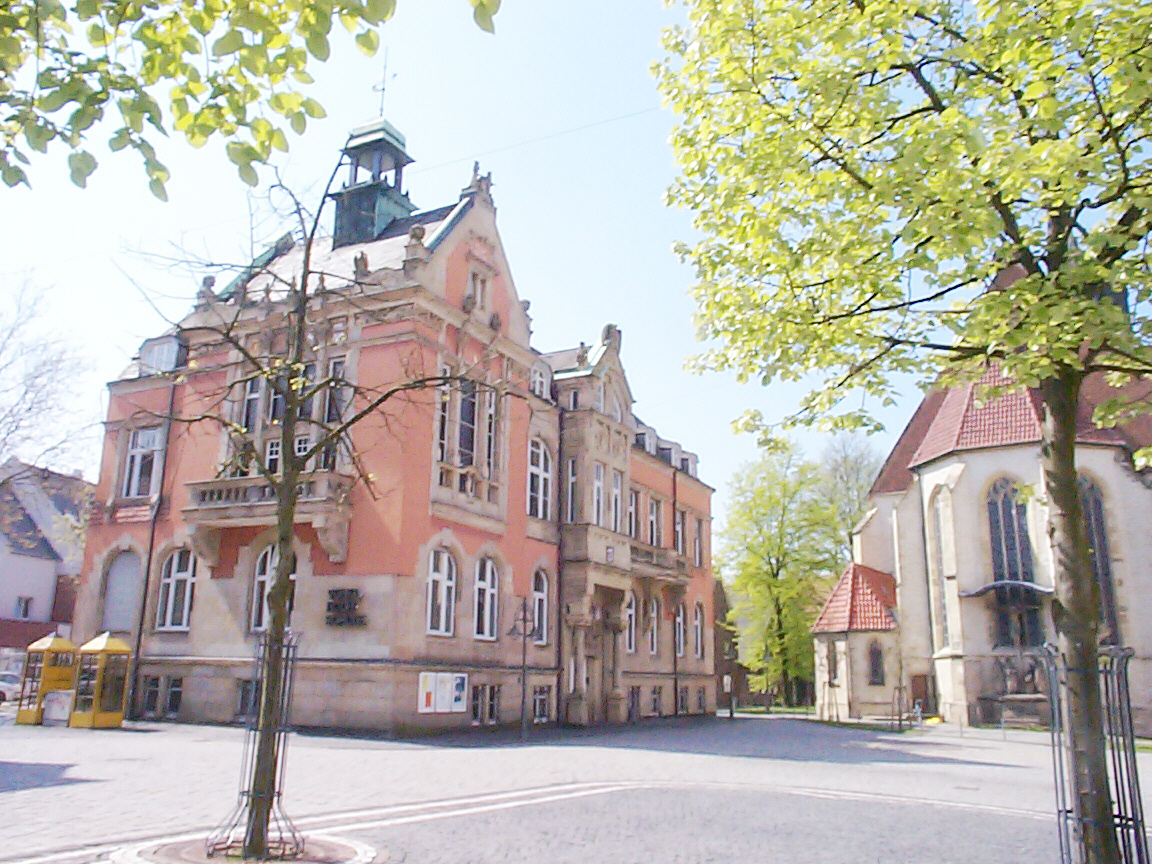


Why visit Ahlen
Townapedia lists 256 museums and landmarks, 46 parks and trails, 98 places to eat, 8 places to stay and 12 attractions in and around town.
Highlights include Waldbühne Heessen, CinemAhlen, Kunstmuseum Ahlen and Heimatmuseum.
Weather in Ahlen
Forecast from MET Norway (CC BY 4.0). Full forecast
About Ahlen
Ahlen (German pronunciation: [ˈaːlən] ; Westphalian: Aulen) is a town in North Rhine-Westphalia, Germany, 30 km southeast of Münster. Ahlen is part of the District of Warendorf and is economically the most important town in that district. Ahlen is part of the larger Münster region, and of the historic Münsterland area.
From the Wikipedia article Ahlen (this version), under CC BY-SA 4.0.
Photos of Ahlen


Things to do12






Museums and landmarks256


Haus Vorhelm
Monument and historic site · 6.6 km
10-14 Droste-zu-Vischering-Weg, Ahlen



244 more on the map.
Parks, trails and playgrounds46




34 more on the map.
Restaurants and cafes98
China Palast Ahlen
Restaurant · Asian · 3.5 km
341 Hammer Straße, Ahlen
Mo-Sa 17:00-23:30; We-Sa 11:30-15:00; Su,PH 11:30-23:30
Holzofenbäckerei Zimmermeier
Bakery · Regional · 0.7 km
30 Kapellenstraße, Ahlen
Mo-Sa 05:30-18:00, Su 08:00-18:00
Bäckerei Lippling
Bakery · 6.5 km
7 Heessener Straße, Ahlen
Mo-Fr 06:00-12:30,14:30-18:00; Sa 06:00-12:30; Su 07:30-10:30; PH off

Schulze Rötering
Cafe · Regional · 4.8 km
115 Prozessionsweg, Ahlen
We-Fr 14:00-18:00; Sa 12:00-18:00; Su 09:00-18:00

ANSPRECHBAR
Restaurant · Pizza, Burger, Coffee Shop, Sandwich · 2.4 km
1 Zeche Westfalen, Ahlen
Mo-Th 08:30-13:30; Fr 08:30-13:00
Bürgerzentrum Schuhfabrik
Restaurant
7 Königstraße, Ahlen
Tu-Th 12:00-22:00; Fr,Sa 12:00-01:00; Mo,Su,PH off
86 more on the map.
History
The first recorded mention of Ahlen is in the Vita Liudgeri, dating to about the year 850. The reason for the name, which means "eels", are unknown. An eel bedecked with a crown and feathers is on the town's coat of arms.
The start of settlement was likely due to there being a crossing over the river Werse, which was also the crossing of two key roads (Hamm–Ahlen–Warendorf and Beckum–Ahlen–Herbern), and the beginning of a third road (Ahlen–Münster).
In its early centuries, the fledgling settlement was built around an episcopal court. Within the safe haven of this church fortification, the first settlers were craftsmen and merchants who traded with the local farmers and peasants of the court.
Long-distance trading started in the second half of the 12th century — proof being the names of Ahlen merchants found on invoices from merchants in Lübeck. Ahlen was also part of the north German Hanse. During this time a town wall with five towers was built (about 1271). The stripping away of the town wall had begun in the year 1765 and the last hint of it was gone by 1929.
Ahlen grew quickly during the 13th century and in or about the year 1285, the population was so high that a new church (St. Marien) was founded next to the old one (St. Bartholomäus). This leads to the likelihood that Ahlen was one of the 18 biggest towns in Westphalia, at that time.
Read more of the history
However, the town's growth was hindered in the 14th century by the Black Death. According to the town's census book of 1389, only 63 families were left in Ahlen. But the town rebounded. In 1454, a citizen list showed 212 families living in Ahlen; seven noble families and their attendants lived in the episcopal court as well. Based on this number of families, a calculated population estimate of 1,300 citizens would be realistic. By this time the town had four quarters — all of which being about the same size and each quarter being named after its own town gate.
Each quarter was responsible for defending its part of the town wall and gate.
During the 16th century, there were three plague epidemics in 1505, 1551 and 1592; leprosy also killed many people. In the year 1571, the mayor and the council decided to build a special hospital for leprosy. Disastrous fires in 1483, 1668 and 1744 were responsible for further halting Ahlen's growth.
About 20 documents of witch trials during the time from 1574 until 1652 survive. The hunt for witches started in 1574 with the death of four women. Thereafter, Peter Kleikamp was charged with being a werewolf; he was tortured and burned alive on the pyre. In 1616, Christian zum Loe was charged with wizardry; he went insane and died while in jail. The last known case was in 1652 against Anna Sadelers; she was tortured, burned alive on the pyre and beheaded.
In 1938 the people of Ahlen destroyed the Ahlen synagogue. By November 1938, there were no more Jews in Ahlen.
From the History section of Ahlen on Wikipedia, under CC BY-SA 4.0.
More about Ahlen
Geography
Surrounding Ahlen are the towns of Sendenhorst, Ennigerloh, Beckum, Lippetal, Heessen (District of the city of Hamm) and Drensteinfurt.
Ahlen (downtown) with the farming communities of Borbein, Brockhausen, Ester, Halene, Oestrich and Rosendahl (area of the former town sections of Alt- and Neuahlen) all make up the core of the town.
Economy
One of the best known companies in Ahlen is Franz Kaldewei GmbH & Co. KG, one of the biggest bathtub manufacturers worldwide. Also well known is LR Health & Beauty Systems, which was bought by Apax Partners in 2004.
Ahlen station is on the Hamm–Minden railway and is served every hour by the Rhein-Weser-Express and the Ems-Börde-Bahn.
Therese-Münsterteicher Gesamtschule (former Städtische Gesamtschule)
The Sekundarschule and TMG used the building of the former Realschule
Fachschulen für Heilerziehungspflege der Caritas-Trägergesellschaft Nord
Fachseminar für Altenpflege Gemeinnütziges Bildungszentrum GmbH
Krankenpflegeschule im St.-Franziskus-Hospital Berufskolleg Ahlen
From the Wikipedia article Ahlen, under CC BY-SA 4.0.
Notable people from Ahlen
 Christian SüßGerman table tennis playerPhoto: Original uploader was Andylx at pl.wikipedia, GFDL
 Alexander KlawsGerman singer and actorPhoto: Stefan Brending ( 2eight ), CC BY-SA 3.0 de
 Lamya KaddorGerman Muslim religious educator and authorPhoto: Superbass, CC BY-SA 4.0
 Manfred R. SchroederGerman acoustical engineer (1926-2009)Photo: GFHund, CC BY 3.0
 Wendelin WiedekingGerman businessmanPhoto: Rolf Kickuth, CC BY-SA 4.0
 Alicia LangerGerman handball playerPhoto: Max Petershans, CC BY-SA 4.0
 Samuel BambaGerman footballer (born 2000)Photo: Sandro Halank, Wikimedia Commons, CC BY-SA 4.0
 Friedrich Caspar von GeismarGerman military personnelPhoto: Гравюра Ивана Ивановича Матюшина, Public domain
- Curro TorresSpanish footballer and manager
- Daniel WestmattelmannGerman bicycle racer and researcher
- Heinrich von StadenGerman diplomat and author
- Katharina Sibylla SchückingGerman writer (1791–1831)
Born in Ahlen, according to Wikidata (CC0). Each name links to its Wikipedia article.
Where to stay8
Churches and places of worship31
Kirche Sankt Johannes der Täufer
Church · Orthodox · 1.8 km
34 Jägerstraße, Ahlen
Sankt Antonius
Church · Roman Catholic · 6.6 km
12 Tönnishäuschen, Ahlen
St.-Pankratius-Kirche
Church · Catholic · 6.4 km
22 Pankratiusstraße, Ahlen
Shopping73
Gas and EV charging14
Schools, colleges and libraries30
Fritz-Winter-Gesamtschule
School · 1.3 km
13 August-Kirchner-Straße, Ahlen
Healthcare17
Map of Ahlen
250 places. The map loads OpenStreetMap tiles when you open it.
Getting there and nearby towns
Dortmund Airport (DTM) is the nearest airport with scheduled flights listed in OpenStreetMap, 33 km away.
- Hamm 10 km southwest, about 10 min by car
- Sendenhorst 10 km northwest, about 10 min by car
- Beckum 10 km east, about 10 min by car
- Drensteinfurt 11 km west, about 11 min by car
- Ennigerloh 13 km northeast, about 13 min by car
- Welver 17 km south, about 17 min by car
- Everswinkel 18 km north, about 18 min by car
- Oelde 19 km east, about 19 min by car
- Ascheberg 19 km west, about 19 min by car
- Bönen 20 km southwest, about 20 min by car
Drive times are estimates from straight-line distance, not routes.
Towns near Ahlen


Keep exploring
Local news
Headlines from INDB.
Reviews, tips and questions
Loading what members have shared...
Sources and licences
- GeoNames (CC BY 4.0): population, coordinates, regions and time zone
- Mapillary (see each image): photos
- OpenStreetMap contributors (ODbL 1.0): places, airports, map data
- Wikidata (CC0 1.0): elevation, founding date, time zone, website, landmarks and historic places
- Wikimedia Commons (see each image): photos
- Wikipedia (CC BY-SA 4.0): overview and history text
Photo credits
- Old town hall ahlen, User:Daidalus, CC BY-SA 3.0
- Ahlen - Baustelle Marktplatz (2), Michael Schmalenstroer, CC BY-SA 4.0
- Ahlen - Fußgängerzone 3, Michael Schmalenstroer, CC BY-SA 4.0
- Ahlen - Fußgängerzone 2, Michael Schmalenstroer, CC BY-SA 4.0
- St. Marien Ahlen 01, H.Helmlechner, CC BY-SA 4.0
- Ahlen - Archäologisches Fenster auf dem Marktplatz, Michael Schmalenstroer, CC BY-SA 4.0
- Ahlen - Baustelle Marktplatz im April 2018 3, Michael Schmalenstroer, CC BY-SA 4.0
- Ahlen - Baustelle Marktplatz im April 2018 4, Michael Schmalenstroer, CC BY-SA 4.0
- Ahlen - Baustelle Marktplatz im April 2018 2, Michael Schmalenstroer, CC BY-SA 4.0
- Ahlen - Baustelle Marktplatz im April 2018 1, Michael Schmalenstroer, CC BY-SA 4.0
- Ahlen - Baustelle Marktplatz, Michael Schmalenstroer, CC BY-SA 4.0
- Kreuzigungsgruppe an St. Bartholomäus, Ahlen, Gerd Fahrenhorst, CC BY 4.0
- Innenstadt, Ahlen, Germany - panoramio (118), Foto Fitti, CC BY-SA 3.0
- Innenstadt, Ahlen, Germany - panoramio (128), Foto Fitti, CC BY-SA 3.0
- St. Marien Ahlen 04, H.Helmlechner, CC BY-SA 4.0
- Ahlen - Kirche, Michael Schmalenstroer, CC BY-SA 4.0
- St. Marien Ahlen 02, H.Helmlechner, CC BY-SA 4.0
- Innenstadt, Ahlen, Germany - panoramio (132), Foto Fitti, CC BY-SA 3.0
- Ahlen westfalen germany, Arne Müseler / www.arne-mueseler.com, CC BY-SA 3.0 de
- Ahlen - Gedenkstätte St. Ludgerus, Michael Schmalenstroer, CC BY-SA 4.0
- Ahlen - Baustelle Marktplatz im April 2018 5, Michael Schmalenstroer, CC BY-SA 4.0
- Innenstadt, Ahlen, Germany - panoramio (120), Foto Fitti, CC BY-SA 3.0
- Ahlen - Fußgängerzone 4, Michael Schmalenstroer, CC BY-SA 4.0
- St. Marien Ahlen 03, H.Helmlechner, CC BY-SA 4.0
- Ahlen - Fußgängerzone, Michael Schmalenstroer, CC BY-SA 4.0
- Ahlen - Glückauf Apotheke, Michael Schmalenstroer, CC BY-SA 4.0
- Innenstadt, Ahlen, Germany - panoramio (119), Foto Fitti, CC BY-SA 3.0
- Innenstadt, Ahlen, Germany - panoramio (129), Foto Fitti, CC BY-SA 3.0
- Innenstadt, Ahlen, Germany - panoramio (133), Foto Fitti, CC BY-SA 3.0
- Innenstadt, Ahlen, Germany - panoramio (122), Foto Fitti, CC BY-SA 3.0
- Innenstadt, Ahlen, Germany - panoramio (117), Foto Fitti, CC BY-SA 3.0
- Badeszene (Ahlen) 1, Gerd Fahrenhorst, CC BY 4.0
- Badeszene (Ahlen) 3, Gerd Fahrenhorst, CC BY 4.0
- Badeszene (Ahlen) 4, Gerd Fahrenhorst, CC BY 4.0
- Badeszene (Ahlen) 2, Gerd Fahrenhorst, CC BY 4.0
- Innenstadt, Ahlen, Germany - panoramio (131), Foto Fitti, CC BY-SA 3.0
- Innenstadt, Ahlen, Germany - panoramio (134), Foto Fitti, CC BY-SA 3.0
- Innenstadt, Ahlen, Germany - panoramio (125), Foto Fitti, CC BY-SA 3.0
- HSHL Luftbild Hamm 2015, Reckmann, CC BY-SA 4.0
- St. Lambertus Dolberg - Nordwestansicht.nnw, NordNordWest, CC BY-SA 3.0 de
- St. Marien Ahlen.nnw, NordNordWest, CC BY-SA 3.0 de
- Fritz-Winter-Gesamtschule Ahlen.Eingang.nnw, NordNordWest, CC BY-SA 3.0 de
- Haus Küchen.2.nnw, NordNordWest, CC BY-SA 3.0 de
- Luftbild Schloss Oberwerries, Tim Reckmann, CC BY-SA 3.0
- Kunstmuseum Ahlen.nnw, NordNordWest, CC BY-SA 3.0 de
- St. Antonius Tönnishäuschen.nnw, NordNordWest, CC BY-SA 3.0 de
- Stadtbücherei Ahlen.2.nnw, NordNordWest, CC BY-SA 3.0 de
- Stolpersteine Familie Moszkowicz Klosterstraße 13 Ahlen.2017.nnw, NordNordWest, CC BY-SA 3.0 de
- Stolpersteine Metzger-Spiegel Südstraße 28 Ahlen 2018.nnw, NordNordWest, CC BY-SA 3.0 de
- Stolpersteine Grosch-Loe-Simon-Spiegel Weststraße 73 Ahlen.nnw, NordNordWest, CC BY-SA 3.0 de
- St. Pankratius Vorhelm Südseite.nnw, NordNordWest, CC BY-SA 3.0 de
- Ahlen - Heimatmuseum, Michael Schmalenstroer, CC BY-SA 4.0
- St. Josef Ahlen 2, NordNordWest, CC BY-SA 3.0 de
- Haus Vorhelm 02, H.Helmlechner, CC BY-SA 4.0
- St. Barbara-Klinik - panoramio, Foto Fitti, CC BY-SA 3.0
- St. Michael Ahlen.nnw, NordNordWest, CC BY-SA 3.0 de
- St. Gottfried, Ahlen, Michael Sch., CC BY 3.0
- Fritz-Winter-Haus Ahlen Seitenansicht, NordNordWest, CC BY-SA 3.0 de
- Stolpersteine Landsberg-Rosenberg-Winter Gerichtsstraße 13 Ahlen.2022.nnw, NordNordWest, CC BY-SA 3.0 de
- Stolpersteine Langstedt-Spiegel-Tint Westenmauer 10 Ahlen.nnw, NordNordWest, CC BY-SA 3.0 de
- Lippehochwasser - panoramio, Foto Fitti, CC BY-SA 3.0
- Hamm - NSG Oberwerrieser Mersch - 07, Ath, CC0
- Pauluskirche Ahlen, NordNordWest, CC BY-SA 3.0 de
- Neuapostolische Kirche Ahlen, NordNordWest, CC BY-SA 3.0 de
- Alte Apotheke Markt Ahlen, NordNordWest, CC BY-SA 3.0 de
- Hamm, Lippeauen -- 2014 -- 8816, Dietmar Rabich, CC BY-SA 4.0
- Waldbuehne Heessen Front, Theo krukenbaum, CC BY 2.5
- Zeche Westfalen Osthalde Fußweg zum Kreuz, NordNordWest, CC BY-SA 3.0 de
- Der Glaselefant - panoramio, Foto Fitti, CC BY-SA 3.0
- Street-level photo, nrailuj, CC BY-SA 4.0
- Street-level photo, heetENkoel, CC BY-SA 4.0
- Street-level photo, heetENkoel, CC BY-SA 4.0
- Street-level photo, hotteliene, CC BY-SA 4.0
- Street-level photo, heetENkoel, CC BY-SA 4.0
- Street-level photo, poxonline, CC BY-SA 4.0
- Street-level photo, heetENkoel, CC BY-SA 4.0
- Street-level photo, hotteliene, CC BY-SA 4.0
- Street-level photo, tartaros, CC BY-SA 4.0
- Street-level photo, thetornado76, CC BY-SA 4.0
- Street-level photo, changchun1, CC BY-SA 4.0
- Street-level photo, heetENkoel, CC BY-SA 4.0
- Street-level photo, heetENkoel, CC BY-SA 4.0
- Street-level photo, heetENkoel, CC BY-SA 4.0
- Street-level photo, heetENkoel, CC BY-SA 4.0
- Street-level photo, hotteliene, CC BY-SA 4.0
- Street-level photo, tartaros, CC BY-SA 4.0
- Street-level photo, poxonline, CC BY-SA 4.0


Page built November 9, 2026. Spotted a mistake? Tell us or suggest a place.