


Why visit Alrewas
Townapedia lists 238 museums and landmarks, 26 parks and trails, 10 places to eat, 2 places to stay and 2 attractions in and around town.
Highlights include Bailey Bridge (Walton on Trent), Chetwynd Bridge, Armed Forces Memorial and Polish Forces War Memorial:National Memorial Arboretum.
Weather in Alrewas
Forecast from MET Norway (CC BY 4.0). Full forecast
About Alrewas
Alrewas is a village and civil parish in the Lichfield District of Staffordshire, England.
From the Wikipedia article Alrewas (this version), under CC BY-SA 4.0.
Photos of Alrewas

Things to do2
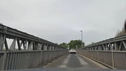
Bailey Bridge (Walton on Trent)
Bridge · 3.4 mi
Bridge in Staffordshire

Chetwynd Bridge
Bridge · 1.3 mi
Bridge in Edingale, Lichfield, Staffordshire, England, UK
Museums and landmarks238

Armed Forces Memorial
Monument and historic site · 1.0 mi
United Kingdom national memorial in Staffordshire

Polish Forces War Memorial:National Memorial Arboretum
Monument and historic site · 1.1 mi
War memorial in Staffordshire, England

Shot at Dawn Memorial
Monument and historic site · 1.2 mi
War memorial

226 more on the map.
Parks, trails and playgrounds26

National Memorial Arboretum
Park · 1.0 mi
British site of national remembrance
Croxall Road, Burton-on-Trent



14 more on the map.
Restaurants and cafes10



More about Alrewas
Geography
The village is beside the River Trent, 5 miles (8 km) northeast of Lichfield and 7 miles (11 km) southwest of Burton-on-Trent. The parish is bounded by the Trent to the north and east, and by field boundaries to the south and west. The A38 road passes the village, which is just inside the boundary of the National Forest.
Until 2009 Alrewas was part of the civil parish of Alrewas and Fradley. Fradley had begun as a hamlet in the ancient parish of Alrewas, and the civil parish was named to reflect Fradley's growth into a village. From 1 April 2009 Alrewas and Fradley have been two separate civil parishes. Near Alrewas are the villages of Wychnor, Barton-under-Needwood, Fradley and Kings Bromley. Diamond Bus service 12 links the village to Lichfield, Fradley and Burton.
Arts and culture
The village holds the biennial Alrewas Arts Festival every other summer. The first festival was in 2006, and it has become a much loved attraction in the village's calendar. It is an eight-day free festival that includes workshops, performances, exhibitions and events in Alrewas village. It features local artistic and artisan talents. The workshops range from silk painting to film making. There is fund raising including auctions and sales in the intermediate 2-year period to meet the festival's costs. It starts with a Craft Market and culminates in a final daytime to evening event of live music, comedy and interactive arts that attracts thousands of party-goers from surrounding villages and towns. The festival website has a wealth of information films and photographs from all previous festivals.
Each year the village hosts the Alrewas Show, which is a registered charity. It includes a walking carnival procession (formerly driven floats), galloping acrobatics, a falconry display, miniature steam display, Punch and Judy show, livestock display, fairground rides and attractions, trade stands, historic cars, farm machinery and music.
From the Wikipedia article Alrewas, under CC BY-SA 4.0.
Where to stay2
Churches and places of worship8
Gas and EV charging1
Schools, colleges and libraries2
All Saints Church of England Primary and Nursery School
School · Anglican
Furlong Close, Burton-on-Trent
Healthcare1
Map of Alrewas
250 places. The map loads OpenStreetMap tiles when you open it.
Getting there and nearby towns
East Midlands Airport (EMA) is the nearest airport with scheduled flights listed in OpenStreetMap, 19 miles away.
- Whittington 4 mi south, about 7 min by car
- Lichfield 5 mi southwest, about 8 min by car
- Burton upon Trent 7 mi northeast, about 11 min by car
- Tamworth 7 mi south, about 12 min by car
- Rugeley 8 mi west, about 13 min by car
- Burntwood 8 mi southwest, about 13 min by car
- Shenstone 8 mi southwest, about 12 min by car
- Abbots Bromley 8 mi northwest, about 13 min by car
- Swadlincote 9 mi east, about 14 min by car
- Moira 9 mi east, about 14 min by car
Drive times are estimates from straight-line distance, not routes.
Towns near Alrewas


Keep exploring
Local news
Headlines from INDB.
Reviews, tips and questions
Loading what members have shared...
Sources and licences
- GeoNames (CC BY 4.0): population, coordinates, regions and time zone
- Mapillary (see each image): photos
- OpenStreetMap contributors (ODbL 1.0): places, airports, map data
- Wikidata (CC0 1.0): elevation, founding date, time zone, website, landmarks and historic places
- Wikimedia Commons (see each image): photos
- Wikipedia (CC BY-SA 4.0): overview and history text
Photo credits
- 112 Main Street, Alrewas, Richard Law, CC BY-SA 2.0
- Chetwynd Bridge, Bs0u10e01, CC BY 3.0
- Armed Forces Memorial NMA, Bs0u10e01, CC BY-SA 3.0
- NMA Polish Service Men And Women Memorial, Mark Zawisza, CC BY-SA 3.0
- View over National Memorial Arboretum, NMAguide, CC BY 3.0
- Croxall Church St John, Geoff Pick, CC BY-SA 2.0
- Shot at dawn memorial 2, Noisette, CC BY-SA 3.0
- All Saints, Alrewas, Bs0u10e01, CC BY 3.0
- Shot at Dawn, National Memorial Arboretum (15), Harry Mitchell, CC BY 4.0
- Street-level photo, jamestait, CC BY-SA 4.0
- Street-level photo, adam2, CC BY-SA 4.0
- Street-level photo, adam2, CC BY-SA 4.0
- Street-level photo, adam2, CC BY-SA 4.0
- Street-level photo, southglos, CC BY-SA 4.0
- Street-level photo, jamestait, CC BY-SA 4.0

Page built November 10, 2026. Spotted a mistake? Tell us or suggest a place.