


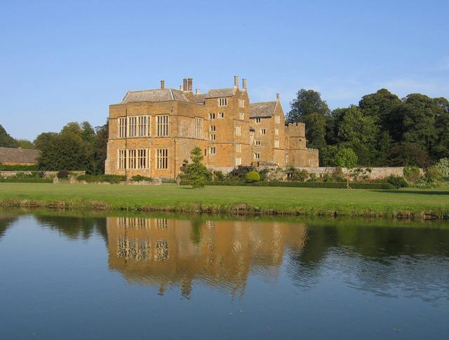


Why visit Banbury
Townapedia lists 17 museums and landmarks, 47 parks and trails, 149 places to eat, 11 places to stay and 4 attractions in and around town.
Highlights include Wykham Park Farm Shop, Cropredy Bridge, Banbury Museum and Broughton Castle.
Weather in Banbury
Forecast from MET Norway (CC BY 4.0). Full forecast
About Banbury
Banbury is an historic market town and civil parish on the River Cherwell in Oxfordshire, officially part of South East England.
From the Wikipedia article Banbury (this version), under CC BY-SA 4.0.
Travel tips from other travellers: Banbury on Wikivoyage (CC BY-SA 4.0).
Things to do4



Museums and landmarks17

Banbury Museum
Museum · 0.4 mi
Museum in Banbury, England, United Kingdom

Broughton Castle
Museum · 2.6 mi
Medieval manor house in Oxfordshire, England, UK



Banbury Castle
Monument and historic site · 0.4 mi
Archaeological site in Banbury, Cherwell, England, UK

Bloxham Village Museum
Museum · 3.4 mi
Local museum in Bloxham, England, United Kingdom
5 more on the map.
Parks, trails and playgrounds47

Adderbury Lakes
Park · 3.6 mi
Local nature reserve in Oxfordshire, England, UK
Farthinghoe Nature Reserve
Park · 4.0 mi
Nature reserve in the United Kingdom

35 more on the map.
Restaurants and cafes149
Pizza Hut
Restaurant · Pizza · 0.7 mi
Unit 15 Lockheed Close, Banbury
Su-Th 11:00-22:00; Fr,Sa 11:00-23:00

The Wine Vaults
Bar and pub
5-6 Parsons Street, Banbury
Mo 17:00-23:00, Tu 17:00-24:00, We,Th,Su 12:00-24:00, Fr,Sa 12:00-01:00

Caffè Nero
Cafe · Coffee Shop
95 High Street, Banbury
Mo-Fr 06:30-18:30; Sa 07:00-18:30; Su 07:30-18:00
Coffee#1
Cafe · Coffee Shop
Unit 22 Castle Quay Shopping Centre, Banbury
Mo-Fr 08:00-17:00; Sa 08:00-18:00; Su 09:00-17:00

New Mogul Indian Cuisine
Restaurant · Indian
58 Parsons Street, Banbury
Su-Th 17:30-23:00; Fr,Sa 17:30-23:30
The Easington
Bar and pub · Fish And Chips, Burger · 0.8 mi
135 Bloxham Road, Banbury
Mo-Su 12:00-00:00
Uprise Pizza
Restaurant · Pizza
54 - 56 Parsons Street, Banbury
Tu-Th 17:00-21:15; Fr 17:00-21:30; Sa 12:00-21:30; Su 12:00-20:00
Visit and Taste
Cafe · Polish
8 Butcher's Row, Banbury
We,Th 12:00-20:00; Fr,Sa 12:00-21:00; Su 12:00-18:00
Zushi
Restaurant · Japanese
12 Parsons Street, Banbury
Tu-Su 12:00-15:00, Tu-Th,Su 17:30-22:00, Fr,Sa 17:30-23:00
137 more on the map.
History
Archaeological evidence has been found for a British Iron Age settlement with circular buildings, dating back to 200 BC, in the Hennef Way area. Later there was a Roman villa at Wykham Park.
The area was settled by the Saxons around the late 5th century. It was a local centre for Anglo-Saxon settlement by the mid-6th century. Banbury developed in the Anglo-Saxon period under Danish influence, starting in the late 6th century. It was assessed at 50 hides in the Domesday survey and was then held by the Bishop of Lincoln.
The Saxons built Banbury on the west bank of the River Cherwell. On the opposite bank they built Grimsbury, which was formerly part of Northamptonshire. Another district, Neithrop, is one of the oldest areas in Banbury, having first been recorded as a hamlet in the 13th century.
Banbury stands at the junction of two ancient roads: Salt Way (used as a bridle path to the west and south of the town), its primary use being transport of salt; and Banbury Lane, which began near Northampton and is closely followed by the modern 22-mile-long (35 km) road. It continued through what is now Banbury's High Street and towards the Fosse Way at Stow-on-the-Wold. Banbury's medieval prosperity was based on wool.
Banbury Castle was built from 1135 by Alexander, Bishop of Lincoln, and survived into the Civil War in the 1640s, when it was besieged.
Read more of the history
During the Civil War, due to its proximity to Oxford, the King's capital, Banbury was at one stage a Royalist town, but the inhabitants were known to be strongly Puritan. The town later became pro-Parliamentarian, but the castle was manned by a Royalist garrison who supported King Charles I. The Reindeer Inn (now 'Ye Olde Reine Deer Inn') was reputedly used as a base by Oliver Cromwell, particularly in preparing for the Battle of Edge Hill in 1642. In 1645, Parliamentary troops were billeted in nearby Hanwell for nine weeks and villagers petitioned the Warwickshire Committee of Accounts to pay for feeding them. The castle was demolished after the war.
The opening of the Oxford Canal from Hawkesbury Junction to Banbury on 30 March 1778 gave the town a cheap and reliable supply of Warwickshire coal. In 1787 the Oxford Canal was extended southwards, finally opening to Oxford on 1 January 1790. The canal's main boat yard was the original outlay of today's Tooley's Boatyard. The railway reached Banbury in 1850; Merton Street station on the Buckinghamshire Railway to Bletchley opened in May 1850, followed by Bridge Street station, later renamed Banbury General, on the Great Western Railway in September 1850.
People's Park was set up as a private park in 1890 and opened in 1910, along with the adjacent bowling green.
The land south of the New Foscote Hospital in Calthorpe and Easington Farm were mostly open farmland until the early 1960s. The Ruscote estate, which now has a notable South Asian community, was expanded in the 1950s because of the growth of the town due to the London overspill and further grew in the mid-1960s.
British Railways closed Merton Street railway station and the Buckingham to Banbury line to passenger traffic at the end of 1960. Merton Street goods depot continued to handle livestock traffic for Banbury's cattle market until 1966, when this too was discontinued and the railway dismantled. In March 1962 Sir John Betjeman celebrated the line from Culworth Junction in his poem Great Central Railway, Sheffield Victoria to Banbury. British Railways closed this line too in 1966.
The main railway station, previously called Banbury General but now called simply Banbury, is now served by trains running from London Paddington via Reading and Oxford once daily, from London Marylebone via High Wycombe and Bicester onwards to Birmingham and Kidderminster and by CrossCountry Trains from Bournemouth and Reading to Birmingham, Manchester and Newcastle.
Banbury used to have a large cattle market. Situated on Merton Street in Grimsbury, for many decades, cattle and other farm animals were driven there on the hoof from as far as Scotland to be sold to feed the growing population of London and other towns. Since its closure in June 1998, a new housing development and Dashwood Primary School have been built on its site. The estate, which lies between Banbury and Hanwell, was built on the grounds of Hanwell Farm during 2005 and 2006.
The name 'Banburyshire' is sometimes used informally to describe the area centred on Banbury, claimed to include parts of Northamptonshire and Warwickshire as well as north Oxfordshire. Use of the term dates from the early to mid 19th century. It was common in the 19th century for market towns in England to describe their hinterland by tacking "shire" onto the town's name. "Stones Map of Banburyshire" held by the Centre of Banbury Studies was published in the 1870s or 1880s and it asserted that the term originated in the 1830s but no source is given for that assertion. In the 1850s magazine articles used "Banburyshire" or the hyphenated term "Banbury-shire". The Banburyshire Natural History Society was formed in 1881.
In the 20th century a number of books used the term "Banburyshire" in their titles, dating from the early 1960s.
The county of Oxfordshire has two main commercial centres, the city of Oxford itself that serves most of the south of the county, and Banbury that serves the north (such as Adderbury, Cropredy, Deddington, Wroxton, Great Bourton, and Bloxham) plus parts of the neighbouring counties of Northamptonshire and Warwickshire.
From the History section of Banbury on Wikipedia, under CC BY-SA 4.0.
More about Banbury
Geography
Banbury is in the Cherwell Valley with many hills in and around the town. Apart from the town centre, much of Banbury is on a slope and each entry into the town is downhill. Estates such as Bretch Hill and Hardwick are built on top of a hill and much of the town can be seen from both. Other notable hills include Crouch Hill, the more central Pinn Hill, and Strawberry Hill on the outskirts of Easington. Mine Hill and Rye Hill lie, along with many others, to the northeast, southeast and west of Banbury.
Banbury is located at the bank of the River Cherwell which sweeps through the town, going just east of the town centre with Grimsbury being the only estate east of the river. Banbury is at the northern extreme of the UK's South East England region, less than two miles (3 km) from the boundary with the East Midlands, and three miles (5 km) from that with the West Midlands. As such it has close cultural links with neighbouring Midlands towns such as Stratford-upon-Avon, Leamington Spa, and Warwick.
In 1998 and 2007, Banbury was subject to heavy flooding due to its location by the River Cherwell. Heavy clay and ironstone deposits deposits surround Banbury.
Education
One of the campuses of Activate Learning, Banbury and Bicester College, as well as one of the international campuses of Fairleigh Dickinson University at Wroxton Abbey are situated in Banbury. The town also has four secondary schools – North Oxfordshire Academy, Wykham Park Academy, Space Studio Banbury and Blessed George Napier Roman Catholic School – and a number of primary schools. Independent schools in Banbury include Tudor Hall and Al-Madina School.
From the Wikipedia article Banbury, under CC BY-SA 4.0.
Notable people from Banbury
 Richie HawtinEnglish-Canadian electronic musician and record producerPhoto: Raminta Malinauskaite, CC BY-SA 3.0
 Victoria PrentisBritish politicianPhoto: UK Government, CC BY 2.0
 Tim PlesterBritish actor and playwrightPhoto: Plesterdog, CC BY-SA 4.0
 Jorge GrantEnglish association football playerPhoto: Nottingham Forest F.C., CC0
 Will Brattracecar driverPhoto: Robk23oxf, CC BY-SA 3.0
 Ed WeeksBritish actorPhoto: iDominick, CC BY-SA 2.0
- Alan Lloyd Hodgkinphysiologist and biophysicist (1914-1998)
- Gary GlitterEnglish convicted child sex offender and former glam rock singer-songwriter and musician
- Richard CrossmanBritish Labour Party politician, author and editor (1907-1974)
- Chris TsangaridesBritish record producer (1956–2018)
- Rodney GouldBritish motorcycle racer (1943–2024)
- R. B. BraithwaiteEnglish philosopher and ethicist (1900–1990)
Born in Banbury, according to Wikidata (CC0). Each name links to its Wikipedia article.
Where to stay11
Churches and places of worship39
Shopping43
Gas and EV charging12
Schools, colleges and libraries33
Blessed George Napier Catholic School and Sixth Form
School · Roman Catholic · 1.0 mi
Addison Road, Banbury
Healthcare14
Map of Banbury
250 places. The map loads OpenStreetMap tiles when you open it.
Getting there and nearby towns
Oxford Airport (OXF) is the nearest airport with scheduled flights listed in OpenStreetMap, 16 miles away.
- Brackley 8 mi east, about 14 min by car
- Bicester 14 mi southeast, about 22 min by car
- Daventry 15 mi northeast, about 25 min by car
- Buckingham 16 mi east, about 25 min by car
- Royal Leamington Spa 17 mi northwest, about 28 min by car
- Kidlington 17 mi south, about 27 min by car
- Stratford-upon-Avon 18 mi northwest, about 29 min by car
- Warwick 18 mi northwest, about 29 min by car
- Witney 20 mi south, about 33 min by car
- Oxford 22 mi south, about 35 min by car
Drive times are estimates from straight-line distance, not routes.
Towns near Banbury


Keep exploring
Local news
Headlines from INDB.
Reviews, tips and questions
Loading what members have shared...
Sources and licences
- GeoNames (CC BY 4.0): population, coordinates, regions and time zone
- Mapillary (see each image): photos
- OpenStreetMap contributors (ODbL 1.0): places, airports, map data
- Wikidata (CC0 1.0): elevation, founding date, time zone, website, landmarks and historic places
- Wikimedia Commons (see each image): photos
- Wikipedia (CC BY-SA 4.0): overview and history text
Photo credits
- Banbury Town Hall, Tom Bastin A derivate work by MrPanyGoff, CC BY 2.0
- Banbury Museum - Oxford Canal, Banbury (8723264045), Elliott Brown from Birmingham, United Kingdom, CC BY 2.0
- Broughton castle2, David Stowell, CC BY-SA 2.0
- St. Mary's Church - Banbury, Jim Linwood, CC BY 2.0
- Banbury StJohnE WNW, Motacilla, CC BY-SA 4.0
- Horton Hospital, Banbury, Wipsenade at English Wikipedia, CC BY 3.0
- Tooley's Boatyard - Banbury, Jim Linwood, CC BY 2.0
- Tudor Hall School Main School 2, Johnfield1, CC BY-SA 3.0
- Banbury Cross - 2, Chris Evans, CC BY 2.0
- Drayton, Banbury church, Geoffrey Lloyd, CC BY-SA 2.0
- Grimsbury StLeonard west, Motacilla, CC BY-SA 4.0
- Neithrop StPaul south bus, Motacilla, CC BY-SA 4.0
- Street-level photo, laye, CC BY-SA 4.0
- Street-level photo, alexanderar, CC BY-SA 4.0
- Street-level photo, laye, CC BY-SA 4.0
- Street-level photo, editid, CC BY-SA 4.0
- Street-level photo, alexanderar, CC BY-SA 4.0
- Street-level photo, editid, CC BY-SA 4.0
- Street-level photo, editid, CC BY-SA 4.0
- Street-level photo, alexanderar, CC BY-SA 4.0
- Street-level photo, alexanderar, CC BY-SA 4.0
- Street-level photo, alexanderar, CC BY-SA 4.0


Page built November 10, 2026. Spotted a mistake? Tell us or suggest a place.