
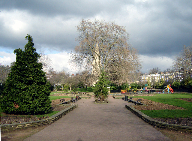


Barnsbury, United Kingdom
Barnsbury is a town of 10,000 people in England, United Kingdom.
Why visit Barnsbury
Townapedia lists 165 museums and landmarks, 69 parks and trails, 128 places to eat, 32 places to stay and 43 attractions in and around town.
Highlights include Bloomsbury Theatre, Little Angel Theatre, British Museum and Camden Market.
Weather in Barnsbury
Forecast from MET Norway (CC BY 4.0). Full forecast
About Barnsbury
Barnsbury is an area of north London in the London Borough of Islington, within the N1 and N7 postal districts.
From the Wikipedia article Barnsbury (this version), under CC BY-SA 4.0.
Photos of Barnsbury


Things to do43


Little Angel Theatre
Cinema and theater · 0.7 mi
13 Dagmar Passage, London
Mo 11:00-17:00; Tu-Su 11:00-15:00

Odeon Holloway
Cinema and theater · 1.3 mi
State-of-the-art chain cinema for blockbusters in 2-D or 3-D format, plus family and student deals.
419-427 Holloway Road, London



Vue Islington
Cinema and theater · 0.6 mi
36 Parkfield Street, London
Mo-Fr 09:30-24:00; Sa-Su 10:30-24:00
31 more on the map.
Museums and landmarks165


London Canal Museum
Museum · 0.5 mi
12-13 New Wharf Road, London
Tu-Su 10:00-16:30; PH Mo 10:00-16:30; Dec 23-Jan 01 Off


Conway Hall
Monument and historic site · 1.4 mi
Based in Holborn, Conway Hall is home to leading speakers and artists and is the landmark of London's independent intellectual,...
25 Red Lion Square, London

Estorick Collection
Museum · 0.7 mi
39a Canonbury Square, London
We-Sa 11:00-18:00; Th 11:00-20:00; Su 12:00-17:00

Grant Museum of Zoology
Museum · 1.4 mi
21 University Street, London
Tu-Fr 13:00-17:00; Sa 11:00-17:00; Su,Mo,PH off

153 more on the map.
Parks, trails and playgrounds69



Lonsdale Square Garden
Park · 0.4 mi
Lonsdale Square, London
Mo-Su 08:00-sunset
57 more on the map.
Restaurants and cafes128

Eat Tokyo
Restaurant · Japanese · 1.4 mi
50 Red Lion Street, London
Mo-Fr 12:00-15:00, 18:00-22:30; Sa 12:00-15:30, 17:30-22:30; Su...
North Sea Fish
Restaurant · Seafood · 1.1 mi
7-8 Leigh Street, London
Mo 05:00-09:30; Tu-Su 12:00-21:00

The Barrel Vault
Bar and pub · Burger, Italian Pizza, Curry, Pasta, Salad, Breakfast · 0.7 mi
Unit 23 The Circle, Saint Pancras Station, London
Mo-Th 06:30-00:00; Fr, Sa 06:30-01:00; Su 07:30-23:00

The Pineapple
Bar and pub · Thai · 1.3 mi
51 Leverton Street, London
Mo-Th 12:00-23:00; Fr-Sa 12:00-00:00; Su 12:00-22:30

Camden Head
Bar and pub · 0.7 mi
2 Camden Walk, London
Mo-Tu, Th, Su 12:00-24:00; We 12:00-23:00; Fr-Sa 12:00-01:00


Crown & Anchor
Bar and pub · 1.3 mi
137 Drummond Street, London
Mo-We 12:00-23:00; Th-Fr 12:00-00:00; Sa 10:00-00:00; Su 10:00-22:30


Hope & Anchor
Bar and pub · 0.6 mi
207 Upper Street, London
Mo-Th 12:00-23:00; Fr-Sa 12:00-01:00; Su 12:00-23:00

Marquess Tavern
Bar and pub · 0.9 mi
32 Canonbury Street, London
Mo-Th 12:00-23:00; Fr-Sa 12:00-24:00; Su 12:00-22:00


116 more on the map.
History
The name is a syncopated form of Bernersbury (1274), being so called after the Berners family: powerful medieval manorial lords who gained ownership of a large part of Islington after the Norman Conquest. The area of Barnsbury was predominantly rural until the early 19th century.
By the end of the 18th century, Barnsbury, like other parts of Islington, was regarded as an attractive part-rural suburb by the comparatively wealthy people wanting to move out of the cramped City of London and industrial Clerkenwell. The area is close to the city, and had strong local trade in its position as the first staging post for travellers making the journey from London to the north, and with considerable agricultural traffic and cattle driving to the nearby Smithfield cattle market in the city.
Barnard Park, consisting of 10 acres (4 hectares) including a large area of football pitches, was created in 1967 on an area of housing that had been bombed during World War Two, and was named after former Islington Mayor Cllr George Barnard.
From the History section of Barnsbury on Wikipedia, under CC BY-SA 4.0.
Notable people from Barnsbury
- Eric Forbes-RobertsonBritish artist (1865-1935)
- John Hollwaychemist and inventor (1841-1907)
Born in Barnsbury, according to Wikidata (CC0). Each name links to its Wikipedia article.
Where to stay32
Churches and places of worship54
Shopping62
Gas and EV charging22
Schools, colleges and libraries31
Healthcare31
MSI Reproductive Choices Local Treatment Centre
Clinic and pharmacy · 1.5 mi
108 Whitfield Street, London
Map of Barnsbury
250 places. The map loads OpenStreetMap tiles when you open it.
Getting there and nearby towns
London City Airport (LCY) is the nearest airport with scheduled flights listed in OpenStreetMap, 7 miles away.
- Islington 1 mi southeast, about 1 min by car
- King's Cross 1 mi south, about 1 min by car
- Highbury 1 mi northeast, about 2 min by car
- Camden Town 1 mi west, about 2 min by car
- Chalk Farm 1 mi west, about 2 min by car
- Holborn 2 mi south, about 3 min by car
- London 2 mi south, about 4 min by car
- Archway 2 mi north, about 3 min by car
- Belsize Park 2 mi west, about 4 min by car
- Highgate 3 mi northwest, about 4 min by car
Drive times are estimates from straight-line distance, not routes.
Towns near Barnsbury


Keep exploring
Local news
Headlines from INDB.
Reviews, tips and questions
Loading what members have shared...
Sources and licences
- GeoNames (CC BY 4.0): population, coordinates, regions and time zone
- Mapillary (see each image): photos
- OpenStreetMap contributors (ODbL 1.0): places, airports, map data
- Wikidata (CC0 1.0): elevation, founding date, time zone, website, landmarks and historic places
- Wikimedia Commons (see each image): photos
- Wikipedia (CC BY-SA 4.0): overview and history text
Photo credits
- Thornhill square 1, "Fin Fahey", CC BY-SA 2.5
- Barnsbury Wood 6, Dudley Miles, CC BY-SA 3.0
- Meltdown, Barnsbury, N1 - 2025-09-02, Ewan Munro, CC BY-SA 4.0
- Meltdown, Barnsbury, N1 - 2013-12-29, Ewan Munro, CC BY-SA 2.0
- Islington, Barnsbury, N1 - 2008-07-24, Ewan Munro, CC BY-SA 2.0
- Prince, Barnsbury, N1 (6023637010), Ewan Munro from London, UK, CC BY-SA 2.0
- Kennedys, Barnsbury, N1 (3025123697), Ewan Munro from London, UK, CC BY-SA 2.0
- Kennedy's, Barnsbury, Courage cockerel 2008-07-24, Ewan Munro, CC BY-SA 2.0
- Kennedy's, Barnsbury, N1 - 2025-09-02, Ewan Munro, CC BY-SA 4.0
- Kennedy's, Barnsbury, N1 - 2013-12-29, Ewan Munro, CC BY-SA 2.0
- Barnsbury Wood 5, Dudley Miles, CC BY-SA 3.0
- British Museum from NE 2 (cropped), Ham, CC BY-SA 3.0
- British Library + St Pancras 7527-31hug, Patche99z, CC BY-SA 3.0
- Marx Memorial Library 37a Clerkenwell Green, Unknown author, CC BY-SA 2.0
- London Emirates Stadium arsenal, Arne Müseler, CC BY-SA 3.0 de
- Bloomsbury Square, Schlaier, Public domain
- London - Camden Town by Horst Michael Lechner, Horst Michael Lechner, CC BY-SA 3.0
- Coram's 7274, ClemRutter, CC BY-SA 4.0
- Great Ormond Street Hospital, Nigel Cox, CC BY-SA 2.0
- Sadler's Wells Theatre (September 2015), Sadler's Wells Theatre, CC BY-SA 4.0
- Conway Hall Entrance 004, StewE17, CC BY-SA 4.0
- NHNN and ION, Montano336, CC BY-SA 3.0
- Postal Museum (London) Air Mail Post Box, Gaius Cornelius, CC BY-SA 4.0
- University College Hospital - New Building - London - 020504, Tagishsimon ( talk ) ( Uploads ), CC BY-SA 3.0
- UCL Bloomsbury Theatre, Frankieroberto at English Wikipedia, Public domain
- Camley Street Natural Park, Unknown author, CC BY-SA 2.5
- Cittie of Yorke pub, London - 2023-01-27, The wub, CC BY-SA 4.0
- Cyberdog shop 2009, Fenvoe, CC BY 3.0
- Estorick Collection, Luke McKernan, CC BY-SA 2.0
- Gays the Word, Ross Burgess, CC BY-SA 3.0
- Horse Hospital, Colonnade, Bloomsbury, London WC1N 1JD 01, Edwardx, CC BY-SA 4.0
- London Canal Museum TQ3083, Oxyman, CC BY-SA 2.0
- St John's Gate, Clerkenwell - London., Jim Linwood, CC BY 2.0
- St Pancras Railway Station 2012-06-23, Colin, CC BY-SA 3.0
- St James Church, Clerkenwell in London, Jim, CC BY 2.0
- St Luke, Oseney Crescent, Mike Quinn, CC BY-SA 2.0
- New St Pancras Parish Church, Original uploader was Sue Wallace at en.wikipedia, CC BY-SA 2.0
- Screen on the Green 14 Sept. 2016, Philafrenzy, CC BY-SA 4.0
- The Wellcome Building, David Samuel, User:Hellodavey1902, CC BY-SA 3.0
- DanishChLondon, Matthew Ross, Public domain
- Crown and Anchor, Somers Town, NW1 (2630808524), Ewan Munro from London, UK, CC BY-SA 2.0
- Zetter Hotel 2, Mx. Granger, CC0
- Islington north library (29053629081), JuliaC2006 from Rochester, UK, CC BY 2.0
- Islington Central Library (16237236403), DncnH from Nottingham, UK, CC BY 2.0
- London (46461655895), Fred Romero from Paris, France, CC BY 2.0
- Holloway Odeon, Holloway, N7 (3750259188), Ewan Munro from London, UK, CC BY-SA 2.0
- 50, Red Lion Street, Jwslubbock, CC BY-SA 4.0
- 64, Eversholt Street, Frombowen, CC BY-SA 4.0
- Waterstones Bookshop - Facade, Stefan Wolmarans, CC BY-SA 4.0
- Hilton London Euston, APK, CC BY 4.0
- 51, Lambs Conduit Street, Jwslubbock, CC BY-SA 4.0
- Gas holder 0656, Photograph by Clem Rutter, Rochester, Kent. ( www.clemrutter.net )., CC BY-SA 3.0
- Renoir Cinema, The Brunswick Centre - panoramio, N19±, CC BY-SA 3.0
- J. Sainsbury's supermarket Camden Road, London, Philafrenzy, CC BY-SA 4.0
- DoubleTree by Hilton Hotel London - West End, Frombowen, CC BY-SA 4.0
- Barrel Vault, St Pancras International Station, N1, Ewan-M, CC BY-SA 2.0
- Camden Gardens 2020 front, TheFrog001, CC0
- At London 2025 975, Photograph by Mike Peel ( www.mikepeel.net )., CC BY-SA 4.0
- Mercure London Bloomsbury Hotel, Frombowen, CC BY-SA 4.0
- Collinge & Clark storefront, CJJ2501, CC0
- West Lodge in Euston Square (Southwest View - 02), Doyle of London, CC BY-SA 4.0
- Norfolk Arms, St Pancras, WC1, Ewan Munro from London, UK, CC BY-SA 2.0
- Charles Dickens Museum London, Dickens Museum, CC BY-SA 4.0
- Grant Museum of Zoology (9201048849), DAVID HOLT from London, England, CC BY-SA 2.0
- Hope & Anchor pub Upper Street, Islington, Philafrenzy, CC BY-SA 4.0
- St Peter's church 2020, GrindtXX, CC BY-SA 4.0
- London MMB A0 Royal National Hotel, mattbuck ( category ), CC BY-SA 3.0
- Barnsbury Square - gardens, User:Masato.harada, CC BY-SA 4.0
- John Wright MBE (1905-1991) master puppeteer founded the Little Angel Theatre here in 1961, Spudgun67, CC BY-SA 4.0
- Paul Mccartney Roundhouse, Richard from Peterborough, United Kingdom, CC BY 2.0
- St Joan, Shaw Theatre, Euston Road, Keith Grant (sculpture) / Stu's Images (photo), CC BY-SA 3.0
- Keystone with pineapple (15626069846), Images George Rex from London, England, CC BY-SA 2.0
- GOC Ally Pally to Kings Cross 111 Marquess Tavern, Canonbury (40172748492), Peter O'Connor aka anemoneprojectors, CC BY-SA 2.0
- Street-level photo, sk53bis, CC BY-SA 4.0
- Street-level photo, erias, CC BY-SA 4.0
- Street-level photo, sk53, CC BY-SA 4.0
- Street-level photo, pbb, CC BY-SA 4.0
- Street-level photo, matth81, CC BY-SA 4.0
- Street-level photo, erias, CC BY-SA 4.0
- Street-level photo, gness, CC BY-SA 4.0
- Street-level photo, gness, CC BY-SA 4.0
- Street-level photo, erias, CC BY-SA 4.0
- Street-level photo, erias, CC BY-SA 4.0
- Street-level photo, southglos, CC BY-SA 4.0
- Street-level photo, cyclestreets, CC BY-SA 4.0
- Street-level photo, asturksever, CC BY-SA 4.0
- Street-level photo, erias, CC BY-SA 4.0
- Street-level photo, erias, CC BY-SA 4.0
- Street-level photo, erias, CC BY-SA 4.0
- Street-level photo, Semir_Mapillary, CC BY-SA 4.0
- Street-level photo, gness, CC BY-SA 4.0
- Street-level photo, smsm1, CC BY-SA 4.0


Page built November 10, 2026. Spotted a mistake? Tell us or suggest a place.