
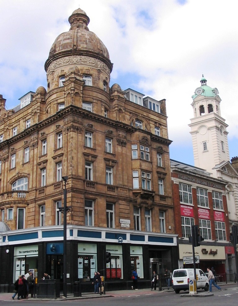


Islington, United Kingdom
Islington is a city of 319,143 people in England, United Kingdom.
Why visit Islington
Townapedia lists 150 museums and landmarks, 60 parks and trails, 120 places to eat, 30 places to stay and 74 attractions in and around town.
Highlights include Bloomsbury Theatre, His Majesty's Theatre, British Museum and Benjamin Franklin House.
Weather in Islington
Forecast from MET Norway (CC BY 4.0). Full forecast
About Islington
Islington is an inner-city area of north London, England, within the wider London Borough of Islington. It is a mainly residential district of Inner London, extending from Islington's High Street to Highbury Fields and Regent's Canal, encompassing the area around the busy High Street, Upper Street, Essex Road, and Southgate Road to the east.
From the Wikipedia article Islington (this version), under CC BY-SA 4.0.
Travel tips from other travellers: Islington on Wikivoyage (CC BY-SA 4.0).
Photos of Islington


Things to do74


62 more on the map.
Museums and landmarks150


Dr Johnson's House
Museum · 1.5 mi
17 Gough Square, London
Oct-Apr: Mo-Sa 11:00-17:00; May-Sep: Mo-Sa 11:00-17:30



The Museum of Philatelic History
Museum · 2.3 mi
The Museum of Philatelic History at the Royal Philatelic Society London holds a collection of internationally significant objects. The...
41 Devonshire Place, London
Mo-Fr 09:30-16:30
ARTE DELUX
Museum · 1.9 mi
Private art gallery, by appointment
Laurence Pountney Hill, London
Mo-Fr 09:00-18:00
138 more on the map.
Parks, trails and playgrounds60

The Castle Climbing Centre
Sports field and stadium · 2.1 mi
Engine House of Metropolitan Water Board
Green Lanes, London
Mo-Fr 08:00-22:00, Sa-Su 09:00-20:00


Victoria Embankment Gardens
Park · 2.1 mi
Victoria Embankment, London
Jan 01-Feb 15 08:30-16:30,Feb 16-Feb 29 08:30-17:30,Mar 01-Mar...



48 more on the map.
Restaurants and cafes120

George Inn
Bar and pub · 2.3 mi
75-77 Borough High Street, London
Mo-Th 11:00-23:00; Fr-Sa 11:00-00:00; Su 12:00-22:30


The Blackfriar
Bar and pub · 1.7 mi
174 Queen Victoria Street, London
Mo-Tu, Sa 11:00-23:00; We-Fr 11:00-23:30; Su 12:00-22:30


The Old Bank of England
Bar and pub · 1.6 mi
194 Fleet Street, London
Mo-We 11:30-22:00; Th-Fr 11:30-23:00; Sa 11:30-22:00; Su 12:00-20:00

Commercial Tavern
Bar and pub · Pizza · 1.5 mi
142 Commercial Street, London
Mo-Sa 12:00-23:00; Su 12:00-22:30

Eat Tokyo
Restaurant · Japanese · 1.3 mi
50 Red Lion Street, London
Mo-Fr 12:00-15:00, 18:00-22:30; Sa 12:00-15:30, 17:30-22:30; Su...

Green Man
Bar and pub · Fish And Chips · 2.0 mi
57 Berwick Street, London
Mo-We 11:00-23:30; Th-Sa 10:00-01:00; Su 10:00-22:30


Hoop and Grapes
Bar and pub · Local · 2.0 mi
47 Aldgate High Street, London
Su-Fr 12:00-23:30; Sa 11:00-18:00

Indian YMCA
Restaurant · Indian · 1.8 mi
41 Fitzroy Street, London
Mo-Fr 07:30-09:15, 12:00-15:00; Sa-Su 07:30-09:15, 12:00-14:00
108 more on the map.
History
The manor of Islington was named by the Saxons Giseldone (1005), then Gislandune (1062). The name means "Gīsla's hill" from the Old English personal name Gīsla and dun ("hill", "down"). The name later mutated to Isledon, which remained in use well into the 17th century when the modern form arose. The manor, which was served by the ancient parish of Islington, later sub-divided, with new estates such as Neweton Berewe, Bernersbury, Hey-bury and Canonesbury – names first recorded in the 13th and 14th centuries) co-existing with the rump of the manor of Islington. The ancient parish of Islington continued to serve the rump manor of Islington and also the various manors that had broken away from it.
From the Middle Ages until the late 19th century, Islington was a parish of the hundred of Ossulstone, in the county of Middlesex.
Read more of the history
Some roads on the edge of the area, including Essex Road, were known as streets by the medieval period, possibly indicating a Roman origin, but little physical evidence remains. In the 14th century, the Great North Road from the City of London's Aldersgate came into use, leading north to York and Edinburgh. This was along the line of modern Upper Street, with a toll gate at The Angel, Islington, defining the extent of the village. The Back Road, the modern Liverpool Road, was primarily a drovers' road where cattle would be rested before the final leg of their journey to Smithfield. Pens and sheds were erected along this road to accommodate the animals.
The first recorded church, St Mary's, was erected in the twelfth century and was replaced in the fifteenth century. Islington lay on the estates of the Bishop of London and the Dean and Chapter of St Pauls. There were substantial medieval moated manor houses in the area, principally at Canonbury and Highbury. In 1548, there were 440 communicants listed and the rural atmosphere, with access to the City and Westminster, made it a popular residence for the rich and eminent. The local inns harboured many fugitives and sheltered recusants.
The hill on which Islington stands has long supplied the City of London with water, the first projects drawing water through wooden pipes from the many springs that lay at its foot, in Finsbury. These included Sadler's Wells, London Spa and Clerkenwell.
By the 17th century these traditional sources were inadequate to supply the growing population and plans were laid to construct a waterway, the New River, to bring fresh water from the source of the River Lea, in Hertfordshire to New River Head, below Islington in Finsbury. The river was opened on 29 September 1613 by Sir Hugh Myddelton, the constructor of the project. His statue still stands where Upper Street meets Essex Road. The course of the river ran to the east of Upper Street, and much of its course is now covered and forms a linear park through the area.
The Regent's Canal passes through Islington, for much of which in an 886-metre (2,907 ft) tunnel that runs from Colebrook Row east of the Angel, to emerge at Muriel Street near Caledonian Road. The stretch is marked above with a series of pavement plaques so walkers may find their way from one entrance to the other. The area of the canal east of the tunnel and north of the City Road was once dominated by much warehousing and industry surrounding the large City Road Basin and Wenlock Basin. Those old buildings that survive here are now largely residential or small creative work units. This stretch has an old double-fronted pub The Narrowboat, one side accessed from the towpath.
The canal was constructed in 1820 to carry cargo from Limehouse into the canal system. There is no tow-path in the tunnel so bargees had to walk their barges through, braced against the roof. Commercial use of the canal has declined since the 1960s.
In the 17th and 18th centuries the availability of water made Islington a good place for growing vegetables to feed London. The manor became a popular excursion destination for Londoners, attracted to the area by its rural feel. Many public houses were therefore built to serve the needs of both the excursionists and travellers on the turnpike. By 1716, there were 56 ale-house keepers in Upper Street, also offering pleasure and tea gardens, and activities such as archery, skittle alleys and bowling. By the 18th century, music and dancing were offered, together with billiards, firework displays and balloon ascents. The King's Head Tavern, now a Victorian building with a theatre, has remained on the same site, opposite the parish church, since 1543. The founder of the theatre, Dan Crawford, who died in 2005, disagreed with the introduction of decimal coinage. For twenty-plus years after decimalisation (on 15 February 1971), the bar continued to show prices and charge for drinks in pre-decimalisation currency.
By the 19th century many music halls and theatres were established around Islington Green. One such was Collins's Music Hall, the remains of which are now partly incorporated into a bookshop. The remainder of the Hall has been redeveloped into a new theatre, with its entrance at the bottom of Essex Road. It stood on the site of the Landsdowne Tavern, where the landlord had built an entertainment room for customers who wanted to sing (and later for professional entertainers). It was founded in 1862 by Samuel Thomas Collins Vagg and by 1897 had become a 1,800-seat theatre with 10 bars. The theatre suffered damage in a fire in 1958 and has not reopened. Between 92 and 162 acts were put on each evening and performers who started there included Marie Lloyd, George Robey, Harry Lauder, Harry Tate, George Formby, Vesta Tilley, Tommy Trinder, Gracie Fields, Tommy Handley and Norman Wisdom.
From the History section of Islington on Wikipedia, under CC BY-SA 4.0.
More about Islington
Education
According to latest figures published by the Department for Education, there are 47 primary and 10 state-funded secondary schools in Islington.
From the Wikipedia article Islington, under CC BY-SA 4.0.
Notable people from Islington
 Charles Scott SherringtonEnglish footballer, neurophysiologist and Nobel Prize recipient (1857–1952)Photo: Unknown author Unknown author, CC BY 4.0
 Alan ParkerBritish filmmaker (1944–2020)Photo: Lisa Moran Parker, CC BY-SA 1.0
 Henry Hallett DaleEnglish pharmacologist, Nobel laureate (1875–1968)Photo: Michieli, CC BY 4.0
 Emily WatsonEnglish actress (born 1967)Photo: Raph_PH, CC BY 4.0
 Leona LewisBritish singer (born 1985)Photo: Daltoncitys, CC BY-SA 4.0
 Asa ButterfieldEnglish actorPhoto: https://flickr.com/photos/greg2600, CC BY-SA 2.0
 Jonny BucklandBritish guitarist (born 1977)Photo: Raph_PH, CC BY 2.0
 Peter EbdonEnglish snooker playerPhoto: Benutzer:Bill da Flute, CC BY-SA 3.0
 Little SimzBritish rapperPhoto: JoshPopov, CC BY 4.0
- Adewale Akinnuoye-AgbajeEnglish actor
- Mary KingsleyBritish ethnographer, scientific writer and explorer (1862–1900)
- Adebayo AkinfenwaEnglish professional association footballer
Born in Islington, according to Wikidata (CC0). Each name links to its Wikipedia article.
Where to stay30
Churches and places of worship60
Shopping60
Gas and EV charging24
Schools, colleges and libraries32
Healthcare23
MSI Reproductive Choices Local Treatment Centre
Clinic and pharmacy · 1.8 mi
108 Whitfield Street, London
Map of Islington
250 places. The map loads OpenStreetMap tiles when you open it.
Getting there and nearby towns
London City Airport (LCY) is the nearest airport with scheduled flights listed in OpenStreetMap, 7 miles away.
- London 2 mi southwest, about 3 min by car
- City of Westminster 3 mi southwest, about 5 min by car
- Tottenham 5 mi north, about 8 min by car
- Walthamstow 5 mi northeast, about 8 min by car
- Sutton 14 mi south, about 22 min by car
- Watford 15 mi northwest, about 24 min by car
- Slough 21 mi west, about 34 min by car
- Woking 25 mi southwest, about 40 min by car
- Luton 27 mi northwest, about 44 min by car
- Maidstone 33 mi southeast, about 52 min by car
Drive times are estimates from straight-line distance, not routes.
Towns near Islington


Keep exploring
Local news
Headlines from INDB.
Reviews, tips and questions
Loading what members have shared...
Sources and licences
- GeoNames (CC BY 4.0): population, coordinates, regions and time zone
- Mapillary (see each image): photos
- OpenStreetMap contributors (ODbL 1.0): places, airports, map data
- Wikidata (CC0 1.0): elevation, founding date, time zone, website, landmarks and historic places
- Wikimedia Commons (see each image): photos
- Wikipedia (CC BY-SA 4.0): overview and history text
Photo credits
- AngelIslington, The original uploader was Skyring at English Wikipedia ., CC BY-SA 3.0
- Collins Music Hall - 10-11 Islington Green Islington London N1 2XH, Spudgun67, CC BY-SA 4.0
- Metal soldier at Islington Green War Memorial, Matt Brown, CC BY 2.0
- Playtime, Islington, N1 (5273701492), Ewan Munro from London, UK, CC BY-SA 2.0
- Cuba Libre and Bar Havana, Islington, N1 (3131892616), Ewan Munro from London, UK, CC BY-SA 2.0
- Browns, Islington, N1 (2447266004), Ewan Munro from London, UK, CC BY-SA 2.0
- Pitcher and Piano, Islington, N1, Ewan-M, CC BY-SA 2.0
- Ladybird, Islington, N1, Ewan-M, CC BY-SA 4.0
- Ladybird, Islington, N1 (2446445215), Ewan Munro from London, UK, CC BY-SA 2.0
- British Museum from NE 2 (cropped), Ham, CC BY-SA 3.0
- British Library + St Pancras 7527-31hug, Patche99z, CC BY-SA 3.0
- Guildhall, Londres, Inglaterra, 2014-08-11, DD 139, Diego Delso, CC BY-SA 4.0
- Marx Memorial Library 37a Clerkenwell Green, Unknown author, CC BY-SA 2.0
- St Pauls aerial (cropped), Mark Fosh, CC BY 2.0
- Bank of England Building, London, UK - Diliff, Diliff, CC BY-SA 3.0
- Church of St Dunstan in the West 20130414 016, Elisa.rolle, CC BY-SA 3.0
- 2008 Haymarket Theatre, Kbthompson at English Wikipedia, CC BY-SA 3.0
- Somerset House, Strand, Stephen Richards, CC BY-SA 2.0
- Regent's Park London, Tom Page from London, UK, CC BY-SA 2.0
- Langham london, The Langham, London, CC BY-SA 3.0
- London - Camden Town by Horst Michael Lechner, Horst Michael Lechner, CC BY-SA 3.0
- Royal Academy of Music, London W1, Philafrenzy, CC BY 2.0
- His Majesty’s Theatre London August 2023, AirshipJungleman29, CC BY-SA 4.0
- Waldorf Hotel 2, No machine-readable author provided. Edward assumed (based on copyright claims)., Public domain
- Walking in Finsbury Park, Hjuk at en.wikipedia, CC BY-SA 3.0
- Aldwych Theatre 3, No machine-readable author provided. Edward assumed (based on copyright claims)., Public domain
- Lambeth, London, UK - panoramio (124), joinai, CC BY 3.0
- St Olave Church, Lonpicman, CC BY-SA 3.0
- Liberty of London, habitatgirl, CC BY 2.0
- LyricLondon, KF, Public domain
- NHNN and ION, Montano336, CC BY-SA 3.0
- University College Hospital - New Building - London - 020504, Tagishsimon ( talk ) ( Uploads ), CC BY-SA 3.0
- Bankside Gallery (2), the wub, CC BY-SA 3.0
- Church of St Katherine Cree, 2001, Elisa.rolle, CC BY-SA 3.0
- Apollo Theatre, February 2022, Magic Goes Wrong, Richard Nevell, CC BY-SA 4.0
- Benjamin Franklin House, 36 Craven Street, London, Ridiculopathy, CC0
- UCL Bloomsbury Theatre, Frankieroberto at English Wikipedia, Public domain
- Camley Street Natural Park, Unknown author, CC BY-SA 2.5
- Csquare77, Danny Robinson, CC BY-SA 2.0
- Cross Bones, Southwark, London, September 2014, Matt Brown, CC BY 2.0
- Cyberdog shop 2009, Fenvoe, CC BY 3.0
- Dr. Johnson's House, Jim Linwood, CC BY 2.0
- Duchess Theatre 1, User:Edward, Public domain
- Quo Vadis, Soho, W1 (2588280146), Ewan Munro from London, UK, CC BY-SA 2.0
- Simpson 40418, gillfoto, CC BY-SA 4.0
- St Pancras Railway Station 2012-06-23, Colin, CC BY-SA 3.0
- London clink prison museum 20050521, Sir James, CC BY-SA 3.0
- Victoria Embankment Gardens, Alexrk2, CC BY-SA 3.0
- The George Inn 1, Ewan Munro from London, UK, CC BY-SA 2.0
- The Black Friar (16634557733), It's No Game, CC BY 2.0
- Hoop and Grapes, Aldgate, EC3 (2581221888), Ewan Munro from London, UK, CC BY-SA 2.0
- Aerial photo of the The Castle Climbing Centre in Stoke Newington, Hackney, London (2), Jonty Wareing, CC BY-SA 4.0
- Weymouth Street Hospital 09, Edward, CC BY-SA 4.0
- Commercial Tavern, Spitalfields, E1 (2417457038), Ewan Munro from London, UK, CC BY-SA 2.0
- House on Cockspur Street London, Ricardalovesmonuments, CC BY-SA 4.0
- 1192681 II THE OLD BANK OF ENGLAND London 20250615 0001, Tilman2007, CC BY-SA 4.0
- Islington north library (29053629081), JuliaC2006 from Rochester, UK, CC BY 2.0
- Islington Central Library (16237236403), DncnH from Nottingham, UK, CC BY 2.0
- 2 St Mark Street E1, Bobulous, CC BY-SA 4.0
- 50, Red Lion Street, Jwslubbock, CC BY-SA 4.0
- 1 Colville Place, Fitzrovia, August 2023, No Swan So Fine, CC BY-SA 4.0
- Flying Horse Public House, Jwslubbock, CC BY-SA 4.0
- Green Man, Soho, W1 (2534865794), Ewan Munro from London, UK, CC BY-SA 2.0
- Crowne Plaza hotel, Blackfriars House, New Bridge St, London 03, Paul the Archivist, CC BY-SA 4.0
- Picturehouse Central, Piccadilly Circus, W1 (18234385723), Ewan Munro from London, UK, CC BY-SA 2.0
- Hackney Picturehouse, Hackney, E8 (8026044949), Ewan Munro from London, UK, CC BY-SA 2.0
- J. Sainsbury's supermarket Camden Road, London, Philafrenzy, CC BY-SA 4.0
- Dalston CLR James Library (7652771398), secretlondon123 from London, England, CC BY-SA 2.0
- Bandstand At Boundary Street Garden, Jwslubbock, CC BY-SA 4.0
- Camden Gardens 2020 front, TheFrog001, CC0
- Foyles, Charing Cross Road (April 2015) (cropped), Chris Sampson, CC BY 2.0
- Collinge & Clark storefront, CJJ2501, CC0
- St Mary le Bow, Bellminsterboy, CC BY-SA 4.0
- St Bartholomew-the-Great, 2025-02-28 (cropped), Matt Brown, CC BY 2.0
- Charles Dickens Museum London, Dickens Museum, CC BY-SA 4.0
- Lyceum Theatre 1, The Lud, Public domain
- St. Helen's Bishopsgate, Wychester, CC BY-SA 4.0
- St Mary Abchurch towards organ, London, UK - Diliff, Diliff, CC BY-SA 3.0
- St Peter's church 2020, GrindtXX, CC BY-SA 4.0
- Covent Garden, Corpus Christi Catholic Church, chancel, AndyScott, CC BY-SA 4.0
- John Wright MBE (1905-1991) master puppeteer founded the Little Angel Theatre here in 1961, Spudgun67, CC BY-SA 4.0
- The Gielgud Theatre (5152149396), Tony Hisgett from Birmingham, UK, CC BY 2.0
- Indian YMCA London (2), Philafrenzy, CC BY-SA 4.0
- Statue of Sir Arthur Harris outside St Clement Danes, Greenshed, Public domain
- Stained glass of Southwark in Christ Church, Southwark 2025-03-13, Matt Brown, CC BY 2.0
- Blue Shutters above Stanfords Mercer Walk 2024-05-14, Tony Hisgett, CC BY 2.0
- Street-level photo, ris, CC BY-SA 4.0
- Street-level photo, sk53bis, CC BY-SA 4.0
- Street-level photo, sk53bis, CC BY-SA 4.0
- Street-level photo, erias, CC BY-SA 4.0
- Street-level photo, jris, CC BY-SA 4.0
- Street-level photo, ris, CC BY-SA 4.0
- Street-level photo, kieran, CC BY-SA 4.0
- Street-level photo, erias, CC BY-SA 4.0
- Street-level photo, tommorris, CC BY-SA 4.0
- Street-level photo, gness, CC BY-SA 4.0
- Street-level photo, chuck, CC BY-SA 4.0
- Street-level photo, kieran, CC BY-SA 4.0
- Street-level photo, erias, CC BY-SA 4.0
- Street-level photo, pbb, CC BY-SA 4.0
- Street-level photo, asturksever, CC BY-SA 4.0
- Street-level photo, erias, CC BY-SA 4.0
- Street-level photo, erias, CC BY-SA 4.0
- Street-level photo, NatchaponJ, CC BY-SA 4.0
- Street-level photo, erias, CC BY-SA 4.0
- Street-level photo, erias, CC BY-SA 4.0
- Street-level photo, zymurgic, CC BY-SA 4.0
- Street-level photo, NatchaponJ, CC BY-SA 4.0
- Street-level photo, ris, CC BY-SA 4.0


Page built November 10, 2026. Spotted a mistake? Tell us or suggest a place.