


Chalk Farm, United Kingdom
Chalk Farm is a town of 24,977 people in England, United Kingdom.
Why visit Chalk Farm
Townapedia lists 147 museums and landmarks, 73 parks and trails, 134 places to eat, 34 places to stay and 41 attractions in and around town.
Highlights include Bloomsbury Theatre, Hampstead Theatre, Camden Arts Centre and Camden Market.
Weather in Chalk Farm
Forecast from MET Norway (CC BY 4.0). Full forecast
About Chalk Farm
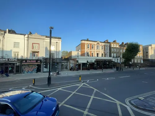
Chalk Farm is an urban district lying immediately north of Camden Town, in the London Borough of Camden.
From the Wikipedia article Chalk Farm (this version), under CC BY-SA 4.0.
Photos of Chalk Farm


Things to do41



29 more on the map.
Museums and landmarks147

Camden Arts Centre
Museum · 1.5 mi
52 Arkwright Road, London
Mo off; Tu-We,Fr-Su 11:00-18:00; Th 11:00-21:00


London Canal Museum
Museum · 1.4 mi
12-13 New Wharf Road, London
Tu-Su 10:00-16:30; PH Mo 10:00-16:30; Dec 23-Jan 01 Off


Abbey Road Studios
Monument and historic site · 1.4 mi
EMI Recording Studios, St. John's Wood, were established in November 1931 by The Gramophone Company, a predecessor of British music...
3 Abbey Road, London


Grant Museum of Zoology
Museum · 1.5 mi
21 University Street, London
Tu-Fr 13:00-17:00; Sa 11:00-17:00; Su,Mo,PH off

London King's Cross Railway Station
Monument and historic site · 1.4 mi
Euston Road, London
Mo-Fr 05:00-25:40; Sa 05:00-25:11; Su 05:30-01:36


The Museum of Philatelic History
Museum · 1.5 mi
The Museum of Philatelic History at the Royal Philatelic Society London holds a collection of internationally significant objects. The...
41 Devonshire Place, London
Mo-Fr 09:30-16:30
135 more on the map.
Parks, trails and playgrounds73


Emslie Horniman's Pleasance
Park · 2.8 mi
Park in Royal Borough of Kensington and Chelsea, London, UK


Grosvenor Square
Park · 2.2 mi
Square in the Mayfair district of London, England, UK


Gorilla Circus Regents Park Flying Trapeze School
Park · 0.9 mi
Flying circu trapeze school.
Outer Circle, London
Mo-Su 08:30-20:30
61 more on the map.
Restaurants and cafes134

Indian YMCA
Restaurant · Indian · 1.5 mi
41 Fitzroy Street, London
Mo-Fr 07:30-09:15, 12:00-15:00; Sa-Su 07:30-09:15, 12:00-14:00

The Barrel Vault
Bar and pub · Burger, Italian Pizza, Curry, Pasta, Salad, Breakfast · 1.2 mi
Unit 23 The Circle, Saint Pancras Station, London
Mo-Th 06:30-00:00; Fr, Sa 06:30-01:00; Su 07:30-23:00

The Metropolitan Bar
Bar and pub · Burger, Local · 1.5 mi
7 Station Approach, Marylebone Road, London
Mo-Sa 08:00-23:30; Su 09:00-22:30

The Pineapple
Bar and pub · Thai · 0.8 mi
51 Leverton Street, London
Mo-Th 12:00-23:00; Fr-Sa 12:00-00:00; Su 12:00-22:30


Crown & Anchor
Bar and pub · 1.3 mi
137 Drummond Street, London
Mo-We 12:00-23:00; Th-Fr 12:00-00:00; Sa 10:00-00:00; Su 10:00-22:30


Home Marylebone
Restaurant · 1.5 mi
79 Marylebone High Street, London
Mo-Sa 10:00-24:00, Su 10:00-23:00

The Big Chill House
Bar and pub · 1.5 mi
257-259 Pentonville Road, London
Mo-Th 12:00+, Fr,Sa 12:00-03:00, Su 12:00-21:00
The Bull & Gate
Bar and pub · 0.7 mi
389 Kentish Town Road, London
Mo-We 11:00-23:00; Th-Sa 11:00-24:00; Su 11:00-22:30


The Ice Wharf
Bar and pub
Jamestown Road, London
Mo,Tu,We,Su 08:00-23:30; Th 08:00-24:30; Fr,Sa 08:00-25:30
122 more on the map.
History
Chalk Farm was originally known as the Manor of Rugmere, an estate that was mentioned in the Domesday Book of 1086. The manor was one of five which made up the large Ancient Parish of St Pancras. Rugmere is thought to mean the Woodcock's Pool.
Henry VIII bought part of the manor, detaching it to form the north-eastern part of what would become Regent's Park, the remainder subsequently become more commonly known as Chalk Farm. Both the detached area and the remainder remained part of the parish of St Pancras.
In 1786 the estate was sold to Charles FitzRoy, 1st Baron Southampton, it was described as commonly known as Chalk Farm. The term Rugmere (or Rug Moor) appeared to have endured for some time as a field name.
The origin of the name is disputed: it certainly does not derive from the soil, as the area is built on London Clay. The consensus view is that "Chalk Farm" derives from Middle English Chaldecote or Caldecote, a common English toponym meaning "cold cottage" first attested in the area of Chalk Farm in 1256. This had become Chalcotts by the 16th century, and Chalk by 1746. The full form "Chalk Farm" is a 19th-century coinage, though "Chalcott" remained in use in the early 19th century for a nearby estate, formerly the Upper and Lower Chalcot Farms.
Read more of the history
The Chalcott estate was farmed from England's Lane in Belsize Park, in the parish of Hampstead, half a mile to the north-west (first recorded as Chaldecotes in the 13th century). The estate had split into Upper and Lower Chalcot Farms by 1720, but reunited and farmed from Upper Chalcot Farmhouse around 1797. The counter argument is that Lower Chalcot Farm was not Chalk Farm as often claimed, but actually farmed from another farmhouse on England's Lane. If that argument is correct then Chalk Farm was never known as Chalcot, but probably named for the whitewashed farm buildings. Chalk has often been used as a product in whitewash. The farmhouse at Lower Chalcot was sometimes referred to as the White House.
From the History section of Chalk Farm on Wikipedia, under CC BY-SA 4.0.
More about Chalk Farm
Geography
The area is not formally defined, though the former Manor of Chalk Farm was a component part of the Ancient Parish and Borough of St Pancras. The core area lies between Chalk Farm Road in the east and St Pancras' western boundary to the west; an area that extends to Ainger Road and takes in part of the Primrose Hill open space, though the hill itself is in Hampstead. Modern conventions, however, take the railway line as the western border of Chalk Farm, with the area on the other side of the line being seen as part of Primrose Hill neighbourhood.
Chalk Farm includes part of the Camden Town with Primrose Hill ward, and perhaps also part of the Haverstock ward. As of 2020, Camden's wards are being reviewed and these wards will be abolished or have their boundaries redrawn.
From the Wikipedia article Chalk Farm, under CC BY-SA 4.0.
Notable people from Chalk Farm
 Jermaine EluemunorBritish-American gridiron football playerPhoto: Elizabeth Fraser for U.S. Army on..., Public domain
- Monica CharlotFrench historian of British culture & scholar (1933–2005)
Born in Chalk Farm, according to Wikidata (CC0). Each name links to its Wikipedia article.
Where to stay34
Churches and places of worship61
Shopping66
Gas and EV charging19
Schools, colleges and libraries35
Healthcare33
MSI Reproductive Choices Local Treatment Centre
Clinic and pharmacy · 1.5 mi
108 Whitfield Street, London
Map of Chalk Farm
250 places. The map loads OpenStreetMap tiles when you open it.
Getting there and nearby towns
London City Airport (LCY) is the nearest airport with scheduled flights listed in OpenStreetMap, 9 miles away.
- Camden Town 0 mi southeast, about 1 min by car
- Archway 2 mi north, about 3 min by car
- Highgate 2 mi north, about 3 min by car
- Islington 2 mi east, about 3 min by car
- Highbury 2 mi east, about 4 min by car
- Holborn 2 mi southeast, about 3 min by car
- London 3 mi southeast, about 4 min by car
- City of Westminster 3 mi south, about 5 min by car
- Hornsey 3 mi north, about 5 min by car
- Wood Green 4 mi north, about 7 min by car
Drive times are estimates from straight-line distance, not routes.
Towns near Chalk Farm


Keep exploring
Local news
Headlines from INDB.
Reviews, tips and questions
Loading what members have shared...
Sources and licences
- GeoNames (CC BY 4.0): population, coordinates, regions and time zone
- Mapillary (see each image): photos
- OpenStreetMap contributors (ODbL 1.0): places, airports, map data
- Wikidata (CC0 1.0): elevation, founding date, time zone, website, landmarks and historic places
- Wikimedia Commons (see each image): photos
- Wikipedia (CC BY-SA 4.0): overview and history text
Photo credits
- La Porchetta, Chalk Farm, London (3911606857), Ewan Munro from London, UK, CC BY-SA 2.0
- Pizza quattro formaggi at restaurant, Chalk Farm Road, London, Ewan Munro from London, UK, CC BY-SA 2.0
- Chalk Farm Road SB opposite Morrisons 3, Camden Cyclists, CC0
- Chalk Farm Road SB Opposite Morrisons 2, Camden Cyclists, CC0
- Chalk Farm Road SB opposite Morrisons, Camden Cyclists, CC0
- Cottons, Chalk Farm, NW1 (7093127603), Ewan Munro from London, UK, CC BY-SA 2.0
- Camden Assembly, Chalk Farm Road 2025-08-07, Ewan Munro, CC BY-SA 4.0
- Barfly, Chalk Farm, NW1, Ewan-M, CC BY-SA 2.0
- Camden Assembly, Chalk Farm, NW1 - 42202362060, Ewan-M, CC BY-SA 2.0
- Camden Assembly, Chalk Farm, NW1, Ewan-M, CC BY-SA 2.0
- Grosvenor Square nord, CVB, CC BY-SA 4.0
- Lambeth, London, UK - panoramio (124), joinai, CC BY 3.0
- British Library + St Pancras 7527-31hug, Patche99z, CC BY-SA 3.0
- MadameTussaudMuseumLondon, Citizen59, CC BY-SA 3.0
- Abbey road studios, portum, CC BY-SA 3.0
- St Marylebone church, Charles Miller, CC BY 2.0
- King's Cross station, August 2014, George Rex from London, England, CC BY-SA 2.0
- Snowdon Aviary at London Zoo, England-16Aug2009, heena_mistry, CC BY 2.0
- Lords-Cricket-Ground-Pavilion-06-08-2017, Yorkspotter, CC BY-SA 4.0
- King Edward VII's Hospital, 37 Devonshire Street, Philafrenzy, CC BY-SA 4.0
- Regent's Park London, Tom Page from London, UK, CC BY-SA 2.0
- London - Camden Town by Horst Michael Lechner, Horst Michael Lechner, CC BY-SA 3.0
- Royal Academy of Music, London W1, Philafrenzy, CC BY 2.0
- Freud Museum London 2, Rup11, CC BY-SA 3.0
- Regent's Park Open Air Theatre Auditorium, TomJAnderson ( talk ), CC BY-SA 3.0
- 221B Baker Street, London - Sherlock Holmes Museum, Jordan 1972 ( talk ), Public domain
- University College Hospital - New Building - London - 020504, Tagishsimon ( talk ) ( Uploads ), CC BY-SA 3.0
- Alfies Antiques Market (15558859763), eilidh_wag, CC BY 2.0
- UCL Bloomsbury Theatre, Frankieroberto at English Wikipedia, Public domain
- Camden Arts Centre, London, UK, Camden Arts Centre, CC BY-SA 3.0
- Camley Street Natural Park, Unknown author, CC BY-SA 2.5
- Cyberdog shop 2009, Fenvoe, CC BY 3.0
- London Canal Museum TQ3083, Oxyman, CC BY-SA 2.0
- St Pancras Railway Station 2012-06-23, Colin, CC BY-SA 3.0
- SwissCottageCentral Library20070217, No machine-readable author provided. Andytuna assumed (based on copyright claims)., CC BY-SA 3.0
- The Wellcome Building, David Samuel, User:Hellodavey1902, CC BY-SA 3.0
- St John's Wood Chapel, Steve Cadman, CC BY-SA 2.0
- DanishChLondon, Matthew Ross, Public domain
- Crown and Anchor, Somers Town, NW1 (2630808524), Ewan Munro from London, UK, CC BY-SA 2.0
- Pullman London St Pancras, Kifakinta, CC BY-SA 4.0
- Great Northern Hotel (16247872463), Richard Ash, CC BY-SA 2.0
- The former Bell public house, Kings Cross, June 2024, No Swan So Fine, CC BY-SA 4.0
- Cafe Med, St Johns Wood, NW8 (6934376468), Ewan Munro from London, UK, CC BY-SA 2.0
- Church of Our Lady, St John's Wood, London, Jaggery, CC BY-SA 2.0
- 64, Eversholt Street, Frombowen, CC BY-SA 4.0
- Hilton London Euston, APK, CC BY 4.0
- 40 College Crescent, Belsize Park, July 2023 01, No Swan So Fine, CC BY-SA 4.0
- Gas holder 0656, Photograph by Clem Rutter, Rochester, Kent. ( www.clemrutter.net )., CC BY-SA 3.0
- Keats Community Library dome, JRennocks, CC BY 4.0
- Everyman, Belsize Park, NW3 (3379581497), Ewan Munro from London, UK, CC BY-SA 2.0
- Odeon, Swiss Cottage, NW3 (8671401551), Ewan Munro from London, UK, CC BY-SA 2.0
- J. Sainsbury's supermarket Camden Road, London, Philafrenzy, CC BY-SA 4.0
- The Greene Man Pub in Euston Road, Ethan Doyle White, CC BY-SA 4.0
- Barrel Vault, St Pancras International Station, N1, Ewan-M, CC BY-SA 2.0
- Metropolitan Bar, Marylebone, NW1 (2882826659), Ewan Munro from London, UK, CC BY-SA 2.0
- Camden Gardens 2020 front, TheFrog001, CC0
- At London 2025 975, Photograph by Mike Peel ( www.mikepeel.net )., CC BY-SA 4.0
- The Wesley, Frombowen, CC BY-SA 4.0
- Hampstead Road Locks (No 1) Regent's Canal Ice Wharf 0881, Photograph by Clem Rutter, Rochester, Kent. ( www.clemrutter.net ). See below, CC BY-SA 3.0
- West Lodge in Euston Square (Southwest View - 02), Doyle of London, CC BY-SA 4.0
- Royal-free-5-July-2025, CapabilityTrent, CC0
- Grant Museum of Zoology (9201048849), DAVID HOLT from London, England, CC BY-SA 2.0
- The Emslie Horniman Pleasance (2945072572), Steve Cadman from London, U.K., CC BY-SA 2.0
- Barnsbury Wood 6, Dudley Miles, CC BY-SA 3.0
- Swiss Cottage Openspace onto Hampstead Theatre, Isochrone, CC BY-SA 2.0
- Paul Mccartney Roundhouse, Richard from Peterborough, United Kingdom, CC BY 2.0
- St Joan, Shaw Theatre, Euston Road, Keith Grant (sculpture) / Stu's Images (photo), CC BY-SA 3.0
- Green park (52251426821), Daniel from Glasgow, United Kingdom, CC BY 2.0
- Indian YMCA London (2), Philafrenzy, CC BY-SA 4.0
- Keystone with pineapple (15626069846), Images George Rex from London, England, CC BY-SA 2.0
- Orginally The Old Rising Sun Now The Home Marylebone High street London, Rob Hodgkins, CC BY-SA 2.0
- Street-level photo, erias, CC BY-SA 4.0
- Street-level photo, tcoppel, CC BY-SA 4.0
- Street-level photo, gness, CC BY-SA 4.0
- Street-level photo, matth81, CC BY-SA 4.0
- Street-level photo, gness, CC BY-SA 4.0
- Street-level photo, rsandu, CC BY-SA 4.0
- Street-level photo, laye, CC BY-SA 4.0
- Street-level photo, gness, CC BY-SA 4.0
- Street-level photo, erias, CC BY-SA 4.0
- Street-level photo, erias, CC BY-SA 4.0
- Street-level photo, erias, CC BY-SA 4.0
- Street-level photo, marikocco, CC BY-SA 4.0
- Street-level photo, Semir_Mapillary, CC BY-SA 4.0
- Street-level photo, gness, CC BY-SA 4.0
- Street-level photo, Semir_Mapillary, CC BY-SA 4.0
- Street-level photo, asturksever, CC BY-SA 4.0
- Street-level photo, verlaufer, CC BY-SA 4.0
- Street-level photo, erias, CC BY-SA 4.0
- Street-level photo, erias, CC BY-SA 4.0
- Street-level photo, smsm1, CC BY-SA 4.0
- Street-level photo, tcoppel, CC BY-SA 4.0
- Street-level photo, erias, CC BY-SA 4.0
- Street-level photo, cheese_melon, CC BY-SA 4.0
- Street-level photo, potaro67v, CC BY-SA 4.0


Page built November 10, 2026. Spotted a mistake? Tell us or suggest a place.