


Bere Alston, United Kingdom
Bere Alston is a town of 2,164 people in England, United Kingdom.
Why visit Bere Alston
Townapedia lists 7 museums and landmarks, 5 parks and trails, 9 places to eat, 1 place to stay and 1 attraction in and around town.
Highlights include New Bridge, Buckland Abbey, Calstock Roman fort and Tamar Valley AONB.
Weather in Bere Alston
Forecast from MET Norway (CC BY 4.0). Full forecast
About Bere Alston
Bere Alston is a historic village on the Bere Peninsula in West Devon, England, situated between the rivers Tamar and Tavy within the Tamar Valley National Landscape. Historically associated with silver and lead mining, the village later developed through market gardening and railway transport, and was formerly a parliamentary borough returning two Members of Parliament until the Reform Act 1832. The village forms part of the civil parish of Bere Ferrers and had a population of 2,259 at the 2021 Census.
From the Wikipedia article Bere Alston (this version), under CC BY-SA 4.0.
Things to do1
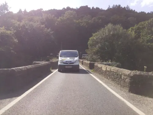
New Bridge
Bridge · 3.3 mi
Grade I listed bridge in Cornwall/Devon, England
Museums and landmarks7

Buckland Abbey
Museum · 2.5 mi
Grade I listed historic house museum in Devon, England, UK


Cotehele
Museum · 1.8 mi
Grade I listed historic house museum in Calstock, Cornwall, England, UK

Morwellham Quay
Museum · 1.6 mi
Historic river port in Devon, England


Parks, trails and playgrounds5

Tamar Valley AONB
Park · 1.9 mi
Area of outstanding natural beauty in England

Restaurants and cafes9

Gaucho BBQ
Restaurant · Barbecue
Mobile BBQ - Not a physical location Hire BBQ for an event here: http://gauchobbq.co.uk/private-hire/
Fore Street, Yelverton
closed




History
With a population of about 2,259 (2021 Census), the village lies in the Bere peninsula, between the rivers Tamar and Tavy. Its origins lie in the once thriving local mining industry, including silver and lead, and the market gardening sector. At one time, the mainline trains to London would stop at the village to pick up locally grown produce destined for the capital.
Bere Alston is about 12 km north of the centre of Plymouth as the crow flies, but the road trip requires either a long detour via Tavistock or else negotiating narrow lanes and a narrow bridge.
Trains still run to Bere Alston railway station on the picturesque Tamar Valley Line between Plymouth and Gunnislake, and trains reverse at this station. There has been discussion of making the station a junction once again by reopening the former 'main line' to Tavistock, the largest town in Devon currently without a railway station. Occasionally, the reopening of the line through to Okehampton and Exeter is suggested, since the current Plymouth to Exeter route is dependent on an extremely vulnerable route below the sea cliffs at Dawlish Warren.
Read more of the history
Bere Alston elected two members to the unreformed House of Commons. Only a few burgage holders were entitled to vote; but as most, if not all, of these holdings were held by a single individual for most of the time that Bere Alston was a parliamentary borough, elections were seldom contested (see rotten borough). Its MPs included Sir George Beaumont, 7th Baronet, Peter King, 1st Baron King and Josceline Percy. The borough was stripped of its franchise in the Reform Act 1832.
Once home to numerous pubs, the village now only has one public house, The Edgcumbe Hotel, on Fore Street, which at one time was also a jail and later a schoolhouse. Also on Fore Street is a Co-Op, Premier, Post-Office, and a Butchers. There is also a modern cafe, Hope Cottage, located next door to Bere Alston United Church.
From the History section of Bere Alston on Wikipedia, under CC BY-SA 4.0.
Where to stay1
Churches and places of worship7
Shopping2
Schools, colleges and libraries3
Healthcare1
Map of Bere Alston
36 places. The map loads OpenStreetMap tiles when you open it.
Getting there and nearby towns
Cornwall Airport Newquay (NQY) is the nearest airport with scheduled flights listed in OpenStreetMap, 35 miles away.
- Tavistock 5 mi northeast, about 8 min by car
- Saltash 5 mi south, about 8 min by car
- Plymouth 8 mi south, about 13 min by car
- Plymstock 10 mi southeast, about 15 min by car
- Princetown 10 mi northeast, about 16 min by car
- Pensilva 10 mi west, about 16 min by car
- Brixton 11 mi southeast, about 18 min by car
- Wembury 12 mi southeast, about 20 min by car
- Lifton 12 mi north, about 19 min by car
- Ivybridge 14 mi southeast, about 22 min by car
Drive times are estimates from straight-line distance, not routes.
Towns near Bere Alston


Keep exploring
Local news
Headlines from INDB.
Reviews, tips and questions
Loading what members have shared...
Sources and licences
- GeoNames (CC BY 4.0): population, coordinates, regions and time zone
- Mapillary (see each image): photos
- OpenStreetMap contributors (ODbL 1.0): places, airports, map data
- Wikidata (CC0 1.0): elevation, founding date, time zone, website, landmarks and historic places
- Wikimedia Commons (see each image): photos
- Wikipedia (CC BY-SA 4.0): overview and history text
Photo credits
- BereFerrersChurch, Lobsterthermidor at English Wikipedia, CC0
- St Andrew's Church and Cross, Buckland Monachorum, Nilfanion, CC BY-SA 3.0
- St Andrew's Church in Calstock, Nick Lansley, CC BY 2.0
- Calstock from train, Ben Harris, Public domain
- Jaguar XF Facelift, GaiusS, CC BY-SA 4.0
- Buckland Abbey tower, Nilfanion, CC BY-SA 3.0
- Cotehele, house from courtyard, Rwendland, CC BY-SA 3.0
- Waterwheel at Morwellham Quay, Penny Mayes, CC BY-SA 2.0
- Street-level photo, MapBM, CC BY-SA 4.0
- Street-level photo, southglos, CC BY-SA 4.0
- Street-level photo, MapBM, CC BY-SA 4.0
- Street-level photo, MapBM, CC BY-SA 4.0
- Street-level photo, WaggyDog, CC BY-SA 4.0
Page built November 10, 2026. Spotted a mistake? Tell us or suggest a place.