


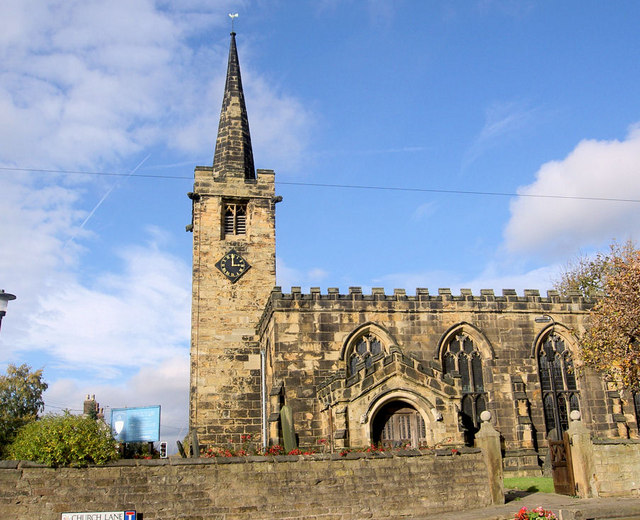
Why visit Birdwell
Townapedia lists 15 museums and landmarks, 11 parks and trails, 34 places to eat, 1 place to stay and 2 attractions in and around town.
Highlights include Elsecar Heritage Centre, Obelisk to Lady Mary Wortley Montagu, Locke Park and Penny Pie Park.
Weather in Birdwell
Forecast from MET Norway (CC BY 4.0). Full forecast
About Birdwell
Birdwell is a village in the Metropolitan Borough of Barnsley in South Yorkshire, England and is located approximately 3.5 miles (6 km) south of Barnsley, 10.5 miles (17 km) north-east of Sheffield. Birdwell currently falls within the Rockingham Ward of the Barnsley Metropolitan Council, although plans to add most of Birdwell to the Worsbrough Ward were proposed again in 2024.
From the Wikipedia article Birdwell, South Yorkshire (this version), under CC BY-SA 4.0.
Things to do2


Museums and landmarks15

Elsecar Heritage Centre
Museum · 2.8 mi
Living history museum in Elsecar, England

Obelisk to Lady Mary Wortley Montagu
Monument and historic site · 1.9 mi
Obelisk in Stainborough, Barnsley, South Yorkshire, England, UK

Wentworth Castle
Museum · 1.8 mi
Grade I listed historic house museum in Stainborough, Barnsley, South Yorkshire, England, UK




3 more on the map.
Parks, trails and playgrounds11


Penny Pie Park
Park · 2.9 mi
Park in Barnsley, South Yorkshire, England, United Kingdom



Restaurants and cafes34

22 more on the map.
History
Although Birdwell was a hamlet in the Worsbrough district, the origins of Birdwell date back to the time of the English Civil War, around 1642, when the name of the small settlement is thought to be first mentioned.
Birdwell is part of the Parish of Worsbrough St Mary's. The 11th century church is situated less than ½ mile away in nearby Worsbrough Village.
Birdwell was until 1974 part of the Worsbrough Urban District, in the West Riding of Yorkshire.
In the years following the Second World War, open cast mining took place on much of the land to the northern end of Birdwell, and in some areas the remains of the quarries can still be found. Much of the land was subsequently restored to agriculture, mainly pasture with a little low key arable production and since the 1970s was owned by a local farming company. A small pocket of woodland called Parkinson Spring survived the mining activity and whilst little is known of its history, the name 'spring' could infer it was coppiced for the production of spring wood. The predominantly ancient woodlands of Miller Hill and Wigfield Wood are thought to be remnants of the once extensive woodland of the Wortley Park estate, an area through which the M1 motorway was subsequently built.
Read more of the history
Hangmanstone Depot was the site of Allan Finlay's diesel engine export company Hartwood Exports, where a great number of UK buses and other commercial vehicles ended their lives.
Birdwell & Hoyland Common railway station, was a railway station on the South Yorkshire Railway's Blackburn Valley Line betwixt Westwood and Dovecliffe railway stations. Although named after nearby Hoyland Common and Birdwell, the station was built in Tankersley. The station was intended to serve Birdwell, Pilley and Hoyland Common, although the original chosen site was moved half a mile nearer towards Barnsley to serve the purposes of the Earl of Wharncliffe who was, at that time, sinking Wharncliffe Silkstone Colliery in nearby Tankersley. The station was opened in February 1855, the building having an ornate canopy over its entrance and containing a private waiting room for use by the Earl of Wharncliffe. The station was closed on 7 December 1953.
Nearby coal mines including Barrow Colliery and Rockingham Colliery.
From the History section of Birdwell, South Yorkshire on Wikipedia, under CC BY-SA 4.0.
More about Birdwell
Education
Birdwell has its own primary school(formerly Worsbrough Birdwell Primary) and private day-nursery called Chatterbox. Worsbrough St. Mary's Primary closed in 2007, it was situated on the northern edge of Birdwell, near to Worsbrough Village.
From the Wikipedia article Birdwell, South Yorkshire, under CC BY-SA 4.0.
Notable people from Birdwell
- John Cookefootballer, born 1942
- Harry RuddlesdinEnglish footballer (1876-1910)
- Albert HayhurstEnglish footballer (1905-1991)
- Jim Grummett, Sr.footballer (1918-1996)
- Michael CleggBritish biologist, museum curator, and tv presenter
Born in Birdwell, according to Wikidata (CC0). Each name links to its Wikipedia article.
Where to stay1
Churches and places of worship13
Shopping5
Gas and EV charging3
Schools, colleges and libraries8
Tankersley St Peter's CofE (Aided) Primary School
School · Anglican · 1.1 mi
Westwood New Road, Barnsley
Healthcare5
Map of Birdwell
97 places. The map loads OpenStreetMap tiles when you open it.
Getting there and nearby towns
Leeds Bradford Airport (LBA) is the nearest airport with scheduled flights listed in OpenStreetMap, 25 miles away.
- Hoyland Nether 2 mi southeast, about 2 min by car
- Barnsley 2 mi north, about 4 min by car
- Chapeltown 3 mi south, about 5 min by car
- Wombwell 3 mi east, about 6 min by car
- Silkstone 4 mi northwest, about 7 min by car
- Cudworth 5 mi northeast, about 8 min by car
- Stocksbridge 5 mi southwest, about 8 min by car
- Darton 5 mi north, about 9 min by car
- Wath upon Dearne 6 mi east, about 9 min by car
- Penistone 6 mi west, about 10 min by car
Drive times are estimates from straight-line distance, not routes.
Towns near Birdwell


Keep exploring
Local news
Headlines from INDB.
Reviews, tips and questions
Loading what members have shared...
Sources and licences
- GeoNames (CC BY 4.0): population, coordinates, regions and time zone
- Mapillary (see each image): photos
- OpenStreetMap contributors (ODbL 1.0): places, airports, map data
- Wikidata (CC0 1.0): elevation, founding date, time zone, website, landmarks and historic places
- Wikimedia Commons (see each image): photos
- Wikipedia (CC BY-SA 4.0): overview and history text
Photo credits
- Barn, Hay Green Lane, Birdwell, Neil Theasby, CC BY-SA 2.0
- Sun Monument, Wentworth Castle, habiloid, CC BY-SA 2.0
- Wentworth Castle02 2007-08-13, Klaus with K . Blue fringing removed by Digon3 13:34, 24 August 2007 (UTC), CC BY-SA 3.0
- LockePark 26042015, ChicXulub, CC BY-SA 4.0
- PennyPiePark 26042015, ChicXulub, CC BY-SA 4.0
- Worsbrough - Saint Mary's Church, Steve F, CC BY-SA 2.0
- Hoyland Lowe Stand 2014, Chemical Engineer, CC BY-SA 4.0
- Stainborough - Wentworth Castle Rotunda, Steve F, CC BY-SA 2.0
- St Peter, Tankersley, Chemical Engineer, CC BY-SA 3.0
- Our Lady and St James Church, Worsbrough, Brian Yarham, CC BY-SA 2.0 uk
- Queen Anne's Obelisk, Neil Theasby, CC BY-SA 2.0
- St Peter's Church, Hoyland 2014, Chemical Engineer, CC BY-SA 4.0
- Elsecar Heritage Centre Sentinel Elizabeth locomotive - November 2017, Neil Turner, CC BY-SA 2.0
- The Rotunda, Stainborough Park, Neil Theasby, CC BY-SA 2.0
- Street-level photo, cuttlebug, CC BY-SA 4.0
- Street-level photo, cuttlebug, CC BY-SA 4.0
- Street-level photo, cuttlebug, CC BY-SA 4.0
- Street-level photo, cuttlebug, CC BY-SA 4.0
- Street-level photo, cuttlebug, CC BY-SA 4.0
- Street-level photo, cuttlebug, CC BY-SA 4.0
- Street-level photo, cuttlebug, CC BY-SA 4.0


Page built November 10, 2026. Spotted a mistake? Tell us or suggest a place.