


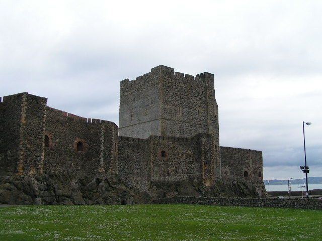


Carrickfergus, United Kingdom
Carrickfergus is a town of 29,208 people in Northern Ireland, United Kingdom.
Why visit Carrickfergus
Townapedia lists 15 museums and landmarks, 6 parks and trails, 44 places to eat, 4 places to stay and 2 attractions in and around town.
Highlights include Omniplex, Andrew Jackson Cottage and US Rangers Museum and Knockagh Monument.
Weather in Carrickfergus
Forecast from MET Norway (CC BY 4.0). Full forecast
About Carrickfergus
Carrickfergus (from Irish Carraig Fhearghais [ˌkaɾˠəc ˈaɾˠəgəʃ, ˌkaɾˠəɟ ˈaɾˠiːʃ], meaning "Fergus' rock") is a historic coastal town in County Antrim, Northern Ireland. It sits on the north shore of Belfast Lough, 11 miles (18 km) from Belfast. The town had a population of 28,141 at the 2021 census. It is County Antrim's oldest town and one of the oldest towns in Ireland as a whole.
From the Wikipedia article Carrickfergus (this version), under CC BY-SA 4.0.
Travel tips from other travellers: Carrickfergus on Wikivoyage (CC BY-SA 4.0).
Things to do2


Museums and landmarks15

Andrew Jackson Cottage and US Rangers Museum
Museum · 1.0 mi
Museum in County Antrim, Northern Ireland, United Kingdom, celebrating the ancestral home of US President Andrew Jackson

Knockagh Monument
Monument and historic site · 3.0 mi
Northern Ireland war monument
Andrew Jackson Cottage and US Rangers Centre
Monument and historic site · 1.0 mi



3 more on the map.
Parks, trails and playgrounds6




Restaurants and cafes44

Cafe Rose
Cafe · Regional · 0.5 mi
32 Bridewell Drive, Carrickfergus
Mo-Fr 10:30-14:30; We off; Sa 10:30-13:30

PaPa Browns Grill
Restaurant
Marine Highway, Carrickfergus
Mo-Th 09:00-21:00; Fr,Sa 09:00-21:30; Su 09:00-20:00



32 more on the map.
History
The town is said to take its name from Fergus Mór (Fergus the Great), the legendary king of Dál Riata. According to one tale, his ship ran aground on a rock by the shore, which became known as "Carraig Fhearghais" – the rock of Fergus.
As an urban settlement, Carrickfergus far pre-dates the capital city Belfast and was for a lengthy period both larger and more prominent than the nearby city. Belfast Lough itself was known as Carrickfergus Bay well into the 17th century. The historical walled town originally occupied an area of around 97,000 square metres, which now comprises the town centre, bordered by Albert Road to the west, the Marine Highway to the south, Shaftesbury Park to the north and Joymount Presbyterian Church grounds to the east. Segments of the town wall are still visible in various parts of the town and in various states of preservation. Archaeological excavations close to the walls' foundations have yielded many artefacts that have helped historians piece together a picture of the lives of the 12th and 13th century inhabitants.
Read more of the history
Carrickfergus became an inhabited town shortly after 1170, when Anglo-Norman knight John de Courcy invaded Ulster, established his headquarters in the area and built Carrickfergus Castle on the "rock of Fergus" in 1177. The castle, which is the most prominent landmark of Carrickfergus, is widely known as one of the best-preserved Norman castles in Ireland.
Sometime between 1203 and 1205, De Courcy was expelled from Ulster by Hugh de Lacy, as authorised by King John. De Lacy oversaw the final construction of the castle, which included the gatehouse, drum towers and outer ward. It was at this time that he established the nearby St Nicholas' Church. De Lacy was relieved of his command of the town in 1210, when King John himself arrived and placed the castle under royal authority. De Lacy eventually regained his title of Earl of Ulster in 1227, however the castle and its walled town were captured several more times following his death (in 1242). The forces of Edward de Bruce captured the town in 1315 and the castle in 1316 before his death in battle in 1318. The town was largely destroyed by the Scots in 1402.
The Battle of Carrickfergus, part of the Nine Years War, took place in and around the town in November 1597. It was fought between the crown forces of Queen Elizabeth I and the Scots clan of MacDonnell, and resulted in a defeat for the English. A contemporary Elizabethan illustration of Carrickfergus shows ten tower-houses, as well as terraces of single-storey houses, some detached cottages and 70 or more Irish beehive-type huts in the town.
Sir Arthur Chichester was appointed by the Earl of Essex to govern the castle and town in 1599 and was responsible for the plantation of English and Scottish peoples in the town, as well as the building of the town wall.
In 1642, during the Irish Confederate Wars the Presbytery of Carrickfergus, the first in Ireland, was set up by chaplains with the Covenanter Army in Ireland.
Nevertheless, the decaying castle withstood several days of siege by the forces of William of Orange in 1689, before surrendering on 28 August. William himself subsequently landed at Carrickfergus on 14 June 1690.
During the Seven Years' War, in February 1760, the whole town was briefly captured and held to ransom by French troops landed from Francois Thurot's naval squadron, after the defenders ran out of ammunition. In 1711 Carrickfergus was the scene of the last witchcraft trial in Ireland. Eight women were charged with bewitching a young girl, and were convicted, despite a strong indication from one of the judges that the jury should acquit. They were sentenced to a year in prison and four sessions in the pillory.
In April 1778, during the American War of Independence, John Paul Jones, in command of the American ship Ranger, attempted to capture a British Royal Navy sloop of war, HMS Drake, moored at Carrickfergus. Having failed, he returned a few days later and challenged Drake to a fight out in the North Channel which the Americans won decisively.
During the 1790s there was considerable support in the Carrickfergus area for the United Irishmen. On 14 October 1797 William Orr was hanged in the town following what was widely regarded as a show trial held in Carrickfergus Courthouse (now the Town Hall) and in 1798 United Irish founder Henry Joy McCracken was captured on the outskirts of the town while trying to escape to America.
In 1912 the people of Carrickfergus turned out in their thousands to watch as the RMS Titanic made its first ever journey up the lough from its construction dock in Belfast. The famous passenger liner was anchored overnight just off the coast of Carrickfergus, before continuing on its journey.
During World War II, Northern Ireland was an important military base for United States Naval and Air Operations and a training ground for American G.I.s. The First Battalions of the elite US Rangers were activated and based in Sunnylands Camp for their initial training. The US Rangers Centre in nearby Boneybefore pays homage to this period in history. It is rumoured that Italian and German POWs were held in the town, the Italians in a camp at Sullatober mill, and Germans at Sunnylands.
In the 1970s, the town became an important centre for the textile industry. An ICI man-made fibres factory was opened at Kilroot and was followed by the Rothman's cigarette factory. Courtaulds operated a large rayon works there until the 1980s.
In 1981, Kilroot power station opened and is the largest power station in Northern Ireland.
On 8 September 2007, Carrickfergus was the Northern Irish host for the Last Night at the Proms, featuring Alison Balsom, Alfie Boe, and Ulster conductor Kenneth Montgomery.
The British peerage title of Baron Carrickfergus, which had become extinct in 1883, was bestowed upon Prince William on his wedding day in 2011. He visited the town with Catherine, Princess of Wales in October 2022.
From the History section of Carrickfergus on Wikipedia, under CC BY-SA 4.0.
Notable people from Carrickfergus
 Eddie MagillNorthern Irish footballer and managerPhoto: Eskil Malmberg, Public domain
 Jimmy HillfootballerPhoto: Eskil Malmberg, Public domain
 Jackie WoodburneAustralian actressPhoto: 5 albert square, CC BY-SA 4.0
 John StewartNorthern Irish politician (born 1983)Photo: Northern Ireland Assembly, CC BY 4.0
 Daniel Cambridgerecipient of the Victoria CrossPhoto: Unknown author, Public domain
- Seán LesterIrish diplomat (1888-1959)
- Robert AdrainAmerican mathematician (1775-1843)
- Charlotte RiddellIrish novelist, editor
- Edward Holmesfield hockey player
- Billy McCulloughNorthern Irish footballer (1935–2026)
- Mary FortuneIrish-Australian detective writer
- Roy TaylorProfessor of Ultrafast Physics and Technology at Imperial College London
Born in Carrickfergus, according to Wikidata (CC0). Each name links to its Wikipedia article.
Where to stay4
Churches and places of worship18
Carrickfergus Elim Church
Church · Elim Pentecostal · 0.7 mi
Northland, Carrickfergus
Downshire Presbyterian Church
Church · Presbyterian · 1.0 mi
Victoria Road, Carrickfergus
Shopping11
Gas and EV charging6
Schools, colleges and libraries14
Healthcare5
Carrickfergus Health Centre
Clinic and pharmacy · 0.4 mi
Taylor's Avenue, Carrickfergus
Map of Carrickfergus
125 places. The map loads OpenStreetMap tiles when you open it.
Getting there and nearby towns
George Best Belfast City Airport (BHD) is the nearest airport with scheduled flights listed in OpenStreetMap, 7 miles away.
- Holywood 5 mi south, about 9 min by car
- Newtownabbey 6 mi southwest, about 9 min by car
- Dundonald 9 mi south, about 14 min by car
- Larne 9 mi north, about 15 min by car
- Belfast 10 mi southwest, about 15 min by car
- Newtownards 10 mi southeast, about 16 min by car
- Lisburn 16 mi southwest, about 26 min by car
- Downpatrick 27 mi south, about 43 min by car
- Portadown 33 mi southwest, about 52 min by car
- Cookstown 38 mi west, about 1 h by car
Drive times are estimates from straight-line distance, not routes.
Towns near Carrickfergus


Keep exploring
Local news
Headlines from INDB.
Reviews, tips and questions
Loading what members have shared...
Sources and licences
- GeoNames (CC BY 4.0): population, coordinates, regions and time zone
- OpenStreetMap contributors (ODbL 1.0): places, airports, map data
- Wikidata (CC0 1.0): elevation, founding date, time zone, website, landmarks and historic places
- Wikimedia Commons (see each image): photos
- Wikipedia (CC BY-SA 4.0): overview and history text
Photo credits
- Carrickfergus Town Hall - panoramio, Pastor Sam, CC BY 3.0
- The Hanging Gate Carrickfergus, Co Antrim. - panoramio, Pastor Sam, CC BY 3.0
- Carrickfergus Civic Centre and Museum - panoramio, Pastor Sam, CC BY 3.0
- Carrickfergus Castle2, Dave Dunford, CC BY-SA 2.0
- Andrew jackson diagonalview, ArchiveCarrickfergus, CC BY-SA 3.0
- Carickfergus Fire Engine - panoramio, Pastor Sam, CC BY 3.0
- Knockagh Monument above Greenisland, Carrickfergus - panoramio, Pastor Sam, CC BY 3.0
- Carrickfergus Castle 01, Donna from Belfast, Norn Iron, CC BY-SA 2.0

Page built November 10, 2026. Spotted a mistake? Tell us or suggest a place.