

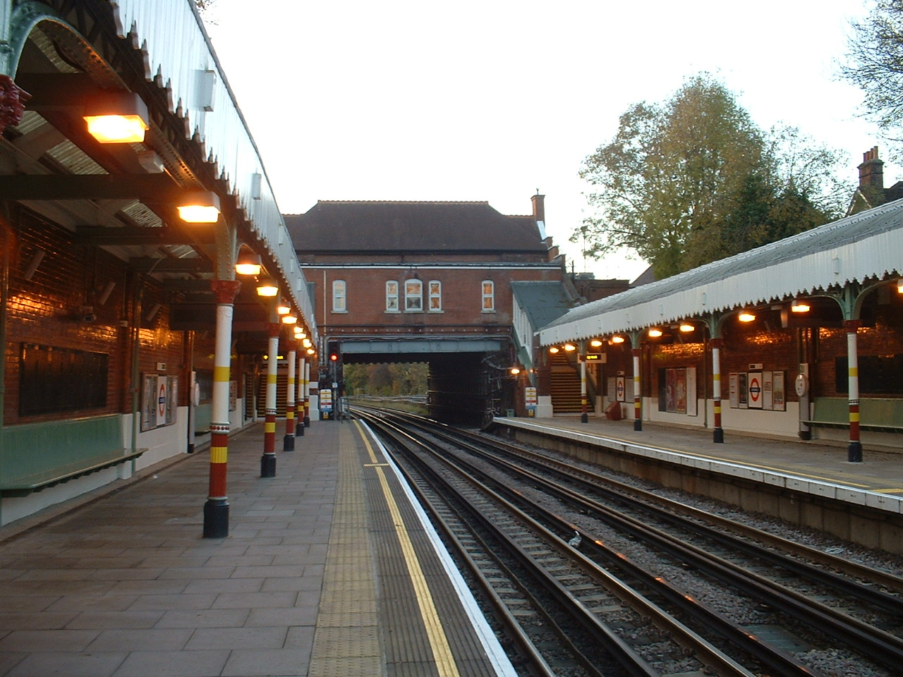


Chigwell, United Kingdom
Chigwell is a town of 12,250 people in England, United Kingdom.
Why visit Chigwell
Townapedia lists 21 museums and landmarks, 31 parks and trails, 175 places to eat, 3 places to stay and 2 attractions in and around town.
Highlights include Corbett Theatre, Anti-Air War Memorial, Buckhurst Hill War Memorial and Chigwell Row Wood.
Weather in Chigwell
Forecast from MET Norway (CC BY 4.0). Full forecast
About Chigwell
Chigwell is a town and civil parish in the Epping Forest District of Essex, England. It lies adjacent to the northern boundary of Greater London. It is on the Central line of the London Underground. At the 2021 census the parish had a population of 14,599 and the built up area had a population of 12,250.
From the Wikipedia article Chigwell (this version), under CC BY-SA 4.0.
Photos of Chigwell

Things to do2


Museums and landmarks21

Anti-Air War Memorial
Monument and historic site · 2.2 mi
Memorial in Woodford Green, London


Chingford War Memorial
Monument and historic site · 3.4 mi
War memorial in London

Dr Barnardo's Memorial
Monument and historic site · 2.4 mi
Memorial in London



Intone Stone
Monument and historic site · 1.0 mi
Flat stone on ground by roads through former RAF Chigwell base commemorating Operation Intone

9 more on the map.
Parks, trails and playgrounds31


Roding Valley Meadows
Park · 0.8 mi
Essex Wildlife Trust Nature reserve

Valentines Park
Park · 3.4 mi
Park in the London Borough of Redbridge, UK


19 more on the map.
Restaurants and cafes175


Deli Bites and Desserts
Restaurant · Indian · 2.3 mi
5b Claybury Broadway, Ilford
Mo closed; Tu-Fr 12:00-20:00; Sa 12:00-19:00; Su closed
Jilani Thai & Grill
Restaurant · Thai · 2.3 mi
12 Claybury Broadway, Ilford
Mo-Th 12:00-23:00; Fr-Su 15:00-23:00
Junglees
Restaurant · Chicken · 2.1 mi
27a High Street, Ilford
Mo-We 12:00-23:30; Th,Su 12:00-00:00; Fr-Sa 12:00-01:00
Shimla Merch Indian Takeaway
Restaurant · Indian · 0.9 mi
552-556 Limes Avenue, Chigwell
Mo-Su 17:00-22:30
Temple
Restaurant · Indian · 2.0 mi
Jubilee Parade, Woodford Green
Mo-Th 17:00-23:00; Fr,Sa 17:00-23:30; Su 13:00-22:00

Costa
Cafe · Coffee Shop · 2.0 mi
113 High Street, Ilford
Mo-Fr 06:30-19:00; Sa 07:00-19:00; Su 08:30-17:00
Costa
Cafe · Coffee Shop · 2.0 mi
5 The Broadway, Woodford Green
Mo-Fr 06:30-18:00; Sa 07:00-18:00; Su 08:00-17:00

The Chequers
Bar and pub · 2.2 mi
2 High Street, Ilford
Mo-Th 12:00-23:00; Fr-Sa 12:00-00:00; Su 12:00-23:00
163 more on the map.
History
The manor of Chigwell was held by Earl Harold under Edward the Confessor. From the 1550s it was the property of the Hicks Beach family.
The parish church of St Mary the Virgin dates back to the 12th century and is a Grade II* listed building.
Opposite the church is the Kings Head Hotel, a 17th century coaching inn.
According to P. H. Reaney's Place-Names of Essex the name means 'Cicca's well', Cicca being an Anglo-Saxon personal name. In medieval sources the name appears with a variety of spellings including "Cinghe uuella" and Chikewelle". Folk etymology has sought to derive the name from a lost "king's well", supposed to have been to the south-east of the parish near the border of what is now the London Borough of Redbridge. There were several medicinal springs in Chigwell Row documented by Miller Christy in his book History of the mineral waters and medicinal springs of the county of Essex, published in 1910. The 18th-century historian Nathaniel Salmon stated that the "-well" element in the name derives from Anglo-Saxon weald (wood).
The land registration map of Redbridge Council shows "Chig Well (site of)" as being located to the rear of the house located at 67 Brocket Way, Chigwell.
Read more of the history
Traditionally a rural farming community, but now largely suburban, Chigwell was mentioned in the Domesday Book of 1086. It is referred to by Charles Dickens in his novel Barnaby Rudge: A Tale of the Riots of 'Eighty; the Maypole Inn is based on the King's Head inn, though the name was taken from the Maypole public house in Chigwell Row. It is likely Dickens was aware of both hostelries, since he frequently visited Chigwell, which he described in a letter to John Forster as "the greatest place in the world ... Such a delicious old inn opposite the churchyard ... such beautiful forest scenery ... such an out of the way rural place..."[1].
From 1933 to 1958 there was an RAF presence at Roding Valley Meadows (near what is now the David Lloyd Leisure Centre). It served first to provide barrage balloon protection during the Second World War and was involved in the rollout of Britain's coastal nuclear early warning system during the Cold War. In 1953 it briefly housed the RAF contingent taking part in the Coronation celebrations. Some of the RAF Chigwell site is now part of the Local Nature Reserve, Roding Valley Meadows LNR.
From the History section of Chigwell on Wikipedia, under CC BY-SA 4.0.
More about Chigwell
Geography
The hamlet of Chigwell Row lies towards the east of Chigwell, near Lambourne; this part of the parish is well forested and mostly rural. Grange Hill is the area around the junction of Manor Road and Fencepiece Road/Hainault Road, extending as far as the boundary with Redbridge including the Limes Farm estate. Chigwell has a population of around 17,500 and is generally considered a wealthy area, characterised by large suburban houses, notably in Manor Road, Hainault Road and Chigwell High Road, which featured in the popular English situation comedy Birds of a Feather (although many of the outside locations used in that programme were not in Chigwell).
Arts and culture
Tottenham Hotspur Football Club had its training facilities in the area until May 2012, when it moved to a new facility in Enfield, northeast London. Leyton Orient Football Club also have a training ground in Chigwell, adjacent to Chigwell School's fields.
A David Lloyd Leisure Centre, situated off Roding Road by the M11 motorway, contains indoor and outdoor tennis courts, swimming pools and gymnasium. Also in the area are a Holmes Place Health Club, Topgolf playing Centre and Chigwell Golf Club. Chigwell Cricket Club is based at the Old Chigwellians Club in Roding Lane. Chigwell also plays host to the Old Loughtonians Hockey Club.
Ye Olde King's Head, which was operated as a pub until 2011, is said to be the Maypole Inn in Dickens' Barnaby Rudge. The building was subsequently sold to local resident Lord Sugar's property company Amsprop which now leases the Grade II* Listed building to the Sheesh Turkish restaurant.
Until their closure in 2002, Chigwell had night clubs, known collectively as the Epping Forest Country Club. There is a Local Nature Reserve at Roding Valley Meadows off Roding Lane which follows the River Roding up to Loughton.
Education
Schools in the area include Chigwell Primary Academy, Limes Farm Infants School & Nursery, Limes Farm Junior School, Guru Gobind Singh Khalsa College, West Hatch High School and Chigwell School, a private school, which was founded from a bequest by Samuel Harsnett, Archbishop of York, in 1629, among whose past pupils are William Penn, who later went on to found Pennsylvania, and actor Sir Ian Holm. The diarist John Aubrey recorded that it was at Chigwell School that Penn had a mystical vision, which influenced his later conversion to Quakerism. The original 17th-century schoolroom where Penn was taught still stands, and is now the school library.
From the Wikipedia article Chigwell, under CC BY-SA 4.0.
Notable people from Chigwell
 Mark WallingerBritish sculptor (born 1959)Photo: daisybush, CC BY 2.0
 Augustus Charles Newmanrecipient of the Victoria CrossPhoto: Unknown author Unknown author, Public domain
 Eliab HarveyBritish Royal Navy admiral, politician, and art collector (1758-1830)Photo: Lemuel Francis Abbott, Public domain
- Sally GunnellBritish former track and field athlete
- Vicki MichelleBritish actress
- Derek JohnsonBritish athlete
- Michael BlackEnglish footballer (born 1976)
- Tommy BlackEnglish footballer
- Honor SmithEnglish neurologist (1908-1995)
- John WatsonEnglish recipient of the Victoria Cross (1829–1919)
- Ann MichelleBritish actress
- Herbert DodkinsEnglish footballer (1929-2014)
Born in Chigwell, according to Wikidata (CC0). Each name links to its Wikipedia article.
Where to stay3
Churches and places of worship55
Shopping35
Gas and EV charging6
Schools, colleges and libraries62
Trinity Catholic High School (Upper Site)
School · Roman Catholic · 2.4 mi
Mornington Road, Woodford Green
Healthcare21
Map of Chigwell
250 places. The map loads OpenStreetMap tiles when you open it.
Getting there and nearby towns
London City Airport (LCY) is the nearest airport with scheduled flights listed in OpenStreetMap, 8 miles away.
- Woodford Green 2 mi west, about 4 min by car
- Snaresbrook 3 mi southwest, about 6 min by car
- Ilford 4 mi south, about 7 min by car
- Wanstead 4 mi southwest, about 6 min by car
- Goodmayes 4 mi south, about 7 min by car
- Walthamstow 5 mi southwest, about 7 min by car
- Barking 6 mi south, about 10 min by car
- Ponders End 6 mi west, about 9 min by car
- Leyton 6 mi southwest, about 9 min by car
- Dagenham 6 mi southeast, about 10 min by car
Drive times are estimates from straight-line distance, not routes.
Towns near Chigwell


Keep exploring
Local news
Headlines from INDB.
Reviews, tips and questions
Loading what members have shared...
Sources and licences
- GeoNames (CC BY 4.0): population, coordinates, regions and time zone
- Mapillary (see each image): photos
- OpenStreetMap contributors (ODbL 1.0): places, airports, map data
- Wikidata (CC0 1.0): elevation, founding date, time zone, website, landmarks and historic places
- Wikimedia Commons (see each image): photos
- Wikipedia (CC BY-SA 4.0): overview and history text
Photo credits
- Chigwell station (3015734780), Ewan Munro from London, UK, CC BY-SA 2.0
- Chigwell stn west, Sunil060902, CC BY-SA 3.0
- Pankhurst Memorial, 29 May 2011 (4), RolandR, CC BY-SA 3.0
- Chingford War Memorial 07, Edwardx, CC BY-SA 3.0
- Memorial to Dr Barnardo, Matt Brown, CC BY 2.0
- Chigwell Row Wood 4, Dudley Miles, CC BY-SA 3.0
- Ainslie Wood 1, Dudley Miles, CC BY-SA 3.0
- Hainault Lodge, Dudley Miles, CC BY-SA 3.0
- Havering Country Park 5, Dudley Miles, CC BY-SA 3.0
- Linder's Field 1, Dudley Miles, CC BY-SA 3.0
- Valentines Park, London Borough of Redbridge, IG1 (4163243333), Ewan Munro from London, UK, CC BY-SA 2.0
- Chingford United Reformed Church 05, Edwardx, CC BY-SA 3.0
- Christ Church, Wanstead, The wub, CC BY-SA 4.0
- St Mary the Virgin church, Wanstead - 2023-02-27, The wub, CC BY-SA 4.0
- St Peter-in-the-Forest - 02, The wub, CC BY-SA 4.0
- St Paul's Church, Woodford Bridge - 2022-07-31, The wub, CC BY-SA 4.0
- Braeside School from the air, Oak-Tree Group of Schools, CC BY-SA 4.0
- Trinity Catholic High School, Woodford Green, The wub, CC BY-SA 3.0
- Bancrofts School, User:JoannaScott, CC BY-SA 3.0
- Buckhurst Hill War Memorial, The wub, CC BY-SA 3.0
- Woodford Green War Memorial, The wub, CC BY-SA 4.0
- New Fairlop Oak, Fairlop, IG6 (5130967243), Ewan Munro from London, UK, CC BY-SA 2.0
- Ye Olde Kings Head (8062179758), Peter Broster, CC BY 2.0
- Valentines Mansion, Gardener's Cottage, The wub, CC BY-SA 4.0
- Christopher Cutchey and Arthur Bacot plaques at 19 York Hill Loughton IG10 1RL, Spudgun67, CC BY-SA 4.0
- Roding Valley Meadows 2, Dudley Miles, CC BY-SA 3.0
- Street-level photo, wasd42, CC BY-SA 4.0
- Street-level photo, rskedgell, CC BY-SA 4.0
- Street-level photo, gness, CC BY-SA 4.0
- Street-level photo, gness, CC BY-SA 4.0


Page built November 10, 2026. Spotted a mistake? Tell us or suggest a place.