
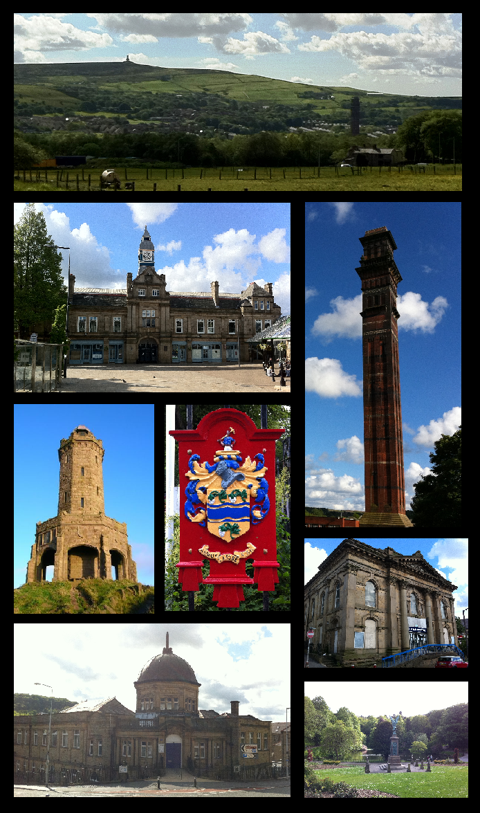


Why visit Darwen
Townapedia lists 12 museums and landmarks, 7 parks and trails, 30 places to eat, 4 places to stay and 6 attractions in and around town.
Highlights include Winter Hill, Blackburn Museum and Art Gallery and Jubilee Tower.
Weather in Darwen
Forecast from MET Norway (CC BY 4.0). Full forecast
About Darwen
Darwen is a market town and civil parish in the Blackburn with Darwen borough of Lancashire, England. The residents of the town are known as "Darreners". The town lies on the River Darwen, which flows from south to north and is seen in parks in the town centre. The A666 road passes through Darwen towards Blackburn to the north, Bolton to the south and Pendlebury, where it joins the A6, about 18 miles (29 km) north-west of Manchester.
From the Wikipedia article Darwen (this version), under CC BY-SA 4.0.
Photos of Darwen


Things to do6



Museums and landmarks12

Blackburn Museum and Art Gallery
Museum · 3.7 mi
Museum in Lancashire, England

Jubilee Tower
Monument and historic site · 1.1 mi
Tower in Darwen, Lancashire, United Kingdom, commemorating Queen Victoria's Diamond Jubilee

Mill engine
Monument and historic site · 0.5 mi
J & E Wood of Bolton horizontal cross compound mill engine. Corliss valves and rope drive.

Parks, trails and playgrounds7


Restaurants and cafes30

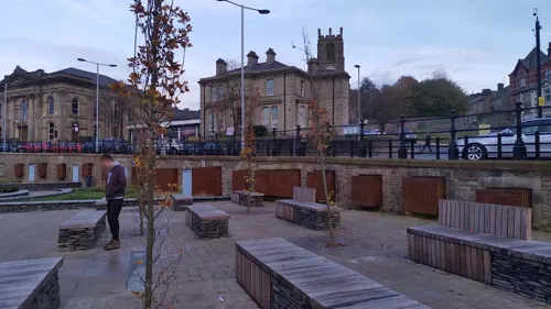
The Bridgewater
Bar and pub
9-10 Church Street, Darwen
Mo-We 09:00-23:00; Th 09:00-02:00; Fr,Sa 09:00-04:00; Su 10:00-00:00
Costa
Cafe · Coffee Shop · 1.1 mi
ExtraMSA Blackburn with Darwen Services, Darwen
24/7



18 more on the map.
History
The area around Darwen has been inhabited since the early Bronze Age and the remains of a round barrow from approximately 2000 BCE have been partially restored at the Ashleigh Barrow in Whitehall. The barrow had ten interments, nine of which were Collared Urn burials; as well as human remains, items found at the barrow included a bronze dagger some 7.5 inches (19 cm) in length, a flint thumb scraper, a sub-plano-convex knife and a clay bead. Copies of the Collared Urns may be seen at the Darwen Library.
The Romans once had a force in Lancashire and a Roman road is visible on the Ordnance Survey map of the area; medieval Darwen was tiny and little or nothing survives. One of the earliest remaining buildings is a farmhouse at Bury Fold, dated 1675. Whitehall Cottage is thought to be the oldest house in the town and was built mostly in the 17th and 18th centuries, but contains a chimney piece dated 1557.
Read more of the history
Like many towns in Lancashire, Darwen was a centre for textile manufacture during the Industrial Revolution. Samuel Crompton, inventor of the spinning mule, lived there for part of his life. The railway and the Leeds and Liverpool Canal arrived in the mid-19th century. The most important textile building in Darwen is India Mill, built by Eccles Shorrock & Company. The company was ruined, however, by the effects of the Lancashire Cotton Famine of the 1860s. Cotton manufacture was an important industry and the Darwen Weavers', Winders' and Warpers' Association had more than 8,000 members in the town by 1907.
In the early 1840s. Eccles Shorrock created a large mill lodge (industrial reservoir) in what is now the lower part of Bold Venture Park, by constructing a dam where Inverness Road now runs across the valley cut by Bold Venture Brook. In 1848, during a night of heavy thunder storms and torrential rain, water rushed down from the moors and the dam failed catastrophically. The water level dropped by 40 feet (12 m) almost instantly and a wall of water swept down into the town centre, causing considerable damage and drowning several people who slept in cellars under shops and houses in the Market Street area.
Much of the town was built between about 1850 and 1900. Many clues reflect this: placenames, date stones in terraces, the vernacular architecture of cellars, local stone, locally-made brick, pipework, tiles and leaded glass. It was one of the first places in the world to have steam trams.
Andrew Carnegie financed a Darwen Library; the town also had an art and technology college, and a grammar school. In 1931, Darwen was visited by Mahatma Gandhi, he had accepted the invitation from Corder Catchpool, Quaker manager of the Spring Vale Garden Village Ltd, to see the effects of India's boycott of cotton goods.
India Mill is now home to many companies, including Brookhouse (producers of aeroplane parts) and Capita Group, which runs TV licensing. Since the 1950s, the textile industry has strongly declined in the region, although many industrial buildings from the period survive, now used for other purposes. India Mill and its chimney were sold in a £12 million deal.
Crown Paints, formerly Walpamur Paints, the earliest British paint manufacturer, which named one of its paints Darwen Satin Finish
Crown Wallpaper manufactured wallpaper, Lincrusta and Anaglypta in the town. In 2004, Crown Wallcoverings, previously one of the biggest businesses in the town, closed with the loss of more than 200 jobs.
ICI Acrylics (now called Lucite International) was where acrylic glass (Perspex for windows and signage, and Sani-ware or Lucite used for the manufacture of baths and shower trays) was invented; it is still manufactured in two separate plants within the town
Spitfire canopies and (later) coloured polythene washing-up bowls were first made here. A heritage centre opened in 2016
From the History section of Darwen on Wikipedia, under CC BY-SA 4.0.
More about Darwen
Geography
Darwen is located amid the West Pennine Moors south of Blackburn; it stands within a valley with the river Darwen flowing at its base. The river passes through the town from south to north, subsequently joining the River Ribble, which flows into the Irish Sea between Lytham St Annes and Southport. The A666 road follows the valley through the town centre as part of its route from the Ribble Valley, north of Blackburn, to Bolton and the boundary between Pendlebury and Irlams o' th' Height in Salford. The town's weather conditions made it perfect for cotton weaving and, as a result, it became one of the largest mill towns in Lancashire.
The Guinness Book of Records records that Darwen had one of the largest flash floods in the United Kingdom, in 1848; 12 people died.
Arts and culture
The locals refer to themselves as Darreners; they are generally resistant to any attempts at submerging the identity of the town within Blackburn. A motorway service area at junction 4 of the M65 motorway lies within the town, and was originally named "Blackburn Services". Following local protests it was renamed "Blackburn with Darwen Services".
The Darwen School of Music (formerly Elite School of Music) is situated on Blackburn Road; it has a majority focus on popular music and is the parent school of the popular Begin2Sing workshop project.
Darwen Live (formerly Darwen Music Live) is a free two-day music festival held each year over the second bank holiday in May. The main stage is built outside the town hall, with other smaller stages are usually based around the town in pubs and bars. The festival has attracted artists such as Buzzcocks, China Crisis, Toyah, The Hoosiers, The Undertones and Paul Young, as well as being a showcase for local bands. It currently holds the title of the biggest free music festival in the UK by attendance, with its crowd of roughly 35-40,000 in 2024 even leading to the claim that it could be the largest in Europe.
Education
After the passing of the Education Act 1870, many schools were established to serve the ever-growing population (many were later demolished):
Darwen Aldridge Community Academy opened in September 2008 at the premises of the former Darwen Moorland High School on the outskirts of the town, which had closed in July 2008 to reopen as the academy after the summer holidays. All pupils from Darwen Moorland transferred to the academy. Pupils have subsequently moved down to the new site, into a state-of-the-art £49 million academy, with sixth form and modern facilities.
Darwen Vale High School was temporarily moved to the old Moorland site, whilst a new build was completed on the original site. The original school façade was incorporated into the new build and Darwen Vale was transferred back to the original site in 2012. However, the move had caused major issues with the management at the school, which led to the head leaving and a new head taking over in 2013. Later in 2013, Ofsted ruled that the school was failing and the government ordered the school's conversion to academy status, sponsored by the Aldridge Foundation, despite teaching staff and parents protesting governmental imposition on the school's management.
In September 2013, Darwen Aldridge Enterprise Studio opened and the school moved to its permanent home in 2014 in the renovated former Model Lodging House on Police Street.
From the Wikipedia article Darwen, under CC BY-SA 4.0.
Notable people from Darwen
 John CryerBritish politician (born 1964)Photo: David Woolfall, CC BY 3.0
 Alex DaviesEnglish cricketer (born 1994)Photo: Dave Morton, Public domain
 William BuryEnglish footballer (1865-1939)Photo: Neelands c, CC BY-SA 4.0
 Frederick C. SilvesterBritish organist (1901–1966)Photo: MargotBai, CC BY-SA 3.0
- Sam WadsworthEnglish footballer and manager (1896-1961)
- Justin AstleyBritish snooker player
- Tom BrindleEnglish footballer (1861-1905)
- Robert DuxburyEnglish footballer (1890-1962)
- Dick Burtonprofessional golfer (1907-1974)
- Joseph MarsdenEnglish footballer (1868-1897)
- Gary BrownEnglish footballer (born 1985)
- George WalshEnglish cricketer (1852-1904)
Born in Darwen, according to Wikidata (CC0). Each name links to its Wikipedia article.
Where to stay4
Churches and places of worship23
Shopping3
Gas and EV charging3
Schools, colleges and libraries19
Hoddlesden St Paul's Church of England Primary School
School · Anglican · 1.4 mi
Bayne Street, Darwen
Healthcare4
Map of Darwen
111 places. The map loads OpenStreetMap tiles when you open it.
Getting there and nearby towns
Warton Aerodrome (WRT) is the nearest airport with scheduled flights listed in OpenStreetMap, 17 miles away.
- Blackburn 4 mi north, about 6 min by car
- Haslingden 6 mi east, about 9 min by car
- Great Harwood 6 mi north, about 10 min by car
- Ramsbottom 7 mi southeast, about 11 min by car
- Rawtenstall 7 mi east, about 12 min by car
- Bolton 8 mi south, about 13 min by car
- Horwich 8 mi southwest, about 12 min by car
- Clayton-le-Woods 8 mi west, about 13 min by car
- Leyland 9 mi west, about 15 min by car
- Preston 11 mi northwest, about 17 min by car
Drive times are estimates from straight-line distance, not routes.
Towns near Darwen


Keep exploring
Local news
Headlines from INDB.
Reviews, tips and questions
Loading what members have shared...
Sources and licences
- GeoNames (CC BY 4.0): population, coordinates, regions and time zone
- Mapillary (see each image): photos
- OpenStreetMap contributors (ODbL 1.0): places, airports, map data
- Wikidata (CC0 1.0): elevation, founding date, time zone, website, landmarks and historic places
- Wikimedia Commons (see each image): photos
- Wikipedia (CC BY-SA 4.0): overview and history text
Photo credits
- Darwen, Oliver241088, CC BY-SA 3.0
- Darwen railway station Dec 2014 - Northbound platform, The wub, CC BY-SA 4.0
- 150002 at Darwen, Quackdave, CC0
- Darwen railway station Dec 2014 - looking North, The wub, CC BY-SA 4.0
- Darwen railway station Dec 2014 - ticket machine, The wub, CC BY-SA 4.0
- Benchmark at 6 Kay Street, Darwen, Ray Hutchings, CC BY-SA 4.0
- Darwen Library, Oliver241088, CC BY-SA 3.0
- Front of Blackburn Museum and Art Gallery, Museumania, Public domain
- Holy Trinity Church, Blackburn, Rebecca Moon, CC BY-SA 2.0
- Immanuel Church, Feniscowles, Chris Shaw, CC BY-SA 2.0
- St Barnabas' Church, Darwen, Alexander P Kapp, CC BY-SA 2.0
- St John's Church Turncroft001, Unknown author Unknown author, Public domain
- Jubilee Tower, north façade with entrance, Grzegorz Gniady, CC BY-SA 4.0
- DarwenAcademy1185, Darwenacademy, CC BY-SA 4.0
- Winter Hill From Blackrod, Paypwip, CC BY-SA 3.0
- The Old Chapel pub, Darwen, The wub, CC BY-SA 4.0
- B54737, Ray Hutchings, CC BY-SA 4.0
- B54740, Ray Hutchings, CC BY-SA 4.0
- Street-level photo, emr, CC BY-SA 4.0
- Street-level photo, tonys999, CC BY-SA 4.0
- Street-level photo, tonys999, CC BY-SA 4.0
- Street-level photo, tonys999, CC BY-SA 4.0
- Street-level photo, emr, CC BY-SA 4.0
- Street-level photo, emr, CC BY-SA 4.0
- Street-level photo, tonys999, CC BY-SA 4.0


Page built November 10, 2026. Spotted a mistake? Tell us or suggest a place.