


Why visit Edgmond
Townapedia lists 2 museums and landmarks, 2 parks and trails, 25 places to eat and 1 attraction in and around town.
Highlights include Sutherland Monument, Butter Cross and Chetwynd Deer Park.
Weather in Edgmond
Forecast from MET Norway (CC BY 4.0). Full forecast
About Edgmond
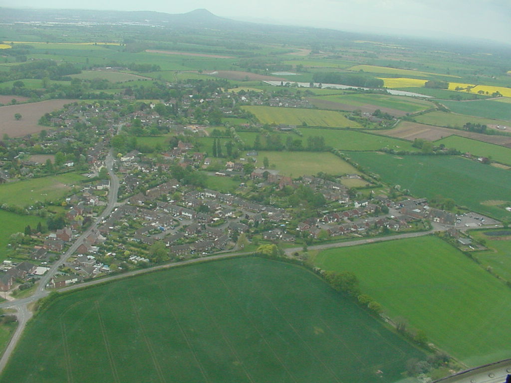
Edgmond is a village and civil parish in the borough of Telford and Wrekin and ceremonial county of Shropshire, England. The population of the parish at the 2011 Census was 2,062. It lies 1 mile (1.6 kilometres) north-west of the town of Newport.
From the Wikipedia article Edgmond (this version), under CC BY-SA 4.0.
Things to do1

Museums and landmarks2

Sutherland Monument
Monument and historic site · 2.5 mi
Monument in Lilleshall and Donnington, Telford and Wrekin, Shropshire, England, UK

Parks, trails and playgrounds2

Restaurants and cafes25

Dragon Soul Cafe
Cafe · 1.2 mi
Forton Road, Newport
Mo-Th 10:00-17:00; Fr,Sa 10:00-22:00; Su 10:00-16:00

13 more on the map.
More about Edgmond
Education
The village has a Church of England primary school, called St.Peter's.
Harper Adams University is in Edgmond. The University has accommodation in the village, where many international students stay. The main subjects taught at the college are related to the food chain and much research is done there. Here on 10 January 1982 the English lowest temperature weather record was broken (and is kept to this day): −26.1 °C (−15.0 °F).
From the Wikipedia article Edgmond, under CC BY-SA 4.0.
Churches and places of worship10
St Peter and St Paul's Roman Catholic Church
Church · Roman Catholic · 1.1 mi
Shopping1
Gas and EV charging1
Schools, colleges and libraries10
St Peter's Church of England Controlled Primary School and Nursery
School · Anglican
Stackyard Lane, Newport
Healthcare1
Map of Edgmond
53 places. The map loads OpenStreetMap tiles when you open it.
Getting there and nearby towns
Birmingham Airport (BHX) is the nearest airport with scheduled flights listed in OpenStreetMap, 35 miles away.
- Newport 1 mi east, about 2 min by car
- Hadley 6 mi southwest, about 10 min by car
- Telford 7 mi south, about 11 min by car
- Wellington 7 mi southwest, about 11 min by car
- Market Drayton 10 mi north, about 16 min by car
- Ironbridge 11 mi south, about 17 min by car
- Stafford 12 mi east, about 20 min by car
- Codsall 13 mi southeast, about 21 min by car
- Stone 14 mi northeast, about 23 min by car
- Shrewsbury 15 mi west, about 24 min by car
Drive times are estimates from straight-line distance, not routes.
Towns near Edgmond


Keep exploring
Local news
Headlines from INDB.
Reviews, tips and questions
Loading what members have shared...
Sources and licences
- GeoNames (CC BY 4.0): population, coordinates, regions and time zone
- Mapillary (see each image): photos
- OpenStreetMap contributors (ODbL 1.0): places, airports, map data
- Wikidata (CC0 1.0): elevation, founding date, time zone, website, landmarks and historic places
- Wikimedia Commons (see each image): photos
- Wikipedia (CC BY-SA 4.0): overview and history text
Photo credits
- Aa edgmond from heli 20070506, Anthony Appleyard at English Wikipedia, CC BY-SA 3.0
- Sunnyside, Edgmond, Richard Law, CC BY-SA 2.0
- Sutherland Monument Lilleshall Panorama, Mariegriffiths, CC BY-SA 4.0
- Newportstpeterschurc, Novacool88 ( talk ), Public domain
- Newport girls high, Bnustudent, Public domain
- The Puleston Cross, Newport, Shropshire, DeVerdon, CC BY-SA 4.0
- Street-level photo, trigpoint, CC BY-SA 4.0
- Street-level photo, trigpoint, CC BY-SA 4.0
- Street-level photo, trigpoint, CC BY-SA 4.0
- Street-level photo, trigpoint, CC BY-SA 4.0
- Street-level photo, trigpoint, CC BY-SA 4.0
- Street-level photo, gness, CC BY-SA 4.0
- Street-level photo, trigpoint, CC BY-SA 4.0
- Street-level photo, trigpoint, CC BY-SA 4.0
- Street-level photo, trigpoint, CC BY-SA 4.0
- Street-level photo, trigpoint, CC BY-SA 4.0
- Street-level photo, trigpoint, CC BY-SA 4.0
- Street-level photo, trigpoint, CC BY-SA 4.0
- Street-level photo, trigpoint, CC BY-SA 4.0
- Street-level photo, gness, CC BY-SA 4.0
- Street-level photo, trigpoint, CC BY-SA 4.0
- Street-level photo, gness, CC BY-SA 4.0
- Street-level photo, gness, CC BY-SA 4.0
- Street-level photo, trigpoint, CC BY-SA 4.0
- Street-level photo, trigpoint, CC BY-SA 4.0
- Street-level photo, trigpoint, CC BY-SA 4.0
- Street-level photo, trigpoint, CC BY-SA 4.0
- Street-level photo, trigpoint, CC BY-SA 4.0
Page built November 10, 2026. Spotted a mistake? Tell us or suggest a place.