


Gravesend, United Kingdom
Gravesend is a town of 54,263 people in England, United Kingdom.
Why visit Gravesend
Townapedia lists 80 museums and landmarks, 91 parks and trails, 144 places to eat, 21 places to stay and 26 attractions in and around town.
Highlights include Showcase Bluewater, Medway Viaducts, Shornemead Fort and Coalhouse Fort.
Weather in Gravesend
Forecast from MET Norway (CC BY 4.0). Full forecast
About Gravesend
Gravesend is a town in northwest Kent, England, situated 21 miles (35 km) east-southeast of Charing Cross (central London) on the south bank of the River Thames, opposite Tilbury in Essex. Located in the Diocese of Rochester, it is the administrative centre of the borough of Gravesham. Gravesend marks the eastern limit of the Greater London Built-up Area, as defined by the UK Office for National Statistics. It had a population of 58,102 in 2021.
From the Wikipedia article Gravesend (this version), under CC BY-SA 4.0.
Travel tips from other travellers: Gravesend on Wikivoyage (CC BY-SA 4.0).
Things to do26


Orchard Theatre
Cinema and theater · 6.6 mi
Theatre in Dartford, Kent, England

Queen Elizabeth II Bridge
Bridge · 5.1 mi
Bridge across the River Thames in south east England

Rochester Bridge
Bridge · 6.6 mi
Bridge in Rochester, Kent, England, UK

State Cinema
Cinema and theater · 3.2 mi
Former cinema and theatre in Grays, England

Woodville Halls Theatre
Cinema and theater
Theatre in Gravesend, England

14 more on the map.
Museums and landmarks80

Shornemead Fort
Monument and historic site · 2.7 mi
Fort in Shorne, Kent, England, UK

Coalhouse Fort
Monument and historic site · 3.1 mi
May-Sep Su[4] 11:00-17:00

Dartford Library
Museum · 6.6 mi
Public library and museum in Dartford, Kent, England, UK

Guildhall Museum, Rochester
Museum · 6.7 mi
Grade I listed local museum in Rochester, Kent, England, United Kingdom


Mucking excavation
Monument and historic site · 4.4 mi
Archaeological site in Essex, England

Restoration House
Museum · 6.9 mi
Historic house and museum in Rochester, Kent, England, United Kingdom

Temple Manor
Museum · 6.2 mi
Grade I listed historic house museum in Medway, United Kingdom

Thurrock Museum
Museum · 3.3 mi
Orsett Road, Grays
Mo-Th 09:00-19:00; Tu-We,Fr 09:00-17:00; Sa 09:00-13:00; Su,PH off

68 more on the map.
Parks, trails and playgrounds91



Shorne Woods Country Park
Park · 3.2 mi
Park in United Kingdom
Brewers Road
Mo-Su 09:00-dusk; Dec 25 off
Northfleet Urban Country Park
Park · 1.4 mi
59 Vale Road, Gravesend
24/7
Chafford Gorges Nature Park
Park · 4.5 mi
Essex Wildlife Trust Nature reserve

79 more on the map.
Restaurants and cafes144
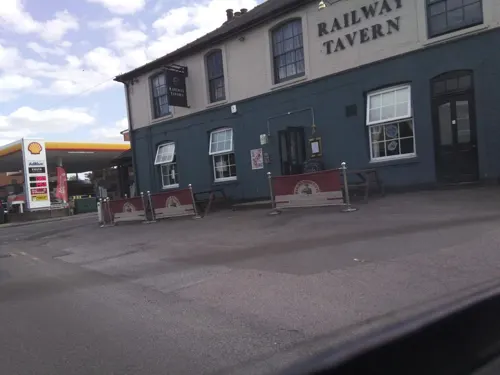
Railway Tavern
Bar and pub · British · 4.3 mi
2 Station Road, Longfield
Mo,Tu,Su 12:00-21:00; We,Th 12:00-22:30; Fr,Sa 12:00-23:30
Alto Gusto
Restaurant · Italian
32 Windmill Street, Gravesend
Mo-Th 11:00-22:00; Fr 11:00-00:00; Sa 12:00-22:00

Nando's
Restaurant · Chicken, Portuguese · 4.9 mi
West Thurrock Way, Grays
Mo 11:30-18:00; Tu-Sa 11:30-21:00; Su 11:30-17:00

PizzaExpress
Restaurant · Pizza · 4.3 mi
The Plaza, Greenhithe
Mo-Th 11:30-21:30; Fr-Sa 11:30-23:00; Su 11:30-21:00
Bangkok Mami
Restaurant · Thai
156 Parrock Street, Gravesend
Mo-Th 16:30-22:30; Fr,Sa 12:00-14:00,16:30-23:00; Su 13:00-22:30
132 more on the map.
History
Stone Age implements have been found in the locality since the 1900s, as has evidence of an Iron Age settlement at nearby Springhead. Extensive Roman remains have been found at nearby Vagniacae, and Gravesend lies immediately to the north of the Roman road connecting London with the Kent coast – now called Watling Street. Domesday Book recorded mills, hythes, and fisheries here.
Milton Chantry is Gravesend's oldest surviving building and dates from the early 14th century. It was refounded as a chapel in 1320/21 on the original site of a former leper hospital founded in 1189. It is a Grade II* listed building.
Gravesend has one of the oldest surviving markets in the country. Its earliest charter dates from 1268, with town status being granted to the two parishes of Gravesend and Milton by King Henry III in its Charter of Incorporation of that year. The first mayor of Gravesend was elected in 1268 but the first town hall was not built until 1573. The current Gravesend Town Hall was completed in 1764: although it ceased to operate as a seat of government in 1968 when the new Gravesham Civic Centre was opened, it remained in use as a magistrates' court until 2000. It now operates as a venue for weddings and civil partnership ceremonies.
In 1380, during the Hundred Years' War, Gravesend was raided by a French fleet.
Read more of the history
In 1401, a further royal charter was granted, allowing the men of the town to operate boats between London and the town; these became known as the "Long Ferry". It became the preferred form of passage, because of the perils of road travel (see below).
On Gravesend's river front are the remains of a device fort built by command of King Henry VIII in 1543.
In March 1617, John Rolfe and his Native American wife Rebecca (Pocahontas), with their two-year-old son, Thomas, boarded a ship in London bound for the Commonwealth of Virginia; the ship had only sailed as far as Gravesend before Rebecca fell ill, and she died shortly after she was taken ashore. It is not known what caused her death. Her funeral and interment took place on 21 March 1617 at the parish church of St George, Gravesend. The site of her grave was underneath the church's chancel, though since the previous church was destroyed by fire in 1727 her exact resting place is unknown. Thomas Rolfe survived, but was placed under the supervision of Sir Lewis Stukley at Plymouth, before being sent to his uncle, Henry Rolfe whilst John Rolfe and his late wife's assistant Tomocomo reached America under the captaincy of Sir Samuel Argall's ship. Pocahontas (real name: Matoaka) is an important figure in both American and British history.
At Fort Gardens is the New Tavern Fort, built during the 1780s and extensively rebuilt by Major-General Charles Gordon between 1865 and 1879; it is now the Chantry Heritage Centre, under the care of Gravesend Local History Society. The fort is a scheduled monument.
Journeys by road to Gravesend were historically quite hazardous, since the main London-Dover road crossed Blackheath, notorious for its highwaymen. Stagecoaches from London to Canterbury, Dover and Faversham used Gravesend as one of their "stages" as did those coming north from Tonbridge. In 1840 there were 17 coaches picking up and setting down passengers and changing horses each way per day. There were two coaching inns on what is now Old Road East: the Prince of Orange and the Lord Nelson. Post coaches had been plying the route for at least two centuries: Samuel Pepys records having stopped off at Gravesend in 1650 en route to the Royal Dockyards at Chatham.
A permanent military presence was established in the town when Milton Barracks opened in 1862.
Although much of the town's economy continued to be connected with maritime trade, since the 19th century other major employers have been the cement and paper industries.
From 1932 to 1956, an airport was located to the east of the town. On Sunday 5 February 1939, Alex Henshaw commenced his record-breaking flight to Cape Town and back from here. He completed the flight in 39 hours 36 minutes over the next four days; his record still stands. Originally a civilian airfield, during World War II it became a fighter station, RAF Gravesend, and so Gravesend was heavily bombed by the Luftwaffe. In 1956 the site was taken over by Gravesend Borough Council; a large housing estate, known as Riverview Park, was built on its site.
From the History section of Gravesend on Wikipedia, under CC BY-SA 4.0.
More about Gravesend
Geography
Gravesend is located at a point where the higher land, the lowest point of the dip slope of the North Downs, reaches the Thames. To the east are the low-lying Shorne Marshes; to the west lie Northfleet and the Swanscombe Marshes. The settlement developed in this location due to its suitability as a landing place, sheltered by the prominent height of what is now known as Windmill Hill (see Landmarks below). Although the hill remains a dominant feature, Gravesend's highest point is actually further inland at Marling Cross, adjacent to the A2.
In 1817, Gravesend, Kent, was described as a market town and the first port on the River Thames, containing 536 houses and 31,119 inhabitants. From these origins as a landing place and shipping port, Gravesend gradually extended southwards and eastwards. Better-off London residents began visiting the town during the summer months, initially by boat and later via railway. More extensive development followed after World War I, with further expansion after World War II, when many of the surrounding housing estates were constructed, some with the assistance of German prisoners of war.
Arts and culture
The Gravesend Historical Society meets regularly and produces a biannual magazine on its activities.
Charles Dickens lived at Gad's Hill Place, 2 miles (3.2 km) east of Gravesend and specifically mentions the town and its environs in at least three of his novels. In David Copperfield Mr. Peggotty, Ham and the Micawbers say their goodbyes and sail away from Gravesend to begin a new life in Australia. In Great Expectations, Pip, with accomplices, rows Magwitch from London downriver in expectation of waylaying a regular steamer (whilst under way in the Lower Hope, off Gravesend) bound for Hamburg. At St James' Church, in Cooling, Pip finds Magwitch hidden among the graves. Gravesend also appears in The Pickwick Papers by Charles Dickens.
In the 1902 novel Heart of Darkness by Joseph Conrad, Charles Marlow's ship, anchored off Gravesend, is the setting where he tells his tale.
The 1952 film "The Long Memory" starring John Mills was filmed in and around Gravesend.
The War Game was a 1965 BBC television drama-documentary film depicting a nuclear war that was initially banned, and not broadcast until July 1985. The film was shot in Gravesend and in the other Kent towns of Tonbridge, Chatham and Dover, with a cast which was almost entirely made up of non-actors.
Education
Gravesend many schools include Northfleet School for Girls; Northfleet Technology College (Northfleet School for Boys, on the former sites of Northfleet Secondary School for Boys and Gravesend Technical High School for Boys); Mayfield Grammar School (formerly Gravesend Grammar School for Girls); St John's Catholic Comprehensive School; Thamesview School and St George's Church of England School. Gravesend also hosts Gravesend Grammar School, a, consistently high-achieving grammar school and sixth form where 50% of students gained a Grade 7 (Grade A equivalent) or above in 2025. There are also primary age schools such as Whitehill Primary School, special schools and several independent schools, such as Bronte School and St Joseph's. Finally, the town is also host to an Adult Education Centre.
From the Wikipedia article Gravesend, under CC BY-SA 4.0.
Notable people from Gravesend
 Gemma ArtertonBritish actressPhoto: Donna Sydee, CC BY-SA 4.0
 Edwin ArnoldEnglish poet and journalist (1832–1904)Photo: Stereoscopic Co., Public domain
 George E. P. BoxBritish statistician (1919–2013)Photo: DavidMCEddy at en.wikipedia, CC BY-SA 3.0
 John MacGregorBritish canoeist (1825-1892)Photo: Window & Grove, Public domain
 Georgia-Mae FentonBritish artistic gymnastPhoto: Sandro Halank , Wikimedia Commons, CC BY-SA 4.0
 Katharine HamnettBritish fashion designer (born 1947)Photo: Open Media Ltd, CC BY-SA 3.0
 Annabelle ChukwuCanadian association football playerPhoto: Bryan Berlin, CC BY-SA 4.0
 Richard RycroftEnglish actor and comedian (born 1960)Photo: Gemma Poole from Hitchin, CC BY-SA 2.0
- Derek BartonEnglish organic chemist (1918–1998)
- Paul RitterEnglish actor (1966–2021)
- Richard HughesBritish musician
- Thom GunnEnglish poet (1929-2004)
Born in Gravesend, according to Wikidata (CC0). Each name links to its Wikipedia article.
Where to stay21
Churches and places of worship52
St Mary's Church
Church · Anglican · 2.7 mi
Linford Road, Chadwell St Mary
Church of Saint Catherine
Church · Anglican · 3.1 mi
Princess Margaret Road, East Tilbury
Shopping72
Gas and EV charging21
Schools, colleges and libraries39
Langafel Church of England Voluntary Controlled Primary School
School · Anglican · 4.0 mi
Main Road, Longfield
Saint George's Church of England School (Secondary Phase)
School · Anglican · 1.1 mi
Meadow Road, Gravesend
Healthcare36
Map of Gravesend
250 places. The map loads OpenStreetMap tiles when you open it.
Getting there and nearby towns
Rochester Airport (RCS) is the nearest airport with scheduled flights listed in OpenStreetMap, 9 miles away.
- Tilbury 2 mi north, about 2 min by car
- Swanscombe 3 mi west, about 4 min by car
- Grays 3 mi northwest, about 5 min by car
- Longfield 4 mi southwest, about 7 min by car
- Hartley 5 mi southwest, about 8 min by car
- South Ockendon 6 mi northwest, about 10 min by car
- Stanford-le-Hope 6 mi northeast, about 10 min by car
- Rochester 7 mi southeast, about 11 min by car
- Gillingham 8 mi southeast, about 14 min by car
- Bexley 10 mi west, about 15 min by car
Drive times are estimates from straight-line distance, not routes.
Towns near Gravesend


Keep exploring
Local news
Headlines from INDB.
Reviews, tips and questions
Loading what members have shared...
Sources and licences
- GeoNames (CC BY 4.0): population, coordinates, regions and time zone
- Mapillary (see each image): photos
- OpenStreetMap contributors (ODbL 1.0): places, airports, map data
- Wikidata (CC0 1.0): elevation, founding date, time zone, website, landmarks and historic places
- Wikimedia Commons (see each image): photos
- Wikipedia (CC BY-SA 4.0): overview and history text
Photo credits
- MedwayM2Bridge5567, Clem Rutter, Rochester Kent, CC BY-SA 3.0
- DartfordOrchard4885, Clem Rutter, Rochester Kent, CC BY-SA 3.0
- Rochester Bridge from Rochester Castle Gardens, Prioryman, CC BY-SA 4.0
- Charlestons downstairs bar2, Peter Hammond, Public domain
- Shornemead Fort exterior view 2, Prioryman, CC BY-SA 4.0
- DartfordMuseumLibrary3791, Clem Rutter, Rochester Kent, CC BY-SA 3.0
- GuildhallRochester, ClemRutter at en.wikipedia, CC BY 2.5
- Mucking fittingsDSCF9566, Johnbod, CC BY-SA 4.0
- Restoration House, Rochester, SilkTork, CC BY-SA 3.0
- Strood TempleManor Left, Clem Rutter, Rochester, Kent., CC BY 2.5
- Neale(1818) p1.298 - Belhus, Essex, John Preston Neale, Public domain
- FrindsburyChurchGreenChatZoom, Clem Rutter, Rochester, Kent., CC BY 2.5
- St Mary's Church, Corringham, Essex, Rjm at sleepers ( talk ), CC BY-SA 3.0
- StonebridgeRdEnd, Friejose at English Wikipedia, CC BY-SA 3.0
- GravesendGurdwara3436, Clem Rutter, Rochester Kent, CC BY-SA 3.0
- St Georges Church, Agw19666, CC BY-SA 3.0
- Milton Chantry, Agw19666, CC BY-SA 3.0
- Gravesend library (33129523660), JuliaC2006 from Rochester, UK, CC BY 2.0
- Bluewater3754, Clem Rutter, Rochester Kent, CC BY-SA 3.0
- Elephants at Castle Hill Park, Ebbsfleet (2), Sunolafjagtenben-hur, CC0
- Aerial shot of bluewater, kent, Wikipedian395, CC BY 4.0
- Queen Elizabeth II bridge Penny Mayes, Penny Mayes, CC BY-SA 2.0
- Coalhouse Fort 2, Oxymoron, CC BY-SA 2.0
- Street-level photo, southglos, CC BY-SA 4.0
- Street-level photo, abeorch, CC BY-SA 4.0
- Street-level photo, abeorch, CC BY-SA 4.0
- Street-level photo, caranteth, CC BY-SA 4.0
- Street-level photo, tallguy, CC BY-SA 4.0
- Street-level photo, tallguy, CC BY-SA 4.0
- Street-level photo, wasd42, CC BY-SA 4.0
- Street-level photo, tallguy, CC BY-SA 4.0
- Street-level photo, essexboy, CC BY-SA 4.0
- Street-level photo, Semir_Mapillary, CC BY-SA 4.0


Page built November 10, 2026. Spotted a mistake? Tell us or suggest a place.