



Great Bedwyn, United Kingdom
Great Bedwyn is a town of 1,175 people in England, United Kingdom.
Why visit Great Bedwyn
Townapedia lists 1 museum or landmark, 3 places to eat and 2 attractions in and around town.
Highlights include Oakhill Down Lock and Bridge, Bedwyn Church Lock and Crofton Pumping Station.
Weather in Great Bedwyn
Forecast from MET Norway (CC BY 4.0). Full forecast
About Great Bedwyn
Great Bedwyn is a village and civil parish in east Wiltshire, England. The village is on the River Dun about 4.5 miles (7.2 km) southwest of Hungerford, 14 miles (23 km) southeast of Swindon and 6 miles (9.7 km) southeast of Marlborough.
From the Wikipedia article Great Bedwyn (this version), under CC BY-SA 4.0.
Things to do2

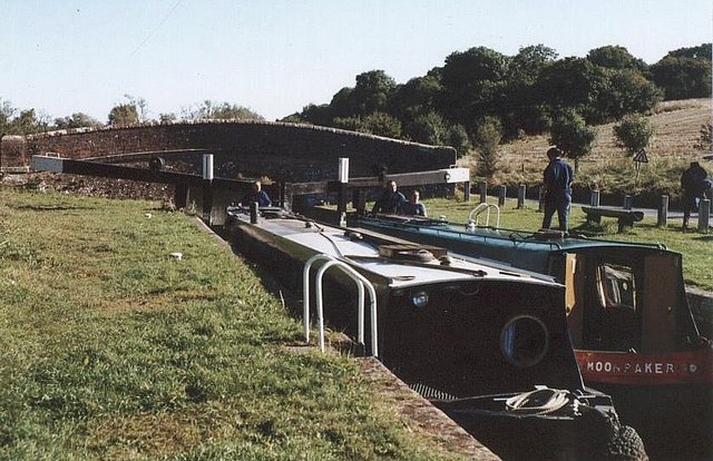
Oakhill Down Lock and Bridge
Bridge · 2.1 mi
Lock and bridge on the Kennet and Avon Canal in Froxfield, Wiltshire, England, UK

Museums and landmarks1

Crofton Pumping Station
Museum · 1.8 mi
Grade I listed pumping station in Great Bedwyn, United Kingdom
Restaurants and cafes3

Churches and places of worship6

Church of St Mary the Virgin, Great Bedwyn
Church
Church in Great Bedwyn, Wiltshire, England, UK
Parish church of Saint Mary, Great Bedwyn
Church · Anglican
Church Street, Great Bedwyn

Church of All Saints
Church · 3.4 mi
Church in Burbage, Wiltshire, England, UK
Parish Church of Saint Michael
Church · Anglican · 1.3 mi
Church Street, Little Bedwyn
St Martin's Chapel, Chisbury
Church · 0.7 mi
Chapel in Chisbury, England
History
A Roman road between Cirencester and Winchester crosses the parish, with Crofton on its route. Castle Copse, south of Great Bedwyn village, is the site of a Roman villa.
The battle of 'Bedanheafeford' between Aescwine of Wessex and King Wulfhere of Mercia in 675 is alleged to have been fought near Great Bedwyn. The battle is recorded in the Anglo-Saxon Chronicle.
A.H. Burne interpreted 'Biedanheafde' as an early version of Bedwyn, the derivation of the name being "the head of the Bieda" or "Beda", a stream running through the Bedwyns. However placename interpretation is tenuous evidence for the battlefield location; the site of the battle has also been claimed for Beedon in Berkshire, and elsewhere.
The discovery of a number of skeletons at Crofton in 1892 by J.W. Brooke was later used to substantiate a local battlefield location. An account of the battle of Bedwyn was published by local historian Maurice Adams in 1903. However, only excavation of these graves will confirm if they contain battlefield victims.
Read more of the history
Brooke recorded that "I cannot assign any period to them, but the field over them is paved with flint weapons. On one visit I observed children building miniature castles with human femur and tibiae." In a letter to Maurice Adams, B.H. Cunningham described the graves, five to seven in number, "radiating from a common centre like the spokes of a wheel". Unfortunately he had made no notes of his finds and was writing from memory. Mrs M.E. Cunnington's study of Saxon grave sites in Wiltshire noted that there was no evidence to support the belief that the Crofton site contained Saxon graves. Nearby finds consisted only of a La Tène earthenware pot. As the graves are within the site of a causewayed camp this is not surprising. Maurice Adams would not have known about the Crofton camp as it was undiscovered until an aerial survey in 1976.
Given the lack of evidence, Maurice Adam's confidence in a Bedwyn battlefield site cannot be shared. Until more substantial evidence about the Crofton graves can be gathered, there is no reason to suggest that the Bedwyn location, for an obscure 7th century battle, is anything more than a myth.
The last will and testament of King Alfred the Great contains reference to Bedwyn. Describing his elder son Edward's inheritance he writes "And I grant him the land at Cannington and at Bedwyn and at Pewsey ..." The Bedwyn of King Alfred was a large estate, whose territory included the modern parishes of Great and Little Bedwyn, Grafton, and Burbage. Bedwyn continues to enjoy an enduring royal pedigree. It belonged to the crown in 788, when part of the estate was granted to a crown servant called Bica. King Alfred's descendants held the estate until it was granted to Abingdon Abbey by King Edgar in 968. However the estate was recovered by King Athelred a few years later, and was recorded as a crown estate in the Domesday survey of 1086. Although most of the estate had passed into private hands by the end of the mediaeval period, the execution of Edward Seymour, Duke of Somerset, in 1552 resulted in the temporary return of much of Bedwyn to the crown. The disastrous finances of his descendants resulted in the great sale of 1929, and much of the former Bedwyn estate was purchased by the Crown Estate. They remain one of the largest landowners in modern Bedwyn.
From the History section of Great Bedwyn on Wikipedia, under CC BY-SA 4.0.
Notable people from Great Bedwyn
 Anthony Hungerford of Black BourtonEnglish writerPhoto: ( Lobsterthermidor ( talk ) 04:43, 4..., Public domain
- Thomas WillisEnglish physician (1621-1675)
Born in Great Bedwyn, according to Wikidata (CC0). Each name links to its Wikipedia article.
Schools, colleges and libraries1
Map of Great Bedwyn
13 places. The map loads OpenStreetMap tiles when you open it.
Getting there and nearby towns
Upavon Airfield (UPV) is the nearest airport with scheduled flights listed in OpenStreetMap, 10 miles away.
- Ramsbury 4 mi north, about 7 min by car
- Tidworth 11 mi south, about 17 min by car
- Newbury 12 mi east, about 19 min by car
- Andover 13 mi south, about 20 min by car
- Netheravon 13 mi southwest, about 21 min by car
- Swindon 15 mi northwest, about 23 min by car
- Thatcham 15 mi east, about 24 min by car
- Wantage 16 mi northeast, about 26 min by car
- Amesbury 16 mi southwest, about 26 min by car
- Devizes 17 mi west, about 27 min by car
Drive times are estimates from straight-line distance, not routes.
Towns near Great Bedwyn


Keep exploring
Local news
Headlines from INDB.
Reviews, tips and questions
Loading what members have shared...
Sources and licences
- GeoNames (CC BY 4.0): population, coordinates, regions and time zone
- Mapillary (see each image): photos
- OpenStreetMap contributors (ODbL 1.0): places, airports, map data
- Wikidata (CC0 1.0): elevation, founding date, time zone, website, landmarks and historic places
- Wikimedia Commons (see each image): photos
- Wikipedia (CC BY-SA 4.0): overview and history text
Photo credits
- View from Great Bedwyn bridge, Unknown author, Public domain
- Oakhill Down Lock - No.68 - Kennet & Avon Canal, Maurice Pullin, CC BY-SA 2.0
- Church of St Mary the Virgin Graveyard, Stephen1704prince, CC BY-SA 3.0
- Bedwyn railway station in 2009, Brian Robert Marshall, CC BY-SA 2.0
- Crofton Pumping Station Exterior 04, Rodw, CC BY-SA 4.0
- Street-level photo, themadcabbie, CC BY-SA 4.0
- Street-level photo, themadcabbie, CC BY-SA 4.0
Page built November 10, 2026. Spotted a mistake? Tell us or suggest a place.