

Why visit Ramsbury
Townapedia lists 5 museums and landmarks, 1 park or trail, 2 places to eat, 1 place to stay and 1 attraction in and around town.
Highlights include Oakhill Down Lock and Bridge, Roman villa of Littlecote and Golden Lion Gallery.
Weather in Ramsbury
Forecast from MET Norway (CC BY 4.0). Full forecast
About Ramsbury
Ramsbury is a village and civil parish in the English county of Wiltshire. The village is in the Kennet Valley near the Berkshire boundary. The nearest towns are Hungerford about 4.5 miles (7.2 km) east and Marlborough about 5.5 miles (8.9 km) west. The much larger town of Swindon is about 12 miles (19 km) to the north.
From the Wikipedia article Ramsbury (this version), under CC BY-SA 4.0.
Things to do1

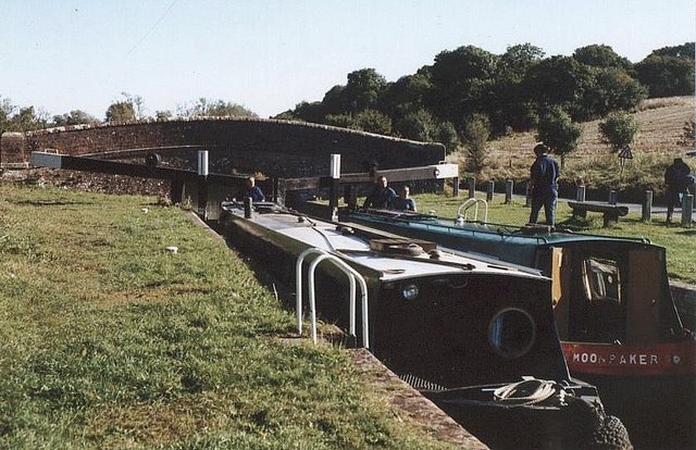
Oakhill Down Lock and Bridge
Bridge · 3.1 mi
Lock and bridge on the Kennet and Avon Canal in Froxfield, Wiltshire, England, UK
Museums and landmarks5

Roman villa of Littlecote
Monument and historic site · 1.7 mi
Roman rural estate at Littlecote, in Ramsbury, Wiltshire, England, UK

Membury Camp
Monument and historic site · 2.7 mi
Hillfort in Wiltshire/Berkshire, England, UK
Parks, trails and playgrounds1

Restaurants and cafes2
History
The Domesday Book of 1086 recorded a large settlement of 156 households at Ramesberie.
Littlecote Roman Villa is in the parish. The earliest written history of Ramsbury can be traced from the Saxon era, when the bishopric of Ramsbury was created in 909 AD.
Throughout the Middle Ages, Ramsbury traditionally held two annual fairs – a livestock fair in the spring, and a hiring fair or Mop fair at Michaelmas. Nearby Marlborough's tradition of holding one Mop each side of Michaelmas ("Little Mop" on the Saturday before and "Big Mop" on the Saturday after) was originally a means to accommodate the (then) more prestigious Ramsbury Mop. By the 19th century, both fairs had become cattle fairs. The spring cattle fair (traditionally held on 14 May) ceased in 1939. The Michaelmas fair slowly lost its original agricultural connections, becoming purely a funfair in 1946 before ceasing in the 1950s.
Between 1942 and 1946, during the Second World War, there was a Royal Air Force airfield known as RAF Ramsbury on a ridge of high ground to the south of the village.
An annual carnival was instituted to replace the fairs and survived until the 1990s, but has in turn been replaced with a biennial street fair which sees the High Street closed from the Square to the Memorial Hall.
Read more of the history
The Provident Union Investment Society was founded in Ramsbury in 1846, becoming the Ramsbury Building Society in 1928. It had its headquarters in the Square until 1982 and took as its logo the ancient wych-elm which grew immediately opposite. Subsequent mergers saw the building society subsumed into the Regency and West of England Building Society, then the Portman Building Society, and finally the Nationwide Building Society.
From the History section of Ramsbury on Wikipedia, under CC BY-SA 4.0.
More about Ramsbury
Education
From 1786 to the 1840s, Edward and Arthur Meyrick ran a school at Ramsbury Hill House on Back Lane and a girls' school was funded by Louisa Read of Crowood House (d.1879). In 1878, Mary Jane Lanfear left £600 to fund apprenticeships for local boys. The Lanfear Educational Trust still operates, making small educational grants to young people in Ramsbury and Axford.
In 1875, a board school was built on Back Lane, opposite Isles Road. It is now a private residence. Today, Ramsbury Pre-School and Primary School are in modern buildings on Isles Road, while secondary education is provided at St John's School, Marlborough.
From the Wikipedia article Ramsbury, under CC BY-SA 4.0.
Notable people from Ramsbury
 Edward MeyrickEnglish entomologist and schoolmaster (1854-1938)Photo: Unknown author Unknown author, Public domain
- Violet OwenBritish tennis player (1902-1998)
Born in Ramsbury, according to Wikidata (CC0). Each name links to its Wikipedia article.
Where to stay1
Churches and places of worship1
Schools, colleges and libraries2
Map of Ramsbury
13 places. The map loads OpenStreetMap tiles when you open it.
Getting there and nearby towns
Upavon Airfield (UPV) is the nearest airport with scheduled flights listed in OpenStreetMap, 13 miles away.
- Swindon 11 mi northwest, about 18 min by car
- Newbury 12 mi east, about 20 min by car
- Wantage 13 mi northeast, about 20 min by car
- Lydiard Millicent 14 mi northwest, about 23 min by car
- Thatcham 15 mi east, about 24 min by car
- Royal Wootton Bassett 15 mi northwest, about 24 min by car
- Tidworth 15 mi south, about 24 min by car
- Andover 17 mi south, about 27 min by car
- Calne 17 mi west, about 28 min by car
- Devizes 18 mi west, about 29 min by car
Drive times are estimates from straight-line distance, not routes.
Towns near Ramsbury


Keep exploring
Local news
Headlines from INDB.
Reviews, tips and questions
Loading what members have shared...
Sources and licences
- GeoNames (CC BY 4.0): population, coordinates, regions and time zone
- Mapillary (see each image): photos
- OpenStreetMap contributors (ODbL 1.0): places, airports, map data
- Wikidata (CC0 1.0): elevation, founding date, time zone, website, landmarks and historic places
- Wikimedia Commons (see each image): photos
- Wikipedia (CC BY-SA 4.0): overview and history text
Photo credits
- Oakhill Down Lock - No.68 - Kennet & Avon Canal, Maurice Pullin, CC BY-SA 2.0
- Littlecote plan, Udimu, CC BY-SA 3.0
- Street-level photo, swinetown, CC BY-SA 4.0
- Street-level photo, themadcabbie, CC BY-SA 4.0
- Street-level photo, themadcabbie, CC BY-SA 4.0
- Street-level photo, RyanBush, CC BY-SA 4.0
- Street-level photo, themadcabbie, CC BY-SA 4.0
Page built November 10, 2026. Spotted a mistake? Tell us or suggest a place.