


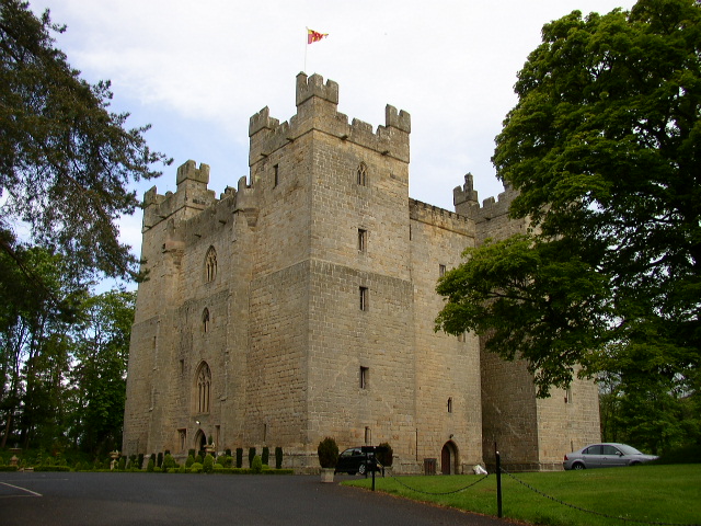
Haydon Bridge, United Kingdom
Haydon Bridge is a town of 1,557 people in England, United Kingdom.
Why visit Haydon Bridge
Townapedia lists 2 museums and landmarks, 4 places to eat, 4 places to stay and 6 attractions in and around town.
Highlights include Haydon Bridge Viaduct, New Haydon Bridge and Mr George's Museum of Time.
Weather in Haydon Bridge
Forecast from MET Norway (CC BY 4.0). Full forecast
About Haydon Bridge
Haydon Bridge is a village in Northumberland, England, which had a population of 2,184 in the 2011 census. Its most distinctive features are the two bridges crossing the River South Tyne: the picturesque original bridge after which the village was named (now restricted to pedestrian use) and a modern bridge which used to carry the A69 road. A bypass was completed in 2009 and the A69 now bypasses the village to the south.
From the Wikipedia article Haydon Bridge (this version), under CC BY-SA 4.0.
Things to do6
Old Haydon Bridge
Bridge
Grade II listed bridge in Haydon, Northumberland, England, UK


Ridley Bridge
Bridge · 2.8 mi
Bridge in Bardon Mill, Northumberland, England, UK
Museums and landmarks2
Restaurants and cafes4
Haydon Bridge Fish & Chips
Fast food · Fish And Chips
2 John Martin Street, Hexham


Where to stay4



Poplars Riverside Caravan Park
Campground · 0.4 mi
Land Ends Road, Hexham
History
In 1323 a Charter was granted for a market and fair to be held in the village, but as these gatherings so often ended in brawls between various families they did not add to the peace of the district.
In October 1587, a raid into Tynedale by 400 Scottish attackers led by Kinmont Willie Armstrong, led to the partial destruction of Haydon Bridge
From the History section of Haydon Bridge on Wikipedia, under CC BY-SA 4.0.
More about Haydon Bridge
Economy
A few years ago the 'old foundry' as locals called it (based on its earlier use as an ironworks established in 1843) was demolished to make way for new accommodation specifically for past and present Haydon Bridge residents. The new flats are modern buildings designed to fit in with the rest of the architecture of the village.
From the Wikipedia article Haydon Bridge, under CC BY-SA 4.0.
Notable people from Haydon Bridge
 John MartinEnglish painter, engraver and illustrator (1789–1854)Photo: Henry Warren, Public domain
- George AndersonScottish footballer and manager born in 1887
Born in Haydon Bridge, according to Wikidata (CC0). Each name links to its Wikipedia article.
Churches and places of worship3
Shopping1
Schools, colleges and libraries3
Healthcare1
Map of Haydon Bridge
24 places. The map loads OpenStreetMap tiles when you open it.
Getting there and nearby towns
Newcastle International Airport (NCL) is the nearest airport with scheduled flights listed in OpenStreetMap, 22 miles away.
- Hexham 6 mi east, about 9 min by car
- Prudhoe 16 mi east, about 25 min by car
- Wylam 17 mi east, about 27 min by car
- Consett 18 mi southeast, about 30 min by car
- Stanhope 18 mi southeast, about 29 min by car
- Heddon on the Wall 18 mi east, about 29 min by car
- Newburn 20 mi east, about 32 min by car
- Ponteland 21 mi east, about 33 min by car
- Blaydon-on-Tyne 21 mi east, about 34 min by car
- Newcastle upon Tyne 25 mi east, about 40 min by car
Drive times are estimates from straight-line distance, not routes.
Towns near Haydon Bridge


Keep exploring
Local news
Headlines from INDB.
Reviews, tips and questions
Loading what members have shared...
Sources and licences
- GeoNames (CC BY 4.0): population, coordinates, regions and time zone
- Mapillary (see each image): photos
- OpenStreetMap contributors (ODbL 1.0): places, airports, map data
- Wikidata (CC0 1.0): elevation, founding date, time zone, website, landmarks and historic places
- Wikimedia Commons (see each image): photos
- Wikipedia (CC BY-SA 4.0): overview and history text
Photo credits
- Haydon Bridge from the south west, Andrew Curtis, CC BY-SA 2.0
- Ridley railway bridge, Mike Quinn, CC BY-SA 2.0
- Anchor Hotel and Old Bridge, Haydon Bridge, Sadgrovem, CC BY-SA 4.0
- Langley Castle, Ken Brown, CC BY-SA 2.0
- Street-level photo, victuallers, CC BY-SA 4.0
- Street-level photo, victuallers, CC BY-SA 4.0
- Street-level photo, victuallers, CC BY-SA 4.0
- Street-level photo, victuallers, CC BY-SA 4.0
- Street-level photo, victuallers, CC BY-SA 4.0
- Street-level photo, victuallers, CC BY-SA 4.0
- Street-level photo, victuallers, CC BY-SA 4.0
- Street-level photo, victuallers, CC BY-SA 4.0
- Street-level photo, victuallers, CC BY-SA 4.0
- Street-level photo, victuallers, CC BY-SA 4.0
Page built November 10, 2026. Spotted a mistake? Tell us or suggest a place.