


Why visit Highley
Townapedia lists 3 museums and landmarks, 1 park or trail, 13 places to eat, 1 place to stay and 1 attraction in and around town.
Highlights include Victoria Bridge, The Engine House, Dudmaston Hall and Severn Valley Country Park.
Weather in Highley
Forecast from MET Norway (CC BY 4.0). Full forecast
About Highley
Highley is a village and civil parish in the county and district of Shropshire, England. It is located on the west bank of the River Severn and is 7 miles (11 km) south east of Bridgnorth.
From the Wikipedia article Highley (this version), under CC BY-SA 4.0.
Photos of Highley

Things to do1

Victoria Bridge
Bridge · 3.1 mi
Bridge crossing the River Severn in Worcestershire, England, UK
Museums and landmarks3


Dudmaston Hall
Museum · 3.3 mi
Country house in Shropshire, England, UK

Parks, trails and playgrounds1

Severn Valley Country Park
Park · 0.8 mi
Park in Shropshire, United Kingdom
Restaurants and cafes13




1 more on the map.
History
Highley began as a rural farming community, including an entry in the Domesday Book, later becoming a significant area for stone quarrying which provided some of the stone for Worcester Cathedral. Coal mining began in the area in the Middle Ages, but in the late 19th century the village was revolutionised by coal mining with large-scale operations beginning in 1878. A period of intense housebuilding also followed, giving Highley its distinctive red-brick terraced miners' houses. In the 1930s, the mine was extended to the neighbouring village of Alveley across the River Severn and a tunnel and bridge constructed between the two. There are also historical bridging points at Bridgnorth to the north and Bewdley to the south, and in Hampton Loade a private bridge used by the emergency services.
The mine closed in 1969 due to subsidence and waterlogging. The bridge remained open to bridleway traffic only, due to subsidence from the steep valley sides. The mine area on the Alveley (east) side was converted into an industrial estate as coal mining ceased, and subsequently landscaped into the Severn Valley Country Park in the late 1980s. Initially this was as an exercise to use trees to shore up the coal spoils, and later as a tourist destination which now includes public artwork and a sculpture trail, the Seam Pavement Trail.
Read more of the history
The trail is a series of seven bronze plaques depicting Highley's past and incorporates the designs of West Midlands artist Saranjit Birdi. He included many miner's nicknames into the artwork, gleaned from archive information and research within the local community. Nicknames of the miners, such as Dick the Devil, Joyful Clappers, Cider Biscuit, Flaming Heck and others, are incorporated into the work. Birdi calls it "a seam through time", echoing the skilfully mined coal seams being laid down and later extracted over time. One plaque, Plough and Lady, depicts Lady Godiva, who owned Highley Manor in the 11th century. Birdi is also responsible for another sculpture, A Song of Steam, at Highley station.
In 2000, the bridge was declared unsafe and a new footbridge constructed (completed 2006).
Highley was the village where 17-year-old murder victim Lesley Whittle lived, and from which she was abducted by Donald Neilson, the Black Panther, in 1975. Lesley, the daughter of coach firm owner George Whittle (1905–1970), was taken from her home on 13 January 1975 and found dead on an underground ledge beneath Bathpool Park near Kidsgrove, Staffordshire, on 7 March that year. Neilson was found guilty of murdering Lesley Whittle and three other people (as well as wounding a Dudley security guard, who later died having never fully recovered from his injuries) at his trial in the summer of 1976, and sentenced to life imprisonment. Lesley Whittle's funeral took place at Highley Parish Church. A memorial plaque to Lesley and her father is in the porch of the church.
From the History section of Highley on Wikipedia, under CC BY-SA 4.0.
More about Highley
Arts and culture
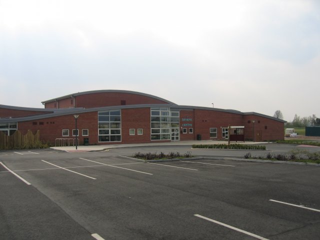
Highley houses the Severn Centre, a sports and leisure complex complete with heated lido (open-air swimming pool) that also includes the local library, football ground and cricket pitch. (Latter frequently used to exercise dogs despite dogs being banned.) There is also a Country Park, the sculpture trail plus several restaurants and pubs.
The Highley Colliery Brass Band is a local brass band which first existed from the turn of the 19th century until the closure of the colliery in 1969. It reformed in 1993 when a handful of brass band musicians met at the Bache Public House in Highley. Member numbers grew, and under the baton of Ray Millichamp the band began performances under the name of Highley Band. In 2000, to coincide with the new uniform, the band adopted a Pit Head Wheel emblem and was renamed Highley Colliery Band, to reflect the mining heritage of its home village.
From the Wikipedia article Highley, under CC BY-SA 4.0.
Notable people from Highley
- Mark HumphriesEnglish cricketer (born 1965)
- Aubrey ScrivenEnglish footballer (1904-1988)
- Stan Jonesassociation football player
Born in Highley, according to Wikidata (CC0). Each name links to its Wikipedia article.
Where to stay1
Churches and places of worship3
Schools, colleges and libraries2
Healthcare1
Map of Highley
25 places. The map loads OpenStreetMap tiles when you open it.
Getting there and nearby towns
Birmingham Airport (BHX) is the nearest airport with scheduled flights listed in OpenStreetMap, 27 miles away.
- Alveley 1 mi northeast, about 2 min by car
- Bridgnorth 6 mi north, about 10 min by car
- Kidderminster 7 mi southeast, about 11 min by car
- Stourport-on-Severn 9 mi southeast, about 14 min by car
- Stourbridge 10 mi east, about 16 min by car
- Kingswinford 10 mi east, about 15 min by car
- Wombourne 10 mi northeast, about 16 min by car
- Hartlebury 10 mi southeast, about 16 min by car
- Brierley Hill 11 mi east, about 18 min by car
- Dudley 13 mi east, about 21 min by car
Drive times are estimates from straight-line distance, not routes.
Towns near Highley


Keep exploring
Local news
Headlines from INDB.
Reviews, tips and questions
Loading what members have shared...
Sources and licences
- GeoNames (CC BY 4.0): population, coordinates, regions and time zone
- OpenStreetMap contributors (ODbL 1.0): places, airports, map data
- Wikidata (CC0 1.0): elevation, founding date, time zone, website, landmarks and historic places
- Wikimedia Commons (see each image): photos
- Wikipedia (CC BY-SA 4.0): overview and history text
Photo credits
- Severn Centre, Highley, David Stowell, CC BY-SA 2.0
- Highley Church, Gammock, CC BY-SA 4.0
- Highley Church - panoramio, Tanya Dedyukhina, CC BY 3.0
- Highley Ancient house - panoramio, Tanya Dedyukhina, CC BY 3.0
- Ancient house Highley - panoramio, Tanya Dedyukhina, CC BY 3.0
- 6695 Victoria Bridge Severn Valley Railway, Duncan Harris, CC BY-SA 2.0
- Alveley Church, Gammock, CC BY-SA 4.0
- Ancient house behind the church - panoramio, Tanya Dedyukhina, CC BY 3.0
- LMs 8F 2-8-0 48773, GWR 0-6-0PT 1501, GWR 4-6-0 4930 'Hagley Hall' & BR 4MT 2-6-4T 80079 The Engine House, Highley, SVR 20.08.09 (10256721175), Gillett's Crossing from Bristol, United Kingdom, CC BY 2.0

Page built November 10, 2026. Spotted a mistake? Tell us or suggest a place.