
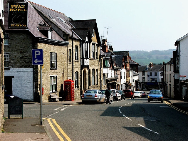


Why visit Kington
Townapedia lists 5 museums and landmarks, 5 parks and trails, 14 places to eat, 3 places to stay and 2 attractions in and around town.
Highlights include Small Breeds Farm Park, Bradnor Hill, Kington Museum and Kington Museum and History Centre.
Weather in Kington
Forecast from MET Norway (CC BY 4.0). Full forecast
About Kington
Kington is a market town and civil parish in Herefordshire, England. It is situated on the River Arrow, near the England-Wales border, approximately 16 miles (26 km) northwest of Hereford, 34 miles (55 km) west of Worcester, and 78 miles (126 km) west-southwest of Birmingham. The parish had a population of 2,639 at the 2021 census.
From the Wikipedia article Kington, Herefordshire (this version), under CC BY-SA 4.0.
Travel tips from other travellers: Kington on Wikivoyage (CC BY-SA 4.0).
Things to do2


Museums and landmarks5

Kington Museum and History Centre
Museum
Museum in Herefordshire, England, United Kingdom


Parks, trails and playgrounds5


Restaurants and cafes14



2 more on the map.
History
The name Kington is derived from 'King's-ton', being Anglo-Saxon for "King's Town", similar to other nearby towns such as Presteigne meaning "Priest's Town" and Knighton being "Knight's Town".
Read more of the history
The land on which Kington is sited was held by Anglo-Saxons in 1066, but devastated. After the Norman Conquest Kington then passed to the Crown on the downfall in 1075 of Roger de Breteuil, 2nd Earl of Hereford. Before 1121, King Henry I gave Kington to Adam de Port, who founded a new Marcher barony in this part of the early Welsh Marches. Kington seems to have been a quiet barony and was associated with the office of sheriff of Hereford. In 1172, Adam de Port, probably the great-grandson of Henry Port, rebelled and fled the country. He returned in 1174 with a Scottish army, only to flee from the resulting Battle of Alnwick to the great mirth of the Norman court. With this his barony of Kington was taken by the Crown and became an appurtenance of the office of Sheriff of Hereford, finally being granted to William de Braose, 4th Lord of Bramber in 1203 for £100. The castle then saw action in the Braose Wars against King John, and is likely to have been destroyed by royal forces in August 1216. Within a few years a new fortress was commenced and the nearby Huntington Castle and Kington Castle were abandoned. All that remains of Kington Castle today is a great outcrop of rock topped by a few fragmentary earthworks. The old town clustered around the castle and Norman church on top of a defensive hill above the River Arrow.
‘Chingtune' was recorded in the Domesday Book in 1086, the name meaning 'king's town or manor', high on the hill above the town where St. Mary's Church now stands. The new Kington, called Kyneton in the Fields, was laid out between 1175 and 1230 on land bordering the River Arrow and possibly designated as part of the Saxon open-field system.
Situated on the direct route the drovers took from Hergest Ridge and with eight annual fairs, Kington grew in importance as a market town, and there is still a thriving livestock market on Thursdays. The town retains the medieval grid pattern of streets and back lanes.
In the chapel of St. Mary's Church, there is the alabaster tomb of Sir Thomas Vaughan of nearby Hergest Court, slain at the Battle of Banbury in 1469, and his wife, Elen Gethin. The ghost of Sir Thomas, and also that of the Black Dog of Hergest, are said to haunt the area around Hergest Ridge. The Black Dog's sighting reputedly presages death.
From the History section of Kington, Herefordshire on Wikipedia, under CC BY-SA 4.0.
More about Kington
Geography
Kington is 2.0 miles (3.2 km) from the border with Wales, and lies on the western side of Offa's Dyke. The town is in the shadow of Hergest Ridge, and on the River Arrow, where it is crossed by the A44 road. It is 19 miles (31 km) northwest of Hereford, the county town. Nearby towns include Presteigne, Builth Wells, Knighton and Leominster. The centre of the town is situated at 522 feet (159 m) above sea level. The civil parish covers an area of 860 acres (350 ha).
Economy
In the 13th century the new medieval town was formed at the foot of the hill and became primarily a wool-trading market town on an important drovers' road. Its location and historic character is the reason why so many waymarked long-distance footpaths pass through Kington today, including the Mortimer Trail, the Herefordshire Trail and the Offa's Dyke Path. The Black and White Village Trail follows the half-timbered cottages and houses in local Herefordshire villages.
Arts and culture
Kington Museum is open April to September inclusive, and is on Mill Street in the town centre. Near the town is Hergest Croft Gardens, part of the Hergest Estate, which is open to the public March to October. In June, for several weeks, is the annual Kington Festival in the town.
Ye Olde Tavern is a late 18th/early 19th century Grade II listed public house at 22 Victoria Rd. It is on the Campaign for Real Ale's National Inventory of Historic Pub Interiors.
The Oxford Arms on Duke Street is a Grade II-listed former coaching inn with an 18th-centurey building recorded on the national heritage list for England. In 2923, the property was purcahsed by Open Arms Kington, a community interest company, with plans to restpre it as a community pub and multi-purpose venue. The project was awarded development funding by the national Lottery Heritage Fund in November 2024.
The Burton Hotel is a hotel and health centre, on Mill Street. The town also has a Youth Hostel on Victoria Road, which is open from late March to late October.
Education
The town has a primary school and a combined secondary school and sixth form — the Lady Hawkins' School. Sir Francis Drake's cousin Sir John Hawkins married, and in her will, Lady Hawkins left £800 to the town to establish the school. The school is unique in having special permission from the Royal Navy to fly the White Ensign on its foundress day. Notable former students include singer Ellie Goulding and actor Jessica Raine.
From the Wikipedia article Kington, Herefordshire, under CC BY-SA 4.0.
Notable people from Kington
 Stephen KembleBritish actor and theatre manager (1758-1822)Photo: unknown, Public domain
 Walter Russell HallAustralian businessman (1831-1911)Photo: Frederick McCubbin, Public domain
- Chris MengesBritish cinematographer and film director
- Wilfred BurnsBritish film score composer (1917–1990)
- Thomas HillEnglish puritan divine
- Thomas Arndell(1753-1821) surgeon, magistrate and landholder
Born in Kington, according to Wikidata (CC0). Each name links to its Wikipedia article.
Where to stay3
Churches and places of worship5
Shopping7
Gas and EV charging1
Schools, colleges and libraries3
Healthcare2
Map of Kington
47 places. The map loads OpenStreetMap tiles when you open it.
Getting there and nearby towns
Gloucestershire Airport (GLO) is the nearest airport with scheduled flights listed in OpenStreetMap, 42 miles away.
- Leominster 12 mi east, about 19 min by car
- Credenhill 12 mi southeast, about 20 min by car
- Hereford 17 mi southeast, about 27 min by car
- Ludlow 18 mi northeast, about 28 min by car
- Craven Arms 18 mi northeast, about 30 min by car
- Lugwardine 18 mi southeast, about 29 min by car
- Ewyas Harold 18 mi south, about 29 min by car
- Bishop's Castle 20 mi north, about 32 min by car
- Newtown 25 mi northwest, about 39 min by car
- Abergavenny 26 mi south, about 43 min by car
Drive times are estimates from straight-line distance, not routes.
Towns near Kington


Keep exploring
Local news
Headlines from INDB.
Reviews, tips and questions
Loading what members have shared...
Sources and licences
- GeoNames (CC BY 4.0): population, coordinates, regions and time zone
- Mapillary (see each image): photos
- OpenStreetMap contributors (ODbL 1.0): places, airports, map data
- Wikidata (CC0 1.0): elevation, founding date, time zone, website, landmarks and historic places
- Wikimedia Commons (see each image): photos
- Wikipedia (CC BY-SA 4.0): overview and history text
Photo credits
- Kington, Ruth Harris, CC BY-SA 2.0
- Side View of Kington Museum, Benjamin Richards, CC BY-SA 4.0
- Kington War Memorial, Dave.Dunford, CC BY-SA 4.0
- Hergest Croft Gardens - panoramio, PJMarriott, CC BY 3.0
- Street-level photo, southglos, CC BY-SA 4.0
Page built November 10, 2026. Spotted a mistake? Tell us or suggest a place.