


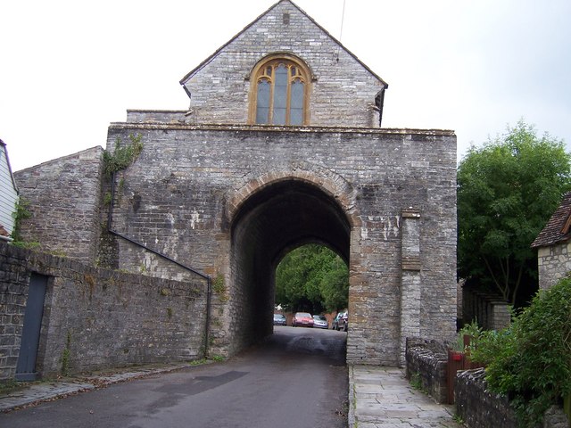

Why visit Langport
Townapedia lists 8 museums and landmarks, 12 places to eat and 1 place to stay in and around town.
Highlights include Muchelney Abbey and Burton Pynsent Monument.
Weather in Langport
Forecast from MET Norway (CC BY 4.0). Full forecast
About Langport
Langport is a town and civil parish in Somerset, England, 5 miles (8 km) west of Somerton. The parish, which covers only part of the town, has a population of 3,578. Langport is contiguous with Huish Episcopi, a separate parish that includes much of the town's outskirts.
From the Wikipedia article Langport (this version), under CC BY-SA 4.0.
Travel tips from other travellers: Langport on Wikivoyage (CC BY-SA 4.0).
Museums and landmarks8

Muchelney Abbey
Museum · 1.3 mi
Grade I listed historic house museum in South Somerset, England, UK

Burton Pynsent Monument
Monument and historic site · 2.9 mi
Grade I listed monument in Curry Rivel, Somerset, England, UK


The Priest's House
Museum · 1.3 mi
Grade II listed historic house museum in Muchelney, Somerset, England, UK
Taylor Monument In Churchyard, 7 Metres East Of Chancel, Church Of Saint Peter And Saint Paul
Monument and historic site · 1.3 mi

Restaurants and cafes12


Where to stay1

Churches and places of worship14


Church of All Saints, Langport
Church
Church in Langport, Somerset, England, UK

Church of Saint Andrew
Church · 1.9 mi
Church in South Somerset, England, UK
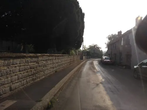
Church of St Catherine, Drayton
Church · 1.6 mi
Church in South Somerset, England, UK

Church of St Peter & St Paul
Church · Anglican · 1.3 mi
In the Parish of Muchelney In the Diocese of Bath and Wells
Church of St Peter and St Paul, Muchelney
Church · 1.3 mi
Church in Muchelney, Somerset, England, UK

Church of the Blessed Virgin Mary, Huish Episcopi
Church · 0.4 mi
Church in Huish Episcopi, Somerset, England, UK

Church without dedication, High Ham
Church · 1.6 mi
Church in Low Ham, Somerset, England, UK

St Andrew's Church
Church · 2.7 mi
Church in High Ham, Somerset, England, UK

Church of Saint John Baptist
Church · 1.8 mi
Church in Pitney, Somerset, England, UK
Church of the Holy Trinity, Long Sutton
Church · 3.2 mi
Church in Long Sutton, Somerset, England, UK
St Andrew's Church
Church · 2.0 mi
Church in Curry Rivel, Somerset, England, UK
2 more on the map.
History
Langport (old forms are "Langeberga" and "Langeport") consists of two parts, one on the hill and one by the River Parrett. The former owed its origin to its defensible position, and the latter its growth to its facilities for trade on the chief river of Somerset. Eilert Ekwall translates it as "long town" or "long market". Its name looks like Anglo-Saxon for "long port", but it may be "long market place" that could have been on the causeway that is now Bow Street.
Many of the houses in Bow Street tilt backwards due to settlement of the land behind the causeway. It is speculated that Langport is the place mentioned in old Welsh sources as "Llongborth" = "Ship-port", the site of the Battle of Llongborth. "Longphort" is a term used in Ireland for a Viking ship enclosure or shore fortress, with an identical etymology. Langport was previously also known as Langport Eastover, with the part on the western bank being Langport Westover, now known just as Westover. Langport is on the ancient way from Glastonbury to Taunton.
Read more of the history
Langport could have been important during the Roman occupation as there were several villas in the vicinity. It was one of the forts listed in the Burghal Hidage indicating its strategic position for King Alfred, as well as being close to the royal centre of Somerton. According to the Domesday Book of 1086, it had 34 resident burgesses and was worth the then large sum of £79 10s 7d.
The parish of Combe was part of the Kilmersdon Hundred, while Langport Eastover was within the Hundred of Pitney.
The first charter, granted by Elizabeth I in 1562, recognised that Langport was a borough of great antiquity, which had enjoyed considerable privileges, being governed by a portreeve. It was incorporated by James I in 1617, but the corporation was abolished in 1883. Langport was represented in Parliament in 1304 and 1306. In medieval times Langport was an important centre for cloth making.
The charter of 1562 granted three annual fairs to Langport, on 28 June, 11 November, and the second Monday in Lent. Only one fair is now held, a horse and cattle fair on 3 September. A Saturday market was held under the grant of 1562, but in the 19th century the market day was changed to Tuesday.
On 10 July 1645, the Battle of Langport was fought here, in which the last effective Royalist field army was destroyed and the Parliamentary victory in the Civil War became all but inevitable. When the Royalists retreated through the town many were killed by the bridge over the Parrett, and many of the buildings were set on fire. Although one authority states this was an act of the Parliamentary cavalry, reading contemporary accounts of the battle it is clear that the Royalist cavalry set the lower town on fire in the (vain) hope that this would hinder the pursuit led by Cromwell's cavalry.
In 1826 Langport was the birthplace of Walter Bagehot a businessman, essayist and journalist, who wrote extensively about literature, government, economic affairs and other topics. He went into partnership with George Stuckey and by 1866 the company owned 14 East Indiamen as well as 19 barges on the River Parrett. This developed into the Somerset Trading Company. Stuckey's Bank had been founded in 1770, and by 1909 its banknote circulation was second only to that of the Bank of England. It was then taken over by Parr's Bank, which became part of the Westminster Bank.
The Great Bow Bridge, which now carries the A378, is a three-arched bridge, constructed under the terms of the Parrett Navigation Act 1836. Completed in 1841 at a cost of £3,749, it replaced the previous medieval bridge, with its nine tiny arches, all too small to allow navigation. A bridge at this site was first mentioned in 1220. The medieval bridge consisted of a total of 31 arches, of which nine crossed the river, and 19 of the original arches were located by ground-penetrating radar in 1987, buried beneath the road which runs from Great Bow Bridge to Little Bow Bridge.
Around 1840 the Westport Canal was built, which joined the river at Langport. The abortive Ivelchester and Langport Navigation scheme had sought to avoid the Great Bow Bridge, by making the Portlake Rhine navigable, rebuilding Little Bow Bridge in the centre of Langport, and making a new cut to Bicknell's Bridge. Seven locks, each with a small rise, were planned but the scheme foundered in 1797, due to financial difficulties. The railway came to Langport in 1853 and opened up new markets, but caused the decline of river traffic.
In 1856 the proprietor of the Langport Herald, James Richard Moreton, printed and published the 107 hymn tunes and six anthems written by his father, who was the minister of Langport Independent Chapel. This was the Reverend James Moreton's Sacred Music, used by Congregationalists and other denominations in the 19th century; there is a copy in the British Library.
In World War II Langport was the site of a United States Army military prison or Disciplinary Training Center.
From the History section of Langport on Wikipedia, under CC BY-SA 4.0.
More about Langport
Geography
Langport lies on the east bank of the River Parrett, below the point where that river is joined by the River Yeo (Ivel). There is a causeway across the moor and an important bridge over the river. Below Langport the Parrett is tidal. The rivers flow from the southern hills through Thorney Moor and Kings Moor, through a gap between the upland areas around Somerton and Curry Rivel, onto the Somerset Levels through which it flows past Bridgwater to the Bristol Channel. During the winter the low-lying areas around Langport are sometimes flooded.
Langport Railway Cutting is a Geological Conservation Review site where Gravels are exposed which show scour-and-fill structures consistent with braided stream deposition from the Pleistocene age.
To the south of the town is Wet Moor, a biological Site of Special Scientific Interest which is part of the extensive grazing marsh grasslands and ditch systems of the Somerset Levels and Moors. In storm conditions the rivers can overtop their banks and overspill into the adjacent low-lying moorland. The rivers running through the moor make home for many wildlife, including wintering whooper swans.
Education
Education for children aged 11 to 18 is provided by Huish Episcopi Academy, a mixed secondary school with academy status. The school has a specialist status as a Science College and Language College. It has around 1,400 students.
Huish Episcopi Primary School — near the centre of Langport — takes pupils from the age of 4 to 11. The school serves Langport, Huish Episcopi, Aller, Muchelney, Pibsbury, Drayton and Pitney. The school site includes 7 classrooms, an ICT suite, hall, library, playground and school field. There are around 180 pupils.
St Gildas' School formerly provided private education, but is now closed.
From the Wikipedia article Langport, under CC BY-SA 4.0.
Notable people from Langport
 John Thomas QuekettEnglish microscopist and histologistPhoto: Unknown author, CC BY 4.0
 Digby DenhamAustralian politician (1859-1944)Photo: File:Digby Denham.jpg : Unknown..., Public domain
- Walter BagehotBritish journalist, businessman, and essayist (1826-1877)
- George Majorcricketer (1851-1921)
- Edwin John QuekettBritish botanist (1808–1847)
- Henry Sawtellmayor of Christchurch, New Zealand
- Jacquemine Charrott LodwidgeBritish bookseller
- Emma OverdBritish folk singer
- Vincent StuckeyEnglish banker; (1771-1845)
- Jamil RobertsEnglish football player
- Fischer WatsonCommander of the Order of the British Empire (1884-1960)
Born in Langport, according to Wikidata (CC0). Each name links to its Wikipedia article.
Shopping3
Gas and EV charging1
Schools, colleges and libraries3
Healthcare1
Map of Langport
43 places. The map loads OpenStreetMap tiles when you open it.
Getting there and nearby towns
Royal Naval Air Station Yeovilton (YEO) is the nearest airport with scheduled flights listed in OpenStreetMap, 8 miles away.
- Curry Rivel 2 mi southwest, about 3 min by car
- South Petherton 6 mi south, about 10 min by car
- Street 7 mi northeast, about 11 min by car
- Westonzoyland 7 mi northwest, about 11 min by car
- Stoke-sub-Hamdon 7 mi southeast, about 11 min by car
- Ilchester 7 mi east, about 11 min by car
- North Petherton 9 mi northwest, about 14 min by car
- Merriott 9 mi south, about 14 min by car
- Bridgwater 10 mi northwest, about 16 min by car
- Yeovil 11 mi southeast, about 17 min by car
Drive times are estimates from straight-line distance, not routes.
Towns near Langport


Keep exploring
Local news
Headlines from INDB.
Reviews, tips and questions
Loading what members have shared...
Sources and licences
- GeoNames (CC BY 4.0): population, coordinates, regions and time zone
- Mapillary (see each image): photos
- OpenStreetMap contributors (ODbL 1.0): places, airports, map data
- Wikidata (CC0 1.0): elevation, founding date, time zone, website, landmarks and historic places
- Wikimedia Commons (see each image): photos
- Wikipedia (CC BY-SA 4.0): overview and history text
Photo credits
- Langport Parrett, hughelli, CC BY-SA 3.0
- Langport, Somerset, "Carpenters Box" post box featuring some standard Ludlow box parts, kitmasterbloke, CC BY 2.0
- All Saints Hall, Langport, Simon Burchell, CC BY-SA 4.0
- Langport 05, Simon Burchell, CC BY-SA 4.0
- Hanging chapel Langport, Pam Goodey, CC BY-SA 2.0
- All Saints' Church, Langport, Somerset (5526999731), Robert Cutts from Bristol, England, UK, CC BY 2.0
- Allerchurch, Dbown100, CC BY 3.0
- St. Mary's Church, Huish Episcopi 04, Simon Burchell, CC BY-SA 4.0
- Low Ham church, nick macneill, CC BY-SA 2.0
- High Ham church, Bill Stilling, CC BY-SA 2.0
- Priesthouse, User:Celiakozlowski, CC BY 3.0
- Muchelney Church (St. Peter & St. Paul) (35913905955), Hugh Llewelyn from Keynsham, UK, CC BY-SA 2.0
- Huish Episcopi Academy, Rodw, CC0
- Muchelney Abbey 1, Val Ghose, CC BY-SA 2.0
- Muchelney Abbey. - panoramio, Robert Powell, CC BY-SA 3.0
- Burton Pynsent Monument 2, Edward Purves, CC BY-SA 3.0
- Street-level photo, southglos, CC BY-SA 4.0
- Street-level photo, southglos, CC BY-SA 4.0
- Street-level photo, southglos, CC BY-SA 4.0
- Street-level photo, ukchris, CC BY-SA 4.0
- Street-level photo, ukchris, CC BY-SA 4.0
- Street-level photo, southglos, CC BY-SA 4.0
- Street-level photo, southglos, CC BY-SA 4.0
- Street-level photo, southglos, CC BY-SA 4.0
- Street-level photo, southglos, CC BY-SA 4.0
- Street-level photo, ukchris, CC BY-SA 4.0
- Street-level photo, ukchris, CC BY-SA 4.0
- Street-level photo, southglos, CC BY-SA 4.0
- Street-level photo, southglos, CC BY-SA 4.0
- Street-level photo, ukchris, CC BY-SA 4.0
- Street-level photo, southglos, CC BY-SA 4.0
- Street-level photo, southglos, CC BY-SA 4.0
- Street-level photo, southglos, CC BY-SA 4.0

Page built November 10, 2026. Spotted a mistake? Tell us or suggest a place.