


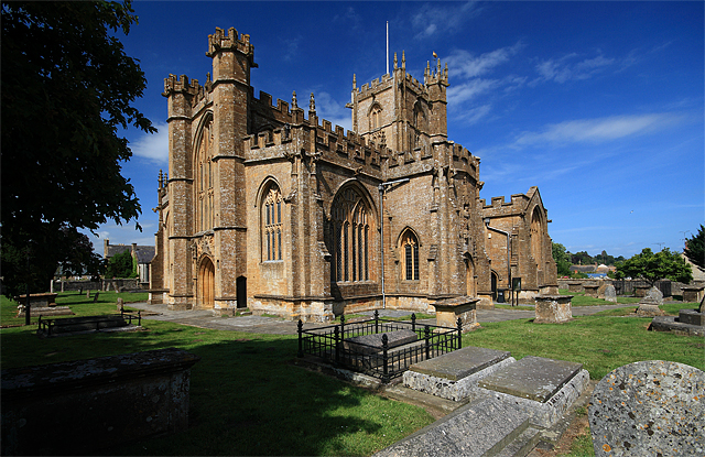


Why visit Merriott
Townapedia lists 1 museum or landmark, 2 places to eat and 1 attraction in and around town.
Highlights include Haselbury Old Bridge and Crewkerne and District Museum and Heritage Centre.
Weather in Merriott
Forecast from MET Norway (CC BY 4.0). Full forecast
About Merriott
Merriott is a village and civil parish in Somerset, England, near the town of Crewkerne and 7 miles (11.3 km) west of Yeovil in the South Somerset district. The village has a population of 1,979.
From the Wikipedia article Merriott (this version), under CC BY-SA 4.0.
Things to do1

Haselbury Old Bridge
Bridge · 1.6 mi
Bridge in Haselbury Plucknett, South Somerset, England, UK
Museums and landmarks1

Crewkerne and District Museum and Heritage Centre
Museum · 1.9 mi
Local museum in Somerset, United Kingdom
Restaurants and cafes2

Churches and places of worship19

Christ Church, Crewkerne
Church · 2.1 mi
Church building in Crewkerne, South Somerset, England, UK

Church of All Saints
Church
Church in Merriott, Somerset, England, UK

Church of All Saints, Lopen
Church · 1.4 mi
Church in Lopen, Somerset, England, UK
Church of Saint Mary
Church · 1.6 mi
Church building in West and Middle Chinnock, South Somerset, England, UK

Church of St Bartholomew, Crewkerne
Church · 2.2 mi
Church in South Somerset, England, UK

Church of St George, Hinton St George
Church · 1.5 mi
Church in Hinton St George, Somerset, England, UK

Church of St Mary the Virgin, Norton-sub-Hamdon
Church · 2.6 mi
Church in Norton-sub-Hamdon, Somerset, England, UK

Church of St Mary, Seavington St Mary
Church · 2.7 mi
Church in South Somerset, England, UK

Church of Saint Margaret
Church · 1.9 mi
Church in Middle Chinnock, Somerset, England, UK
Church of St Martin, North Perrott
Church · 2.9 mi
Church in North Perrott, Somerset, England, UK
Church of St Michael
Church · 2.3 mi
Church in Seavington St Michael, Somerset, England, UK
Church of St Michael and All Angels
Church · 2.2 mi
Historic church in Haselbury Plucknett, Somerset, England, United Kingdom
7 more on the map.
History
The name Merriott means boundary gate from the Old English Maergeat.
The manor was held at the time of the Domesday Book in 1086 by Harding son of Eadnorth whose descendants took the name of the village and continued until the death of Sir John de Meriet in 1391. The good quality of the soil led to the development of market-gardening, with the first use in England of the word nursery (noresire) occurred at Merriot in 1369.
Major rebuilding took place in the village following a fire in 1811.
The school building dates from 1876, and now incorporates the former Sunday school which was built in 1834.
From the History section of Merriott on Wikipedia, under CC BY-SA 4.0.
Notable people from Merriott
- Francis TraskNew Zealand mayor
Born in Merriott, according to Wikidata (CC0). Each name links to its Wikipedia article.
Gas and EV charging1
Schools, colleges and libraries2
Hinton St George Church of England Primary School
School · Anglican · 1.5 mi
West Street, Hinton St George
Map of Merriott
26 places. The map loads OpenStreetMap tiles when you open it.
Getting there and nearby towns
Royal Naval Air Station Yeovilton (YEO) is the nearest airport with scheduled flights listed in OpenStreetMap, 9 miles away.
- West Coker 5 mi east, about 8 min by car
- Yeovil 7 mi east, about 12 min by car
- Chard 8 mi west, about 13 min by car
- Ilchester 8 mi northeast, about 13 min by car
- Curry Rivel 8 mi north, about 13 min by car
- Yetminster 9 mi east, about 15 min by car
- Bridport 12 mi south, about 20 min by car
- Creech Saint Michael 13 mi northwest, about 21 min by car
- Taunton 15 mi northwest, about 24 min by car
- Street 15 mi north, about 24 min by car
Drive times are estimates from straight-line distance, not routes.
Towns near Merriott


Keep exploring
Local news
Headlines from INDB.
Reviews, tips and questions
Loading what members have shared...
Sources and licences
- GeoNames (CC BY 4.0): population, coordinates, regions and time zone
- Mapillary (see each image): photos
- OpenStreetMap contributors (ODbL 1.0): places, airports, map data
- Wikidata (CC0 1.0): elevation, founding date, time zone, website, landmarks and historic places
- Wikimedia Commons (see each image): photos
- Wikipedia (CC BY-SA 4.0): overview and history text
Photo credits
- All Saints Merriot, Sarah Smith, CC BY-SA 2.0
- Christchurch Court South Street Crewkerne Somerset, Ashley Smith, CC BY-SA 4.0
- Lopen church, Stevekeiretsu, CC BY-SA 4.0
- St Bartholomew Crewkerne, Mike Searle, CC BY-SA 2.0
- Hintonstgchurch, Dbown100, CC BY 3.0
- St Mary the Virgin parish church, Norton-sub-Hamdon, Somerset, seen from the southeast, David Bown, CC BY 3.0
- Seavington St Mary church, Somerset, Stevekeiretsu, CC BY-SA 4.0
- Crewkerne Museum & Heritage Centre, Ashley Smith, CC BY-SA 4.0
- Street-level photo, ukchris, CC BY-SA 4.0
- Street-level photo, richardc, CC BY-SA 4.0
- Street-level photo, ukchris, CC BY-SA 4.0
Page built November 10, 2026. Spotted a mistake? Tell us or suggest a place.