


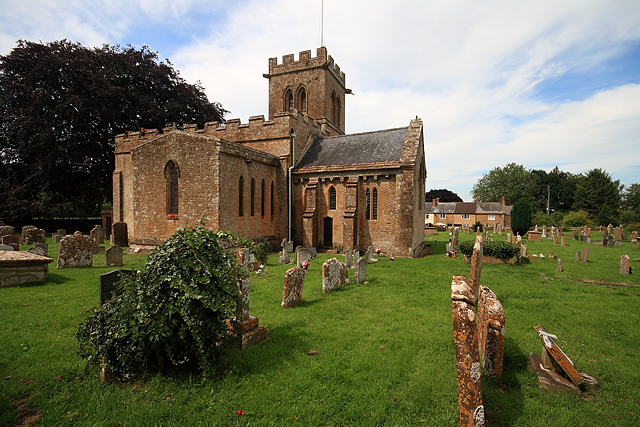


Stoke-sub-Hamdon, United Kingdom
Stoke-sub-Hamdon is a town of 2,004 people in England, United Kingdom.
Why visit Stoke-sub-Hamdon
Townapedia lists 13 museums and landmarks, 2 parks and trails, 16 places to eat, 3 places to stay and 5 attractions in and around town.
Highlights include Ham Hill, Montacute Castle, Ham Hill and Ham Hill Hillfort.
Weather in Stoke-sub-Hamdon
Forecast from MET Norway (CC BY 4.0). Full forecast
About Stoke-sub-Hamdon
Stoke-sub-Hamdon (or Stoke sub Hamdon), also known as Stoke under Ham, is a large village and civil parish in Somerset, England. It is situated 5 miles (8 km) west of Yeovil, with which it is linked by the A3088 road. The parish is located near the River Parrett, and includes the village of East Stoke.
From the Wikipedia article Stoke-sub-Hamdon (this version), under CC BY-SA 4.0.
Photos of Stoke-sub-Hamdon


Things to do5

Museums and landmarks13

Ham Hill
Monument and historic site · 0.7 mi
Hillfort in Somerset, England, UK

Montacute House
Museum · 1.6 mi
Late Elizabethan mansion with garden in Montacute, South Somerset, England, UK

Montacute Priory
Monument and historic site · 1.4 mi
Priory in Somerset, England, UK

Treasurer's House
Museum · 1.5 mi
Grade I listed historic house museum in South Somerset, England, UK

1 more on the map.
Parks, trails and playgrounds2

Restaurants and cafes16

The Phelips Arms
Bar and pub · 1.5 mi
The Borough, Montacute
We-Th 12:00-15:00,18:00-22:00; Fr-Sa 12:00-15:00,18:00-23:00; Su...





4 more on the map.
History
The village stretches around Ham Hill which is a geological Site of Special Scientific Interest (SSSI), Iron Age hillfort, Roman site and country park. The hill has given its name to the distinctive quarried hamstone which is quarried from a ridge of sandy limestone rock that is elevated above the lower lying clay vales and nearby Somerset Levels. It is of particular importance to geologists because of the assemblages of fossils which it contains, the sedimentary features which it displays and the way it relates to other rocks of equivalent age in the close vicinity. The Bronze Age and Iron Age hillfort was occupied by the Durotriges tribe. A Roman milestone was found at Venn Bridge in 1930: apparently it was made as an element in a colonnade and afterwards converted to a milestone inscribed with the name of the emperor Flavius Severus who ruled in 305–306 CE.
In the 10th century the estate passed to Glastonbury Abbey, but after the Norman Conquest was held by Robert, Count of Mortain and granted to Robert "the Constable" FitzIvo. It then passed down through the Beauchamps of Hatch, becoming known as Stoke Beauchamp. It was acquired by the Duchy of Cornwall in 1443 and is still held by the Duchy. The parish of Stoke was part of Tintinhull Hundred.
Read more of the history
The village is the site of the 14th-century Stoke sub Hamdon Priory which is a former priests' house of the chantry chapel of St Nicholas, which was destroyed after the dissolution of the monasteries. The priory has been owned by the National Trust since 1946, and designated by English Heritage as a Grade I listed building.
From the History section of Stoke-sub-Hamdon on Wikipedia, under CC BY-SA 4.0.
More about Stoke-sub-Hamdon
Education
Secondary education for pupils between 11 and 16 is provided at Stanchester Academy, and Norton-sub-Hamdon primary school for reception to year 6, and Castle Primary School in Stoke-sub-Hamdon itself, for reception to year 6.
From the Wikipedia article Stoke-sub-Hamdon, under CC BY-SA 4.0.
Notable people from Stoke-sub-Hamdon
- Walter ShuldhamEnglish cricketer (1892-1971)
Born in Stoke-sub-Hamdon, according to Wikidata (CC0). Each name links to its Wikipedia article.
Where to stay3
Churches and places of worship24
Shopping4
Gas and EV charging1
Schools, colleges and libraries5
Healthcare2
Map of Stoke-sub-Hamdon
75 places. The map loads OpenStreetMap tiles when you open it.
Getting there and nearby towns
Royal Naval Air Station Yeovilton (YEO) is the nearest airport with scheduled flights listed in OpenStreetMap, 6 miles away.
- Merriott 3 mi southwest, about 6 min by car
- West Coker 4 mi southeast, about 6 min by car
- Yeovil 5 mi east, about 8 min by car
- Ilchester 5 mi northeast, about 8 min by car
- Curry Rivel 7 mi northwest, about 11 min by car
- Yetminster 8 mi southeast, about 14 min by car
- Chard 11 mi southwest, about 18 min by car
- Street 12 mi north, about 19 min by car
- Westonzoyland 13 mi northwest, about 21 min by car
- Taunton 16 mi west, about 26 min by car
Drive times are estimates from straight-line distance, not routes.
Towns near Stoke-sub-Hamdon


Keep exploring
Local news
Headlines from INDB.
Reviews, tips and questions
Loading what members have shared...
Sources and licences
- GeoNames (CC BY 4.0): population, coordinates, regions and time zone
- Mapillary (see each image): photos
- OpenStreetMap contributors (ODbL 1.0): places, airports, map data
- Wikidata (CC0 1.0): elevation, founding date, time zone, website, landmarks and historic places
- Wikimedia Commons (see each image): photos
- Wikipedia (CC BY-SA 4.0): overview and history text
Photo credits
- North Street, Stoke-sub-Hamdon, Somerset, Stevekeiretsu, CC BY-SA 4.0
- Hoods - Stoke-sub-Hamdon, Stevekeiretsu, CC BY-SA 4.0
- Stoke sub Hamdon church, Mike Searle, CC BY-SA 2.0
- 1252021 I Montacute House, seen from E Montacute 20250830 0006, Tilman2007, CC BY-SA 4.0
- Martockchurch, David Bown, CC BY 3.0
- Chilthorne Domer church, Stevekeiretsu, CC BY-SA 4.0
- St Mary the Virgin parish church, Norton-sub-Hamdon, Somerset, seen from the southeast, David Bown, CC BY 3.0
- Somerset Panorama 6, Ham Hill (338485474), bixentro, CC BY 2.0
- St Catherines church Montacute, Jim Champion, CC BY-SA 2.0
- Kings Arms Montacute, Stevekeiretsu, CC BY-SA 4.0
- Phelips Arms, Montacute, Stevekeiretsu, CC BY-SA 4.0
- Ham Hill War Memorial, Jim Champion, CC BY-SA 2.0
- LWB155 composite Stoke Sub Hamden 1981, kitmasterbloke, CC BY 2.0
- Montacute Priory Gatehouse, Stevekeiretsu, CC BY-SA 4.0
- Street-level photo, aidan573, CC BY-SA 4.0
- Street-level photo, ukchris, CC BY-SA 4.0
- Street-level photo, richardc, CC BY-SA 4.0
- Street-level photo, richardc, CC BY-SA 4.0
- Street-level photo, aidan573, CC BY-SA 4.0
- Street-level photo, aidan573, CC BY-SA 4.0
- Street-level photo, aidan573, CC BY-SA 4.0
- Street-level photo, aidan573, CC BY-SA 4.0
- Street-level photo, southglos, CC BY-SA 4.0


Page built November 10, 2026. Spotted a mistake? Tell us or suggest a place.