


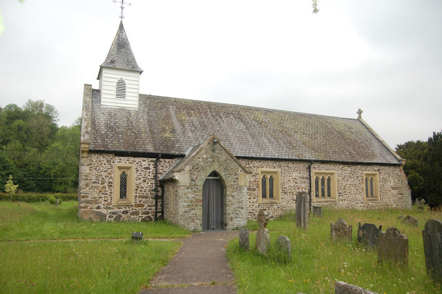


Llanfair Caereinion, United Kingdom
Llanfair Caereinion is a town of 1,055 people in Wales, United Kingdom.
Why visit Llanfair Caereinion
Townapedia lists 5 museums and landmarks, 9 places to eat, 6 places to stay and 6 attractions in and around town.
Highlights include Mathrafal and Rhiw Valley Light Railway.
Weather in Llanfair Caereinion
Forecast from MET Norway (CC BY 4.0). Full forecast
About Llanfair Caereinion
Llanfair Caereinion () is a market town and community in Montgomeryshire, Powys, Wales upon the River Banwy (also known as the River Einion), around 8 miles west of Welshpool. In 2011 the ward had a population of 1,810; the town itself had a population of 1,055 according to Nomis.
From the Wikipedia article Llanfair Caereinion (this version), under CC BY-SA 4.0.
Travel tips from other travellers: Llanfair Caereinion on Wikivoyage (CC BY-SA 4.0).
Things to do6

Museums and landmarks5

Mathrafal
Monument and historic site · 3.2 mi
Castle in Wales, United Kingdom

Tŷ Mawr
Monument and historic site · 4.5 mi
House near Castle Caereinion, Powys, Wales
Restaurants and cafes9


Where to stay6

Neuadd Bridge Static Caravan Park
Campground · 1.4 mi
Only fixed ungalows/cottages here. No RV's, caravans or tents.
History
Its name is a combination of Welsh llan "church" + Mair "Mary" and caer "fort" + Einion, a personal name, meaning "the church of Mary [at] the fort of Einion". The town is built upon the site of an old Roman fort. The site of the Battle of Maes Moydog (1295) is nearby. In 1758 the town was almost completely wiped out by a major fire.
From the History section of Llanfair Caereinion on Wikipedia, under CC BY-SA 4.0.
More about Llanfair Caereinion
Geography
The town is close to Welshpool. It acts as a centre for many scattered hamlets and villages in the area. The electorate of the community places it fourteenth in size, out of the county's eighteen towns. Llanfair Caereinion is classified as an area centre in the Powys Unitary Development Plan, for the market town has the largest range of community services and facilities and the greatest capacity to accommodate additional development in its locality. There are also rural settlements within the community at Heniarth and Melin-y-ddol. The remainder of the population lives in scattered farms and dwellings.
From the Wikipedia article Llanfair Caereinion, under CC BY-SA 4.0.
Notable people from Llanfair Caereinion
 John GriffithsBritish artist, born 1837 (1837–1918)Photo: John Lockwood Kipling, Public domain
 Joseph David JonesWelsh composer and schoolmaster (1827–1870)Photo: William Greatbach, Public domain
- Ryan AstleyWelsh footballer
- Thomas John JehuWelsh geologist
- David DaviesWelsh musician (1810-1875)
Born in Llanfair Caereinion, according to Wikidata (CC0). Each name links to its Wikipedia article.
Churches and places of worship8
Shopping1
Gas and EV charging1
Schools, colleges and libraries3
Map of Llanfair Caereinion
39 places. The map loads OpenStreetMap tiles when you open it.
Getting there and nearby towns
Hawarden Airport (CEG) is the nearest airport with scheduled flights listed in OpenStreetMap, 40 miles away.
- Welshpool 8 mi east, about 12 min by car
- Llanfyllin 8 mi north, about 14 min by car
- Newtown 9 mi south, about 15 min by car
- Pant 14 mi northeast, about 23 min by car
- Llanidloes 16 mi southwest, about 26 min by car
- Bishop's Castle 17 mi southeast, about 28 min by car
- Oswestry 19 mi northeast, about 30 min by car
- Gobowen 21 mi northeast, about 34 min by car
- Whittington 21 mi northeast, about 33 min by car
- Shrewsbury 24 mi east, about 39 min by car
Drive times are estimates from straight-line distance, not routes.
Towns near Llanfair Caereinion


Keep exploring
Local news
Headlines from INDB.
Reviews, tips and questions
Loading what members have shared...
Sources and licences
- GeoNames (CC BY 4.0): population, coordinates, regions and time zone
- Mapillary (see each image): photos
- OpenStreetMap contributors (ODbL 1.0): places, airports, map data
- Wikidata (CC0 1.0): elevation, founding date, time zone, website, landmarks and historic places
- Wikimedia Commons (see each image): photos
- Wikipedia (CC BY-SA 4.0): overview and history text
Photo credits
- Llanfair Caereinion Town Hall, Engraved from a drawing by G Samuel, Public domain
- Mathrafal1, Welshficwitch, CC BY-SA 3.0
- St Michael's Church, Manafon, John Firth, CC BY-SA 2.0
- WLLR 14 sets off, fairlightworks, CC BY 2.0
- St Mary's Church, Llanfair Caereinion, Powys, Wales, Rosser1954, CC BY-SA 4.0
- Countess 2, fairlightworks, CC BY 2.0
- Street-level photo, trigpoint, CC BY-SA 4.0
- Street-level photo, msevilla00, CC BY-SA 4.0
- Street-level photo, msevilla00, CC BY-SA 4.0
- Street-level photo, msevilla00, CC BY-SA 4.0
- Street-level photo, msevilla00, CC BY-SA 4.0
- Street-level photo, msevilla00, CC BY-SA 4.0
- Street-level photo, trigpoint, CC BY-SA 4.0
Page built November 10, 2026. Spotted a mistake? Tell us or suggest a place.