



Oswestry, United Kingdom
Oswestry is a town of 18,743 people in England, United Kingdom.
Why visit Oswestry
Townapedia lists 11 museums and landmarks, 10 parks and trails, 84 places to eat, 5 places to stay and 3 attractions in and around town.
Highlights include Cambrian Railways works, Old Oswestry, Old Oswestry Iron Age Hill Fort and Park Hall Stadium.
Weather in Oswestry
Forecast from MET Norway (CC BY 4.0). Full forecast
About Oswestry
Oswestry ( OZ-wəss-tree; Welsh: Croesoswallt) is an ancient market town, civil parish and historic railway town in Shropshire, England, close to the Welsh border. It is at the junction of the A5, A483 and A495 roads.
From the Wikipedia article Oswestry (this version), under CC BY-SA 4.0.
Travel tips from other travellers: Oswestry on Wikivoyage (CC BY-SA 4.0).
Things to do3

Cambrian Railways works
Bridge
Building in Oswestry, Shropshire, England, UK


Museums and landmarks11

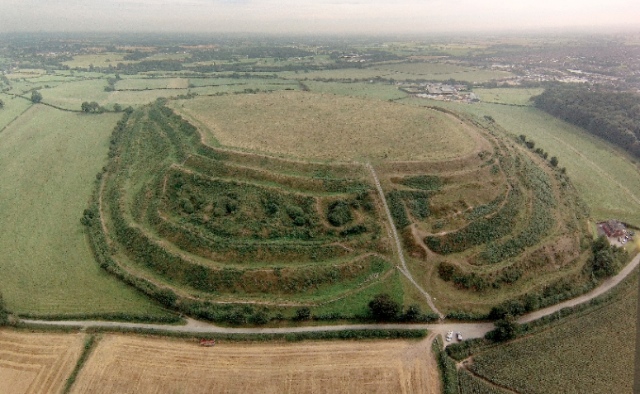
Old Oswestry
Monument and historic site · 0.8 mi
Hillfort in Shropshire, England, UK




Parks, trails and playgrounds10



Restaurants and cafes84




72 more on the map.
History
The earliest known human settlement in Oswestry is Old Oswestry, one of the best-preserved Iron Age hill forts in Britain, with evidence of construction and occupation between 800 BC and 43 AD. The site is known in Welsh as Caer Ogyrfan, meaning 'City of Gogyrfan', referring to the father of Guinevere in Arthurian legend.
The Battle of Maserfield is widely thought to have been fought at Oswestry in 641 or 642, between the Anglo-Saxon kings Penda of Mercia and Oswald of Northumbria. However, the location of the battle is debated among scholars.
The Domesday Book of 1086 records a castle being built by Rainald, a Norman Sheriff of Shropshire: L'oeuvre (French for 'The work').
Alan fitz Flaad (died c.1120), a Breton knight, was granted the feudal barony of Oswestry by King Henry I who, soon after his accession, invited Alan to England with other Breton friends, and gave him forfeited lands in Norfolk and Shropshire, including some which had previously belonged to Ernulf de Hesdin (killed at Antioch while on crusade) and Robert of Bellême.
Read more of the history
Alan's duties to the Crown included supervision of the Welsh border. He also founded Sporle Priory in Norfolk. He married Ada or Adeline, daughter of Ernulf de Hesdin. Their eldest son William FitzAlan was made High Sheriff of Shropshire by King Stephen in 1137. He married a niece of Robert of Gloucester. Alan's younger son, Walter, travelled to Scotland in the train of King David I, Walter becoming the first hereditary Steward of Scotland and ancestor of the Stewart Royal family.
The town changed hands between the English and the Welsh a number of times during the Middle Ages and still retains some Welsh-language street and place names. In 1972, ITV broadcast a television report asking residents if they thought the town should be English or Welsh, with mixed responses.
In 1149 the castle was captured by Madog ap Maredudd during 'The Anarchy', and it remained in Welsh hands until 1157. Sir William Dugdale, writing of Ranulf de Blondeville, 6th Earl of Chester, born c. 1170, explained the surname Blondville (or Blundevill) was an indication of the earl’s birthplace, which he identified as Oswestry, a Shropshire locale adjacent to the border with Powys. Occasionally in the 13th century it is referred to in official records as Blancmuster (1233) or Blancmostre (1272), meaning "White Minster". Later, Oswestry was attacked by the forces of Welsh rebel leader Owain Glyndŵr during the early years of his rebellion against the English King Henry IV in 1400; it became known as Pentrepoeth or "hot village" as it was burned and nearly totally destroyed by the Welsh. The castle was reduced to a pile of rocks during the English Civil War.
The town is now the home of the Shropshire libraries' Welsh Collection.
In 1190 the town was granted the right to hold a market each Wednesday. The town built walls for protection, but these were torn down in the English Civil War by the Parliamentarians after they took the town from the Royalists after a brief siege on 22 June 1644, leaving only the Newgate Pillar visible today.
After the foot and mouth outbreak in the late 1960s the animal market was moved out of the town centre. In the 1990s, a statue of a shepherd and sheep was installed in the market square as a memorial to the history of the market site.
Park Hall, 1-mile (1.6 km) east of the town, was taken over by the Army during World War I in 1915 and used as a training camp and military hospital. On 26 December 1918 it burnt to the ground following an electrical fault. The ruined hall and camp remained derelict between the wars. The camp hospital, however, was still in use; the Baschurch Convalescent and Surgical Home moved there in February 1921 and it became known as the Robert Jones and Agnes Hunt Orthopaedic Hospital.
One of the main uses of the land from the 1920s was for motorcycle racing and it became quite a well-known circuit.
The camp was reactivated in July 1939 for Royal Artillery training and the Plotting Officers' School. Following World War II, Oswestry was a prominent military centre for Canadian troops, then for the British Royal Artillery, and finally a training centre for 15 to 17-year-old Infantry Junior Leaders. The camp closed in 1975. During the 1970s some local licensed wildfowlers discharged their shotguns at some passing ducks and were shot themselves by a young military guard, who had mistaken them for an attacking IRA force.
The area previously occupied by the Park Hall military camp is now mainly residential and agricultural land, with a small number of light industrial units. Park Hall Farm became a visitor attraction in 1998, it is home to the Museum of the Welsh Guards. The Park Hall Football Stadium (home of The New Saints FC) and The Venue is now closed pending redevelopment to enlarge capacity.
From the History section of Oswestry on Wikipedia, under CC BY-SA 4.0.
More about Oswestry
Arts and culture
Fusion Arts organises arts and music activities for young people.
Kinokulture, a cinema (due to close by the end of April 2024)
Oswestry Choral Society, the Oswestry Recorded Music Society, and the Oswestry Ladies Choir has developed.
Borderland Visual Arts. A network of local artists which holds an annual Open Studios event
Education
Oswestry is home to the second oldest 'free' (which in this context means not linked to any ecclesiastical foundation) school in the country, Oswestry School, which was founded in 1407. (The oldest, Winchester College, was founded in 1382). Oswestry School's 15th century site, adjacent to St Oswald's Parish Church, is now a café restaurant. It used to house the Tourist Information Centre, now moved to Castle view.
There are four state primary schools in Oswestry: The Meadows Primary School, Cabin Lane; Woodside Primary School, Gittin Street; Holy Trinity C.E. Primary Academy & Nursery, Beech Grove and Middleton Road; and Our Lady & St. Oswald's Catholic Primary School, Upper Brook Street. There is also an independent co-educational preparatory school in Church Street, Bellan House, which is run by Oswestry School.
Secondary education is provided by both Oswestry School and the state secondary school with academy status: The Marches School, Morda Road.
Further education is provided by The Marches School's Sixth Form and North Shropshire College, which is situated in the town at Shrewsbury Road and at the Walford Campus near Baschurch.
From the Wikipedia article Oswestry, under CC BY-SA 4.0.
Notable people from Oswestry
 Ian HunterBritish rock musician (born 1939)Photo: Jim Summaria, CC BY-SA 3.0
 Jesse ArmstrongBritish comedy and television writerPhoto: Raph_PH, CC BY 2.0
 Matt DoneBritish footballer (born 1988)Photo: Markbarnes, CC BY 2.5
 Francis HumphrysEnglish cricketer, colonial administrator, diplomat (1879-1971)Photo: Photo dept., American Colony (Jerusalem), Public domain
 George Foulkes, Baron Foulkes of CumnockBritish politician (born 1942)Photo: Roger Harris, CC BY 3.0
- Wilfred OwenEnglish Skateboarder 1893-1918)
- Barbara PymBritish writer (1913–1980)
- Ian WoosnamWelsh professional golfer
- Walford DaviesBritish composer (1869–1941)
- Edward WestonUnited States chemist (1850–1936)
- Alexander Macmillan, 2nd Earl of StocktonBritish Conservative politician
- Herbie RobertsEnglish footballer (1905-1944)
Born in Oswestry, according to Wikidata (CC0). Each name links to its Wikipedia article.
Where to stay5
Churches and places of worship17
Shopping24
Gas and EV charging5
Schools, colleges and libraries10
Holy Trinity Church of England Primary Academy and Nursery
School · Anglican · 0.6 mi
Middleton Road, Oswestry
Our Lady and St Oswald's Catholic Primary School
School · Roman Catholic · 0.5 mi
Upper Brook Street, Oswestry
Healthcare3
Map of Oswestry
172 places. The map loads OpenStreetMap tiles when you open it.
Getting there and nearby towns
Hawarden Airport (CEG) is the nearest airport with scheduled flights listed in OpenStreetMap, 22 miles away.
- Whitchurch 17 mi northeast, about 28 min by car
- Wellington 25 mi southeast, about 40 min by car
- Telford 28 mi southeast, about 46 min by car
- Winsford 32 mi northeast, about 51 min by car
- Speke 34 mi north, about 55 min by car
- Sandbach 35 mi northeast, about 56 min by car
- Newcastle under Lyme 36 mi east, about 57 min by car
- Birkenhead 37 mi north, about 59 min by car
- Liverpool 38 mi north, about 1 h by car
- Stoke-on-Trent 38 mi east, about 1 h by car
Drive times are estimates from straight-line distance, not routes.
Towns near Oswestry


Keep exploring
Local news
Headlines from INDB.
Reviews, tips and questions
Loading what members have shared...
Sources and licences
- GeoNames (CC BY 4.0): population, coordinates, regions and time zone
- Mapillary (see each image): photos
- OpenStreetMap contributors (ODbL 1.0): places, airports, map data
- Wikidata (CC0 1.0): elevation, founding date, time zone, website, landmarks and historic places
- Wikimedia Commons (see each image): photos
- Wikipedia (CC BY-SA 4.0): overview and history text
Photo credits
- OswestryMarket, Edward Williams, CC BY-SA 2.0
- Oswestry Castle summit, Verbcatcher, CC BY-SA 4.0
- Oswestry - panoramio (2), Tanya Dedyukhina, CC BY 3.0
- Christ Church, Oswestry (Chapel Street side), Verbcatcher, CC BY-SA 4.0
- Walford Davies plaque Oswestry, Verbcatcher, CC BY-SA 4.0
- Old Oswestry Hillfort (aerial), Oswestry Borderland Tourism, CC BY-SA 2.0
- Church of St Oswald 2013-09-15 13-15-07, Daveyonthemove, CC BY-SA 3.0
- Church of Holy Trinity 1, Rtenny, CC BY-SA 4.0
- A View of the Castle and Part of the Town of Oswestry, in the County of Salop title QS:P1476,en:"A View of the Castle and Part of the Town of Oswestry, in the County of Salop " label QS:Len,"A View..., Peter Toms, CC0
- Cambrian Railways museum with O-6-OST, kitmasterbloke, CC BY 2.0
- Brogyntyn Hall, Oswestry, Row17, CC BY-SA 2.0
- Street-level photo, trigpoint, CC BY-SA 4.0
- Street-level photo, drnoble, CC BY-SA 4.0
- Street-level photo, trigpoint, CC BY-SA 4.0
- Street-level photo, trigpoint, CC BY-SA 4.0
- Street-level photo, trigpoint, CC BY-SA 4.0
- Street-level photo, trigpoint, CC BY-SA 4.0
- Street-level photo, trigpoint, CC BY-SA 4.0
- Street-level photo, trigpoint, CC BY-SA 4.0
- Street-level photo, trigpoint, CC BY-SA 4.0
- Street-level photo, trigpoint, CC BY-SA 4.0
- Street-level photo, trigpoint, CC BY-SA 4.0
- Street-level photo, drnoble, CC BY-SA 4.0


Page built November 10, 2026. Spotted a mistake? Tell us or suggest a place.