


Why visit Marazion
Townapedia lists 8 museums and landmarks, 3 parks and trails, 23 places to eat, 8 places to stay and 1 attraction in and around town.
Highlights include St Michael's Mount Castle, Penlee House Museum and Gallery, Morrab Gardens and The Garden Terraces.
Weather in Marazion
Forecast from MET Norway (CC BY 4.0). Full forecast
About Marazion
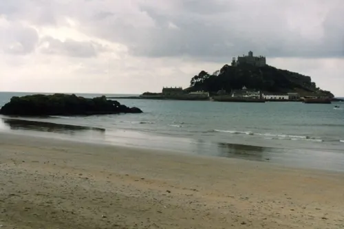
Marazion (; Cornish: Marghasyow [marˈxazjɔʊ] , meaning Thursday market) is a town and civil parish on the shore of Mount's Bay, in Cornwall, England. It lies 2 miles (3.2 km) east of Penzance and the tidal island of St Michael's Mount is half-a-mile offshore. At low water, a causeway links it to the town; at high water, passenger boats carry visitors between Marazion and St Michael's Mount. Marazion is a tourist resort, with an active community of artists who produce and sell paintings and pottery in the town's art galleries.
From the Wikipedia article Marazion (this version), under CC BY-SA 4.0.
Travel tips from other travellers: Marazion on Wikivoyage (CC BY-SA 4.0).
Photos of Marazion


Things to do1

Museums and landmarks8


Penlee House Museum and Gallery
Museum · 3.0 mi
Museum and art gallery in Penzance, Cornwall, England, United Kingdom

Trinity House National Lighthouse Museum
Museum · 3.0 mi
Museum in Cornwall, England


Parks, trails and playgrounds3


Marazion Marsh RSPB Reserve
Park · 0.5 mi
Royal Society for the Protection of Birds (RSPB) reserve west of Marazion, Cornwall, UK
Restaurants and cafes23
The Copper Spoon
Cafe · Sandwich, Ice Cream, Cake, Coffee Shop
Fore Street, Penzance
Sa-Mo 10:00-17:00, We-Th 10:00-17:00


Philps Famous Pasties
Bakery
1 Market Place, Penzance
Mo-Sa 09:00-16:00; Su,PH 10:00-16:00

11 more on the map.
History
Remains of an ancient bronze furnace, discovered near the town, tend to prove that tin smelting was practised here at an early period. Marazion was not recorded in the Domesday Book of 1088.
A late 11th century charter attributed to Robert, Count of Mortain, granted lands and liberties to St Michael's Mount, including the right to hold a market on Thursdays. Although the charter was granted to St Michael's Mount, the market appears to have always been held on the mainland opposite the island. This market appears to be the origin of the name Marazion, coming from Marghasbighan (Parvum Forum, lit. "small marketplace") of the earlier charters and the Marghasyewe (Cornish: "Thursday Market") or Marketjew (Forum Jovis) of the later charters. It may be added that a Jewish origin has been erroneously ascribed to the place from the name Marketjew.
Richard, Earl of Cornwall, granted a further market charter in 1257, which provided that the three fairs, on the two feasts of St Michael and at Mid-Lent, and the three markets which had hitherto been held by the priors of St Michael's Mount on land not their own at Marghasbighan, should in future be held on their own land at Marchadyou. He transferred in fact the fairs and markets from the demesne lands of the Bloyous in Marazion to those of the prior.
Read more of the history
To remedy the loss incurred by this measure, Ralph Bloyou procured for himself and his heirs a market on Mondays and a fair on the vigil, feast, and morrow of St Andrew at Marghasyon in 1331. In Leland's time, the market was held at Marhasdeythyow (Forum Jovis); both Norden (1582) and Carew (1602) tell us that Marcajewe signifies the Thursday's market, which, whether etymologically sound or not, shows that the prior's market had prevailed over its rival.
Marazion was once a flourishing town, owing its prosperity to the throng of pilgrims who came to visit St Michael's Mount, but it largely ceased to be a place of pilgrimage at the Reformation. During the first half of the 16th century, Marazion was twice plundered; first by the French in 1513 and later by Cornish rebels in 1549.
In 1595, Elizabeth I granted Marazion its own charter of incorporation, making it a borough. This ratified the grant of St Andrew's fair, provided for another on the Feast of St Barnabas and established a market on Saturdays. The corporation established by the 1595 charter consisted of a mayor, eight aldermen and twelve capital burgesses. Of the fairs, only the Michaelmas fair has survived and all the markets have gone.
The borough of Marazion briefly served as a constituency during the Commonwealth period in the 1650s, with the right to return two members of parliament. Richard Myll and Thomas Westlake were elected in 1658, but the inhabitants petitioned against them taking their seats because they were unable to pay expenses for their attendance.
The A394 road between Marazion, Helston and Penryn was once run by Helston Turnpike Roads Trust, which charged tolls for using the road. On 1 November 1880, the Trust put the toll houses at Marazion and Wendron up for auction, as well as ″materials″ such as granite posts, chains and gates. The charging of tolls ended on 7 November 1880 and the road came under the management of the County.
The Penwith area, which includes Marazion, was one of the last areas where the Cornish language survived as the vernacular language of the population, but the number of native speakers gradually diminished as the population adopted the English language. A John Nancarrow from Marazion, who survived into the 1790s, was said to be one of the last known native speakers of Cornish.
The West Cornwall Railway opened Marazion railway station on 11 March 1852 and its goods yard handled a large volume of perishable traffic, including fish, fruit, and vegetables, from the surrounding farms and harbours. Marazion station closed to passenger traffic in October 1964 and to freight in December 1965. For many years, the site of the closed station was home to Pullman railway carriages which were used as camping coaches. The site, though not conveniently located, lies on the Cornish Main Line, so there are aspirations to reopen it.
The Royal National Lifeboat Institution opened Marazion Lifeboat Station in 1990, although the D-class (EA16) inshore lifeboat was actually kept in a shed on the quayside on St Michael's Mount. The station was closed on 31 October 2001, as it was proving difficult to find enough volunteer crew members. The boat was transferred to the neighbouring Penlee Lifeboat Station at Newlyn on the other side of Mounts Bay where there is a larger population to draw the crews from.
At the end of the Second World War, a number of naval vessels, including the battleship HMS Warspite, were broken up on the beaches at Marazion. HMS Warspite was beached and broken up in 1947.
In 2021, the town received a brief spike in publicity after submitting itself in a competition for city status held as part of the Platinum Jubilee of Elizabeth II. Marazion subsequently withdrew from the competition after the government decided the bid needed the support of Cornwall Council to proceed, which it did not have.
In March 2026, it was reported that the town had applied to become the first UK Town of Culture in 2028.
From the History section of Marazion on Wikipedia, under CC BY-SA 4.0.
Notable people from Marazion
 Christopher ColeBritish Royal Navy officer (1770–1836)Photo: Margaret Sarah Carpenter (1793-1872), Public domain
 Henry ClutterbuckBritish medical writer 1767-1856Photo: John Cochran / After Henry Room, Public domain
- John JamesManager of the Codrington estate on Barbuda (1772-1826)
Born in Marazion, according to Wikidata (CC0). Each name links to its Wikipedia article.
Where to stay8
Churches and places of worship8
Shopping8
Schools, colleges and libraries2
Healthcare1
Map of Marazion
62 places. The map loads OpenStreetMap tiles when you open it.
Getting there and nearby towns
Land's End Airport (LEQ) is the nearest airport with scheduled flights listed in OpenStreetMap, 9 miles away.
- Penzance 3 mi west, about 4 min by car
- Uny Lelant 4 mi north, about 7 min by car
- Helston 9 mi east, about 15 min by car
- Camborne 10 mi northeast, about 16 min by car
- Redruth 13 mi northeast, about 21 min by car
- Falmouth 18 mi east, about 29 min by car
- Mylor Bridge 18 mi east, about 29 min by car
- Truro 21 mi northeast, about 34 min by car
- Portscatho 22 mi east, about 36 min by car
- Newquay 27 mi northeast, about 43 min by car
Drive times are estimates from straight-line distance, not routes.
Towns near Marazion


Keep exploring
Local news
Headlines from INDB.
Reviews, tips and questions
Loading what members have shared...
Sources and licences
- GeoNames (CC BY 4.0): population, coordinates, regions and time zone
- Mapillary (see each image): photos
- OpenStreetMap contributors (ODbL 1.0): places, airports, map data
- Wikidata (CC0 1.0): elevation, founding date, time zone, website, landmarks and historic places
- Wikimedia Commons (see each image): photos
- Wikipedia (CC BY-SA 4.0): overview and history text
Photo credits
- Marazion, The original uploader was Shropman at English Wikipedia ., CC BY-SA 2.5
- Trelawney Lodge, Marazion, July 2021, Gazamp, CC BY-SA 4.0
- Trelawney Lodge, West End, Marazion, Cornwall - April 2024, Mutney, CC0
- North Street, Marazion, Cornwall - April 2024, Mutney, CC0
- Penlee House 2, Purely Penzance, CC BY 2.0
- Building in Penzance (6329), Nilfanion, CC BY-SA 4.0
- Penzance, Morrab Gardens 01, Palickap, CC BY-SA 3.0
- Penzance - St John's Church (April 2020), Jowaninpensans, CC BY-SA 4.0
- England-Saint-Michaels-Mount-1900-1, Unknown author Unknown author, Public domain
- 2024 Ludgvan Church (03), Chris06, CC BY-SA 4.0
- Ludgvan (2022-07-17) 5, Simon Cobb, CC0
- Marazion (2022-07-16) 111, Simon Cobb, CC0
- Church of All Saints, Marazion - view from NW, Tom Parnell, CC BY-SA 4.0
- Marazion (2022-07-16) 120, Simon Cobb, CC0
- Marazion (2022-07-16) 088, Simon Cobb, CC0
- St Michael's Mount View, Werner Wilmes, CC BY 2.0
- After the squall (24330816514), Philip Male, CC BY 2.0
- Boat car St Michaels Mount Cornwall, Tom Corser, CC BY-SA 3.0
- Street-level photo, WaggyDog, CC BY-SA 4.0
- Street-level photo, live, CC BY-SA 4.0
- Street-level photo, adam2, CC BY-SA 4.0
- Street-level photo, popple, CC BY-SA 4.0
- Street-level photo, themadcabbie, CC BY-SA 4.0
- Street-level photo, adam2, CC BY-SA 4.0
- Street-level photo, live, CC BY-SA 4.0
- Street-level photo, live, CC BY-SA 4.0
- Street-level photo, adam2, CC BY-SA 4.0
- Street-level photo, live, CC BY-SA 4.0
- Street-level photo, WaggyDog, CC BY-SA 4.0
- Street-level photo, adam2, CC BY-SA 4.0
- Street-level photo, adam2, CC BY-SA 4.0
- Street-level photo, live, CC BY-SA 4.0
- Street-level photo, adam2, CC BY-SA 4.0
- Street-level photo, live, CC BY-SA 4.0
- Street-level photo, adam2, CC BY-SA 4.0
- Street-level photo, adam2, CC BY-SA 4.0
- Street-level photo, adam2, CC BY-SA 4.0
- Street-level photo, adam2, CC BY-SA 4.0
- Street-level photo, WaggyDog, CC BY-SA 4.0


Page built November 10, 2026. Spotted a mistake? Tell us or suggest a place.