


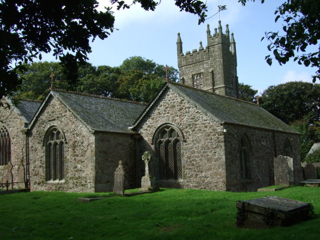


Uny Lelant, United Kingdom
Uny Lelant is a town of 1,056 people in England, United Kingdom.
Why visit Uny Lelant
Townapedia lists 12 museums and landmarks, 12 parks and trails, 41 places to eat, 14 places to stay and 3 attractions in and around town.
Highlights include Porthgwidden Beach, Porthmeor Beach, Leach Pottery and Tate St Ives.
Weather in Uny Lelant
Forecast from MET Norway (CC BY 4.0). Full forecast
About Uny Lelant
Lelant (Cornish: Lannanta) or Uny Lelant is a village in the civil parish of St Ives in, west Cornwall, England, UK. It is on the west side of the Hayle Estuary, about 2+1⁄2 miles (4.0 km) southeast of St Ives and one mile (1.6 km) west of Hayle. The village is part of the Lelant and Carbis Bay ward on Cornwall Council, and also the St Ives Parliamentary constituency. The birth, marriage, and death registration district is Penzance.
From the Wikipedia article Lelant (this version), under CC BY-SA 4.0.
Photos of Uny Lelant


Things to do3

Porthgwidden Beach
Beach · 2.8 mi
Small beach in St Ives, Cornwall, UK


Museums and landmarks12

Leach Pottery
Museum · 2.9 mi
Pottery and museum in St Ives, Cornwall, United Kingdom



Barbara Hepworth Museum and Sculpture Garden
Museum · 2.8 mi
Sculpture museum in Cornwall, England, UK

Parks, trails and playgrounds12





Restaurants and cafes41
Duckies Cafe
Cafe · Regional, Sandwich, Cake, Bistro · 0.9 mi
5 Penpol Terrace, Hayle
Tu-Sa 08:30-16:00; Su 10:00-15:00



29 more on the map.
History
The name is derived from the Cornish lann and Anta, meaning church-site of Anta. The earliest attested spelling is Lananta in about 1170. Nothing is known about Anta, and Lelant parish church is dedicated to St Uny. However, Carbis Bay church is dedicated to St Anta. Arthur Langdon (1896) records eight stone crosses in the parish, of which four are in the churchyard; the other crosses are at Brunian Cairn, Lelant Lane, Sea Lane and the churchtown.
At one time Lelant was an important town and seaport having a market and a custom-house. A parish terrier of 1727 describing the bounds of the glebe land states that about 50 acres of land, and the vicarage, were overwhelmed by sand. The terrier does not give a date but does say that it was not in the living memory of man. In the spring of 1875, during the building of the railway line between St Erth railway station and St Ives, several human skeletons, graves and a building were found by a gang of navvies. Observers of the building thought it was of an ecclesiastical nature, and it is possible that it is the site of a pre-Norman church, burial ground and the former Lelant town. Lelant was formerly an ecclesiastical parish being the mother church of both Towednack and St Ives. The parish church of St Uny's Church, Lelant is at the eastern end of the village on the edge of the towans and overlooking the West Cornwall Golf Club.
Read more of the history
Lelant was a seaport in the Middle Ages, but the trade was lost to St Ives when the estuary silted up. In 1888 the Lelant Quays were offered for let from Lady Day (25 March). They had a water frontage of 574 feet (175 m) and there was a rail link to the St Ives branch line.
At Lower Lelant is a house called The Abbey which was built in the 16th century and renovated in the 18th. In 1831 it was reported that much granite was quarried here, and that there were several tin mines nearby. The family of Praed were landowners here for many centuries. The early 19th century politician and poet Winthrop Mackworth Praed was a member of the family, though he did not live in Cornwall.
On 15 October 1878, the School Board Office of Uny Lelant advertised for tenders for the building of a school to accommodate 234 children. The architect was Silvanus Trevail of Tywardreath. The school, at Trevarrack, 3 kilometres (1.9 mi) west of Lelant, is currently a public house.
The local community radio station is Coast FM (formerly Penwith Radio), which broadcasts on 96.5 and 97.2 FM.\
In 1931 the civil parish of Uny Lelant had a population of 1733. On 1 April 1934 the parish was abolished and merged with St Ives and Ludgvan.
From the History section of Lelant on Wikipedia, under CC BY-SA 4.0.
Notable people from Uny Lelant
 Jim BarnesEnglish-American golferPhoto: Unknown author Unknown author, Public domain
- Rosamunde PilcherBritish novelist (1924–2019)
- Philip ChristophersCanadian politician (1871–1946)
Born in Uny Lelant, according to Wikidata (CC0). Each name links to its Wikipedia article.
Where to stay14
Churches and places of worship17
St Felicitas and St Piala, Phillack Parish Church
Church · Anglican · 1.5 mi
Shopping3
Gas and EV charging2
Schools, colleges and libraries7
Healthcare1
Map of Uny Lelant
112 places. The map loads OpenStreetMap tiles when you open it.
Getting there and nearby towns
Land's End Airport (LEQ) is the nearest airport with scheduled flights listed in OpenStreetMap, 12 miles away.
- Penzance 6 mi southwest, about 10 min by car
- Camborne 7 mi east, about 11 min by car
- Helston 9 mi southeast, about 15 min by car
- Redruth 10 mi east, about 16 min by car
- Falmouth 16 mi east, about 26 min by car
- Truro 18 mi east, about 29 min by car
- Newquay 23 mi northeast, about 37 min by car
- St Austell 31 mi east, about 51 min by car
- Bodmin 37 mi northeast, about 1 h by car
- Saltash 56 mi east, about 1 h 30 min by car
Drive times are estimates from straight-line distance, not routes.
Towns near Uny Lelant


Keep exploring
Local news
Headlines from INDB.
Reviews, tips and questions
Loading what members have shared...
Sources and licences
- GeoNames (CC BY 4.0): population, coordinates, regions and time zone
- Mapillary (see each image): photos
- OpenStreetMap contributors (ODbL 1.0): places, airports, map data
- Wikidata (CC0 1.0): elevation, founding date, time zone, website, landmarks and historic places
- Wikimedia Commons (see each image): photos
- Wikipedia (CC BY-SA 4.0): overview and history text
Photo credits
- The Leach Pottery, St. Ives, Cornwall - Museum Entrance, Jordanhill School D&T Dept, CC BY 2.0
- External tate st ives, flickr user "Steve Parker", CC BY 2.0
- GwinearChurchCornwallUK, Jill Floyd, CC BY-SA 2.0
- St. Ives Parish Church 01, Olaf Tausch, CC BY 3.0
- Lelantchurch2, waterborough, Public domain
- The Bucket Of Blood in Phillack, Cornwall, M16995, CC BY-SA 3.0
- Cornubia Inn, Hayle, Cornwall - January 2022 (2), Mutney, CC BY-SA 4.0
- Eastleigh. Fore Street, Lelant, Cornwall - July 2022, Mutney, CC BY-SA 4.0
- Houses and the Village Hall, Fore Street, Lelant, Cornwall - July 2022, Mutney, CC BY-SA 4.0
- Lelant Village Hall (front view), Fore Street, Lelant Cornwall - July 2022, Mutney, CC BY-SA 4.0
- A3074 Fore Street, Lelant, Cornwall - July 2022 (1), Mutney, CC BY-SA 4.0
- East View, Fore Street, Lelant, Cornwall - July 2022, Mutney, CC BY-SA 4.0
- Lelant Village Hall, Fore Street, Lelant, Cornwall - 2022, Mutney, CC BY-SA 4.0
- East View door, Fore Street, Lelant, Cornwall - July 2022, Mutney, CC BY-SA 4.0
- Trecott, Fore Street, Lelant, Cornwall - July 2022, Mutney, CC BY-SA 4.0
- Post box, Fore Street, Lelant, Cornwall - July 2022, Mutney, CC BY-SA 4.0
- Post Box and bus stop. Fore Street, Lelant, Cornwall - July 2022, Mutney, CC BY-SA 4.0
- Ninevah, Fore Street, Lelant, cornwall - July 2022, Mutney, CC BY-SA 4.0
- Rose Cottage, Fore Street, Lelant, Cornwall - July 2022, Mutney, CC BY-SA 4.0
- Ninevah and Strawberry Lane, Fore Street, Lelant, cornwall - July 2022, Mutney, CC BY-SA 4.0
- Cedar House, Fore Street, Lelant, Cornwall - July 2022, Mutney, CC BY-SA 4.0
- A3074 Fore Street, Lelant, Cornwall - July 2022 (2), Mutney, CC BY-SA 4.0
- Detatched house and garage, Vicarage Lane, Lelant, Cornwall - July 2022, Mutney, CC BY-SA 4.0
- Aukland, Avalon and Gable Cottage, Fore Street, Lelant, Cornwall - July 2022, Mutney, CC BY-SA 4.0
- Chilecito Villas, Fore Street, Lelant, Cornwall - July 2022, Mutney, CC BY-SA 4.0
- Cedar Court, Fore Street, Lelant, Cornwall - July 2022, Mutney, CC BY-SA 4.0
- Houses on Fore Street, Lelant Cornwall - July 2022 (1), Mutney, CC BY-SA 4.0
- The Badger Inn, Fore Street, Lelant, Cornwall - July 2022 (4), Mutney, CC BY-SA 4.0
- The Badger Inn, Fore Street, Lelant, Cornwall - July 2022 (3), Mutney, CC BY-SA 4.0
- The Badger Inn, Fore Street, Lelant, Cornwall - July 2022 (2), Mutney, CC BY-SA 4.0
- Listed buildings on Tyringham Road, Lelant, Cornwall - July 2022, Mutney, CC BY-SA 4.0
- War Memorial, Lelant, Cornwall - July 2022 (2), Mutney, CC BY-SA 4.0
- Crossways, Tyringham Road, Lelant, Cornwall - July 2022, Mutney, CC BY-SA 4.0
- Lelant War Memorial. - panoramio, dennis white, CC BY-SA 3.0
- War Memorial, Lelant, Cornwall - July 2022 (1), Mutney, CC BY-SA 4.0
- Roseleigh, Tyringham Road, Lelant, Cornwall - July 2022, Mutney, CC BY-SA 4.0
- Pax and Crossways, Tyringham Road, Lelant, Cornwall - July 2022, Mutney, CC BY-SA 4.0
- Wheal Vor, Tyringham Road, Lelant, Cornwall - July 2022 (2), Mutney, CC BY-SA 4.0
- Myrtle Cottage, Tyringham Road, Lelant, Cornwall - July 2022, Mutney, CC BY-SA 4.0
- Porthgwidden-Beach, Gazamp, CC BY-SA 4.0
- Porthmeor Beach St. Ives from air Fossick, Fossick OU, CC BY-SA 3.0
- Toilet block, Porthminster Beach, St Ives, Gazamp, CC BY-SA 4.0
- Rick Rescorla Memorial, Hayle, Cornwall, Ben Darlow, CC BY-SA 3.0
- Sunrise at Carbis Bay Beach, Cornwall. Holder Of The G7 Summit In 2021. (Creative Commons by www.hedgehogdigital.co.uk). (50976430988), Hedgehog Digital, CC BY 2.0
- Street-level photo, WaggyDog, CC BY-SA 4.0
- Street-level photo, livingwithdragons, CC BY-SA 4.0
- Street-level photo, WaggyDog, CC BY-SA 4.0
- Street-level photo, WaggyDog, CC BY-SA 4.0
- Street-level photo, adam2, CC BY-SA 4.0
- Street-level photo, WaggyDog, CC BY-SA 4.0
- Street-level photo, WaggyDog, CC BY-SA 4.0
- Street-level photo, WaggyDog, CC BY-SA 4.0
- Street-level photo, WaggyDog, CC BY-SA 4.0
- Street-level photo, WaggyDog, CC BY-SA 4.0
- Street-level photo, WaggyDog, CC BY-SA 4.0
- Street-level photo, WaggyDog, CC BY-SA 4.0
- Street-level photo, WaggyDog, CC BY-SA 4.0
- Street-level photo, ebel, CC BY-SA 4.0
- Street-level photo, adam2, CC BY-SA 4.0
- Street-level photo, adam2, CC BY-SA 4.0
- Street-level photo, livingwithdragons, CC BY-SA 4.0
- Street-level photo, WaggyDog, CC BY-SA 4.0
- Street-level photo, WaggyDog, CC BY-SA 4.0
- Street-level photo, WaggyDog, CC BY-SA 4.0
- Street-level photo, livingwithdragons, CC BY-SA 4.0
- Street-level photo, adam2, CC BY-SA 4.0
- Street-level photo, WaggyDog, CC BY-SA 4.0


Page built November 10, 2026. Spotted a mistake? Tell us or suggest a place.