
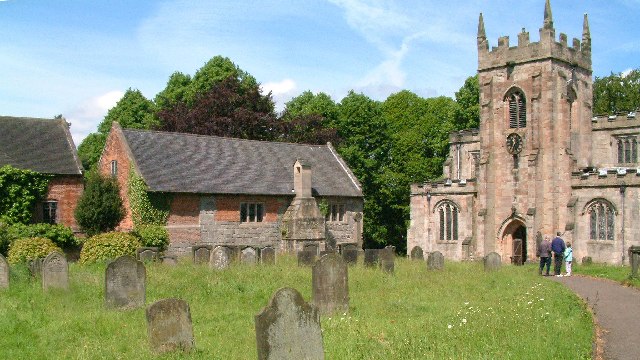


Why visit Mayfield
Townapedia lists 3 museums and landmarks, 3 parks and trails, 5 places to eat and 3 places to stay in and around town.
Highlights include Norbury Manor, Thorswood and Ashbourne Golf Club.
Weather in Mayfield
Forecast from MET Norway (CC BY 4.0). Full forecast
About Mayfield
Mayfield is a village on the outskirts of Ashbourne in Derbyshire, about 9 miles from Uttoxeter, situated in East Staffordshire.
From the Wikipedia article Mayfield, Staffordshire (this version), under CC BY-SA 4.0.
Museums and landmarks3

Norbury Manor
Museum · 2.7 mi
Grade I listed historic house museum in Derbyshire Dales, United Kingdom

Parks, trails and playgrounds3



Restaurants and cafes5



Where to stay3


History
Mayfield was mentioned in the Domesday Book, in which it was called 'Mavreveldt'. The surname likely derives from Old English mæþel "speech, assembly, meeting" and feld "field".
It was the scene of a siege during the retreat of Bonnie Prince Charlie, whose followers terrorised the local villagers forcing them to take refuge in John the Baptist's church. Several musket ball holes, reputedly from weapons fired during the siege, can still be seen in one of the doors of the church.
There has been a church in Mayfield for over a thousand years. The Domesday Survey of 1086 recorded a priest in Mayfield, one of only twenty-five priests recorded for the county of Staffordshire. There is now no trace of the original Church, which would have been a Saxon wooden building standing on or near to the site of the present church. The Saxon church was replaced during the reign of Henry I by a Norman stone building in about 1125. The church was extended in the 15 and 16th Centuries, with the tower being built in 1515. The final extension was in 1854.
On 13 June 1944 a Royal Air Force Vickers Wellington (LP397) from RAF Castle Donington was on a cross country exercise. 25 minutes later the aircraft entered a thuderstorm shortly after the aircraft went into a nose dive & crashed near the village. All Six of the bomber crew died in the crash.
From the History section of Mayfield, Staffordshire on Wikipedia, under CC BY-SA 4.0.
More about Mayfield
Economy
Mayfield's mill, in one form or another, has been standing on the banks of the Dove since the 12th Century. Today Mayfield Yarns produces warped and twisted yarns. The parish is also home to several farms.
From the Wikipedia article Mayfield, Staffordshire, under CC BY-SA 4.0.
Notable people from Mayfield
- Bertram Coghill Alan WindleBritish anatomist, administrator, archaeologist, scientist, educationalist and writer (1858-1929)
Born in Mayfield, according to Wikidata (CC0). Each name links to its Wikipedia article.
Churches and places of worship11
St Peters Parish Church Snelston
Church · Anglican · 0.9 mi
Church Lane, Ashbourne
Shopping3
Gas and EV charging1
Schools, colleges and libraries2
Healthcare2
Map of Mayfield
33 places. The map loads OpenStreetMap tiles when you open it.
Getting there and nearby towns
East Midlands Airport (EMA) is the nearest airport with scheduled flights listed in OpenStreetMap, 22 miles away.
- Uttoxeter 8 mi southwest, about 13 min by car
- Cheadle 9 mi west, about 15 min by car
- Belper 12 mi east, about 19 min by car
- Derby 13 mi southeast, about 21 min by car
- Leek 13 mi northwest, about 21 min by car
- Matlock 13 mi northeast, about 21 min by car
- Burton upon Trent 14 mi south, about 23 min by car
- Sinfin 14 mi southeast, about 23 min by car
- Longton 15 mi west, about 25 min by car
- Chaddesden 15 mi east, about 24 min by car
Drive times are estimates from straight-line distance, not routes.
Towns near Mayfield


Keep exploring
Local news
Headlines from INDB.
Reviews, tips and questions
Loading what members have shared...
Sources and licences
- GeoNames (CC BY 4.0): population, coordinates, regions and time zone
- Mapillary (see each image): photos
- OpenStreetMap contributors (ODbL 1.0): places, airports, map data
- Wikidata (CC0 1.0): elevation, founding date, time zone, website, landmarks and historic places
- Wikimedia Commons (see each image): photos
- Wikipedia (CC BY-SA 4.0): overview and history text
Photo credits
- Norbury church and hall 046773 50c8b955, Alan Walker, CC BY-SA 2.0
- Thorswood path, AtticTapestry, CC BY-SA 4.0
- Saint James Church, Edlaston in Derbyshire, Eamon Curry, CC BY 2.0
- St. Martin's Church, Osmaston 06, Simon Burchell, CC BY-SA 4.0
- Norbury Church Derbyshire, Alan Walker, CC BY-SA 2.0
- Snelston5, Andrewrabbott ( talk ), Public domain
- Holy Trinity Church, Clifton, Chris Morgan, CC BY-SA 2.0
- Royal Oak near Ashbourne, Dave.Dunford, CC BY-SA 4.0
- Street-level photo, edloach, CC BY-SA 4.0
- Street-level photo, southglos, CC BY-SA 4.0
- Street-level photo, southglos, CC BY-SA 4.0

Page built November 10, 2026. Spotted a mistake? Tell us or suggest a place.