


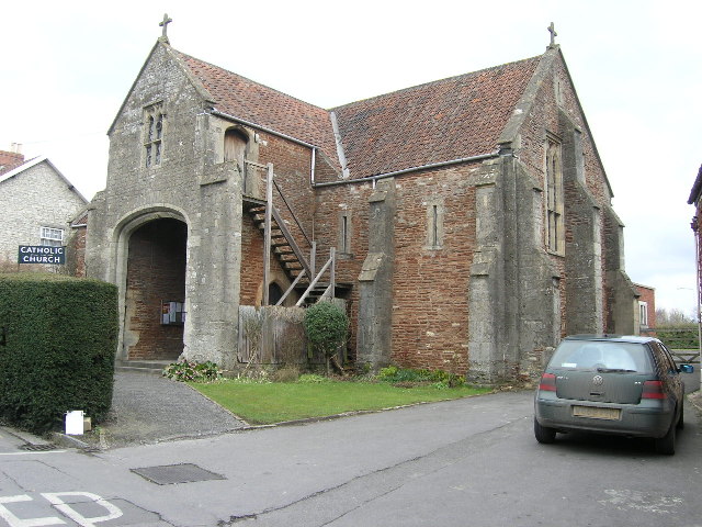


Midsomer Norton, United Kingdom
Midsomer Norton is a town of 13,000 people in England, United Kingdom.
Why visit Midsomer Norton
Townapedia lists 2 museums and landmarks, 4 parks and trails, 47 places to eat, 4 places to stay and 2 attractions in and around town.
Highlights include Radstock Museum and Stephen's Vale Nature Reserve.
Weather in Midsomer Norton
Forecast from MET Norway (CC BY 4.0). Full forecast
About Midsomer Norton
Midsomer Norton is a town near the Mendip Hills in Bath and North East Somerset, England. It lies 10 miles (16 km) south-west of Bath, 10 miles (16 km) north-east of Wells, 10 miles (16 km) north-west of Frome, 12 miles (19 km) west of Trowbridge and 16 miles (26 km) south-east of Bristol. At the 2021 census, the parish had a population of 12,197, and the built-up area as defined by the Office for National Statistics, which extends into the neighbouring parish of Westfield, had a population of 13,745. The town closely adjoins neighbouring Radstock.
From the Wikipedia article Midsomer Norton (this version), under CC BY-SA 4.0.
Photos of Midsomer Norton


Things to do2

Museums and landmarks2

Radstock Museum
Museum · 1.7 mi
Museum in Radstock, Somerset, United Kingdom

Double Hills Memorial
Monument and historic site · 1.4 mi
Commemorates the 23 lives lost when a glider crashed on 17 September 1944. The glider was part of Operation Market Garden.
Parks, trails and playgrounds4

Stephen's Vale Nature Reserve
Park · 2.8 mi
Nature reserve in Somerset, England



Restaurants and cafes47






35 more on the map.
History
"Norton" means 'northish enclosure' from the Old English, while the use of its forename to distinguish it from other 'Nortons' is of late origin and not mentioned until 1334. Sources point to the town being situated midway between two branches of the River Somer; the Somer itself and Wellow Brook, which joins the Somer a short distance to the east near Radstock.
Eilert Ekwall wrote that the village "is said to be so called in allusion to the festival held at midsummer on the day of St. John, the patron saint."
John Wesley wrote of the appalling local road conditions which ensured it was reachable "only in midsummer." As Simon Winchester notes in his book The Map that Changed the World, "...the roads on this part of Somerset were atrocious, thick with mud and as rough as the surface of the moon".
In some church records the town is referred to as 'Norton Canonicorum' as an alternative to Midsomer Norton, and this may be because of the local Priory's link to Merton Priory in London until the dissolution of the monasteries in 1538.
The area at what is now Langley’s Lane in Midsomer Norton was an important and rare area of Mesolithic activity focused around an
The Fosse Way runs through the south-western edge of the town between Westfield, Somerset and Stratton-on-the-Fosse.
Read more of the history
Following the Norman Conquest William the Conqueror gave large parts of north Somerset, including the manor of Norton to Geoffrey de Montbray, bishop of Coutances, and Norton was held under him by Ulveva. From about 1150 until 1300 the manor was held by Alured de Lincoln. From 1387 the manor was held by the family of Thomas West, 1st Baron West and his descendants.
The Duchy of Cornwall owned most of the mineral rights around Midsomer Norton and various small pits opened around 1750 to exploit these. Coal mining in the Somerset coalfield gave the town and area its impetus as an industrial centre.
Around 1866 an obelisk Crimean War monument with two marble plaques, was built at the site of St Chad's well, by the mother of Frederick Stukeley Savage for the benefit of the poor. The obelisk was in the grounds of Norton House, a Georgian mansion built by Thomas Savage, an investor in coalmines in the area, in 1789. The house itself has since been demolished but other features of its estate are still visible at Silver Street Nature reserve (see below).
From the History section of Midsomer Norton on Wikipedia, under CC BY-SA 4.0.
More about Midsomer Norton
Geography
The main geological feature in this area of the Mendip Hills south of Hallatrow consists of Supra-Pennant Measures which includes the upper coal measures and outcrops of sandstone. The relics of the industrial past are very evident within the area, including the distinct conical shape of the Old Mills batch overlooking the town.
Midsomer Norton lies on the River Somer which rises to the west of Chilcompton and on the Wellow Brook which rises near the village of Ston Easton. The town therefore occupies two valleys of the Mendip Hills and these merge west of Radstock. The combined river then flows east reaching the River Avon near Midford, thence to Bath and through Bristol into the Bristol Channel at Avonmouth.
On the southern fringes of the town is the 2 hectares (4.9 acres) Silver Street Local Nature Reserve, on the site of the estate of Norton House, an eighteenth century mansion built by the coalmine-owning Savage family but demolished in 1937-8. It contains a broad-leaf woodland around several ponds, a restored nineteenth-century wellhead that supplied water to the house, and a grassland field. The woodland is leased to the Somerset and Dorset Heritage Railway Trust by Bath and North East Somerset Council and the meadow in the stewardship of Somervale School.
Arts and culture
Midsomer Norton's railway station was mentioned in Slow Train by Michael Flanders and Donald Swann:
Children's author Roald Dahl sold kerosene in Midsomer Norton and the surrounding area in the 1930s. He described the experience in his autobiographical work Boy: Tales of Childhood (published 1984):
My kerosene motor-tanker had a tap at the back and when I rolled into Shepton Mallet or Midsomer Norton or Peasedown St John or Huish Champflower, the old girls and the young maidens would hear the roar of my motor and would come out of their cottages with jugs and buckets to buy a gallon of kerosene for their lamps and their heaters. It is fun for a young man to do that sort of thing. Nobody gets a nervous breakdown or a heart attack from selling kerosene to gentle country folk from the back of a tanker in Somerset on a fine summer’s day.
Education
First schools for children up to 11 include Midsomer Norton Primary, St. John's Church of England, Welton Primary, Longvernal Primary, Westfield Primary and Norton Hill Primary. In addition, St Benedict's Catholic Primary School on the edge of Midsomer Norton with a 'Midsomer Norton, Radstock' postal address, is actually part of the neighbouring Somerset Council's education service.
There are two local secondary schools. Norton Hill School has approximately 1,400 students from the age of 11 to 18. In 1999, it became a Technology College and in 2007 changed specialism to become a Maths and Computing College. In 2006, Norton Hill was also awarded a second specialism as a Language College. The school was described by Ofsted in 2007 as outstanding in every respect. The school has received both the Sportsmark Award by Sport England and Artsmark Silver Award. Somervale School which has foundation status, is a specialist Arts College. In 2008, the school was the first in Bath and North East Somerset to win the Eco-Schools Silver Award. The number of pupils on the school roll had fallen to 603. This fall prompted the school to propose a federation with nearby Norton Hill School in March 2009 called the Midsomer Norton Schools Partnership. This is now in place with Alun Williams as the overall head teacher of both schools within the federation.
From the Wikipedia article Midsomer Norton, under CC BY-SA 4.0.
Notable people from Midsomer Norton
 Anita HarrisBritish singer and actress (1942)Photo: SteVader, CC BY 3.0
- Duncan SteelBritish astronomer
- Joan BeauchampBritish communist
- Kay BeauchampBritish activist (1899-1992)
- Thomas William AlliesEnglish historian (1813-1903)
- Don CarterEnglish footballer (1921-2002)
- Arthur WaughBritish author
- Bert HeadEnglish association footballer, manager and coach (1916-2002)
- C. J. F. WilliamsBritish logician (1930-1997)
- Elizabeth Hallam-SmithEnglish librarian, information professional and historian
- Chloe DaviesParalympic swimmer
- William BeesEnglish soldier (1871–1938); recipient of the Victoria Cross
Born in Midsomer Norton, according to Wikidata (CC0). Each name links to its Wikipedia article.
Where to stay4
Churches and places of worship23
Shopping7
Gas and EV charging4
Schools, colleges and libraries13
Healthcare4
Map of Midsomer Norton
111 places. The map loads OpenStreetMap tiles when you open it.
Getting there and nearby towns
Bristol Airport (BRS) is the nearest airport with scheduled flights listed in OpenStreetMap, 12 miles away.
- Midsomer Norton map
- Shepton Mallet 7 mi south, about 11 min by car
- Bath 8 mi northeast, about 13 min by car
- Wells 9 mi southwest, about 14 min by car
- Bristol 13 mi north, about 20 min by car
- Westbury 13 mi east, about 21 min by car
- Warminster 14 mi southeast, about 23 min by car
- Nailsea 16 mi northwest, about 25 min by car
- Street 16 mi southwest, about 25 min by car
- Stoke Gifford 16 mi north, about 26 min by car
- Yatton 16 mi northwest, about 26 min by car
Drive times are estimates from straight-line distance, not routes.
Towns near Midsomer Norton


Keep exploring
Local news
Headlines from INDB.
Reviews, tips and questions
Loading what members have shared...
Sources and licences
- GeoNames (CC BY 4.0): population, coordinates, regions and time zone
- Mapillary (see each image): photos
- OpenStreetMap contributors (ODbL 1.0): places, airports, map data
- Wikidata (CC0 1.0): elevation, founding date, time zone, website, landmarks and historic places
- Wikimedia Commons (see each image): photos
- Wikipedia (CC BY-SA 4.0): overview and history text
Photo credits
- Midsomer Norton Town Hall, Nigel Shoosmith, CC BY-SA 2.0
- Midsomer Norton Church (St. John the Baptist) (49634564833), Hugh Llewelyn from Keynsham, UK, CC BY-SA 2.0
- Church of the Holy Ghost, Midsomer Norton, ChurchCrawler, CC BY-SA 2.0
- Midsomer Norton Church (St. John the Baptist) (49635086731), Hugh Llewelyn from Keynsham, UK, CC BY-SA 2.0
- Midsomer Norton RC Church (Holy Ghost) (49635087186), Hugh Llewelyn from Keynsham, UK, CC BY-SA 2.0
- Midsomer Norton RC Church (Holy Ghost) (49635362172), Hugh Llewelyn from Keynsham, UK, CC BY-SA 2.0
- Midsomer Norton Priory (49635086541), Hugh Llewelyn from Keynsham, UK, CC BY-SA 2.0
- Church of the Holy Ghost - Catholic church in Midsomer Norton, Somerset 1, Artur Kozioł, CC BY-SA 3.0
- Church of the Holy Ghost - Catholic church in Midsomer Norton, Somerset 2, Artur Kozioł, CC BY-SA 3.0
- Ston Easton church, Dr Duncan Pepper, CC BY-SA 2.0
- St Vigors church, Stratton-on-the-Fosse, Jonathan Billinger, CC BY-SA 2.0
- Holcombe Old St Andrews church, ChurchCrawler, CC BY-SA 2.0
- Paulton church, Rodw at English Wikipedia Rod Ward, Public domain
- Norton Hill School, Rodw, CC0
- Paulton hospital, Rodw, Public domain
- Somervale School, Rodw, CC0
- St. John the Baptist Church - panoramio, Artur Kozioł, CC BY-SA 3.0
- St. John the Baptist Church - panoramio (1), Artur Kozioł, CC BY-SA 3.0
- PaultonBatch, Stuz at English Wikipedia, CC BY-SA 3.0
- Street-level photo, southglos, CC BY-SA 4.0
- Street-level photo, southglos, CC BY-SA 4.0
- Street-level photo, southglos2, CC BY-SA 4.0
- Street-level photo, southglos2, CC BY-SA 4.0
- Street-level photo, southglos, CC BY-SA 4.0
- Street-level photo, southglos, CC BY-SA 4.0
- Street-level photo, southglos2, CC BY-SA 4.0
- Street-level photo, southglos2, CC BY-SA 4.0
- Street-level photo, southglos, CC BY-SA 4.0
- Street-level photo, southglos, CC BY-SA 4.0
- Street-level photo, southglos2, CC BY-SA 4.0
- Street-level photo, southglos, CC BY-SA 4.0
- Street-level photo, southglos, CC BY-SA 4.0
- Street-level photo, southglos, CC BY-SA 4.0


Page built November 10, 2026. Spotted a mistake? Tell us or suggest a place.