


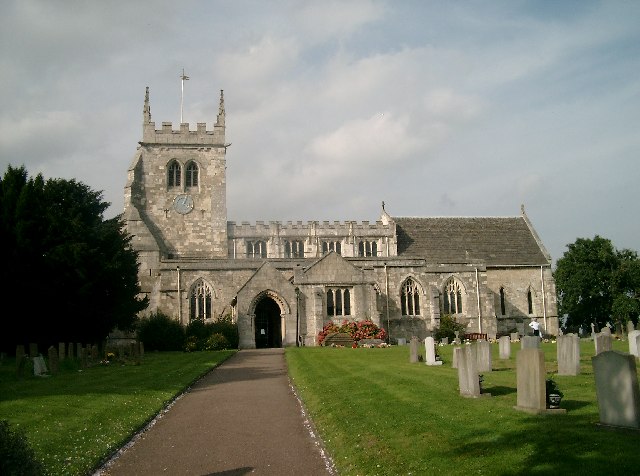


Monk Fryston, United Kingdom
Monk Fryston is a town of 1,728 people in England, United Kingdom.
Why visit Monk Fryston
Townapedia lists 1 museum or landmark, 1 park or trail, 4 places to eat, 1 place to stay and 2 attractions in and around town.
Highlights include Ferry Bridge, Burton Salmon War Memorial and South Milford Park.
Weather in Monk Fryston
Forecast from MET Norway (CC BY 4.0). Full forecast
About Monk Fryston
Monk Fryston is a small village and civil parish in the county of North Yorkshire, England.
From the Wikipedia article Monk Fryston (this version), under CC BY-SA 4.0.
Things to do2
Ferry Bridge
Bridge · 3.4 mi
Grade I listed bridge in Ferrybridge, West Yorkshire, England

Museums and landmarks1

Parks, trails and playgrounds1

Restaurants and cafes4


History
The Dictionary of British Place Names notes Monk Fryston as "Fristun" (c. 1030) and "Munechesfryston" (1166). The name derives from the Old English for "farmstead of the frisians", with prefix 'Monk' relating to it being an 11th-century possession of Selby Abbey. According to a personal FreeUK web page, the name of the village originates from Monk's Free Stone, as all of the stone used to build Selby Abbey was obtained from a quarry in the centre of the village across the road from the old school building. The quarry was filled in for a housing development located next to the new school building, built on the old school field in 1998–99. The old school building has since been converted to housing.
The village is very closely linked to Hillam, although both villages maintain separate parish councils.
According to the 2011 UK census the population of Monk Fryston parish was 1,008 and the number of households was 406.
Monk Fryston is situated just over 6 miles (10 km) west of the town of Selby. It lies 2 miles (3 km) east of the A1(M) motorway junction 42, (A1 road), and 5 miles (8 km) north of the M62 motorway, junction 33, at Ferrybridge. The A63 road, Leeds to Selby, runs through the village.
Primary education needs are served by Monk Fryston Church of England Primary School.
St Wilfrid's Church, Monk Fryston is the Church of England parish church
Read more of the history
The village has one public house, the Crown Inn, which dates back to the 1600s, and a hotel, the Monk Fryston Hall Hotel which dates back to the 12th century.
The National Heritage List for England, compiled by English Heritage, holds 15 listed buildings for Monk Fryston. The list includes the Grade I St Wilfrid's Church, the Grade II* Monk Fryston Hall and two Grade II milestones.
The York and North Midland Railway passes to the west of Monk Fryston. An old station platform still exists next to the railway just down from Milford sidings. The spot is popular with railway enthusiasts.
Monk Fryston is the namesake for many sports around the village, including cricket and football. Despite this, the home games of the football and cricket teams are held in Stocking Lane, which is in Hillam.
From the History section of Monk Fryston on Wikipedia, under CC BY-SA 4.0.
Notable people from Monk Fryston
 Joe Wrightassociation football playerPhoto: Bradford City AFC, CC BY 3.0
- John OvertonChurch of England clergyman and evangelical apologist
- Joe AndersonEnglish rugby league footballer
Born in Monk Fryston, according to Wikidata (CC0). Each name links to its Wikipedia article.
Where to stay1
Churches and places of worship10
Gas and EV charging1
Schools, colleges and libraries2
Healthcare1
Map of Monk Fryston
23 places. The map loads OpenStreetMap tiles when you open it.
Getting there and nearby towns
Leeds Bradford Airport (LBA) is the nearest airport with scheduled flights listed in OpenStreetMap, 19 miles away.
- Knottingley 4 mi south, about 6 min by car
- Kippax 5 mi west, about 9 min by car
- Castleford 6 mi southwest, about 9 min by car
- Pontefract 6 mi southwest, about 9 min by car
- Garforth 6 mi west, about 10 min by car
- Selby 7 mi east, about 11 min by car
- Featherstone 8 mi southwest, about 12 min by car
- Lofthouse 11 mi west, about 17 min by car
- Wakefield 12 mi southwest, about 19 min by car
- Leeds 13 mi west, about 21 min by car
Drive times are estimates from straight-line distance, not routes.
Towns near Monk Fryston


Keep exploring
Local news
Headlines from INDB.
Reviews, tips and questions
Loading what members have shared...
Sources and licences
- GeoNames (CC BY 4.0): population, coordinates, regions and time zone
- Mapillary (see each image): photos
- OpenStreetMap contributors (ODbL 1.0): places, airports, map data
- Wikidata (CC0 1.0): elevation, founding date, time zone, website, landmarks and historic places
- Wikimedia Commons (see each image): photos
- Wikipedia (CC BY-SA 4.0): overview and history text
Photo credits
- Malvern House, Monk Fryston (8051380479), Tim Green from Bradford, CC BY 2.0
- Blue Ball, Monk Fryston (closed) (8039920273), Tim Green from Bradford, CC BY 2.0
- All Saints Church, Sherburn in Elmet, John Davidson, CC BY-SA 2.0
- Methodist Chapel, Monk Fryston (former) (8048130815), Tim Green from Bradford, CC BY 2.0
- War Memorial, Burton Salmon, Alan Murray-Rust, CC BY-SA 2.0
- Street-level photo, humez, CC BY-SA 4.0
Page built November 10, 2026. Spotted a mistake? Tell us or suggest a place.