


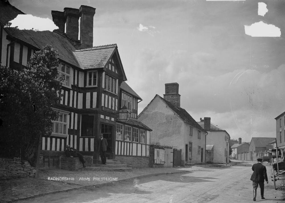
Presteigne, United Kingdom
Presteigne is a town of 2,056 people in Wales, United Kingdom.
Why visit Presteigne
Townapedia lists 3 museums and landmarks, 7 parks and trails, 11 places to eat and 3 places to stay in and around town.
Highlights include The Judge's Lodging, Shire Hall and Titley Pool.
Weather in Presteigne
Forecast from MET Norway (CC BY 4.0). Full forecast
About Presteigne
Presteigne (; Welsh: Llanandras: the church of St Andrew) is a town and community on the south bank of the River Lugg in Powys, Wales. The town is located on the England–Wales border, which surrounds it to the north, east and south. Nearby towns are Kington, Herefordshire to the south and Knighton to the north, and surrounding villages include Norton (within the community) and Stapleton. The community has a population of 2,710; the built-up area had a population of 2,056.
From the Wikipedia article Presteigne (this version), under CC BY-SA 4.0.
Travel tips from other travellers: Presteigne on Wikivoyage (CC BY-SA 4.0).
Museums and landmarks3


Parks, trails and playgrounds7



Restaurants and cafes11

The Farmers Inn
Bar and pub
1 Hereford Street, Presteigne
Tu,We 15:00-20:00; Th 15:00-22:00; Fr 15:00+; Sa 12:00+; Su 14:00-22:00

Daphne's
Restaurant · Pizza
53 High Street, Presteigne
Th,Fr 17:00-22:00; Su 17:00-21:00


Lorna's Sandwich Shop
Fast food
48 High Street, Presteigne
Mo-Fr 08:00-14:00; Sa,Su off
Where to stay3


History
The town probably began as a small settlement around a minster church dedicated to St Andrew and at the time of the Domesday Book it formed part of the manor of Humet.
By the mid-12th century, it was known as 'Presthemede' or 'the bordering meadow of the priests'. A century later, it passed into the control of the Mortimers, powerful Marcher lords, and on their fall passed into the hands of the Crown.
At the end of the 13th century, the majority of the town's inhabitants, mainly English, enjoyed some prosperity but the Black Death and the Glyndŵr rebellion had destroyed this and by the end of the 15th century, the now largely Welsh, population lived in a struggling village. A significant victory in their rebellion was won by the forces of Owain Glyndŵr nearby at the Battle of Bryn Glas in 1402.
The development of a thriving cloth industry in the Tudor period brought short-lived prosperity, ended by three new epidemics of plague in three successive generations. Thereafter it became a market town and, until the later 16th century, a centre for processing locally grown barley into malt.
By the Acts of Union, Presteigne - at first jointly with New Radnor - became the county town of Radnorshire and its administrative and judicial centre, housing the county gaol and the Shire Hall.
Read more of the history
By the end of the 19th century, its newer and larger neighbour, Llandrindod Wells, had usurped the role of administrative centre, but Presteigne remained the venue for the Assizes until these were abolished in 1971.
After a period of stagnation in the first half of the 20th century, the town has developed a diverse manufacturing base and has begun to exploit its tourism potential while its environment and the development of its social, cultural and leisure facilities have helped to attract people to settle.
Presteigne attracted national attention in 2004 for an unsuccessful campaign by its Mayor, Councillor Peggy Fraser-Scott, to enforce a curfew on the town's youth.
Henry Edward's Old English Customs: Curious Requests and Charities mentions the bell ringer appointed by John Beddoes in 1565 to ring a "day bell" at 8am, and a curfew at 8pm. Beddoes specified that in the event of the custom being abandoned for more than a year, (except in plagues) the funds set aside for this position would revert to his heirs.
Beddoes, a wool merchant, gave his name to Presteigne's secondary school – John Beddoes School – which he established in 1565 and endowed with land.
During the 1930s, the Ministry of Labour opened a work camp for long-term unemployed young men. Many of the inmates came from the crisis-hit coal mining, steel and heavy industry communities of South Wales. Presteigne was one of a number of Instructional Centres created by the Ministry, and it also had a satellite camp in Shobdon, Herefordshire. By 1938, the Ministry had 38 Instructional Centres across Britain. The camp was situated in Slough Lane near Hill Farm and is now a small private housing site. Land owned by Capt Lewis RN, of Clatterbrune House, was used to hold first Italian and then German POW's during the Second World War and is now the home of Presteigne St Andrews Football Club.
From the History section of Presteigne on Wikipedia, under CC BY-SA 4.0.
Notable people from Presteigne
 Christopher SalmonBritish Police CommissionerPhoto: Policy Exchange, CC BY 2.0
- Sir Harford Jones-Brydges, 1st BaronetBritish diplomat and author (1764-1847)
- William PhillipsBritish botanist, mycologist and lichenologist (1822-1905)
- Joseph Murray InceBritish painter (1806-1859)
- Fred GriffithsWelsh footballer (1873-1917)
- Zac EvansWelsh footballer (born 1991)
- Albert PowellEnglish cricketer (1893-1979)
- Horace DebenhamBritish rower
- Richard LucasWelsh priest and writer
- William Arthur EvelynBritish historian
- Francis Evelyn(1859-1910)
- Thomas GriffithsAustralian general (1865-1947)
Born in Presteigne, according to Wikidata (CC0). Each name links to its Wikipedia article.
Churches and places of worship4
Shopping9
Gas and EV charging2
Schools, colleges and libraries3
Healthcare1
Map of Presteigne
43 places. The map loads OpenStreetMap tiles when you open it.
Getting there and nearby towns
Gloucestershire Airport (GLO) is the nearest airport with scheduled flights listed in OpenStreetMap, 44 miles away.
- Kington 5 mi south, about 8 min by car
- Leominster 11 mi east, about 18 min by car
- Ludlow 14 mi northeast, about 23 min by car
- Craven Arms 14 mi northeast, about 22 min by car
- Bishop's Castle 15 mi north, about 24 min by car
- Credenhill 15 mi southeast, about 25 min by car
- Tenbury Wells 18 mi east, about 28 min by car
- Hereford 19 mi southeast, about 31 min by car
- Church Stretton 20 mi northeast, about 33 min by car
- Newtown 21 mi northwest, about 34 min by car
Drive times are estimates from straight-line distance, not routes.
Towns near Presteigne


Keep exploring
Local news
Headlines from INDB.
Reviews, tips and questions
Loading what members have shared...
Sources and licences
- GeoNames (CC BY 4.0): population, coordinates, regions and time zone
- Mapillary (see each image): photos
- OpenStreetMap contributors (ODbL 1.0): places, airports, map data
- Wikidata (CC0 1.0): elevation, founding date, time zone, website, landmarks and historic places
- Wikimedia Commons (see each image): photos
- Wikipedia (CC BY-SA 4.0): overview and history text
Photo credits
- Presteign (i.e. Presteigne) station (3449838967), Llyfrgell Genedlaethol Cymru / The National Library of Wales from Wales/Cymru, CC0
- High St Presteign i.e. Presteigne (1294587), Percy Benzie Abery, CC0
- Presteign (i.e. Presteigne) Scottleton St A (3467412397), Llyfrgell Genedlaethol Cymru / The National Library of Wales from Wales/Cymru, CC0
- Radnorshire Arms Presteigne (1294841), Percy Benzie Abery, CC0
- Street-level photo, southglos, CC BY-SA 4.0
Page built November 10, 2026. Spotted a mistake? Tell us or suggest a place.