


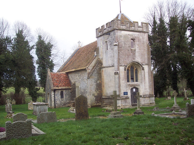
Why visit Shrewton
Townapedia lists 7 museums and landmarks, 2 places to eat and 2 places to stay in and around town.
Highlights include Cursus Barrows and Heelstone Ditch.
Weather in Shrewton
Forecast from MET Norway (CC BY 4.0). Full forecast
About Shrewton
Shrewton is a village and civil parish on Salisbury Plain in Wiltshire, England, around 6 miles (9.7 km) west of Amesbury and 14 miles (23 km) north of Salisbury. It lies on the A360 road between Stonehenge and Tilshead. It is close to the source of the River Till, which flows south to Stapleford.
From the Wikipedia article Shrewton (this version), under CC BY-SA 4.0.
Museums and landmarks7

Cursus Barrows
Monument and historic site · 2.9 mi
Barrow cemetery in England

Heelstone Ditch
Monument and historic site · 3.1 mi
Circular feature surrounding the Heel Stone at Stonehenge

Station Stones
Monument and historic site · 3.4 mi
Elements of prehistoric monument of Stonehenge in Wiltshire,England

Stonehenge Cursus
Monument and historic site · 3.3 mi
Neolithic cursus monument

Robin Hood's Ball
Monument and historic site · 2.5 mi
Archaeological site in Shrewton, Wiltshire, England, UK
Yarnbury Castle
Monument and historic site · 2.9 mi
Site of a multiphase, multivallate iron age hillfort in Wiltshire, England, UK
Restaurants and cafes2
Where to stay2

Churches and places of worship6

St Andrew's Church, Rollestone
Church · 0.4 mi
Church in Shrewton, Wiltshire, England, UK

St George's Church, Orcheston
Church · 1.0 mi
Church in Orcheston, UK
St Mary's Church, Maddington
Church · 0.4 mi
Church in Shrewton, Wiltshire, England, UK

History
The Domesday Book of 1086 recorded three estates held by Edward of Salisbury at Wintreburne, in all with 43 households. The name Shrewton came into use from 1236 and is derived from the Old English scīr-rēfa tūn, meaning 'sheriff's farm or settlement'.
Addeston was a village of medieval origin, which now forms an integral part of the modern village of Shrewton. The place name survives in Addestone Farm (grid reference SU 0655 4300) and Addestone Manor (SU 0673 4330).
A village or hamlet called Netton lay in the east of the parish, but dwindled away by the 19th century; the name survives in Nett Road and Net Down.
In 1934 the civil parish of Shrewton was enlarged by the addition of the parishes of Maddington (to the south and west) and Rollestone (south and east).
RAF Shrewton, a Second World War Royal Air Force airfield with grass runways, was to the north of village. It closed in 1946 and its site returned to farmland.
From the History section of Shrewton on Wikipedia, under CC BY-SA 4.0.
Notable people from Shrewton
 Cecil ChubbBritish lawyer, last private owner of StonehengePhoto: Bain News Service (publisher), Public domain
Born in Shrewton, according to Wikidata (CC0). Each name links to its Wikipedia article.
Schools, colleges and libraries2
Map of Shrewton
19 places. The map loads OpenStreetMap tiles when you open it.
Getting there and nearby towns
Upavon Airfield (UPV) is the nearest airport with scheduled flights listed in OpenStreetMap, 9 miles away.
- Amesbury 5 mi east, about 9 min by car
- Salisbury 10 mi southeast, about 16 min by car
- Tidworth 11 mi east, about 17 min by car
- Devizes 12 mi north, about 19 min by car
- Warminster 12 mi west, about 19 min by car
- Westbury 13 mi west, about 21 min by car
- Trowbridge 16 mi northwest, about 26 min by car
- Melksham 16 mi northwest, about 26 min by car
- Andover 18 mi east, about 29 min by car
- Calne 18 mi north, about 28 min by car
Drive times are estimates from straight-line distance, not routes.
Towns near Shrewton


Keep exploring
Local news
Headlines from INDB.
Reviews, tips and questions
Loading what members have shared...
Sources and licences
- GeoNames (CC BY 4.0): population, coordinates, regions and time zone
- Mapillary (see each image): photos
- OpenStreetMap contributors (ODbL 1.0): places, airports, map data
- Wikidata (CC0 1.0): elevation, founding date, time zone, website, landmarks and historic places
- Wikimedia Commons (see each image): photos
- Wikipedia (CC BY-SA 4.0): overview and history text
Photo credits
- Hants & Dorset NBC preserved bus Bristol VR Warminster Bus Rally in Shrewton, Wiltshire 12 October 2008, David Roberts, CC BY-SA 2.0
- Stonehenge tumulus, Velvet, CC BY-SA 3.0
- Heelstone Ditch & Scroll Trench, Lt.-Col. William Hawley, Public domain
- Stonehenge Cursus, Psychostevouk ( talk ), Public domain
- St Andrew, Rollestone, Simon Huguet, CC BY-SA 2.0
- Orcheston St George, Trish Steel, CC BY-SA 2.0
- Stonehenge DSC 6768, Dietrich Krieger, CC BY-SA 3.0
- Street-level photo, southglos, CC BY-SA 4.0
- Street-level photo, iced, CC BY-SA 4.0
- Street-level photo, RyanBush, CC BY-SA 4.0
Page built November 10, 2026. Spotted a mistake? Tell us or suggest a place.