




Melksham, United Kingdom
Melksham is a town of 19,357 people in England, United Kingdom.
Why visit Melksham
Townapedia lists 5 museums and landmarks, 7 parks and trails, 31 places to eat and 4 places to stay in and around town.
Highlights include Great Chalfield Manor, Lacock Abbey and Whitley Golf Club.
Weather in Melksham
Forecast from MET Norway (CC BY 4.0). Full forecast
About Melksham
Melksham () is a town and civil parish on the River Avon in Wiltshire, England, about 4.5 miles (7 km) northeast of Trowbridge and 6 miles (10 km) south of Chippenham. The parish population was 18,113 at the 2021 census.
From the Wikipedia article Melksham (this version), under CC BY-SA 4.0.
Travel tips from other travellers: Melksham on Wikivoyage (CC BY-SA 4.0).
Museums and landmarks5

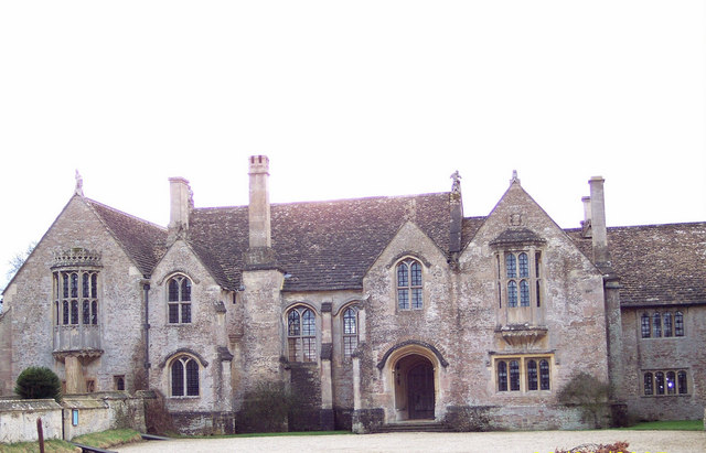
Great Chalfield Manor
Museum · 2.7 mi
Grade I listed English country house in Atworth, Wiltshire, England, UK


Parks, trails and playgrounds7




Restaurants and cafes31
Refa Tandoori
Restaurant · Indian
1-5 Market Place
Open in Google Maps · +44 1225 705680; +44 1225 358428; +44 7853 263565
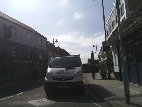
Costa
Cafe · Coffee Shop
47-49 High Street
Mo-Fr 07:00-18:00; Sa 07:30-18:00; Su 08:30-17:00


Lowbourne Cricket Club
Cafe · 0.4 mi
Lowbourne, Melksham
Mo-Th 09:00-17:30; Fr 10:00-17:30; Sa 09:00-17:30; Su 09:00-17:00
19 more on the map.
Where to stay4

History
Excavations in 2021 in the grounds of Melksham House found fragments of locally made pottery from the early Iron Age (7th to 4th centuries BC). There is evidence of settlement continuing into the later Iron Age and Roman periods, including Roman clay roof tiles.
Melksham developed at a ford across the River Avon. The name is presumed to derive from "meolc", the Old English for milk, and "ham", a village. On John Speed's map of Wiltshire (1611), the name is spelt both Melkesam (for the hundred) and Milsham (for the town itself).
Melksham is also the name of the Royal forest that occupied the surrounding of the area in the Middle Ages.
In 1268, Henry III of England gave the manor of Melksham to Amesbury Abbey for the souls of his late cousins Eleanor, Fair Maid of Brittany and Arthur I, Duke of Brittany.
In 1539 the prioress and nuns of Amesbury surrendered to the king their Melksham estates, which they had held for some 250 years. This property, which consisted of the lordship of the manor and hundred, was in 1541 granted to Sir Thomas Seymour. He then sold it to Henry Brouncker, who also had lands nearby at Erlestoke. At some uncertain date, perhaps about 1550, Brouncker built a residence for himself near Melksham church on the site of an earlier mansion. This was known as Place House.
Read more of the history
Three generations of the family lived here: Henry Brouncker the founder, (d.1569), his son, Sir William, and his grandson Henry. On the death of this last Henry, about 1600, it became manifest that the Brouncker estate was heavily encumbered, and in the course of the next twenty or thirty years, all the property was alienated with the exception of Erlestoke, where William Brouncker, the heir, retired with his wife Anne, daughter of Sir John Dauntesey. Meanwhile, Place House was occupied for ten or eleven years by Henry Brouncker's widow and her second husband, Ambrose Dauntesey. After their death, in 1612, the house apparently was occupied by the steward, and afterwards it was conveyed to Sir John Danvers, who married into the family, in 1634. Danvers died in 1655 and the lordship of Melksham passed to his son, who then conveyed the estate to Walter Long the Younger, of Whaddon. The lordship remained in the Long family, who were descended from the first Henry Brouncker, until the early part of the 20th century, having passed to the 1st Viscount Long of Wraxall.
An announcement was made in the Bath Chronicle in June 1792 of the establishment of the Melksham Bank by the firm of Awdry, Long & Bruges. In November 1813 the misquoting of part of an advertisement in two London newspapers caused panic amongst the bank customers, many of whom quickly withdrew their money, reportedly causing "some bustle" among the partners of the bank. There was further trouble in 1812, when the bank was listed on a Parliamentary Paper of the House of Commons under the title "Country Banks Becoming Bankrupt".
Moule's bank became the North Wilts Banking Company in 1835, which merged in 1877 to form Capital and Counties Bank. The latter developed a nationwide branch network and was taken over by Lloyds Bank in 1918.
The Chaloner Lodge of Freemasons (no.2644) was named after its first Worshipful Master Richard Godolphin Walmesley Chaloner, 1st Baron Gisborough, who, when not in London, resided at Melksham House. He was the brother of the 1st Viscount Long. The lodge was consecrated on 27 February 1897, with the first meeting scheduled for 4 pm 19 March, held at the town hall. Writing from London while attending his Parliamentary duties as MP for Westbury, he complained that this date was inconvenient due to his having to be at Melton Mowbray to ride in the House of Commons point to point steeplechase the next day. Despite this, the meeting went ahead and Chaloner initiated 13 of the candidates, returning to London overnight by train, getting virtually no sleep before his ride in the steeplechase early the next morning, resulting in him twice falling heavily from his horse. Later while deciding what extra furniture the lodge required, he asked that he have a special footstool, as his chair was high and his feet "dangled unpleasantly".
In 1815 the Melksham Spa Company was formed by a group of 'respectable gentlemen', with names such as Methuen, Long and others, all of whom had done very well from the now declining textile industry. Their aim was to promote a spa, after abortive attempts to find coal had uncovered two springs. As a consequence they built six large three-storeyed, semi-detached lodging houses forming a crescent, a pump room and hot and cold private baths. This suburban area at the southern end of the town is now known as The Spa, belonging to the civil parish of Melksham Without. A plan for a similar crescent on the north side never materialised. Simultaneously an Act was obtained to 'improve the pleasing town of Melksham' by paving and improving its footways and cleansing, lighting and watching the streets. The spa was not as successful as had been hoped, due in part to the popularity of the waters at nearby Bath.
From the History section of Melksham on Wikipedia, under CC BY-SA 4.0.
More about Melksham
Geography
The civil parish of Melksham includes Melksham Forest, formerly a separate settlement 0.8 miles (1.3 km) to the northeast and now a suburb of the town. It has an Anglican church (St Andrew's, 1876) and had a Methodist chapel (1905 to before 2010).
The parish of Melksham Without includes several villages and suburbs of Melksham:
Bowerhill, a large residential community generally considered as separate from Melksham, with a large industrial area
Berryfield, a village south of and adjacent to Melksham, often considered part of the town
Beanacre, a village to the north, again often considered as a northern suburb of the town.
Economy
The Shell Guide to Wiltshire, published in 1968, characterised the town as "with the exception of Swindon the most industrialized in the county". Today, Melksham has varied industries including Avon Rubber, which previously owned the Avon Tyre plant on a riverside site in the town centre. The plant became the home of Cooper Tire & Rubber (a subsidiary of the American Goodyear company) and was a major employer in the town, producing Cooper Avon and Avon Tyres brands until the site closed at the end of 2023. In 2000, Avon Rubber moved to a large purpose-built facility 3 km (1.9 mi) to the south of the town near Semington, employing over 300 on products such as gasmasks.
Also to the south of the town, an area of light industry at Bowerhill is partly on the site of the former RAF Melksham training schools. Modern buildings here include regional headquarters designed by Sir Nicholas Grimshaw for the American office furniture maker Herman Miller, and the UK headquarters of Knorr-Bremse, designer and manufacturer of railway braking systems.
Melksham has a number of pharmacies, high street clothes shops, charity shops and privately run individual stores. It has five supermarkets: Asda, Sainsbury's, Waitrose, Lidl and Aldi.
Arts and culture
Melksham has an Assembly Hall and the Rachel Fowler Centre, while many of the surrounding villages have community halls which offer a wide variety of activities. Melksham Oak Community School offers a variety of sporting and cultural facilities to the community of Melksham.
The town has an annual 'Party in the Park' which usually takes place in July. It includes a fair with rides and amusements, a fireworks display, a stage hosting musical and dance acts and a carnival parade through the town with floats promoting local businesses and clubs and raising money for charity.
Education
The Manor C of E VC Primary School (formerly Lowbourne Junior, St Michaels School)
River Mead School (formerly King's Park Primary School, Lowbourne Infants School)
There is one secondary school in the Melksham catchment area: Melksham Oak Community School opened in 2010 at Bowerhill, replacing The George Ward Technology College which served the community for over 50 years.
Stonar School, an all-ages independent day and boarding school, is nearby at Atworth.
From the Wikipedia article Melksham, under CC BY-SA 4.0.
Notable people from Melksham
 Sidney Leslie GoodwinBritish victim of the RMS Titanic sinking (1910–1912)Photo: Unknown author Unknown author, Public domain
 Henry MouleEnglish inventor (1801-1880)Photo: Musphot, CC BY-SA 3.0
- John Fowleragricultural engineer (born 1826)
- Matthew BoundEnglish footballer (born 1972)
- John RuttyIrish Quaker physician and naturalist
- Christopher Evans-IronsideSongwriter, composer and music producer
- Adrian RoomBritish toponymist (1933-2010)
- William Raymond FellNew Zealand policeman
- Ken GillBritish trade union leader (1927-2009)
Born in Melksham, according to Wikidata (CC0). Each name links to its Wikipedia article.
Churches and places of worship13
Shopping8
Gas and EV charging9
Schools, colleges and libraries7
Forest and Sandridge Church of England Primary School
School · Anglican · 1.0 mi
Cranesbill Road, Melksham
St Mary's Broughton Gifford Voluntary Controlled Church of England Primary School
School · Anglican, Methodist · 1.5 mi
The Street, Melksham
Healthcare3
Map of Melksham
87 places. The map loads OpenStreetMap tiles when you open it.
Getting there and nearby towns
Upavon Airfield (UPV) is the nearest airport with scheduled flights listed in OpenStreetMap, 17 miles away.
- Westbury 8 mi south, about 13 min by car
- Bath 10 mi west, about 15 min by car
- Warminster 12 mi south, about 19 min by car
- Royal Wootton Bassett 15 mi northeast, about 25 min by car
- Midsomer Norton 16 mi west, about 26 min by car
- Yate 17 mi northwest, about 27 min by car
- Bristol 20 mi west, about 33 min by car
- Swindon 20 mi northeast, about 32 min by car
- Stoke Gifford 20 mi northwest, about 32 min by car
- Shepton Mallet 22 mi southwest, about 35 min by car
Drive times are estimates from straight-line distance, not routes.
Towns near Melksham


Keep exploring
Local news
Headlines from INDB.
Reviews, tips and questions
Loading what members have shared...
Sources and licences
- GeoNames (CC BY 4.0): population, coordinates, regions and time zone
- Mapillary (see each image): photos
- OpenStreetMap contributors (ODbL 1.0): places, airports, map data
- Wikidata (CC0 1.0): elevation, founding date, time zone, website, landmarks and historic places
- Wikimedia Commons (see each image): photos
- Wikipedia (CC BY-SA 4.0): overview and history text
Photo credits
- Melksham Market Place, en:User:My another account, CC BY-SA 3.0
- The Roundhouse, Melksham, and yew tree, Moonraker, CC BY-SA 4.0
- The Roundhouse, Melksham, Moonraker, CC BY-SA 4.0
- Great Chalfield Manor 12, Trish Steel, CC BY-SA 2.0
- Lacock Abbey view from south, Jürgen Matern, CC BY-SA 2.5
- St. Michael & All Angels (13544583034), Hugh Llewelyn from Keynsham, UK, CC BY-SA 2.0
- Shaw church, My another account at en.wikipedia, Public domain
- Beanacre, My another account at English Wikipedia, Public domain
- Oakfield Stadium, Jack Slade The Englishman, CC BY-SA 4.0
- Street-level photo, RyanBush, CC BY-SA 4.0
- Street-level photo, jarosor0, CC BY-SA 4.0
- Street-level photo, chris_debian, CC BY-SA 4.0
- Street-level photo, noid, CC BY-SA 4.0
- Street-level photo, chris_debian, CC BY-SA 4.0
- Street-level photo, southglos, CC BY-SA 4.0
- Street-level photo, southglos, CC BY-SA 4.0
- Street-level photo, chris_debian, CC BY-SA 4.0
- Street-level photo, jarosor0, CC BY-SA 4.0
- Street-level photo, chris_debian, CC BY-SA 4.0
- Street-level photo, chris_debian, CC BY-SA 4.0
- Street-level photo, jarosor0, CC BY-SA 4.0
- Street-level photo, jarosor0, CC BY-SA 4.0
- Street-level photo, chris_debian, CC BY-SA 4.0
- Street-level photo, jarosor0, CC BY-SA 4.0
- Street-level photo, noid, CC BY-SA 4.0
- Street-level photo, chris_debian, CC BY-SA 4.0
- Street-level photo, chris_debian, CC BY-SA 4.0
- Street-level photo, southglos, CC BY-SA 4.0
- Street-level photo, jarosor0, CC BY-SA 4.0
- Street-level photo, chris_debian, CC BY-SA 4.0


Page built November 10, 2026. Spotted a mistake? Tell us or suggest a place.