


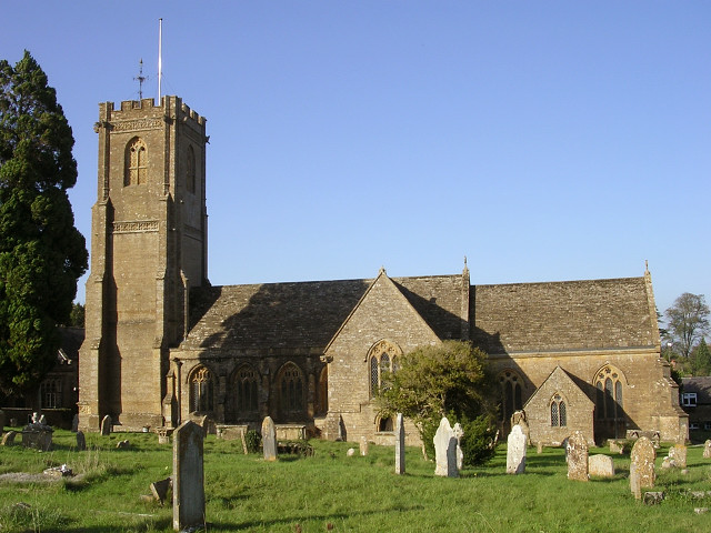


West Coker, United Kingdom
West Coker is a town of 1,161 people in England, United Kingdom.
Why visit West Coker
Townapedia lists 6 museums and landmarks, 4 parks and trails, 5 places to eat, 1 place to stay and 2 attractions in and around town.
Highlights include Ham Hill, Montacute House, Ninesprings and Hardington Moor National Nature Reserve.
Weather in West Coker
Forecast from MET Norway (CC BY 4.0). Full forecast
About West Coker
West Coker is a large village and civil parish in Somerset, England, situated 3 miles (4.8 km) south west of Yeovil.
From the Wikipedia article West Coker (this version), under CC BY-SA 4.0.
Things to do2

Museums and landmarks6

Ham Hill
Monument and historic site · 2.9 mi
Hillfort in Somerset, England, UK

Montacute House
Museum · 2.5 mi
Late Elizabethan mansion with garden in Montacute, South Somerset, England, UK

Montacute Priory
Monument and historic site · 2.4 mi
Priory in Somerset, England, UK



Parks, trails and playgrounds4

Ninesprings
Park · 2.6 mi
Country park near Yeovil, Somerset, England



Restaurants and cafes5

Wooden Top Inn
Bar and pub · Regional · 1.4 mi
Formerly known as Portman Arms
High Street, East Chinnock

History
The name Coker comes from Coker Water ("crooked stream" from the Celtic Kukro).
Artifacts from early settlement in the parish include a polished stone axe and boat shaped-bronze brooch. A Roman villa has been excavated and a bronze plate inscribed to the god Mars discovered. From this Mars was given the title Mars Rigisamus (which means "greatest king" or "king of kings") as it depicts a standing naked male figure with a close-fitting helmet; his right hand may have once held a weapon, and he probably originally also had a shield (both are now lost). The same epithet for a god is recorded from Bourges in Gaul. The use of this epithet implies that Mars had an extremely high status, over and above his warrior function.
The manor descended with its neighbour East Coker until the 14th century when it passed to a junior branch of the Courtenay family. It was later held by the Dukes of Somerset and Northumberland protectors of Edward VI and later still by the Portmans of Orchard Portman.
The original manor house burned down during an attack in the Wars of the Roses, although the current hamstone manor house has medieval origins, the earliest surviving portions probably being of around 1500. It is a grade I listed building.
Read more of the history
The village had a long history of growing hemp and flax for sailcloth manufacture, which made "Coker Canvas" highly prized by naval captains during the Napoleonic Wars. Dawe's Twineworks, a late 19th-century historic building in the village used for the manufacture of rope and twine, was a featured candidate on the BBC Restoration TV series in 2006. The ropewalk was on the Heritage at Risk Register until local volunteers formed the Coker Rope & Sail Trust and raised substantial funding, including from the National Lottery Heritage Fund. Dawe's Twineworks is now Britain’s only surviving Victorian twineworks with its original working machinery, and is open to visitors on the fourth Saturday of every month.
From the History section of West Coker on Wikipedia, under CC BY-SA 4.0.
More about West Coker
Geography
Nearby is the Hardington Moor Site of Special Scientific Interest and national nature reserve where meadows are examples of species-rich unimproved neutral grassland, which is now nationally rare. The rare French oat-grass is very abundant on the site and the fields are home to a wide variety of plant species, most notably adder's tongue, corky-fruited water-dropwort and large numbers of green-winged orchid. Invertebrates found at the site include butterflies such as gatekeeper, small tortoiseshell and common blue. Less commonly seen are large skipper, green-veined white and green hairstreak.
From the Wikipedia article West Coker, under CC BY-SA 4.0.
Where to stay1
Churches and places of worship24
Shopping1
Gas and EV charging1
Schools, colleges and libraries2
Map of West Coker
46 places. The map loads OpenStreetMap tiles when you open it.
Getting there and nearby towns
Royal Naval Air Station Yeovilton (YEO) is the nearest airport with scheduled flights listed in OpenStreetMap, 6 miles away.
- Yeovil 3 mi northeast, about 5 min by car
- Yetminster 5 mi east, about 8 min by car
- Chard 13 mi west, about 20 min by car
- Bridport 13 mi south, about 21 min by car
- Street 14 mi north, about 23 min by car
- Westonzoyland 17 mi northwest, about 27 min by car
- Dorchester 18 mi southeast, about 29 min by car
- Taunton 19 mi west, about 31 min by car
- Bridgwater 20 mi northwest, about 32 min by car
- Shepton Mallet 20 mi north, about 32 min by car
Drive times are estimates from straight-line distance, not routes.
Towns near West Coker


Keep exploring
Local news
Headlines from INDB.
Reviews, tips and questions
Loading what members have shared...
Sources and licences
- GeoNames (CC BY 4.0): population, coordinates, regions and time zone
- Mapillary (see each image): photos
- OpenStreetMap contributors (ODbL 1.0): places, airports, map data
- Wikidata (CC0 1.0): elevation, founding date, time zone, website, landmarks and historic places
- Wikimedia Commons (see each image): photos
- Wikipedia (CC BY-SA 4.0): overview and history text
Photo credits
- West Coker, John Barnes, CC BY-SA 2.0
- Somerset Panorama 6, Ham Hill (338485474), bixentro, CC BY 2.0
- 1252021 I Montacute House, seen from E Montacute 20250830 0006, Tilman2007, CC BY-SA 4.0
- St Catherines church Montacute, Jim Champion, CC BY-SA 2.0
- Yeovilstjohns, Chris McMillan, CC BY-SA 2.0
- Hardingtonmoor, Rupert Fleetingly, CC BY-SA 2.0
- Brympton dEvercy 03, Ronald Searle, CC BY-SA 2.0
- Manor House, West Coker, c.1894, Unknown author Unknown author, CC BY-SA 4.0
- Montacute Priory Gatehouse, Stevekeiretsu, CC BY-SA 4.0
- Lake at Ninesprings Country Park, Marley Sexton, CC0
- Street-level photo, southglos, CC BY-SA 4.0
- Street-level photo, richardc, CC BY-SA 4.0
- Street-level photo, southglos, CC BY-SA 4.0
Page built November 10, 2026. Spotted a mistake? Tell us or suggest a place.