
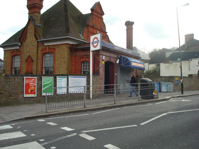


Wimbledon Park, United Kingdom
Wimbledon Park is a town of 11,197 people in England, United Kingdom.
Why visit Wimbledon Park
Townapedia lists 40 museums and landmarks, 81 parks and trails, 243 places to eat, 10 places to stay and 20 attractions in and around town.
Highlights include Polka Theatre, New Wimbledon Theatre, Museum of Wimbledon and Wimbledon Lawn Tennis Museum.
Weather in Wimbledon Park
Forecast from MET Norway (CC BY 4.0). Full forecast
About Wimbledon Park
Wimbledon Park is the name of an urban park in Wimbledon and also of the suburb south and east of the park and the Wimbledon Park tube station. The park itself is 27 hectares (67 acres) in area. The All England Lawn Tennis and Croquet Club is immediately to the west of the park. Wimbledon Park is not part of Wimbledon Common, which is situated further to the west up the hill.
From the Wikipedia article Wimbledon Park (this version), under CC BY-SA 4.0.
Photos of Wimbledon Park

Things to do20

Polka Theatre
Cinema and theater · 1.1 mi
Children's theater in Wimbledon, London Borough of Merton, England
238-244 The Broadway, London
We-Fr 09:30-16:30; Sa-Su 10:00-16:30

New Wimbledon Theatre
Cinema and theater · 1.1 mi
Theatre in Wimbledon, Merton, London, England, UK
93 The Broadway, London

Battersea Arts Centre
Cinema and theater · 2.6 mi
Performance space in the London Borough of Wandsworth, England, the former Battersea Town Hall

Battersea Railway Bridge
Bridge · 2.8 mi
Bridge across the River Thames in London

Chelsea Theatre
Cinema and theater · 3.3 mi
Studio theatre in Chelsea, London, England

Fulham Railway Bridge
Bridge · 2.2 mi
Truss bridge that crosses the River Thames in London, which carries both trains and pedestrians

Granada, Tooting
Cinema and theater · 1.5 mi
Former theatre and cinema, now bingo hall, in Tooting, Wandsworth, London, England, UK

Putney Bridge
Bridge · 2.3 mi
Grade II listed road bridge in London Boroughs of Wandsworth and Hammersmith and Fulham



8 more on the map.
Museums and landmarks40


Wimbledon Lawn Tennis Museum
Museum · 0.6 mi
Museum in England
Apr-Sep 10:00-17:30; Oct-Mar 10:00-17:00


Bolan's Rock Shrine
Monument and historic site · 2.7 mi
Memorial in Barnes, London

Fulham Palace
Museum · 2.6 mi
Grade I listed historic house museum in London Borough of Hammersmith and Fulham, United Kingdom

New Malden War Memorial
Monument and historic site · 3.3 mi
War memorial in New Malden, Royal Borough of Kingston upon Thames, London, England, UK

Putney Sculpture Trail
Museum · 2.6 mi
Sculpture trail in south-west London


chairman Gallery
Museum · 1.7 mi
Contemporary art gallery in Wimbledon, London
Mausoleum Of Sir Joseph William Bazalgette 20 Yards To North East Of Chancel Of St Marys Church
Monument and historic site · 0.7 mi
Mausoleum in Merton, London, England, UK
Southside House
Museum · 2.0 mi
Historic house museum in the London Borough of Merton, UK
28 more on the map.
Parks, trails and playgrounds81


Cannizaro Park
Park · 1.6 mi
Park in the London Borough of Merton, England,UK


Coombe Hill Wood
Park · 2.5 mi
Nature reserve in Coombe, Kingston upon Thames, Greater London, England, UK

Barn Elms
Park · 3.0 mi
Open space in Barnes in the London Borough of Richmond upon Thames
Beverley Park
Park · 2.9 mi
Park in Kingston upon Thames, London, England, UK
69 more on the map.
Restaurants and cafes243

Spread Eagle
Bar and pub · 1.5 mi
69-71 Wandsworth High Street, London
Mo-Th 07:00-23:00, Fr 07:00-00:00, Sa 08:00-00:00, Su 08:00-22:30

The Nelson Arms
Bar and pub · 1.4 mi
15 Merton High Street, London
Mo-Th 16:00-23:00; Fr 16:00-00:00; Sa 12:00-00:00; Su 12:00-22:30

The Ram Inn
Bar and pub · 1.5 mi
68 Wandsworth High Street, London
Mo 09:00-23:00; Tu-Sa 12:00-23:00; Su 12:00-22:30

The Holden
Bar and pub · 1.5 mi
198 High Street Colliers Wood, London
Su-Th 12:00-23:00, Fr,Sa 12:00-24:00

The Wibbas Down Inn
Bar and pub · 1.1 mi
6-12 Gladstone Road, London
Su-Th 08:00-00:00; Fr-Sa 08:00-01:00

NYEAT
Restaurant · American, Steak House, Lobster, Seafood, Barbecue · 0.5 mi
NYEAT offers an urban chic experience with contemporary American cuisine, amazing cocktails, upbeat music, and chic decor that has...
14 Leopold Road, London
Tu-Fr 18:00-23:00; Sa 13:00-23:00; Su 13:00-22:30
Bobochacha
Restaurant · Asian · 1.1 mi
77 The Broadway, London
Mo-Th 12:00-15:00, 17:00-22:00; Fr 12:00-15:00, 17:00-22:30; Sa...
Bombay Delight
Restaurant · Indian · 1.1 mi
271-273 The Broadway, London
Mo-Fr 11:30-15:00, 17:30-22:30; Sa 11:00-22:30; Su 11:00-22:00

Caffè Nero
Cafe · Coffee Shop · 1.0 mi
6 The Broadway, London
Mo-Fr 06:30-19:30; Sa 07:30-19:30; Su,PH 07:30-19:00
Caffè Nero
Cafe · Coffee Shop · 1.4 mi
60A Garratt Lane, London
Mo-Fr 07:00-19:00; Sa 07:30-19:30; Su 08:00-18:30
Côte Brasserie
Restaurant · French · 1.0 mi
8 High Street, London
Mo-Fr 08:00-23:00; Sa 09:00-23:00; Su 09:00-22:30
231 more on the map.
Notable people from Wimbledon Park
- Alvar LidellRadio news presenter
- John Peppercricketer (born 1922)
Born in Wimbledon Park, according to Wikidata (CC0). Each name links to its Wikipedia article.
Where to stay10
Holiday Inn Express
Motel and hotel · 1.5 mi
200 High Street Colliers Wood, London
Churches and places of worship81
Shopping72
Gas and EV charging12
Schools, colleges and libraries62
Healthcare36
Map of Wimbledon Park
250 places. The map loads OpenStreetMap tiles when you open it.
Getting there and nearby towns
Heathrow Airport (LHR) is the nearest airport with scheduled flights listed in OpenStreetMap, 11 miles away.
- Balham 2 mi northeast, about 4 min by car
- Barnes 3 mi northwest, about 5 min by car
- Worcester Park 4 mi southwest, about 7 min by car
- City of Westminster 5 mi northeast, about 8 min by car
- Kingston upon Thames 5 mi west, about 7 min by car
- Richmond 5 mi west, about 8 min by car
- Thornton Heath 5 mi southeast, about 8 min by car
- Kew 5 mi northwest, about 8 min by car
- London 6 mi northeast, about 10 min by car
- Croydon 6 mi southeast, about 9 min by car
Drive times are estimates from straight-line distance, not routes.
Towns near Wimbledon Park


Keep exploring
Local news
Headlines from INDB.
Reviews, tips and questions
Loading what members have shared...
Sources and licences
- GeoNames (CC BY 4.0): population, coordinates, regions and time zone
- Mapillary (see each image): photos
- OpenStreetMap contributors (ODbL 1.0): places, airports, map data
- Wikidata (CC0 1.0): elevation, founding date, time zone, website, landmarks and historic places
- Wikimedia Commons (see each image): photos
- Wikipedia (CC BY-SA 4.0): overview and history text
Photo credits
- Wimbledon Park Underground Station, Stacey Harris, CC BY-SA 2.0
- Wimbledonpark, Bumper12 at English Wikipedia / Stu Clayton, Public domain
- Polka Theatre, PolkaDawn, Public domain
- New Wimbledon Theatre (6856272185), Images George Rex from London, England, CC BY-SA 2.0
- Battersea Arts Centre, Lavender Hill, SW11 (3324322940), Ewan Munro from London, UK, CC BY-SA 2.0
- Battersea Railway Bridge, London 04, Edwardx, CC BY-SA 3.0
- Chelsea Theatre London, tomislav medak, CC BY 2.0
- FulhamRailwayBridge, Graeme Kerr, CC BY 2.5
- Gala Bingo, Tooting, SW17, Ewan Munro, CC BY-SA 2.0
- Putney Bridge, No machine-readable author provided. Nichtbesserwisser assumed (based on copyright claims)., Public domain
- Theatre 503, Mx. Granger, CC0
- Wimbledon Lawn Tennis Museum (485259229), ozziebackpacker, CC BY 2.0
- Marc Bolan's Rock Shrine - 1 - 2023-01-21, The wub, CC BY-SA 4.0
- Fulham Palace, Michael Coppins, CC BY-SA 4.0
- New Malden War Memorial, outside the old Town Hall, AndyScott, CC BY-SA 4.0
- King George's Park Pond - panoramio, pudina, CC BY 3.0
- Bishops-park, Peter Damian, CC BY-SA 3.0
- Cherry Wood 3, Dudley Miles, CC BY-SA 3.0
- Clapham Common 360 Panorama - July 2007, Diliff, CC BY 3.0
- Coombe Hill Wood 5, Dudley Miles, CC BY-SA 3.0
- Fazl Moschee, Ceddyfresse, Public domain
- The quad, William.brierly, CC BY-SA 4.0
- Royal Hospital for Neuro-disability, Stevekeiretsu, CC BY-SA 3.0
- Sacred Heart RC Church, Wimbledon, London, UK - Diliff, Diliff, CC BY-SA 3.0
- Stmaryswimbledonsw19, Bycostello, CC BY-SA 3.0
- Wimbledon Windmill, Adrian Robson at English Wikipedia, Public domain
- St C-5736, Gordon Render, CC BY-SA 4.0
- St Anne's Church, Wandsworth, Stevekeiretsu, CC BY-SA 3.0
- Museum of Wimbledon, No Swan So Fine, CC BY-SA 4.0
- St Luke's church, Wimbledon Park, Stevekeiretsu, CC BY-SA 4.0
- Brewery Tap, Wandsworth, SW18 (2384001310), Ewan Munro from London, UK, CC BY-SA 2.0
- Colliers Wood library (39532453795), JuliaC2006 from Rochester, UK, CC BY 2.0
- Tooting library (28300554854), Libraries Taskforce, CC BY 2.0
- Wibbas Down Inn, Wimbledon, SW19 (3958013789), Ewan Munro from London, UK, CC BY-SA 2.0
- The Nelson Arms, Merton High Street, Simon from London, United Kingdom, CC BY 2.0
- The Charles Holden, TheFrog001, CC0
- St Andrew's Church, Wimbledon, www.achurchnearyou.com, CC BY-SA 4.0
- ISH CannonHillCommon1, Ian Howard www.ianhoward.smugmug.com aka Drianhoward at en.wikipedia, CC BY 2.5
- Fazl-Moschee 2010, Ceddyfresse, Public domain
- Exodus, Alan Thornhill 20201001 121844 (50403513713), Irid Escent, CC BY-SA 2.0
- Wandle Meadow Nature Park 3, Dudley Miles, CC BY-SA 3.0
- Bennett's Hole and River Wandle 4, Dudley Miles, CC BY-SA 3.0
- Fountain in Cannizaro Park, Laura Nolte, CC BY 2.0
- Spread Eagle Wandsworth, Jwslubbock, CC BY-SA 4.0
- Street-level photo, livingwithdragons, CC BY-SA 4.0
- Street-level photo, cyclestreets, CC BY-SA 4.0
- Street-level photo, IpswichEdits, CC BY-SA 4.0
- Street-level photo, julianlb, CC BY-SA 4.0
- Street-level photo, IpswichEdits, CC BY-SA 4.0


Page built November 10, 2026. Spotted a mistake? Tell us or suggest a place.