


Why visit Aberporth
Townapedia lists 8 museums and landmarks, 12 parks and trails, 11 places to eat, 8 places to stay and 1 attraction in and around town.
Highlights include Internal Fire - Museum of Power, Dyffryn-Bern Stone, Tresaith and Penbryn Beach.
Weather in Aberporth
Forecast from MET Norway (CC BY 4.0). Full forecast
About Aberporth
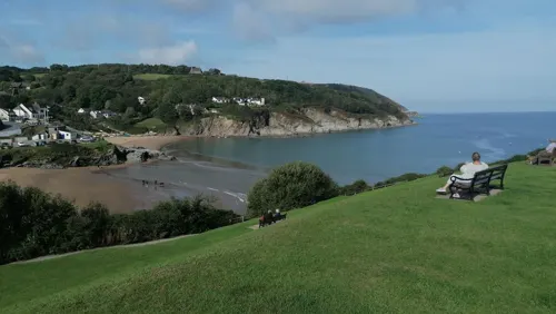
Aberporth is a seaside village, community and electoral ward in Ceredigion, Wales. The population at the 2001 Census, was 2,485, of whom 49 per cent could speak the Welsh language. At the 2011 Census, the population of the community was 2,374 and of the village 1241. Aberporth's beaches have earned Blue Flag status.
From the Wikipedia article Aberporth (this version), under CC BY-SA 4.0.
Travel tips from other travellers: Aberporth on Wikivoyage (CC BY-SA 4.0).
Photos of Aberporth


Things to do1

Museums and landmarks8

Internal Fire - Museum of Power
Museum · 2.3 mi
Technology museum in Ceredigion, Wales, United Kingdom

Dyffryn-Bern Stone
Monument and historic site · 1.7 mi
Inscribed stone approx 0.6 by 0.75m in section and 1.45m high. Inscription translates as [The stone of] Corbalengus. [Here] he lies,...
Blaenannerch Round Barrow
Monument and historic site · 1.6 mi
Originally circular, ploughing has resulted in it becoming oval. Approx 48m N-S, 38m E-W, 1.7m high. Electricity pole has been erected...
Caer Pwntan
Monument and historic site · 2.2 mi
Oval, bivallate enclosure extensively mutilated by quarrying and agriculture.
Jenkins Monument
Monument and historic site · 0.4 mi
Mid 19th-century monument to Capt. T. Jenkins of the East India Company. Table tomb in large square railed enclosure.
Parks, trails and playgrounds12




Restaurants and cafes11

Tracy's Refreshments
Fast food · Regional · 2.4 mi
Mo-Fr 08:00-15:00; Sa 09:00-14:30



History
In the 16th century, boats, nets and salt for preserving were brought in from Ireland. Aberporth became a subsidiary port of Cardigan. The landing point developed rapidly in the late 17th and early 18th centuries as local people began to take part in the maritime trade. It became a very active port; the northern of the two beaches extended into the river valley and provided a safe anchorage. Lime kilns, coal yards and warehouses were built on its south shore.
Aberporth developed into a centre of the herring fishing industry in Wales. Drifting and netting were both employed, and at one time at least 20 full-time herring smacks, a type of traditional fishing boat, went to sea regularly. The industry continued until the beginning of the First World War, when fish stocks declined.
From the History section of Aberporth on Wikipedia, under CC BY-SA 4.0.
More about Aberporth
Education
Aberporth School, established in 1834, had 31 pupils in 1836. In 1854, a building for 110 pupils was built; average attendance in 1904 was 68. It was a national school providing elementary education, in accordance with the teaching of the Church of England, to the children of the poor. In 1926, it became a Church of England school.
Ysgol Gymunedol Aberporth is the present-day primary school in Aberporth. There were 122 pupils on the roll in 2013. Only 12 per cent came from homes where Welsh was the main language (down from 16 per cent in 2007). It was in the A/B category according to the Local Education Authority's language policy in 2001, but by 2007, it had changed into a category A school, meaning that Welsh is now the main language of teaching there.
From the Wikipedia article Aberporth, under CC BY-SA 4.0.
Notable people from Aberporth
- Ricky EvansWelsh rugby union player
Born in Aberporth, according to Wikidata (CC0). Each name links to its Wikipedia article.
Where to stay8
Churches and places of worship11
Shopping1
Schools, colleges and libraries1
Map of Aberporth
53 places. The map loads OpenStreetMap tiles when you open it.
Getting there and nearby towns
Haverfordwest Airport (HAW) is the nearest airport with scheduled flights listed in OpenStreetMap, 27 miles away.
- Cardigan 6 mi southwest, about 10 min by car
- Newcastle Emlyn 7 mi southeast, about 11 min by car
- Llangeler 10 mi southeast, about 16 min by car
- Llandysul 12 mi southeast, about 19 min by car
- Lampeter 20 mi east, about 32 min by car
- Fishguard 21 mi southwest, about 33 min by car
- Goodwick 21 mi southwest, about 34 min by car
- Carmarthen 22 mi southeast, about 35 min by car
- Saint Clears 22 mi south, about 35 min by car
- Whitland 22 mi south, about 35 min by car
Drive times are estimates from straight-line distance, not routes.
Towns near Aberporth


Keep exploring
Local news
Headlines from INDB.
Reviews, tips and questions
Loading what members have shared...
Sources and licences
- GeoNames (CC BY 4.0): population, coordinates, regions and time zone
- Mapillary (see each image): photos
- OpenStreetMap contributors (ODbL 1.0): places, airports, map data
- Wikidata (CC0 1.0): elevation, founding date, time zone, website, landmarks and historic places
- Wikimedia Commons (see each image): photos
- Wikipedia (CC BY-SA 4.0): overview and history text
Photo credits
- Aberporth 978623, Deborah Tilley, CC BY-SA 2.0
- 2014-03-19 Aberporth 01, Gareth Wyn Jones, CC BY-SA 4.0
- 2014-03-11 Aberporth-Tresaith 05, Gareth Wyn Jones, CC BY-SA 4.0
- 2014-03-11 Aberporth-Tresaith 04, Gareth Wyn Jones, CC BY-SA 4.0
- Aberporth - panoramio (1), Tanya Dedyukhina, CC BY 3.0
- 2014-03-19 Aberporth 02, Gareth Wyn Jones, CC BY-SA 4.0
- 2014-03-19 Aberporth 03, Gareth Wyn Jones, CC BY-SA 4.0
- Allen 3S47, Hall 5, Andy Dingley, CC BY-SA 3.0
- Mwnt, Ceredigion, gydag Eglwys y Grog, y traeth a Foel-y-Mwnt - Mwnt, Ceredigion, Wales 94, Llywelyn2000, CC BY-SA 4.0
- St Michaels Penbryn, Matt Phillips, CC BY-SA 4.0
- Aberporth - panoramio (7), Tanya Dedyukhina, CC BY 3.0
- Tre-saith, Ceredigion - Tresaith in Wales - too much tourism and danger of landslide of rocks 13, Llywelyn2000, CC BY-SA 4.0
- Ship Inn (1), GeraintTudur2, CC BY-SA 3.0
- Ffynnonbedr Welsh Independent Chapel, GeraintTudur2, CC BY-SA 3.0
- St Michael, Penbryn, Ken Greenslade, CC BY-SA 4.0
- Street-level photo, mjc506, CC BY-SA 4.0
- Street-level photo, trigpoint, CC BY-SA 4.0
- Street-level photo, mjc506, CC BY-SA 4.0
- Street-level photo, mjc506, CC BY-SA 4.0
- Street-level photo, pgs32, CC BY-SA 4.0


Page built November 10, 2026. Spotted a mistake? Tell us or suggest a place.