
Why visit Aspatria
Townapedia lists 2 museums and landmarks, 2 parks and trails and 10 places to eat in and around town.
Highlights include Brayton Park Golf Club.
Weather in Aspatria
Forecast from MET Norway (CC BY 4.0). Full forecast
About Aspatria
Aspatria is a town and civil parish in Cumberland, Cumbria, England. The town rests on the north side of the Ellen Valley, overlooking a panoramic view of the countryside, with Skiddaw to the South and the Solway Firth to the North. Its developments are aligned approximately east–west along the A596 Carlisle to Workington road and these extend to approximately 2 miles (3.2 km) in length. It lies about 8 miles (13 km) northeast of Maryport, a similar distance to the Southwest of Wigton, about 9 miles (14 km) north of Cockermouth and 5 miles (8.0 km) from the coast and Allonby.
From the Wikipedia article Aspatria (this version), under CC BY-SA 4.0.
Museums and landmarks2

Parks, trails and playgrounds2


Restaurants and cafes10




Churches and places of worship4


St James' Church, Hayton
Church · 2.3 mi
Church in Hayton, Allerdale, Cumbria, United Kingdom
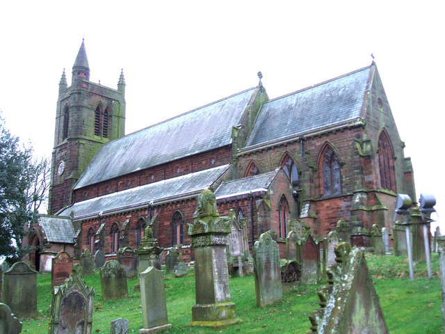
St. Kentigern's Church, Aspatria
Church
Church in Aspatria, Cumberland, Cumbria , England, UK
History
Aspatria is an ancient settlement and seems to have been home to a group of Norsemen who fled to the area from Ireland around 900. In 1789, a surgeon by the name of Rigg employed a group of labourers to level a mound called Beacon Hill, situated close behind his house at Aspatria. After reaching a depth of about one metre they dug into a cavity walled around with large stones and found the skeleton of a Viking chief. At the head of the skeleton lay a sword almost five feet in length, with a remarkably broad blade, ornamented with a gold and silver handle. The scabbard of the sword was made of wood, lined with cloth. The workmen also unearthed several pieces of armour, a dirk with a silver studded handle, a golden buckled belt, and a breast plate. The artefacts remain the property of the British Museum. Further finds were made on the same site in 1997 when a mobile phone mast was being constructed.
Read more of the history
The manor of Aspatria is part of the ancient barony of Allerdale below Derwent. Awarded by Ranulph de Meschines, grantee of the whole of Cumberland from William the Conqueror, to Waltheof, son of Gospatrick, Earl of Dunbar, from whom the obsolete name of Aspatrick, may have been derived. Upon the division of the estates of William Fitz Duncan, and his wife Alice de Romney, among their three daughters, the manor passed to Alice, the youngest. However, Alice died without issue and the estates passed to an elder sister who had married into the Lucy family. The latter family terminated in a female heir Maud de Lucy. She married Henry Percy, the first Earl of Northumberland, who received the whole of her estates. It remained in this family through eleven generations before passing by the marriage of Lady Elizabeth, sole daughter and heiress of Josceline Percy to Charles Seymour, sixth Earl of Somerset. In recent times it again passed by a female heir to the Wyndham family, from whom it has descended to Lord Leconfield and now Lord Egremont.
The village stands at the northern end of the West Cumberland Coalfield and there have been mines in the area since the 16th century. The opening of the Maryport and Carlisle Railway, in 1842, led to a rapid expansion of the industry. The Brayton Domain Collieries sank five different pits around the town at various times and there were also mines near Mealsgate, Baggrow and Fletchertown. In 1902, a new mine was sunk at Oughterside. The last pit in the town, Brayton Domain No.5, closed in 1940.
In 1870, one of England's first farmers' co-operatives, the Aspatria Agricultural Cooperative Society was established here with offices in the market square, facing the Aspatria Agricultural College which flourished from 1874 until 1925.
Sir Wilfrid Lawson MP (1829–1906) lived at Brayton Hall just outside the town. He was a committed nonconformist and a leader of the Temperance Movement. His memorial stands in the market square, topped by a bronze effigy of St George slaying the dragon – said to represent the demon drink. Brayton Hall was destroyed by fire in 1918.
According to one source, the origins of the name of Aspatria lie in Old Scandinavian and Celtic. It translates as "Ash-tree of St Patrick", and is composed of the elements askr (Old Scandinavian for "ash-tree") and the Celtic saint's name. The order of the elements of the name, with the ash-tree coming before the name of the saint, is particular to Celtic place-names. The following forms of the name have been found in various charters:- Estpatrick in 1224, Asepatrick 1230, Aspatric 1233, Askpatrik 1291, Assepatrick 1303, Aspatrick 1357, Aspatre 1491. The first entry in the parish register referring to the town as Aspatria in preference to the name Aspatrick or Aspatricke appears in 1712. It appears in the handwriting of the then vicar David Bell. For the next fifty years the spelling fluctuated until eventually Aspatria became the dominant name. When Charles Dickens and Wilkie Collins passed through the town in 1857 they referred to the name Spatter which is not too dissimilar to 'Speatrie' the name locals prefer. William Brough, a railway porter, discharging third class passengers after their arrival at Aspatria from the Bolton Loop railway connection would cry 'Speatrie Loup Oot'. Second class passengers would detect "Speatrie change ere for Measyat", while first class passengers heard a polite invitation, "Aspatriah, change heah for Mealsgate."
There is a legend that the name comes from the ash tree that grew when St. Patrick's staff, the Bachal Isu, took root in the ground because it took so long for him to manage to convert the people from this area to Christianity.
From the History section of Aspatria on Wikipedia, under CC BY-SA 4.0.
More about Aspatria
Education
There are two primary schools in the town: Oughterside Primary School and Richmond Hill School.
Beacon Hill Community School is a secondary school in Aspatria. The school serves the town and neighbouring villages.
From the Wikipedia article Aspatria, under CC BY-SA 4.0.
Notable people from Aspatria
 Roland StobbartBritish International Speedway RiderPhoto: Unknown author Unknown author, Public domain
- Maurice StobbartEnglish speedway rider
- Gerry GrahamEnglish footballer
- Samuel MillerEnglish rugby league footballer
Born in Aspatria, according to Wikidata (CC0). Each name links to its Wikipedia article.
Shopping1
Gas and EV charging1
Schools, colleges and libraries3
Healthcare1
Map of Aspatria
24 places. The map loads OpenStreetMap tiles when you open it.
Getting there and nearby towns
Carlisle Lake District Airport (CAX) is the nearest airport with scheduled flights listed in OpenStreetMap, 24 miles away.
- Dearham 6 mi southwest, about 10 min by car
- Workington 12 mi southwest, about 20 min by car
- Dalston 15 mi east, about 24 min by car
- Burgh by Sands 15 mi northeast, about 25 min by car
- Carlisle 18 mi northeast, about 29 min by car
- Whitehaven 18 mi southwest, about 29 min by car
- Scotby 20 mi northeast, about 32 min by car
- Wetheral 21 mi northeast, about 34 min by car
- Dumfries 24 mi northwest, about 38 min by car
- Penrith 24 mi east, about 38 min by car
Drive times are estimates from straight-line distance, not routes.
Towns near Aspatria


Keep exploring
Local news
Headlines from INDB.
Reviews, tips and questions
Loading what members have shared...
Sources and licences
- GeoNames (CC BY 4.0): population, coordinates, regions and time zone
- OpenStreetMap contributors (ODbL 1.0): places, airports, map data
- Wikidata (CC0 1.0): elevation, founding date, time zone, website, landmarks and historic places
- Wikimedia Commons (see each image): photos
- Wikipedia (CC BY-SA 4.0): overview and history text
Photo credits
- St Kentigern's Church, Aspatria, Bill Henderson, CC BY-SA 2.0
Page built November 10, 2026. Spotted a mistake? Tell us or suggest a place.