


Why visit Mullion
Townapedia lists 8 museums and landmarks, 7 parks and trails, 7 places to eat and 7 places to stay in and around town.
Highlights include Marconi Centre and Marconi Monument.
Weather in Mullion
Forecast from MET Norway (CC BY 4.0). Full forecast
About Mullion
Mullion (Cornish: Eglosvelyan) is a civil parish and village on the Lizard Peninsula in south Cornwall, England, United Kingdom. The nearest town is Helston approximately 5 miles (8 km) to the north.
From the Wikipedia article Mullion, Cornwall (this version), under CC BY-SA 4.0.
Photos of Mullion


Museums and landmarks8


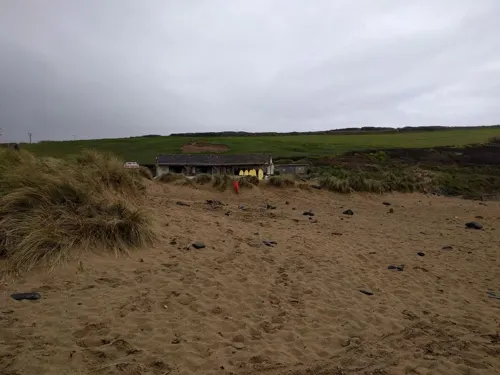

Loe Bar Wreck
Monument and historic site · 3.3 mi
Shipwreck in Cornwall, England, UK
WW2 Anti-aircraft Gun Battery for RAF Predannack (site of)
Monument and historic site · 0.9 mi
Parks, trails and playgrounds7



Restaurants and cafes7



Where to stay7


History
There is evidence for Bronze Age burial mounds, Celtic crosses and ancient chapel sites in the parish, and in more recent times evidence of copper and china clay mining. Several barrows at Angrowse yielded prehistoric remains when excavated. There is a Cornish cross near the hamlet of Predannack. It has a broad Latin cross on the front and an incised Latin cross on the back.
The existence of a Celtic church here is indicated by the place-names Tremenehee (meaning "sanctuary town") and Lanfrowder (cognate with Lafrowda, the Cornish name of St Just in Penwith) nearby. In Norman times the church of St Melanus lay in the fief of Rosewick; John de Rivers gave it to Mottesfont Priory in 1291 but in 1309 the priory conveyed it to the Dean and Chapter of Exeter. The vicarage was established in 1310 and the chancel of the church was rebuilt before 1331 by the executors of Bishop Bytton of Exeter. Of this chancel part remains but most of the church was built in the 15th century. Robert Luddra (vicar 1512–47) was also provost of Glasney College; he increased the endowment of the vicarage, and contributed funds for the roofs and tower. Features of interest include the fine series of bench ends and other old woodwork.
Read more of the history
In the six years up to 1873 there were nine wrecks along a mile-and-a-half stretch of coastline under Mullion cliffs with the loss of sixty-nine lives. The Royal National Lifeboat Institution stationed a lifeboat at Mullion Cove in 1867 but was withdrawn in 1908. The boat house has since been demolished but its barometer is on display in the village.
Like many other Cornish coastal villages there was a pilchard fishery, controlled by seining companies which started in the 18th century out of Mullion Cove. Caught by a seine net, the pilchards were cured at Newlyn and exported to Mediterranean countries. The companies posted a huer (a lookout) on Mullion Island to watch for the dark patch of a nearby shoal of pilchards. There are still a few boats operating a small shellfish industry.
There were a few short-lived copper mines in Mullion parish; first mentioned in a deed of 1741 and the mine(s) had a number of names; Ghost Croft, Goosecroft, Predannack Wartha, South Wheal Unity, Trenance and Wheal Providence. Wheal Unity (or Goosecroft), to the south of Churchtown, opened in 1847, and to the south-east of Pollurian Cove was a mid-19th-century copper mine called Wheal Fenwick. A native copper sheet, found in 1847, and with the dimensions of 9 metres (29'6") x 1.4 metres (4'8") x 15 cm (6") and weighing over 700 kg (14 cwt), from Wheal Unity was exhibited at the 1851 Great Exhibition in London. Compared with the rest of Cornwall, copper mining in Mullion was insignificant and ceased by the end of the 19th century. The mine buildings have disappeared but an adit can still be seen in Mullion Cove.
Talc was quarried in Soapy Cove in the south of the parish during the 18th century. The talc occurs locally as veins in the serpentinite, often known just as 'serpentine' (serpentinite is rich in serpentine minerals). The old quarries form an irregular scar heading from the shore inland. It was used for early porcelain production by Benjamin Lund in Bristol and taken over by the Worcester Porcelain Manufacturers in 1752.
Poldhu is the site of one of the main technological advances of the early twentieth century when in 1901, a Wireless signal was sent to St John's, Newfoundland, by Marconi. The technology was a precursor to radio, television, satellites and the internet, with Goonhilly Satellite Earth Station a nearby example.
Predannack Airfield was established by the RAF during World War II, and since 1958 has been used by the Royal Navy.
From the History section of Mullion, Cornwall on Wikipedia, under CC BY-SA 4.0.
More about Mullion
Geography
The parish comprises 5,007 acres (20 km2) of land, 8 acres (3.2 ha) of water and 55 acres (22 ha) of foreshore. It is on the Lizard Peninsula, which lies within the Cornwall National Landscape area. Mullion contains three designated Sites of Special Scientific Interest (SSSIs) – West Lizard SSSI, Baulk Head to Mullion SSSI and Mullion Cliff to Predannack Cliff SSSI, which includes Mullion Island. Mullion Cliff to Predannack Cliff SSSI is noted for its geological and biological interest and contains ten Red Data Book of rare and endangered plant species. Much of the Lizard National Nature Reserve (NNR) is within the parish boundary. The South West Coast Path, which follows the coast of south-west England from Somerset to Dorset passes by on the cliffs along the western edge of the parish.
From the Wikipedia article Mullion, Cornwall, under CC BY-SA 4.0.
Notable people from Mullion
 Andrew GeorgeBritish politician (born 1958)Photo: ©House of Commons / photography by..., CC BY 3.0
- Martin RobertsWelsh cricketer (born 1966)
- Ernest Herbert Pitcherrecipient of the Victoria Cross
Born in Mullion, according to Wikidata (CC0). Each name links to its Wikipedia article.
Churches and places of worship6
Shopping4
Schools, colleges and libraries3
Healthcare1
Map of Mullion
43 places. The map loads OpenStreetMap tiles when you open it.
Getting there and nearby towns
Land's End Airport (LEQ) is the nearest airport with scheduled flights listed in OpenStreetMap, 20 miles away.
- Helston 5 mi north, about 9 min by car
- Falmouth 12 mi northeast, about 19 min by car
- Four Lanes 12 mi north, about 19 min by car
- Marazion 12 mi northwest, about 20 min by car
- Camborne 13 mi north, about 21 min by car
- Mylor Bridge 13 mi northeast, about 21 min by car
- Redruth 14 mi north, about 23 min by car
- Uny Lelant 14 mi northwest, about 22 min by car
- Penzance 15 mi northwest, about 23 min by car
- Truro 18 mi northeast, about 30 min by car
Drive times are estimates from straight-line distance, not routes.
Towns near Mullion


Keep exploring
Local news
Headlines from INDB.
Reviews, tips and questions
Loading what members have shared...
Sources and licences
- GeoNames (CC BY 4.0): population, coordinates, regions and time zone
- Mapillary (see each image): photos
- OpenStreetMap contributors (ODbL 1.0): places, airports, map data
- Wikidata (CC0 1.0): elevation, founding date, time zone, website, landmarks and historic places
- Wikimedia Commons (see each image): photos
- Wikipedia (CC BY-SA 4.0): overview and history text
Photo credits
- St Mellanus Church Mullion, Lizard Fine Art, CC BY-SA 4.0
- 2024 St Winwaloe's Church, Gunwalloe (09), Chris06, CC BY-SA 4.0
- 2024 St Corentine's Church (Cury) (01), Chris06, CC BY-SA 4.0
- Marconi moument at Poldhu, Nilfanion, CC BY-SA 3.0
- The Marconi Company second antenna system at Poldhu, Cornwall, Unknown author Unknown author, Public domain
- Church of St Mellanus, Jowaninpensans, CC BY-SA 4.0
- Church of St Mellanus 04, Jowaninpensans, CC BY-SA 4.0
- Church of St Mellanus 01, Jowaninpensans, CC BY-SA 4.0
- Church of St Mellanus 09, Jowaninpensans, CC BY-SA 4.0
- Church of St Mellanus 03, Jowaninpensans, CC BY-SA 4.0
- Church of St Mellanus 06, Jowaninpensans, CC BY-SA 4.0
- Church of St Mellanus 12, Jowaninpensans, CC BY-SA 4.0
- Church of St Mellanus 10, Jowaninpensans, CC BY-SA 4.0
- Church of St Mellanus 07, Jowaninpensans, CC BY-SA 4.0
- Church of St Mellanus 08, Jowaninpensans, CC BY-SA 4.0
- Church of St Mellanus 11, Jowaninpensans, CC BY-SA 4.0
- Poldhu Cove - beach - panoramio, KalivonGall, CC BY-SA 3.0
- Street-level photo, adam2, CC BY-SA 4.0
- Street-level photo, WaggyDog, CC BY-SA 4.0
- Street-level photo, adam2, CC BY-SA 4.0
- Street-level photo, adam2, CC BY-SA 4.0
- Street-level photo, adam2, CC BY-SA 4.0
- Street-level photo, adam2, CC BY-SA 4.0
- Street-level photo, adam2, CC BY-SA 4.0
- Street-level photo, adam2, CC BY-SA 4.0
- Street-level photo, adam2, CC BY-SA 4.0
- Street-level photo, adam2, CC BY-SA 4.0
- Street-level photo, adam2, CC BY-SA 4.0
- Street-level photo, adam2, CC BY-SA 4.0


Page built November 10, 2026. Spotted a mistake? Tell us or suggest a place.