

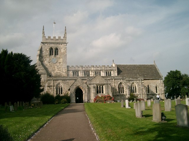
South Milford, United Kingdom
South Milford is a town of 1,995 people in England, United Kingdom.
Why visit South Milford
Townapedia lists 4 museums and landmarks, 4 parks and trails, 21 places to eat, 1 place to stay and 1 attraction in and around town.
Highlights include Battle of Sherburn in Elmet, Site of King Athelstan's Palace and South Milford Park.
Weather in South Milford
Forecast from MET Norway (CC BY 4.0). Full forecast
About South Milford
South Milford is a village and civil parish in the county of North Yorkshire, England. The civil parish includes the hamlet of Lumby, located south-west of the main village.
From the Wikipedia article South Milford (this version), under CC BY-SA 4.0.
Things to do1

Museums and landmarks4

Battle of Sherburn in Elmet
Monument and historic site · 1.4 mi
Part of the English Civil War; victory for the Parliamentarians uner Sydnam Poyntz
Parks, trails and playgrounds4


Restaurants and cafes21

MALT Bar & Deli
Cafe · 1.4 mi
8 Low Street, Leeds
Mo, Tu 08:00-17:00; We, Su 08:00-22:00; Th, Fr 08:00-23:00



9 more on the map.
History
Milford is first recorded in 963 as on niy senford, which means Mylenforda, or mill on the ford. The name derives from Anglo-Saxon, and though it predates the Domesday Book, it is not explicitly mentioned, though North Milford near Kirkby Wharfe is.
The mill was located in the north of the parish on Mill Dike, the body of water which separates South Milford from Sherburn. The watercourse runs from Micklefield to Sherburn and eventually falls into the Ouse at Cawood.
South Milford is served by South Milford railway station, part of the Leeds and Selby Railway - a line that runs west/east across the north of the village. It has been in operation since 1834 and provides a service between Leeds, Selby and Hull. South Milford lies at the convergence of several lines, and was an important staging post in coal traffic between the pits and the power stations in the Aire Valley. Another station, Milford Junction, was located on lines running north/south, but this closed in 1904, being replaced by Monk Fryston, which closed in 1959.
Read more of the history
Steeton Hall Gateway is a listed ancient monument and is protected by English Heritage. It is situated about 1.5 miles (2.4 km) west of South Milford. The gateway originally served a large hall, which was demolished and replaced by a house, which has since been converted into several dwellings. The gateway dates from the 15th century, and is one of four such structures which marked the corners of the estate. It has two arched passages, the large one in the centre to allow horsemen and carriages through and the smaller one to the left for footmen.
There are a spiral staircase which leads into a large room above the arch and a number of shields and coats of arms surrounding the structure.
Steeton Hall Gateway has been described as a "fair and stately structure in the brave days of old".
From the History section of South Milford on Wikipedia, under CC BY-SA 4.0.
Where to stay1
Churches and places of worship11
Shopping4
Gas and EV charging1
Schools, colleges and libraries5
Healthcare3
Map of South Milford
55 places. The map loads OpenStreetMap tiles when you open it.
Getting there and nearby towns
Leeds Bradford Airport (LBA) is the nearest airport with scheduled flights listed in OpenStreetMap, 18 miles away.
- Monk Fryston 1 mi south, about 2 min by car
- Church Fenton 4 mi north, about 6 min by car
- Byram 4 mi south, about 6 min by car
- Knottingley 5 mi south, about 8 min by car
- Kippax 5 mi west, about 8 min by car
- Ferrybridge 5 mi south, about 8 min by car
- Aberford 5 mi northwest, about 8 min by car
- Castleford 6 mi southwest, about 10 min by car
- Garforth 6 mi west, about 9 min by car
- Pontefract 7 mi southwest, about 10 min by car
Drive times are estimates from straight-line distance, not routes.
Towns near South Milford


Keep exploring
Local news
Headlines from INDB.
Reviews, tips and questions
Loading what members have shared...
Sources and licences
- GeoNames (CC BY 4.0): population, coordinates, regions and time zone
- OpenStreetMap contributors (ODbL 1.0): places, airports, map data
- Wikidata (CC0 1.0): elevation, founding date, time zone, website, landmarks and historic places
- Wikimedia Commons (see each image): photos
- Wikipedia (CC BY-SA 4.0): overview and history text
Photo credits
- Methodist Chapel, Monk Fryston (former) (8048130815), Tim Green from Bradford, CC BY 2.0
- All Saints Church, Sherburn in Elmet, John Davidson, CC BY-SA 2.0
Page built November 10, 2026. Spotted a mistake? Tell us or suggest a place.