




Why visit Wouldham
Townapedia lists 9 museums and landmarks, 14 parks and trails, 23 places to eat and 2 attractions in and around town.
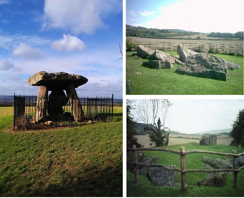
Highlights include Medway Viaducts, Coffin Stone, Medway megaliths and Burham Down.
Weather in Wouldham
Forecast from MET Norway (CC BY 4.0). Full forecast
About Wouldham
Wouldham is a village on the bank of the River Medway in Kent, England. In 2011 its population was approximately 1500, which has increased since 2017, with substantial housing development to the south of the village. It has an 11th-century church, two schools – a primary school and one for those with special educational needs, and two public houses, The Medway Inn and The Waterman's Arms.
From the Wikipedia article Wouldham (this version), under CC BY-SA 4.0.
Things to do2


Museums and landmarks9

Coffin Stone
Monument and historic site · 2.7 mi
Archaeological artifact in Kent, England

Medway megaliths
Museum · 2.9 mi
Group of long barrows in Kent, England

Restoration House
Museum · 3.2 mi
Historic house and museum in Rochester, Kent, England, United Kingdom

Smythe's Megalith
Monument and historic site · 3.4 mi
Neolithic monument in Kent, England

Temple Manor
Museum · 3.0 mi
Grade I listed historic house museum in Medway, United Kingdom

White Horse Stone
Monument and historic site · 3.4 mi
Two megaliths near Aylesford, Kent, England

Eccles Roman Villa
Monument and historic site · 2.3 mi
Roman villa in the UK
Parks, trails and playgrounds14






St Andrews Lakes Watersports
Sports field and stadium · 1.1 mi
We,Sa-Su 08:00-19:00; Mo-Tu,Th-Fr 10:00-19:00

2 more on the map.
Restaurants and cafes23
Costa
Cafe · Coffee Shop · 0.8 mi
Holborough Road, Snodland
Mo-Fr 07:00-19:00; Sa 07:00-19:00; Su 08:00-17:00

Moot Brew Co Brewery and Taproom
Bar and pub · 1.4 mi
Pilgrims Road, Upper Halling
Th-Fr 12:00-21:00; Sa 10:00-21:00; Su 10:00-18:00

11 more on the map.
History
The tusk and teeth of a mammoth were excavated in Peters Pit and displayed in Rochester Guildhall Museum. In 1982, the skull of an 18-year-old teenager was excavated, dated as 1500 BC. Oral history suggests that the village was occupied when the Romans arrived, and that they constructed a ford across the Medway. The site of a temple dedicated to Mithras has been excavated and occurs on old maps.
On the Wouldham Marshes is Starkey House built in 1483: a now restored Grade I listed medieval manor house called Starkey Castle.
In the churchyard, is the grave of Walter Burke, who was present on board HMS Victory at the battle of Trafalgar and the man who held Nelson in his arms as he died.
Wouldham primary school celebrates this connection in several ways, with its four sports teams being named after ships at the Battle of Trafalgar (Victory, Ajax, Sovereign, Britannia), students being assigned into a house named after one of four famous figures at Trafalgar, and by holding an annual event at the nearby church to commemorate Walter Burke.
A narwhal was discovered in the 1940s washed up on the bank of the river, and is documented in the Natural History Museum, London.
Until 1963 there was a ferry crossing over the Medway to Halling on the opposite bank.
From the History section of Wouldham on Wikipedia, under CC BY-SA 4.0.
Notable people from Wouldham
 Henry Tracey CoxwellBritish balloonist (1819-1900)Photo: Rijksmuseum, CC0
- Robert BarkerEnglish footballer (1847-1915)
- Jimmy FletcherEnglish footballer (born 1931)
Born in Wouldham, according to Wikidata (CC0). Each name links to its Wikipedia article.
Churches and places of worship13
Shopping3
Gas and EV charging2
Schools, colleges and libraries4
Wouldham All Saints Church of England Voluntary Controlled Primary School
School · Anglican · 0.4 mi
1 Worrall Drive, Rochester
Map of Wouldham
70 places. The map loads OpenStreetMap tiles when you open it.
Getting there and nearby towns
Rochester Airport (RCS) is the nearest airport with scheduled flights listed in OpenStreetMap, 2 miles away.
- Snodland 2 mi southwest, about 2 min by car
- Rochester 3 mi northeast, about 5 min by car
- Chatham 4 mi northeast, about 6 min by car
- Gillingham 5 mi northeast, about 8 min by car
- Maidstone 6 mi southeast, about 10 min by car
- Gravesend 7 mi northwest, about 12 min by car
- Hartley 7 mi west, about 11 min by car
- Longfield 7 mi northwest, about 12 min by car
- Tilbury 9 mi northwest, about 14 min by car
- Swanscombe 9 mi northwest, about 15 min by car
Drive times are estimates from straight-line distance, not routes.
Towns near Wouldham


Keep exploring
Local news
Headlines from INDB.
Reviews, tips and questions
Loading what members have shared...
Sources and licences
- GeoNames (CC BY 4.0): population, coordinates, regions and time zone
- Mapillary (see each image): photos
- OpenStreetMap contributors (ODbL 1.0): places, airports, map data
- Wikidata (CC0 1.0): elevation, founding date, time zone, website, landmarks and historic places
- Wikimedia Commons (see each image): photos
- Wikipedia (CC BY-SA 4.0): overview and history text
Photo credits
- MedwayM2Bridge5567, Clem Rutter, Rochester Kent, CC BY-SA 3.0
- Coffin Stone, Blue Bell Hill, Kent 01, Simon Burchell, CC BY-SA 4.0
- Three Medway Megaliths, Midnightblueowl at English Wikipedia, CC BY-SA 3.0
- Restoration House, Rochester, SilkTork, CC BY-SA 3.0
- Smythe's Megalith field, Ethan Doyle White, CC BY-SA 3.0
- Strood TempleManor Left, Clem Rutter, Rochester, Kent., CC BY 2.5
- Upper White Horse Stone, Roger Smith, CC BY-SA 2.0
- Burham Down 3, Dudley Miles, CC BY-SA 4.0
- Burham Marsh 4, Dudley Miles, CC BY-SA 4.0
- Nashenden Down 3, Dudley Miles, CC BY-SA 4.0
- Rede Common Local Nature Reserve 4842, ClemRutter, CC BY-SA 4.0
- Southern End of the Church of St Nicholas, Rochester (01), Ethan Doyle White, CC BY-SA 4.0
- Church of All Saints, Snodland, Tonbridge & Malling, Kent, Christopher Nicol, CC BY-SA 3.0
- Wouldham5526, Clem Rutter, Rochester Kent, CC BY-SA 3.0
- Street-level photo, paulbiv, CC BY-SA 4.0
- Street-level photo, paulbiv, CC BY-SA 4.0
- Street-level photo, paulbiv, CC BY-SA 4.0
- Street-level photo, paulbiv, CC BY-SA 4.0
- Street-level photo, paulbiv, CC BY-SA 4.0
- Street-level photo, paulbiv, CC BY-SA 4.0
- Street-level photo, paulbiv, CC BY-SA 4.0
- Street-level photo, paulbiv, CC BY-SA 4.0
- Street-level photo, paulbiv, CC BY-SA 4.0
- Street-level photo, paulbiv, CC BY-SA 4.0
- Street-level photo, paulbiv, CC BY-SA 4.0
- Street-level photo, paulbiv, CC BY-SA 4.0
- Street-level photo, paulbiv, CC BY-SA 4.0
- Street-level photo, paulbiv, CC BY-SA 4.0
- Street-level photo, paulbiv, CC BY-SA 4.0
- Street-level photo, paulbiv, CC BY-SA 4.0
- Street-level photo, paulbiv, CC BY-SA 4.0
- Street-level photo, paulbiv, CC BY-SA 4.0
- Street-level photo, paulbiv, CC BY-SA 4.0
- Street-level photo, paulbiv, CC BY-SA 4.0
- Street-level photo, paulbiv, CC BY-SA 4.0
- Street-level photo, paulbiv, CC BY-SA 4.0
- Street-level photo, paulbiv, CC BY-SA 4.0
- Street-level photo, paulbiv, CC BY-SA 4.0
- Street-level photo, paulbiv, CC BY-SA 4.0


Page built November 10, 2026. Spotted a mistake? Tell us or suggest a place.