


Thamesmead, United Kingdom
Thamesmead is a town of 31,824 people in England, United Kingdom.
Why visit Thamesmead
Townapedia lists 21 museums and landmarks, 44 parks and trails, 31 places to eat, 1 place to stay and 5 attractions in and around town.
Highlights include The Broadway, Erith Playhouse, Crossness Pumping Station and Danson House.
Weather in Thamesmead
Forecast from MET Norway (CC BY 4.0). Full forecast
About Thamesmead
Thamesmead () is an area of south-east London, England, straddling the border between the Royal Borough of Greenwich and the London Borough of Bexley. It is located 11 miles (18 km) east of Charing Cross, north-east of Woolwich and west of Belvedere. It mainly consists of social housing built from the mid-1960s onwards on former marshland on the south bank of the River Thames.
From the Wikipedia article Thamesmead (this version), under CC BY-SA 4.0.
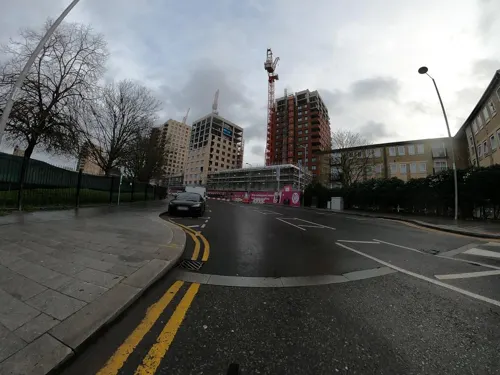
Photos of Thamesmead


Things to do5

The Broadway
Cinema and theater · 2.8 mi
Theatre in Barking, London, England, part of Barking Town Hall

Erith Playhouse
Cinema and theater · 2.8 mi
Theatre in Erith, Bexley, London, England, formerly a cinema

Thames Gateway Bridge
Bridge · 1.5 mi
Proposed new crossing of the River Thames, in east London, England

Museums and landmarks21


Danson House
Museum · 3.3 mi
Grade I listed historic house museum in London Borough of Bexley, United Kingdom
East End Women's Museum
Museum · 2.8 mi
Women's Museum in London Barking, United Kingdom

Eastbury Manor House
Museum · 2.3 mi
Grade I listed historic house museum in London Borough of Barking and Dagenham, United Kingdom

Greenwich Heritage Centre
Museum · 2.3 mi
Former museum in local history resource centre in Woolwich, London, UK

North Woolwich Old Station Museum
Museum · 2.5 mi
Former railway museum in North Woolwich, London, opened 1984, closed 2008

Rainham Hall
Museum · 3.2 mi
Historic house museum in Rainham, London Borough of Havering, UK

Rainham War Memorial
Monument and historic site · 3.2 mi
War memorial in London

Red House
Museum · 3.4 mi
Grade I listed historic house museum, former home of William Morris


Royal Artillery Museum
Museum · 2.2 mi
Closed military museum in London, United Kingdom

South African War Memorial
Monument and historic site · 2.8 mi
War memorial in Woolwich, London
9 more on the map.
Parks, trails and playgrounds44


Dagenham Village Churchyard
Park · 3.0 mi
Church in London Borough of Barking and Dagenham, UK

Danson Park
Park · 3.3 mi
Park in the London Borough of Bexley, England, UK


Lesnes Abbey Woods
Park · 1.1 mi
Area of ancient woodland in southeast London, England



32 more on the map.
Restaurants and cafes31


The Abbey Arms
Bar and pub · 0.9 mi
31 Wilton Road, London
Mo,Tu 15:00-23:00; We-Sa 12:00-23:00; Su 12:00-22:00
The Exchange
Bar and pub · 1.0 mi
Project Road, Barking
Fr 17:00-21:00; Sa 14:00-22:00; Su 14:00-19:00

19 more on the map.
History
There is some evidence of prehistoric human occupation of the area: flints, animal bones and charcoal were found in bore holes around Western and Central Way in 1997 by the Museum of London Archaeological Service (MOLAS). In Roman times, the river level was significantly lower, and work by MOLAS in 1997 around Summerton Way revealed evidence of field ditches and pottery and quernstones from Germany dating from around the 3rd or 4th century. After the Roman era, river levels rose again and the area reverted to marshland. According to Hasted, some areas of this marshland were drained in 1279 by the monks of Lesnes Abbey.
Between 1812 and 1816, a canal was built by convicts to take materials such as timber from the River Thames to Woolwich Royal Arsenal. Much of this canal has been filled in, but part remains in Thamesmead West and is now called the Broadwater. A disused lock gate and swing bridge over the canal still exist beside the River Thames.
Most of the land area of Thamesmead previously formed about 1,000 acres (4.0 km2) of the old Royal Arsenal site that extended over Plumstead Marshes and Erith Marshes.
Read more of the history
Thamesmead as it is now was built at the end of the 1960s. Efforts were made to solve the social problems that had already started to affect earlier estates. These were believed to be the result of people being uprooted from close-knit working-class communities and sent to estates many miles away, where they did not know anybody. The design of the new estates meant that people would feel more isolated than they would have done in the terraced housing that had been typical in working-class areas. The solution proposed was that once the initial residents had moved in, their families would be given priority for new housing when it became available.
Another radical idea of the GLC division architect Robert Rigg was taken from housing complexes in Sweden, where it was believed that lakes and canals reduced vandalism and other crime, mainly among the young. He used water as a calming influence on the residents.
Much of Thamesmead was initially built by the Greater London Council (GLC) for rent to families moving from overcrowded back-to-back Victorian housing (also referred to as slums) in south eastern parts of Inner London. The area had been inundated in the Flood of 1953, so the original design placed living accommodation at first floor level or above, used overhead walkways and left the ground level of buildings as garage space. There is also an elevated 'escape route' from the estate to be used in the event of flooding, which runs along the top of a grassed mound to the north of Lesnes neighbourhood.
The first residence was occupied in 1968, but already there were rain penetration problems. The pre-1974 parts of Thamesmead are a mix of modernist town houses, medium-rise and 12-storey blocks system built in concrete, which have featured in various films due to their 'rough urban look'; the design of the newer buildings is more traditional and in brick.
In 1985, the government abolished the GLC. They transferred ownership of Thamesmead to Thamesmead Town Limited (TTL) which was formally established in 1986, following a public vote. Its nine executive directors were local residents; they periodically submitted themselves to re-election. Subsequently six additional paid directors who did not live in the area were appointed.
The design did not accurately predict the lived experience of residents, and many people avoided the elevated pathways linking the houses, choosing instead to walk across open patches of grass included in the landscaping.
In 2000, TTL was wound down and two new organisations were formed. In broad terms, Gallions Housing Association took over the ownership and management of the housing assets whilst Tilfen, later Tilfen Land, took over the remaining undeveloped land. Tilfen is jointly owned by Gallions and Trust Thamesmead. District heating and cable radio broadcasting were pioneered in Thamesmead. The District heating system was decommissioned around 2000; properties connected to it had wet radiator systems installed by the landlord.
The Tavy Bridge area was redeveloped by Gallions in partnership with Wates Group; the plans included homes with dwelling space at ground-floor level, making them susceptible to any future flooding. The Lesnes estate is also planned to be demolished and redeveloped by Bexley Council and the Peabody Trust.
Thamesmead now features a retail park finished in brick anchored around a Morrisons Supermarket; there is also a shopping parade which has mainly service-based outlets such as hairdressers and estate agents. It features a clock tower and a lake. Some of the original overhead pedestrian walkways have been demolished for reasons of public safety and some ground-floor garages have been unfilled, as incidents of crime deterred their use as parking space.
Trust Thamesmead is a registered charity set up to provide community services across Thamesmead. It runs six community centres and a variety of projects promoting social development and work and training projects.
Thamesmead West contains Gallions Ecopark, a pioneering small social/affordable housing development with homes built to high energy efficiency and environmental standards. The estate also includes a small lake and a number of man-made landmarks created from recycled excavated materials that serve as viewing platforms. The biggest of these is the 20 m (66 ft) high Gallions Hill, with a spiral path leading to the summit.
Part of Thamesmead West is also sometimes referred to as Gallions Reach Urban Village. This can lead to confusion, as it is on the opposite bank of the River Thames from Gallions Reach DLR station and Gallions Reach shopping park. There is no Docklands Light Railway, London Underground or rail station in Thamesmead West. Many new build properties in Thamesmead West in the early 21st century have been blighted by social problems and mass repossessions.
From the History section of Thamesmead on Wikipedia, under CC BY-SA 4.0.
More about Thamesmead
Geography
Thamesmead is located 11 miles (18 km) east of central London, being on the same latitude as Westminster. In Thamesmead East, the River Thames makes its most northerly incursion within Greater London near the Crossness Sewage Treatment Works.
Thamesmead South and Thamesmead East is in Bexley and is the location of the original development built in the late 1960s to early 1970s. The buildings are almost entirely of concrete, in a Cubist/Brutalist/Modernist style, and include a number of high-rise blocks. It is east of Harrow Manorway (A2041) and south of the A2016. Postcode(s): SE2, DA18
Thamesmead North is in Greenwich and Bexley and is north of the A2016 and east of the A2041. Built from the 1970s onwards, it was initially made up of town houses in grey brick; more recent builds are in red & yellow brick. Postcode(s): SE2, SE28
Thamesmead Central is in Greenwich and was first developed in the early 1980s in the ring between the A2016 and A2041. It originally consisted of large, sprawling, concrete and red brick, eight- and nine-storey estates overlooking the A2041, and three-storey red-brick town houses. It has spread west of the A2041 and now also includes a number of red and yellow brick homes built from the 1990s onwards. Postcode(s): SE28
Arts and culture
Places of worship in the area include the Thamesmead Ecumenical Parish, with shared buildings and co-operation by the Methodist Church, Church of England, United Reformed Church and Roman Catholic Church, and the Redeemed Christian Church of God, Goodnews Haven on Nathan Way.
The local football team was formerly Thamesmead Town, founded in 1969, who played at Bayliss Avenue until folding in October 2018 due to budgetary issues. Sporting Club Thamesmead, who had a groundshare deal with Thamesmead Town, continue to play at Bayliss Avenue. As of 2026, they compete in the Southern Counties East League First Division.
The Thamesmead Riverside Walk runs alongside the Thames through Thamesmead West, Thamesmead Central and Thamesmead North and is part of both the Thames Path Southeast Extension and National Cycle Route 1. Thamesmead is also one of the starting points of the Green Chain Walk, which links to places such as Chislehurst and Crystal Palace.
There is a combined swimming pool, fitness centre and library run by Greenwich Council and Greenwich Leisure Limited in Thamesmead Central (The Thamesmere Centre).
In 2026, a newly constructed library called The Nest was chosen by Poet Laureate Simon Armitage as one of the venues for his annual library tour which in that year visited libraries in places with initials N-P.
Education
The Bishop John Robinson CofE School is a voluntary-aided primary school with a nursery in Hoveton Road, Thamesmead, named after John Robinson, Bishop of Woolwich. Harris Garrard Academy (formerly Bexley Business Academy) is a secondary school located in Thamesmead. Woolwich Polytechnic School for Boys, as well as Woolwich Polytechnic School for Girls is also located in Thamesmead.
From the Wikipedia article Thamesmead, under CC BY-SA 4.0.
Notable people from Thamesmead
- EnnyEnglish rapper, singer and songwriter
- Ryan BarrettBritish boxer
- Tobi Sho-Silvaassociation football player (born 1995)
Born in Thamesmead, according to Wikidata (CC0). Each name links to its Wikipedia article.
Where to stay1
Churches and places of worship32
Shopping8
Gas and EV charging1
Schools, colleges and libraries32
St Augustine of Canterbury CofE Primary School
School · Anglican · 1.4 mi
St Augustines Road, Belvedere
Healthcare6
Map of Thamesmead
181 places. The map loads OpenStreetMap tiles when you open it.
Getting there and nearby towns
London City Airport (LCY) is the nearest airport with scheduled flights listed in OpenStreetMap, 3 miles away.
- Abbey Wood 1 mi southwest, about 2 min by car
- Plumstead 2 mi southwest, about 3 min by car
- Barking 3 mi northwest, about 4 min by car
- Rainham 3 mi east, about 5 min by car
- Dagenham 4 mi northeast, about 6 min by car
- Charlton 4 mi west, about 6 min by car
- Ilford 4 mi northwest, about 7 min by car
- Bexley 4 mi south, about 7 min by car
- Goodmayes 4 mi north, about 7 min by car
- Manor Park 4 mi northwest, about 7 min by car
Drive times are estimates from straight-line distance, not routes.
Towns near Thamesmead


Keep exploring
Local news
Headlines from INDB.
Reviews, tips and questions
Loading what members have shared...
Sources and licences
- GeoNames (CC BY 4.0): population, coordinates, regions and time zone
- Mapillary (see each image): photos
- OpenStreetMap contributors (ODbL 1.0): places, airports, map data
- Wikidata (CC0 1.0): elevation, founding date, time zone, website, landmarks and historic places
- Wikimedia Commons (see each image): photos
- Wikipedia (CC BY-SA 4.0): overview and history text
Photo credits
- 2015 London-Abbey Wood, Thamesmead South 02, Kleon3, CC BY-SA 4.0
- 2015 London-Abbey Wood, Thamesmead South 01, Kleon3, CC BY-SA 4.0
- Footbridge across Eastern Way, Thamesmead, Ewan-M, CC BY-SA 2.0
- Eastern Way, Thamesmead, Ewan-M, CC BY-SA 2.0
- Danson Mansion, Stacey Harris, CC BY-SA 2.0
- Eastbury Manor House, Gordon Joly, CC BY 2.5
- Flickr - davehighbury - Royal Arsenal Woolwich London 039 (cropped), DAVID HOLT from London, England, CC BY-SA 2.0
- London Borough of Havering - Rainham Hall - 20180928114458, JRennocks, CC BY-SA 4.0
- Rainham War Memorial, Fay1982, CC BY-SA 3.0
- The Red House, Bexleyheath, Velela, Public domain
- London-Woolwich, Second Boer War Memorial 03, Kleon3, CC BY-SA 4.0
- Crossness Nature Reserve 1, Dudley Miles, CC BY-SA 3.0
- Beckton District Park South, Dudley Miles, CC0
- Dagenham Village Churchyard 6, Dudley Miles, CC BY-SA 3.0
- Danson Park, Stacey Harris, CC BY-SA 2.0
- Greatfields Park (18843012584), Matt Brown from London, England, CC BY 2.0
- Nave of Lesnes Abbey, Ethan Doyle White, CC BY-SA 4.0
- Mayesbrook Park 2, Dudley Miles, CC BY-SA 3.0
- Parsloes Park, London Borough of Barking & Dagenham, RM9 (400631455), Ewan Munro from London, UK, CC BY-SA 2.0
- London, Plumstead Common 04, Kleon3, CC BY-SA 4.0
- Rainham Church 2007, Max Naylor, Public domain
- Woolwich Granada Cinema, Simon Armstrong, CC BY-SA 3.0
- Woolwich, Beresford Square, c 1835, Unknown author, Public domain
- New Wine Church building, Danny Robinson, CC BY-SA 2.0
- Church of St Nicholas plumstead, Simon Armstrong, CC BY-SA 3.0
- Exterior of Crossness Pumping Station, Ethan Doyle White, CC BY-SA 3.0
- Babe grafitti, James Nash (aka Cirrus), CC BY-SA 2.0
- Old couch, James Nash (aka Cirrus), CC BY-SA 2.0
- Big, pink tag, James Nash (aka Cirrus), CC BY-SA 2.0
- Broadway, Barking, IG11 (4497643932), Ewan Munro from London, UK, CC BY-SA 2.0
- London, North Woolwich Old Station Museum 01, Kleon3, CC BY-SA 4.0
- London-Woolwich, Rotunda 06, Kleon3, CC BY-SA 4.0
- Flickr - davehighbury - Royal Artillery Museum Woolwich London 158, DAVID HOLT from London, England, CC BY-SA 2.0
- Ripple Nature Reserve 5, Dudley Miles, CC BY-SA 3.0
- Barking Park, Simon from London, United Kingdom, CC BY 2.0
- Street-level photo, dankarran, CC BY-SA 4.0
- Street-level photo, dankarran, CC BY-SA 4.0
- Street-level photo, wasd42, CC BY-SA 4.0
- Street-level photo, dankarran, CC BY-SA 4.0
- Street-level photo, dankarran, CC BY-SA 4.0
- Street-level photo, dankarran, CC BY-SA 4.0
- Street-level photo, wasd42, CC BY-SA 4.0
- Street-level photo, dankarran, CC BY-SA 4.0
- Street-level photo, IpswichEdits, CC BY-SA 4.0
- Street-level photo, dankarran, CC BY-SA 4.0
- Street-level photo, wasd42, CC BY-SA 4.0
- Street-level photo, dankarran, CC BY-SA 4.0
- Street-level photo, dankarran, CC BY-SA 4.0
- Street-level photo, jjhaslanded, CC BY-SA 4.0
- Street-level photo, dankarran, CC BY-SA 4.0
- Street-level photo, dankarran, CC BY-SA 4.0
- Street-level photo, wasd42, CC BY-SA 4.0


Page built November 10, 2026. Spotted a mistake? Tell us or suggest a place.